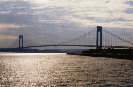
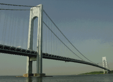
This 1998 photo shows the Verrazano-Narrows Bridge from Dyker Beach Park in Brooklyn at sunset. (Photo by Steve Anderson.)
THE NEED FOR A NARROWS CROSSING: From The Great Bridge by Edward M. Young and Lili Rethi:
Until the building of the Narrows Bridge, the island's only connections with New York were ferries that crossed the harbor between the island, Manhattan and Brooklyn. Under normal conditions, the five miles crossing to Manhattan could be made in half an hour, the mile crossing to Brooklyn in about ten minutes. But if the bay was heavy with ice, or if a fog suddenly closed in, either trip could take much longer. And on clear days, when the ferries had no trouble in making their crossings on schedule, they were often so crowded, particularly on summer weekends, that drivers had to wait for hours to get to one. On the bridge, the crossing to Brooklyn can be made in three or four minutes.
EARLY PLANS: Talk of a Narrows Crossing between Brooklyn and Staten Island, where Upper New York Harbor joins Lower New York Harbor, surfaced as early as 1888. That year, the Baltimore and Ohio (B&O) Railroad announced plans for a tunnel that was to continue the route of its Staten Island North Shore line. Although the proposed tunnel may have expanded the economic fortunes of the B&O, financial constraints and delays in the approval process prevented the project from moving beyond the drawing board.
The unification of the five boroughs making up Greater New York in 1898 provided a renewed impetus for a fixed Narrows crossing. In 1910, Charles Worthington announced his design for a 2,500-foot-long steel arch span. The proposed bridge was to provide not only a 260-foot-high clearance to allow even the tallest ships to pass, but also a monumental gateway to New York City. However, military officials nixed this proposal on the grounds that destruction of the bridge in wartime would bottle up New York Harbor and the Brooklyn Navy Yard, effectively handicapping fighting potential.
In order to get around this obstacle, Federal agencies revisited the rail tunnel solution. In the early 1920's, thanks to the persistent efforts of Mayor John F. Hylan, the New York State Legislature authorized construction of a twin-tube railway tunnel under the Narrows on a line almost directly beneath the current bridge. Preliminary work began on the Brooklyn-Staten Island tunnel, but because of unexpected costs, the work was stopped. (The abandoned portals were derisively called "Hylan's Holes.")
In 1926, bridge engineer David Steinman proposed a suspension bridge with a 4,620-foot-long main span across the Narrows. The bridge's 800-foot-tall Gothic towers would have housed observation decks, beacon lights and bells. This time, civic leaders joined the military in opposition to the bridge crossing. Fiorello LaGuardia, who served as a U.S. Congressman before he became mayor, opposed the proposed financing through private means.
The New York City Board of Transportation floated two additional Narrows Tunnel proposals in 1929 and 1937. In 1941, the New York City Planning Department proposed a link between Brooklyn and Staten Island in its master plan of express highways as follows:
The eventual linking of Staten Island with Brooklyn by a vehicular crossing is desirable for several reasons. It would provide a Staten Island connection that is not hampered by weather conditions, as is the present ferry system. It would form part of a through express route linking southern New Jersey with New England via New York City. It would be part of a through route for express buses connecting Staten Island with Brooklyn and Manhattan. While no cost estimate for this crossing is available, it would appear from an examination of the costs of similar projects in the New York metropolitan area that a single-tube tunnel could be constructed for about $35,000,000, and a two-tube tunnel for about $60,000,000. A suspension bridge, designed to carry six lanes of traffic and future railroad or rapid transit tracks, is another possible solution.
However, all Narrows Crossing proposals were shelved because of the Depression, and later, because of World War II.
THE TBTA STEPS IN: When the New York City Tunnel Authority was absorbed into the Triborough Bridge and Tunnel Authority (TBTA) in 1946, the Narrows Crossing proposal was reappraised. The new TBTA, which was chaired by Robert Moses, recommended building a Narrows Bridge at that location. Compared to a tunnel, a bridge would cost less and take less time to build, and would have a greater traffic capacity.
The same year, the New York State Legislature authorized construction of the Narrows Bridge between Fort Hamilton in Brooklyn and Fort Wadsworth on Staten Island. Between the two Army forts was the narrowest part of New York Harbor, the location that made the most sense for the proposed bridge. Although the value of Fort Hamilton and Fort Wadsworth as defense installations had long since disappeared, the Army was reluctant to relinquish any part of them without a fight.
Over the next several years, Moses was able to gain concessions from the Army. In 1949, the Army Corps of Engineers granted the first approval when it found that the bridge's 228-foot clearance would pose no obstacles for navigation. At the time of this approval, the cost of the proposed span was estimated at $78 million. Later, after lengthy negotiations, the TBTA paid the Army $26 million for the land and new building construction costs at Fort Hamilton and Fort Wadsworth.
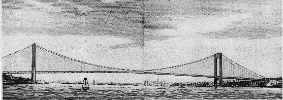
Artist's conception of the Verrazano-Narrows Bridge, as proposed in the 1955 Joint Study of Arterial Facilities. (Photo by Triborough Bridge and Tunnel Authority.)
WHAT THE JOINT STUDY RECOMMENDED: In the mid-1950's, Moses chaired the Joint Study of Arterial Facilities developed by the TBTA and the Port Authority of New York. One of the major proposals of the Joint Study was the Narrows Bridge, which would be tied into Moses' network of expressways and parkways. The new bridge would be a win-win proposal for both agencies: Moses would get the Narrows Crossing that he always wanted to build, while the Port Authority would see increased traffic through Staten Island to the Goethals Bridge and Outerbridge Crossing, both of which had lost money since they opened in 1928.
From the Joint Study:
The Narrows Bridge would connect Fort Wadsworth, Staten Island, and Fort Hamilton, Brooklyn. To cost $220,000,000, the span would comprise two decks, each of which would carry six lanes of traffic.
Including the immediate approaches, the bridge would be 2.7 miles long. From anchorage to anchorage, the structure would extend 7,200 feet with a 4,620-foot center span, the world's longest. This compares with the 4,200-foot center span of the Golden Gate Bridge in San Francisco, and the 3,500-foot center span of the George Washington Bridge. The roadway would be suspended from cables supported by 700-foot towers on the Brooklyn and Staten Island sides.
The lower deck of the bridge would be suspended 237 feet above the Narrows at mid-channel, providing clearance for all commercial and naval shipping.
The entire bridge would be built initially but only the lower six-lane deck would be used at the outset, with three lanes in each direction accommodating all types of vehicles. Completion of ramps and approaches to the upper deck would be undertaken when the additional capacity was required. This upper deck, designed to permit the operation of four of the six lanes in the preponderant direction of traffic, would be used by passenger cars only.
The Brooklyn tower would be located just west of Fort Lafayette, a small island offshore from Fort Hamilton, nearly 800 feet west of the Brooklyn pierhead line. The bridge anchorage would be 1,400 feet back of the tower, immediately east of the Shore (Belt) Parkway at Fort Hamilton. The Staten Island tower would be close to the pierhead line. The anchorage would be 1,400 feet west of the tower, just west of Bay Street, adjacent to Fort Wadsworth.
Not the least of the public enjoyments resulting from the construction of the Narrows Bridge would be the magnificent panoramic view from its roadway. Travelers would see at once the beautiful harbor - the Upper and Lower Bays, the symbolic Statue of Liberty, the majestic Manhattan skyline, the ships and the piers - all of the grandeur of the world's mightiest port.
A bridge across the Narrows, if available in 1960, would carry an estimated 14,500,000 vehicles during its first year of service. It is estimated that 48,000,000 vehicles would use the crossing in 1977.
It is estimated the total cost of the Narrows Bridge, including both the upper and lower levels and the Brooklyn and Staten Island approaches, would be about $220,000,000. This comprises an estimated cost of $204,000,000 for the first-stage single-deck operation, and an additional $16,000,000 for the second-stage double-deck. Approximately $4,400,000 of this amount would be for real estate.
In addition, Federal and state highway funds must finance connecting highways, which would cost about $35,000,000 in Staten Island and about $39,000,000 in Brooklyn.
The bridge would be financed and constructed by the Port Authority, and operated and maintained by the Triborough Authority under a lease agreement. Rental would cover all Port Authority debt service charges based upon actual cost of the bridge. This amount would be determined when final cost figures are available. Agreements would be made, prior to construction, for sale of the bridge by the Port Authority to the Triborough Authority by 1969, or prior to that time if the Triborough's financial commitments would make such a transfer possible.
The Narrows Bridge was to be named after Giovanni di Verrazano, the Italian explorer who discovered New York Harbor and the east coast of North America in 1524.
THE BATTLE OF BAY RIDGE: Soon after the Joint Study was published, opposition had appeared in Bay Ridge, a closely-knit, densely populated area in southwest Brooklyn. The proposed bridge approach took the Gowanus Expressway northeast from Fort Hamilton to Seventh Avenue, then curving west to the northern terminus of the Belt Parkway. Residents, many of whom would have to move for the proposed approach, favored an approach along the shoreline and the Belt Parkway.
While the New York City Board of Estimate had control over condemnation proceedings, it did not have the final decision on where the approach expressway was to be built. Moses, who controlled the purse strings of both the TBTA and the New York City arterial program, contended that the Fort Hamilton-Seventh Avenue approach alignment was less costly and would take fewer private properties than the Belt Parkway alternate alignment.
Moses cleared his final official obstacles in 1957, when the New York State Legislature and the Board of Estimate approved construction of the bridge and the approach highways, and the acquisition of related rights-of-way.
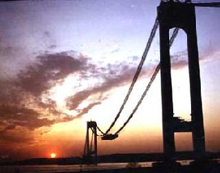
LEFT: Construction of bridge's towers and anchorages is underway in this 1962 photo. (Photo by Triborough Bridge and Tunnel Authority.) RIGHT: The beginning of deck installation is shown in this 1963 sunset photo. (Photo by Slattery-Swanska USA.)
DESIGN AND CONSTRUCTION: The TBTA awarded the job of designing the Verrazano-Narrows Bridge to Othmar Ammann, the foremost American bridge designer of the 20th century. In New York City, Ammann had previously designed the Triborough, Bronx-Whitestone, Throgs Neck, George Washington and Bayonne bridges. Construction of the Verrazano-Narrows Bridge, which was to be Ammann's final project, began on August 13, 1959.
When the federal government originally granted permission to construct the bridge, the bridge would have had a main span of 4,620 feet. After negotiations with the Army to obtain land, it was possible for engineers to shorten the length of the main span by 360 feet to 4,260 feet, and to shorten the two side spans by 185 feet to 1,215 feet. The Army Corps of Engineers required that the bridge have a clearance of 180 feet at the towers, and of 216 feet at the towers. By using a four percent grade on the approaches and side spans, and by gracefully curving the main deck, a mid-span clearance of 228 feet was obtained. Between anchorages, the length of the span was to be 6,690 feet. Including approaches, the length of the bridge was to be 13,700 feet.
The foundations, which support the 264,000-ton weight of both the towers and the suspended deck, as well as a design live load of 16,000 tons on the deck, were dug 105 feet below the water on the Staten Island side, and 170 feet below the water on the Brooklyn side. Conventional foundation design called for sand islands that kept water, as well as provided working and storage space. However, because the currents were swift and the ground was unstable in the area, sand islands were not constructed. Instead, "cofferdams," or vertically interlocking steel sheet pilings, were driven below the surface to protect the caissons. Above each 13-foot-high caisson base, muck and sand were dredged out of 66 vertical concrete shafts. When the caissons reached their predetermined depth, the shafts were filled with water, and caisson tops and bottoms were sealed with concrete. The two tower piers, which contain a combined 196,500 cubic yards of concrete, were completed in less than two years at a cost of $16.5 million.
Two anchorages were then constructed at either end of the Narrows. Each anchorage stands 130 feet high, 160 feet wide and 300 feet long. However, because of the differences below ground, the Brooklyn anchorage contains 207,000 cubic yards of concrete, while the Staten Island anchorage contains only 171,000 cubic yards of concrete. On their inshore ends, they support the two decks of bridge approaches. On their outshore ends, they carry four massive, roller-mounted saddles that support, and move with, the four cables as they change length, either because of temperature changes or because of load changes. The hand-polished concrete exteriors have diagonal patterns that continue the path of the suspension cables. Inside the anchorages, forces from the suspension are transferred at two points: the front of the anchorage (where the compacted cables bend around saddles that rest on inclined steel posts), and near the heel of the anchorage (where eyebars transfer force to inclined girders buried within the concrete). The anchorages cost $18 million to construct.
Much of 1962 was spent constructing the two towers. Made up of 26,000 tons of steel, the two 693-foot towers support the four cables, and by doing so, transfer the weight of the 81,000-ton suspended structure through their foundations to the earth below. Because the center span of a suspension bridge is heavier than its side spans, erection of the center span causes the tower tops to lean slightly toward each other. On most suspension bridges, the tower tops are pulled apart before they are loaded, and tied back by the estimated amount of the inward tilt. In the case of the Verrazano-Narrows Bridge, however, the towers were not pulled apart. On five separate occasions when the inward tilt of the towers was as great as the engineers deemed permissible, the towers were uprighted. When the towers are perfectly upright, the tops of the towers were designed to be 1 5/8 inches further apart from their bases. The towers are so high and so far apart that compensation for the curvature of the earth results in this difference. Little more than one year later, the towers were completed at a cost of $46 million.
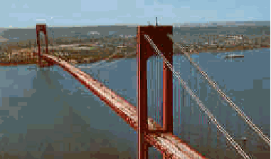
The Verrazano-Narrows Bridge nears completion in this 1964 photo. (Photo by Bridgepros.com.)
THE FINISHING TOUCHES: The spinning of the four main cables took place between March and August of 1963. Each of the four cables, which measure 7,205 feet long and 36 inches in diameter, consists of 61 strands of 428 wires apiece. Every one of the 26,108 wires (which measure 0.196 inch in diameter) that comprise each cable - totaling 143,000 miles in length - was tested for size, strength, finish and metallic content. In a process little changed since John Roebling, the cables were carried from anchorage to anchorage on a wheel that lays them side-by-side, and one above the other. Temporary footbridges, or catwalks, were constructed so that the workmen could work on the cables. This part of the project was completed at cost of $57 million and three lives.
The final phase of construction - the installation of the deck - began in October 1963. The 81,000-ton deck featured a conventional design with vertical stiffening trusses and lateral braces. From an engineering standpoint, the double decking of the Verrazano-Narrows Bridge permitted not only adequate traffic service, but also the depth necessary for rigidity of the deck. It also allowed for temperature changes: between the summer and winter months, the elevation of the deck above the Narrows can vary by as much as 12 feet. The framework of the deck is comprised of 75 elongated "boxes" measuring 115 feet wide and 27 feet deep. All but four of the "boxes" were assembled on the ground and hoisted as much as 200 feet above the Narrows.
On virtually every suspension bridge built in the United States until that time, erection of the deck began at the towers and proceeded toward mid-span and the anchorages. In the case of the Verrazano-Narrows Bridge, the contractors first hoisted the "keystone piece" at mid-span, then proceeded toward the anchorages. This method kept the towers as erect as possible while preventing distorting of the cables. Once the deck was completed, 960,000 feet of concrete roadway was installed. This part of the project cost $37 million.
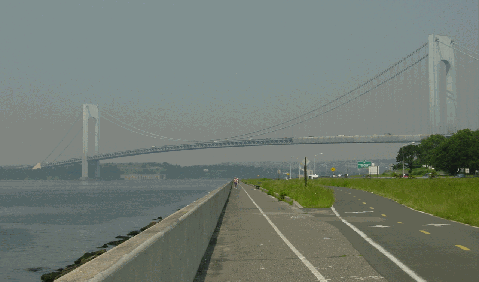
This 2003 photo shows the Verrazano-Narrows Bridge from the Dyker Heights shoreline. The Belt Parkway bike-pedestrian trail is shown in the foreground. (Photo by Jim K. Georges.)
THE BRIDGE OPENS: From The Great Bridge:
So much for the steel and concrete: the bridge is more; it is the fruition of the dreams of men who for generations have imagined spanning the choppy waters of New York Harbor to provide a solid link between Staten Island and the other four boroughs of New York. In spite of political affiliations the island has always had closer physical ties to New Jersey than to its own state, mainly because the waters separating it from New Jersey are much narrower and less treacherous than those separating it from New York.
The Verrazano-Narrows Bridge opened on November 21, 1964, at a cost of $320.1 million. The six-lane upper deck was opened to traffic, while the six-lane lower deck was reserved for future use. Moses spoke of the completed project, "These gigantic, suspended rainbow arches of steel and stone are surely evidence of Divine inspiration."
Some 12,000 men worked on the bridge; about 1,000 men worked on site during the construction schedule's peak. The construction workers consisted of both local union members, most of whom were from Brooklyn Union 361 and Manhattan Union 40 with previous bridge building experience in New York, and "boomers," who were itinerant union workers and site supervisors traveling at the end of each project and moving on to the next work site, no matter the distance. Despite their heroic efforts, none of the workers were invited to the bridge's opening ceremonies.
During its first full year of operation in 1965, the six-lane Verrazano-Narrows Bridge carried approximately 48,000 vehicles per day. According to traffic projections done at that time, the lower deck was to open in 1975. However, increased traffic accelerated the opening of the lower deck to June 1969. Each deck carries three westbound lanes and three eastbound lanes of I-278.
IMPACTS ON BROOKLYN AND STATEN ISLAND: Through the community of Bay Ridge, the impact of the Verrazano-Narrows Bridge was far-reaching. To make way for the approaches, about 800 buildings were demolished, requiring the relocation of 7,000 residents. To minimize the impact, the interchange between the bridge approach and the Belt Parkway was constructed as a long loop. (Ultimately, the cancellation of the Cross Brooklyn Expressway prevented further impact to the community.) Still, the damage had been done.
The impact on the less densely populated Staten Island was more gradual. Residents who were used to their small-town ways witnessed a metamorphosis of their borough into a densely populated bedroom community, complete with condominium developments, shopping complexes and industrial parks. While the populations in the other four boroughs held steady or even declined, the population in Staten Island more than doubled in the years that followed the bridge's opening.
THE IMPLEMENTATION OF ONE-WAY TOLLS: Another impact on Staten Island was increased air pollution. In response to complaints about eastbound traffic into the Verrazano toll plaza and its effect on air quality on Staten Island, the TBTA changed the toll collection procedure on the bridge in 1986. Westbound drivers into Staten Island must pay the full toll, while eastbound drivers into Brooklyn do not pay a toll. In addition, Staten Island residents succeeded in lowering their tolls across the Verrazano-Narrows Bridge. In order to be eligible for the reduced toll, motorists must show proof of residency. Permission was granted for the lower tolls because Staten Island residents must always pay a toll whenever they leave the borough.
However, some officials are seeking a return of two-way tolls on the bridge, citing congestion, safety and air pollution concerns in Brooklyn and Manhattan resulting from motorists seeking to avoid the high one-way toll cost. In 2001, Congressman Jerold Nadler (D-Manhattan) presented legislation to have MTA Bridges and Tunnels reinstate two-way tolls, and introduce high-speed EZ-Pass lanes. Findings presented before Congress show that MTA Bridges and Tunnels loses $10 million annually as a result of the one-way tolls.
Even though no tolls are collected, the tollbooths remain standing in the eastbound direction. Because of this, eastbound motorists must slow down to 25 miles per hour through the toll plaza.
This 2003 photo shows the Verrazano-Narrows Bridge from the Bay Ridge shoreline, looking west toward Staten Island. (Photo by Jim K. Georges.)
A FIERY SCARE: On the night of June 1, 1973, two large vessels--the container ship CV Sea Witch and the tanker Esso Brussels--collided and caught fire just north of the Verrazano-Narrows Bridge. The two ships drifted south for nearly two miles before running aground at Gravesend Bay, and as the entangled vessels passed under the bridge the 200-foot-high flames from the fiery wreck nearly scorched the bottom of the lower deck. The bridge escaped with only minor damage to the paint--the upper deck was reopened within hours and the lower deck within two days--but 13 crew members on both ships lost their lives.
THE TITLE IS PASSED ON: From 1964 to 1981, the Verrazano-Narrows Bridge held the title as the world's longest suspension bridge, as measured by its main span. Since then, five other bridges have surpassed the Verrazano. Below is a list of the ten longest suspension bridges in the world, as measured by their main spans:
Akashi Kaikyo Bridge; Kobe-Naruto, Japan; completed 1998 (6,527 feet) Xihoumen Bridge; Hangzhou Bay, China; completed 2007 (5,413 feet) East Bridge, Great Belt Fixed Link; Funen-Zealand, Denmark; completed 1998 (5,326 feet) Runyang Bridge; Yangtze River, China; completed 2005 (4,888 feet) Humber Bridge; Hull, England; completed 1981 (4,625 feet) Jiangrin Bridge; Yangtze River, China; completed 1997 (4,543 feet) Tsing Ma Bridge; Hong Kong, China; completed 1997 (4,517 feet) Verrazano-Narrows Bridge; Brooklyn-Staten Island, NY; completed 1964 (4,260 feet) (tie) Golden Gate Bridge; San Francisco-Marin County, CA; completed 1937 (4,200 feet) (tie) Yangluo Bridge; Yangtze River, China; completed 2007 (4,200 feet)
MAINTAINING A GREAT BRIDGE: Even though the Verrazano-Narrows Bridge is no longer the longest suspension span, it is no less important than the others. Approximately 190,000 vehicles per day (AADT) cross over the 12 lanes of the bridge as part of the "southern bypass" around Manhattan.
In 1994, civic and environmental groups launched efforts to construct walkways for pedestrians and bicycles on the bridge. The proposal has received support from the Neighborhood Open Space Coalition, a Brooklyn-based environmental advocacy group, and Transportation Alternatives, a bicycle advocacy group. Cost estimates for installing a new walkway range from $10 million to $30 million. Charles Otey, a lawyer from Bay Ridge, Brooklyn and an advocate for the proposed walkway, described its potential benefits:
"There is no view of New York City to match the view you get from the Verrazano-Narrows Bridge. It's gorgeous. Just think if you can bike or walk or jog and you are 295 feet above the water and you're looking all the way out through Coney Island to the Atlantic Ocean or 10 miles to New Jersey. You see the Manhattan skyline, the harbor, the ships and the Statue of Liberty. It's magnificent It would attract people of all ages and races who want to be healthy. We want to bring people out here to buy houses, people who have community interest. This is a beautiful thing for a changing New York."
Recent and ongoing improvement projects on the Verrazano-Narrows Bridge are as follows:
In 1998, work began on a $40 million repainting of the bridge and its approaches. Over time, the sun has caused the original color to fade, and the salt air from the Atlantic Ocean has been harsh to the structural steel. Before is bridge is repainted, the existing lead-based paint must be removed, requiring the closure of two lanes on the lower deck to store paint (and paint removal) equipment. The 5,000,000-square-foot, "battleship gray" repainting project was completed in 2003. A three-year, $32 million follow-up project to clean and repaint the deck--mostly on the lower deck--was completed in 2008.
In 2002, MTA Bridges and Tunnels completed a $31 million rehabilitation of the anchorages and approaches. The anchorages were rehabilitated and sealed to protect the concrete structures from the elements. In addition, a new system was installed to dehumidify the anchorages, thereby preventing cable corrosion. That year, the agency also completed a $14 million project designed to bring the electrical system up to current operational standards.
MTA Bridges and Tunnels completed two studies in 2003 concerning the approaches to the bridge. On the Brooklyn shore, studies were performed on the feasibility of widening the long viaduct approach connecting the bridge to the Belt Parkway. On the Staten Island shore, studies were performed on improving the toll plaza, including the feasibility of removing the unused eastbound tollbooths.
Finally, MTA Bridges and Tunnels installed new variable message signs and traffic control devices on the bridge and its approaches.
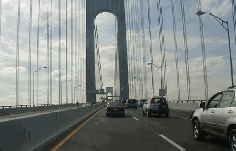
This 2001 photo shows the westbound Verrazano-Narrows Bridge (I-278) approaching the Brooklyn tower. (Photo by Mike Tantillo.)
Type of bridge: Construction started: Opened to traffic (upper deck): Opened to traffic (lower deck): Length of main span: Length of each side span: Length, anchorage to anchorage: Total length of bridge and approaches: Width of bridge: Number of decks: Number of traffic lanes: Height of towers above mean high water: Clearance at center above mean high water: Deepest foundation below mean high water: Structural steel used in approaches: Steel used in towers and suspended structure: Reinforcing steel used in entire structure: Number of cables: Diameter of each of four cables: Length of each cable: Diameter of each wire: Total number of wires per cable: Total length of wires: Concrete used in anchorages: Concrete used in tower piers: Concrete used on bridge roadway: Concrete used on approaches: Cost of original structure:
SOURCES: "Master Plan: Express Highways, Parkways and Major Streets," New York City Planning Department (1941); "Rural Staten Island View Span to Brooklyn as a Mixed Blessing" by Joseph C. Ingraham, The New York Times (1/18/1955); Joint Study of Arterial Facilities, The Port of New York Authority and the Triborough Bridge and Tunnel Authority (1955); "Staten Island Link to Sister Boroughs Is Opening Today" by Gay Talese, The New York Times (11/21/1964); The Great Bridge by Edward M. Young and Lili Rethi, Farrar-Straus and Giroux (1965); Arterial Progress 1959-1965, Triborough Bridge and Tunnel Authority (1965); "Verrazano Narrows Bridge Lower Level," Triborough Bridge and Tunnel Authority (1969); Public Works: A Dangerous Trade by Robert Moses, McGraw-Hill (1970); "Freighter Rams Tanker in Narrows, Setting Off Explosions and Fire" by Robert Thomas, Jr., The New York Times (6/02/1973); The Power Broker by Robert A. Caro, Vintage Books-Random House (1974); The Bridges of New York by Sharon Reier, Quadrant Press (1977); Great American Bridges and Dams by Donald C. Jackson, Preservation Press-John Wiley and Sons (1988); "Verrazano Bridge Hits 25, In Stride" by Merle English, Newsday (10/03/1989); "Bike Lanes on the Verrazano?" by Lynette Holloway, The New York Times (1/16/1994); "Big Dreams Span 4,260 Foot Bridge" by Merle English, Newsday (2/16/1994); Engineers of Dreams by Henry Petroski, Vintage Books-Random House (1995); "A Guide to Civil Engineering Projects in and Around New York City," American Society of Civil Engineers (1997); Bridges by Judith Dupre, Black Dog and Leventhal (1997); "Colossus to Get Sparkling New $30 Million Coat (of Gray)" by Amy Waldman, The New York Times (5/31/1998); Six Bridges: The Legacy of Othmar H. Ammann by Darl Rastorfer, Yale University Press (2000); MTA Bridges and Tunnels Facilities, MTA Bridges and Tunnels (2000); "Verrazano-Narrows Bridge Painting Is On Schedule" by Michael Wagner, The Staten Island Advance (5/06/2001); "Verrazano Bridge To Get $31.7 Million Makeover," NY1 News (2/17/2005); "Loss of Steering Led to Fiery Collision in New York's Verrazano Narrows" by John Delach, Professional Mariner (September 2007); New York Metropolitan Transportation Council; Dave Frieder; Steve Gottesman; Ralph Herman; Paul Matus; Christof Spieler; Stéphane Theroux.
Verrazano-Narrows Bridge and I-278 shields by Ralph Herman. Lightposts by Jeff Saltzman.


