

|
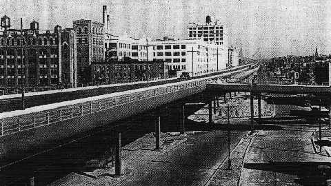
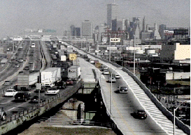
This 2002 photo shows the eastbound Gowanus Expressway (I-278) through the Sunset Park section of Brooklyn. Originally constructed atop the old Third Avenue El in the late 1930's, the expressway was widened from four to six lanes between 1958 and 1964. (Photo by Jim K. Georges.) |
||

|
"At the very moment
that we have torn down our elevated railways, because of their spoilage of urban space, our highway engineers are using vast sums of public money to restore the same nuisance in an even noisier and more insistent form. But what is Brooklyn to the highway engineer - except a place to go through rapidly, at whatever necessary sacrifice of peace and amenity by its inhabitants?" - Lewis Mumford, The New Yorker (1959) |
||
|
CONDEMNATION AND CONSTRUCTION: The Gowanus Expressway, which serves as the southern extension of the Brooklyn-Queens Expressway, also connects the Brooklyn-Battery Tunnel approach, the Prospect Expressway (NY 27), the Belt Parkway and the Verrazano-Narrows Bridge. Although guide signs and maps refer to this segment of I-278 as the Brooklyn-Queens Expressway, it is known locally as the Gowanus Expressway. |
||
|
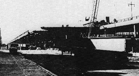
The Gowanus Parkway project, including the widened Third Avenue for local truck traffic, was completed on October 1, 1941. On August 27, 1942, the Hamilton Avenue Drawbridge, which consists of two side-by-side bascule spans over the Gowanus Canal, was opened to traffic, providing a direct connection from the northern terminus of the Gowanus Parkway to the Red Hook section of Brooklyn and points north. The twin 546-foot-long spans, which are still operated and maintained by the New York City Department of Transportation (NYCDOT), each feature a single 80-foot-leaf, and carry three lanes of traffic in each direction. When the Gowanus project opened, it was part of the "Circumferential" (Belt) Parkway that carried the NY 27A designation. |
||
|
This 1944 photo shows the elevated four-lane Gowanus Parkway above Sunset Park, Brooklyn. (Photo by Triborough Bridge and Tunnel Authority.) |
||
|
EXTENSION AND REDESIGN: In 1950, the New York City Board of Estimate approved of a six-lane, high-level viaduct over the Gowanus Canal. The viaduct was to connect the Gowanus Parkway with newer arteries such as the Brooklyn-Queens Expressway, the Brooklyn-Battery Tunnel and the Prospect Expressway. (Local traffic continues to use the Hamilton Avenue Drawbridge.) |
||

|
In 1955, both the Triborough Bridge and Tunnel Authority (TBTA) and the Federal Bureau of Public Roads (BPR) recommended that the existing Gowanus Parkway be converted to an expressway, and that the route be included in the national Interstate highway network. Two years later, the Board of Estimate approved the expansion of the existing four-lane parkway into a six-lane expressway, providing access to the proposed Verrazano-Narrows Bridge. The expansion, which was financed under the Federal-aid Interstate system (and given the designation I-278), was part of an overall plan to provide access to the proposed Verrazano-Narrows Bridge. |
||
|
Soon after the expressway conversion was approved, work began on widening the elevated section from two to three lanes in each direction, and eliminating some entrance and exit ramps. More demolition was required along the Third Avenue corridor: approximately 200 buildings were condemned for the expressway expansion. |
||
|
Further south, the newly christened "Gowanus Expressway" was extended from the western terminus of the Belt Parkway to the Verrazano-Narrows Bridge, despite vociferous protests by Bay Ridge residents. According to the Joint Study of Arterial Facilities conducted in the mid-1950's by the TBTA and the Port Authority of New York, the original plan for the Bay Ridge section called for twelve lanes in a "3-3-3-3" configuration. This was because in this section, there was to have been an interchange with the Cross Brooklyn Expressway, which was also to serve as a feeder route to the bridge. |
||
|
To address the concerns of Bay Ridge residents, the Gowanus Expressway was reduced from twelve to six lanes (three in each direction) in this area, while the Cross Brooklyn Expressway was never built. Nevertheless, some 800 buildings were torn down, and approximately 7,000 Bay Ridge residents were displaced for this eastern bridge approach. |
||
|
HOV ON THE GOWANUS: By the 1990's, the Gowanus Expressway handled approximately 175,000 vehicles per day (AADT), prompting the New York State Department of Transportation (NYSDOT) to implement HOV lanes to ease congestion. Currently, one eastbound (northbound) lane of the Gowanus Expressway is dedicated for carpools and express buses with EZ-Pass tags. |
||

|
The HOV lane, which begins at the Belt Parkway and serves traffic exclusively bound for the Brooklyn-Battery Tunnel (I-478), has so far been successful. According to a 1997 study conducted by the New York State Department of Transportation (NYSDOT), an average of 1,210 vehicles carrying 11,000 people, or 9.1 persons per vehicle, traveled in the HOV lane per hour during the morning rush. This compares with 1,625 people in 1,290 vehicles, or 1.25 persons per vehicle, in the general-use lanes per hour during the morning rush. In an effort to improve flow on the HOV lane, the NYCDOT announced plans recently to change the restriction from HOV-2 to HOV-3, meaning that vehicles now need at least three occupants to use the lane. |
||
|
Reconstruction of the Gowanus Expressway in 1959. During this project, the elevated roadway was widened from four to six lanes. (Photo by Triborough Bridge and Tunnel Authority.) |
||

|
ADDRESSING DETERIORATION AND CONGESTION: Responding to congestion and safety concerns, as well as to concerns over the structural integrity of the elevated roadway, the NYSDOT began considering options to improve the Gowanus Expressway corridor in the early 1990's. The NYSDOT sought to make the Gowanus Expressway structurally and seismically sound, increase its durability and ease of maintenance, improve traffic flow (both on the expressway and on local streets), and expand mass transit alternatives along the expressway. |
||
|
In 1994, the NYSDOT presented the following alternatives to the public: |
||
|
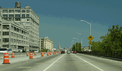
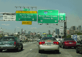
LEFT: This 1997 photo shows the eastbound Gowanus Expressway (I-278) at EXIT 24 (NY 27 / Prospect Expressway). The Lower Manhattan skyline lies ahead in the background. (Photo by New York State Department of Transportation.) RIGHT: This 2002 photo shows the eastbound Gowanus Expressway at the split for EXIT 25 (I-478 / Brooklyn-Battery Tunnel) and EXIT 26 (Hamilton Avenue), just before I-278 becomes the Brooklyn-Queens Expressway. (Photo by Jim K. Georges.) |
||
|
INTRODUCING THE GOWANUS TUNNEL: In 1997, the Regional Plan Association (RPA) released a report paid by the New York City Council indicating that a tunnel to replace the elevated Gowanus Expressway was not only technically feasible, but also desirable aesthetically to surrounding communities. The tunnel would begin at the intersection of the Gowanus Expressway, Belt Parkway and the Verrazano-Narrows Bridge approach (I-278) in Bay Ridge. The Gowanus Tunnel would continue north through Sunset Park and under the Gowanus Canal to Red Hook, terminating at the Brooklyn-Queens Expressway (I-278) and the Brooklyn-Battery Tunnel approach (I-478). |
||
|
Under the RPA plan, the increased space provided by the demolition of the elevated Gowanus Expressway would be used to develop a tree-lined boulevard along Third Avenue. Eventually, esplanades and parks would be created along the Bay Ridge, Sunset Park and Red Hook waterfronts. |
||
|
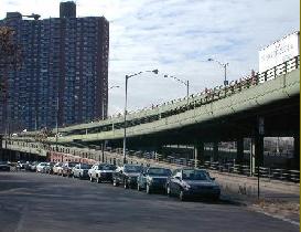
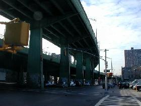
LEFT: The Gowanus Expressway at EXIT 21 (Third Avenue). RIGHT: The Gowanus Expressway at EXIT 22 (Belt Parkway). Both photos, which were taken in 2001, show the elevated expressway from street level along Third Avenue at the border of Bay Ridge and Sunset Park. (Photos by Tom Scannello.) |
||
|
THE GOWANUS TUNNEL (PRO): The Gowanus Expressway tunnel proposal has the support of some planning and transportation officials. Garry Pierre-Pierre of The New York Times explained the conclusions reached by the RPA as follows: |
||
|
In addition, a tunnel would allow the city to reclaim waterfronts in Bay Ridge and Red Hook that could be used for esplanades, parks or light-rail systems. The study cited similar projects in cities -- from Boston to Oslo -- in which congested surface or elevated roads are being replaced with tunnels. |
||
|
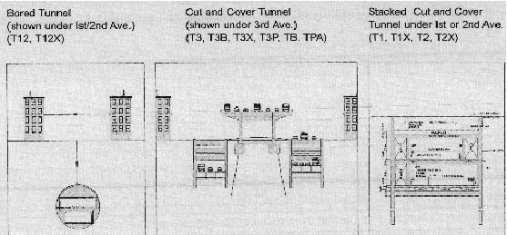
This diagram shows the possible configurations for the Gowanus Tunnel. (Diagram from "Gowanus Tunnel Project: Tier 2 Study" by New York State Department of Transportation.) |
||
|
THE GOWANUS TUNNEL (CON): However, support for the Gowanus Tunnel is not universal among transportation officials and professionals. Mark Kulewicz, director of traffic engineering and safety service at the Automobile Club of New York (the local affiliate of the AAA), responds to the RPA plan as follows: |
||
|
The last time an elevated highway collapsed in New York City, a tunnel was proposed to replace it. That proposed project -- called Westway -- never did get built, but New Yorkers remember the huge amounts of time, energy and money wasted in the attempt. |
||
|
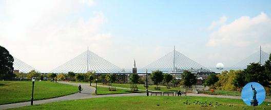
This artists' conception from 2008 shows a new elevated Gowanus viaduct with multiple cable-stay spans atop First Avenue along the Brooklyn waterfront. The existing Gowanus Expressway would be torn down and replaced with green space and multi-use paths. (Figure from American Institute of Architects, www.aia.org.) |
||

|
TIME FOR A TUNNEL: The Gowanus Expressway Tunnel proposal is one that deserves serious consideration. If the Central Artery (I-93) tunnel is indeed successful in uniting parts of Boston that had been separated when the elevated expressway was constructed, it will usher in a new era of highway construction across North America. As current urban Interstate highways reach the end of their useful lives, new expressways that are sensitive to the needs of communities and the environments should be seriously considered. |
||
|
The proposed three-tube, nine-lane Gowanus Tunnel, which would be based on the Saunders-Herrenknecht dual-deck tunnel model once planned for the Tappan Zee and Oyster Bay-Rye crossings, would run from the existing western terminus of the Belt Parkway to the Brooklyn-Battery Tunnel approach (I-478). The upper level of the outer tubes would be used for general-use traffic, while the upper level of the center tube would be used for peak-direction traffic (and may possibly be reserved for reversible HOV use). The bottom level of the tubes may be used for new subway tunnels, possibly for a future express subway line to Staten Island. Above ground, connections would be provided at EXIT 22 (Belt Parkway), EXIT 23 (38th Street), EXIT 24 (NY 27 / Prospect Expressway) and EXIT 25 (I-478 / Brooklyn-Battery Tunnel). Finally, ventilation buildings would blend into the rejuvenated neighborhoods, and parkland would be provided. |
||

|
SOURCES: New Parkways in New York City, New York City Department of Parks and Recreation (1937); "More Moses Loops Form," The New York Times (6/29/1941); Joint Study of Arterial Facilities, The Port of New York Authority and the Triborough Bridge and Tunnel Authority (1955); "Span Approaches Approved by City" by Charles G. Bennett, The New York Times (6/20/1957); "Hour Will Be Cut for Some Trips" by Joseph C. Ingraham, The New York Times (11/21/1964); Arterial Progress 1959-1965, Triborough Bridge and Tunnel Authority (1965); The Power Broker by Robert A. Caro, Vintage Books-Random House (1974); "Reconstructing the Gowanus: A Tunnel Is a Realistic Alternative to the Elevated Roadway" by Peter Herman and Albert Appleton, New York Law Journal (11/13/1996); "The Greater Brooklyn Tunnel: Thinking Big Again" by Brian Ketcham and Carolyn Konheim, Konheim and Ketcham, Incorporated (1996); "Study Backs Tunnel To Replace the Gowanus" by Garry Pierre-Pierre, The New York Times (7/01/1997); "A Tunnel We Can't Afford" by Mark Kulewicz, Car and Travel-Automobile Club of New York (February 1998); "Gowanus Expressway: Trouble Overhead" by Bernard Stamler, The New York Times (12/13/1998); "How To Build Our Way Out of Congestion" by Peter Samuel and Robert W. Poole, Jr., Reason Public Policy Institute (1999); "Study: Keep HOV Lane at Gowanus" by Bob Liff, New York Daily News (3/06/2000); "Gowanus Expressway" by Carlos Restrepo, Institute for Civil Infrastructure Systems (2000); Six Bridges: The Legacy of Othmar H. Ammann by Darl Rastorfer, Yale University Press (2000); "Gowanus Expressway Traffic Primer," New York State Department of Transportation (2001); "Gowanus Expressway Project: Tier 2 Study," New York State Department of Transportation (2002); "Gowanus Expressway Gone by 2020" by Jake Dobkin, Gothamist.com (5/04/2006);"Make Gowanus Go Away: Architects Say Ax the Highway, Build a Greenway" by Jotham Sederstrom, New York Daily News (1/06/2008); "New Plan for Getting Rid of Gowanus Expressway" by Dave Hogerty, Gothamist.com (1/06/2008); New York Metropolitan Transportation Council; Tri-State Transportation Campaign; Bernard Ente; David J. Greenberger; Ralph Herman; Guy Olsen; Jeff Saltzman; Alexander Saunders; Tom Scannello; Morris Shlyaf; Kevin Walsh; Douglas A. Willinger. |
||

|
GOWANUS EXPRESSWAY LINKS: |
||
|
GOWANUS EXPRESSWAY CURRENT CONDITIONS: |
||

|
THE EXITS OF METRO NEW YORK: |
||
|
VIEW OR SUBMIT YOUR RATING TO RATETHEROADS.COM: |
||
|
|
||

|
Back to The Roads of Metro New York home page. |
||
|
Site contents © by Eastern Roads. This is not an official site run by a government agency. Recommendations provided on this site are strictly those of the author and contributors, not of any government or corporate entity. |
||