
|
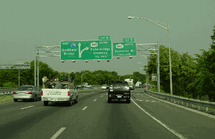
This 2002 photo shows the westbound Staten Island Expressway (I-278) at EXIT 9 (NY 440 / Dr. Martin L. King, Jr. Expressway). (Photo by Jim K. Georges.) |
||
|
PROVIDING EXPRESSWAY SERVICE FOR STATEN ISLAND: As early as the 1930's, New York City officials saw the need for an express highway that would provide local and through-traffic service through Staten Island. Unlike the Willowbrook and Richmond parkways proposed elsewhere in the borough, the new route was to allow cars, trucks and buses. All three routes were to provide access to the proposed Narrows Crossing, as well as to the existing Port Authority crossings between Staten Island and New Jersey. |
||
|
The 1941 master plan described the expressway route as follows: |
||
|
City and state officials approved the Staten Island Expressway in April 1957, paving the way for Interstate designation and the promise of 90 percent Federal funding. The expressway was designated I-278 in October 1958. For a short segment between EXIT 5 (West Shore Expressway) and EXIT 9 (Dr. Martin Luther King, Jr. Expressway), the expressway is designated as both I-278 and NY 440. |
||


|
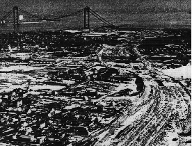
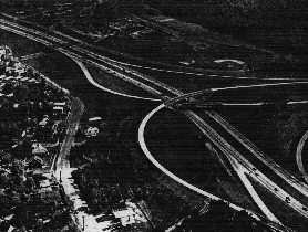
LEFT: This early 1964 aerial photo shows the Staten Island Expressway under construction near Wagner College, looking east toward the unfinished Verrazano-Narrows Bridge. RIGHT: This 1965 aerial photo shows the completed Staten Island Expressway, as shown at the interchange with the unfinished Korean War Veterans (Richmond) Parkway. (Photos by Triborough Bridge and Tunnel Authority.) |
||

|
DESIGN AND CONSTRUCTION: From the West Shore Expressway east to the Verrazano-Narrows Bridge toll plaza, the expressway was constructed with six 12-foot-wide lanes, three in each direction. A 36-foot-wide grassed center median was designed to prevent head-on collisions, as well as to accommodate an additional lane in each direction in the future. The Interstate-standard Staten Island Expressway also features a 10-foot-wide breakdown shoulder throughout its entire length. As originally planned, the expressway was to be flanked by continuous one-way service roads. |
||
|
Construction of the Staten Island Expressway took place over five years at a cost of $47 million, and required the demolition of some 400 buildings, displacing about 3,500 residents. The initial 2.4-mile-long section of expressway from the Goethals Bridge east to EXIT 9 was completed on January 30, 1964. The remaining 5.3 miles of expressway were completed on November 19, 1964, just two days before the opening of the six-lane upper deck of the Verrazano-Narrows Bridge. |
||
|
David Zarkewicz, contributor to nycroads.com, added the following about the unused Sunnyside interchange on the SIE: |
||
|
Up to two additional lanes in each direction were to be added to the Staten Island Expressway when the lower deck of the Verrazano-Narrows Bridge opened to traffic in 1969. Evidence of planned expansion to a possible quad-carriageway configuration can be found at the two underpasses at Hylan Boulevard, where right-of-way exists beyond the right shoulders. |
||
|
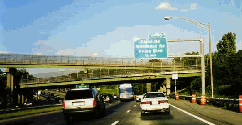
This 1998 photo shows the eastbound Staten Island Expressway (I-278), just west of EXIT 13 (Clove Road). In the background are the "ramps to nowhere" that would have connected the expressway to the unfinished portion of the Korean War Veterans (Richmond) Parkway. The unfinished interchange -- what was to be EXIT 12A -- eventually may be integrated into a proposed park-and-ride facility. (Photo by Steve Anderson.) |
||
|
According to the New York State Department of Transportation (NYSDOT), the Staten Island Expressway handles approximately 130,000 vehicles per day (AADT) through western and central parts of the island, rising to 170,000 vehicles per day near the Verrazano-Narrows Bridge. In comparison, the expressway carried approximately 50,000 vehicles per day in 1965, the first full year of operation. |
||
|
As early as 1970, the NYSDOT studied the feasibility of adding a fourth travel lane in each direction from the West Shore Expressway east to the Verrazano-Narrows Bridge, and a third travel lane from West Shore Expressway west to the Goethals Bridge. A subsequent study in 1982 estimated the cost of expansion - which would entail widening and strengthening bridges - at $25 million, 90% of which would be borne by the Federal government. The state ultimately deferred the issue of widening the expressway until the 1990's. |
||
|
In the late 1990's, the NYSDOT began building dedicated bus-only lanes that one day may extend along the length of the expressway. In December 2000, it opened these XBL lanes extending one-half mile west from the Verrazano-Narrows Bridge toll plaza. The NYSDOT extended the bi-directional bus lanes one mile west to EXIT 12 (Todt Hill Road / Slosson Avenue) in November 2005. To date, the XBL lanes cost $27 million to build. According to NYSDOT estimates, about 150 buses carrying a total of 13,000 passengers use the bus lanes. |
||

|
In 2006, the NYSDOT published a study to extend the XBL lanes in each direction west to the Goethals Bridge toll plaza. To maximize lane use while not degrading bus service, the study recommended extending usage of the lane to all passenger cars with three or more occupants (HOV 3+) for 24 hours a day, seven days a week. As with the previously built section (as well as with the Long Island Expressway HOV lanes), a 4.5-foot-wide buffer would separate the HOV lanes from general traffic, while entrance and exit would be restricted to designated points. The NYSDOT estimates it would cost an additional $113 million to extend the HOV lanes west and convert the existing bus lanes. |
||
|
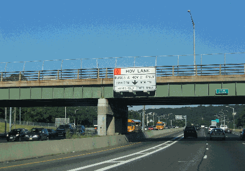
This 2008 photo shows the westbound Staten Island Expressway (I-278) at Hylan Boulevard. The wide underpasses of Hylan Boulevard were built to accommodate additional lanes between the Verrazano-Narrows Bridge and the unbuilt extension of the Korean War Veterans Parkway. Today, they accommodate the newly extended bus-only lanes, which were expanded to HOV 2+ use in the summer of 2008 as shown in this photo. (Photo by Steve Anderson.) |
||


|
HOV ON THE SIE: The newly opened bus lanes should be extended west to the Goethals Bridge. The restrictions should be modified such that vehicles with three or more occupants could use the lanes around the clock per NYSDOT recommendations. |
||

|
SOURCES: "Master Plan: Express Highways, Parkways and Major Streets," New York City Planning Department (1941); Joint Study of Arterial Facilities, The Port of New York Authority and the Triborough Bridge and Tunnel Authority (1955); "Span Approaches Approved by City" by Charles G. Bennett, The New York Times (6/20/1957); "Staten Island Link to Sister Boroughs Is Opening Today" by Gay Talese, The New York Times (11/21/1964); "Hour Will Be Cut for Some Trips" by Joseph C. Ingraham, The New York Times (11/21/1964); Arterial Progress 1959-1965, Triborough Bridge and Tunnel Authority (1965); The Power Broker by Robert A. Caro, Vintage Books-Random House (1974); "Push Is On for Varied Road Tolls," New York Daily News (11/23/1998); "State Weighs Several Fixes To Help Expressway" by Michael Wagner, The Staten Island Advance (8/01/2000); Six Bridges: The Legacy of Othmar H. Ammann by Darl Rastorfer, Yale University Press (2000); "Expressway Fix Caught in Technical Jam" by Michael Wagner, The Staten Island Advance (5/22/2001); "Staten Island Expressway Needs Big Fix" by Mary Engels, New York Daily News (4/21/2002); "Park-Ride Facility Still Has No Ride" by Michael Wagner, The Staten Island Advance (7/15/2002); "New Bus Lanes Earn Cheers, Jeers from Motorists" by Seth Solomonow, The Staten Island Advance (11/27/2005); "City Councilman Proposes Changes To Speed Up Traffic On Staten Island Expressway" by Amanda Farinacci, NY1 News (1/05/2006); "Staten Island Expressway Bus Lane / Priority Lane Study," New York State Department of Transportation (2006); "Staten Island Expressway Bus Lane Open to HOV Starting Monday," The Staten Island Advance (1/11/2008); New York Metropolitan Transportation Council; Tri-State Transportation Campaign; Hank Eisenstein; Ralph Herman; Mark Rivlin; David Zarkewicz. |
||
|
STATEN ISLAND EXPRESSWAY LINKS: |
||
|
STATEN ISLAND EXPRESSWAY CURRENT CONDITIONS: |
||

|
THE EXITS OF METRO NEW YORK: |
||
|
VIEW OR SUBMIT YOUR RATING TO RATETHEROADS.COM: |
||
|
|
||

|
Back to The Roads of Metro New York home page. |
||
|
Site contents © by Eastern Roads. This is not an official site run by a government agency. Recommendations provided on this site are strictly those of the author and contributors, not of any government or corporate entity. |
||