 |
|
|
|
|
|
|
|
|
|
|
|
|
|
|
|
|
|
|
|
|
|
|
|
|
|
|
|
|
|
|
|
|
|
|
|
|
|
|
|
|
|
|
|
|
|
|
|
|
|
|
|
|
|
|
|
|
|
|
|
|
|
|
|
|
 |
|
|
|
 |
|
|
|
|
|
IN THE PLANNING STAGES (1929-1966): What eventually became known as the Cross Brooklyn Expressway was first proposed in 1929 by the Regional Plan Association (RPA) in its report, Plan of New York and Its Environs. The proposed expressway through south-central Brooklyn was to have been part of a "metropolitan loop" connecting the radial expressways and parkways about a dozen miles from New York City Hall.
This plan was further refined in 1941 by the New York City Planning Commission in its "Master Plan: Express Highways, Parkways and Major Streets" as follows:
|
|
|
|
|
|
 |
|
|
|
|
|
|
|
|
|
|
|
|
|
|
|
|
 |
|
|
|
|
|
|
|
|
|
|
|
|
|
|
|
 |
|
|
|
|
|
|
|
|
|
|
|
|
|
Cross Brooklyn Express Highway: This is the westerly section of the middle circumferential route. It also serves as a connection between the Southern (Belt) Parkway, via the proposed Linden Boulevard Improvement, and the Brooklyn-Battery Tunnel via the Gowanus Parkway (Expressway). A route over or in the vicinity of the right-of-way of the Bay Ridge division of the Long Island Rail Road is suggested for further investigation.
In 1955, New York City arterial coordinator Robert Moses presented his postwar plan for the expressway in the Joint Study of Arterial Facilities, which was developed by the Triborough Bridge and Tunnel Authority and the Port of New York Authority. This highway, which was to begin at the intersection of the Gowanus Expressway and 65th Avenue in Bay Ridge, Brooklyn, was to provide a link for cars and commercial vehicles from the Verrazano-Narrows Bridge through central Brooklyn to the Belt Parkway and the Nassau Expressway.
However, throughout the 1950s and 1960s, Moses favored the construction of the Bushwick Expressway (I-78) before any Cross Brooklyn Expressway was to be built. Moses argued that the Bushwick proposal would provide a direct link between lower Manhattan and JFK (then Idlewild) Airport, and therefore represented a more urgent need. Upon completion of the Bushwick Expressway, the Cross Brooklyn Expressway would then be built.
In 1965, the New York City Planning Commission approved the route of the 12-mile-long expressway through southern Brooklyn. The commission presented arguments supporting the proposed Cross-Brooklyn Expressway "to close the missing southern link in the city's
outer circumferential loop around Manhattan." Henry A. Barnes, the traffic commissioner for New York City who was often at odds with Moses, backed the commission's decision.
Over the course of the planning stages, the expressway, which previously had not been part of any Federal- or state-aided highway program, was given three different Interstate route designations, the first being I-287. From the New York World-Telegraph:
|
|
|
|
|
|
|
|
|
|
|
|
|
|
|
|
|
(Barnes) explained that the expressway is proposed as a section of Interstate 287 which eventually will provide a peripheral route for commercial and passenger vehicles around the metropolitan area, linking the industrial areas of southern Brooklyn and Queens with similar areas throughout the metropolitan region, also southern New England via the proposed Long Island Sound (Oyster Bay-Rye) Bridge.
|
|
|
|
|
|
|
 |
|
|
|
|
|
|
|
|
|
|
Less clear was how the I-287 designation was to connect to the existing Interstate 287 in New Jersey to the west, or to the Seaford-Oyster Bay Expressway (NY 135 and the proposed I-287 extension) to the east.
In its 1966 report, Transportation 1985: A Regional Plan, the Tri-State Transportation Commission recommended construction of the Cross Brooklyn Expressway. It stated the purpose and benefits of the road as follows:
In New York City, several shortcomings in the regional highway system are in need of completion. First among these is the lack of a complete southern bypass route around Manhattan. Beginning at the Outerbridge Crossing, an expressway route for both cars and trucks should connect with the Verrazano-Narrows Bridge, and thence across southern Brooklyn and Queens. In Brooklyn, this route is particularly needed to serve an area of about three million people presently without any good highways, with the exception of a circuitous parkway around its perimeter that cannot be used by commercial vehicles.
|
|
|
|
|
|
|
|
|
|
|
|
Others did not agree with this proposal. In 1966, Mayor John V. Lindsay formally asked New York State to substitute the Interstate funding for the Bushwick Expressway for the Cross Brooklyn Expressway. Lindsay argued that under the Bushwick plan espoused by Moses, more peak rush-hour traffic would be sent into Manhattan. By diverting traffic away from Manhattan via the Verrazano Bridge while causing minimal displacement of homes and businesses, the Cross Brooklyn proposal was seen as more desirable by New York City officials.
|
|
|
|
|
|
|
|
|
|
|
|
|
|
|
|
|
|
|
|
|
|
|
|
|
Nevertheless, Moses argued that the Cross Brooklyn and Bushwick Expressways were both necessary. This was also the finding of a report commissioned by the Triborough Bridge and Tunnel Authority and conducted by Blauvelt Engineering.
THE 1966 PLAN: The TBTA-Blauvelt proposal called for a 17.2-mile expressway from the Gowanus Expressway approach to the Verrazano Bridge to Sunrise Highway (NY 27) at the Queens-Nassau border. The Cross Brooklyn Expressway was to continue east into Nassau County as the Atlantic Expressway, which was to be built along the rights-of-way of Sunrise Highway and the LIRR Montauk branch. The Atlantic Expressway was not covered in this report.
The Cross Brooklyn Expressway was to have eight lanes between the Verrazano Bridge approach and Nostrand-Flatbush Avenues, and six lanes east to the Queens-Nassau border. Interchanges were to be provided at the Gowanus Expressway, Fort Hamilton Parkway, New Utrecht Avenue, Nostrand-Flatbush Avenues, Ralph Avenue, Pennsylvania Avenue, Belt Parkway (westbound), Cross Bay Boulevard, Bushwick Expressway, Nassau Expressway, Van Wyck Expressway, Belt Parkway (eastbound), Rockaway Boulevard, Clearview Expressway and Sunrise Highway.
RECOMMENDED CONSTRUCTION FOR THE TBTA-BLAUVELT PLAN: The 15 sections of the Cross Brooklyn Expressway was to be constructed as follows:
SECTION 1 (viaduct from Ovington Avenue to 12th Avenue)
The construction from the Verrazano-Narrows Bridge approach to Ovington Avenue would be depressed, conforming to the plans developed by the TBTA for the ultimate expressway development when the lower deck is opened on the bridge. Beginning at Ovington Avenue, the connections to the Cross Brooklyn Expressway would climb from the depressed approaches and pass over the intersection of 7th Avenue and 65th Street. Viaduct construction would be used as the expressway would turn easterly, cross the Sea Beach and Long Island Rail Road tracks, and occupy a position north of the railroad. Between Fort Hamilton Parkway and 12th Avenue, the expressway would descend to the railroad grade at 12th Avenue. The depressed eight-lane roadway, in a position north of the two existing LIRR tracks that would be retained, would not interfere with the Sea Beach tracks that would remain south of the railroad. Property acquisition would be required between 65th Street and 62nd Street, and on the north side of 61st Street from 9th Avenue easterly to 12th Avenue.
SECTION 2 (depressed expressway from 12th Avenue to Albany Avenue)
Proceeding easterly at New Utrecht Avenue, the expressway would pass under the West End Division's elevated tracks and the surface streets. At McDonald Avenue, the IND Coney Island's tracks would be similarly treated. Underpinning will permit uninterrupted service on the lines during construction. From New Utrecht Avenue east to Nostrand Avenue, the depressed roadway would lie north of the railroad, requiring a substantial relocation of the LIRR and a petroleum products distribution site. To accommodate the expressway and railroad, property acquisition would be required on the north side of 61st Street and the railroad from 12th Avenue to just west of Ocean Parkway, and on the south side of the railroad from McDonald Avenue to Nostrand Avenue. At Nostrand Avenue, the eight-lane construction would end, and six lanes would be provided easterly of this point. From Nostrand Avenue to Brooklyn Avenue, the six-lane expressway would pass through an area restricted on both sides by substantial existing and proposed buildings. There is a proposed municipal parking garage and playground between Nostrand Avenue and Flatbush Avenue. The construction plans of the proposed garage indicate that the suth wall of the garage will be on the railroad right-of-way, and that a playground deck will cover the right-of-way from Nostrand Avenue to Flatbush Avenue. Just east of Flatbush Avenue, there is an existing shopping center parking lot utilizing the air rights over the LIRR right-of-way. The right-of-way at this point is 75 feet wide, in line with the property line of six-story apartments on the north side, and the south side of the right-of-way is against the property line of a 20-story apartment building. By careful positioning of the line, the depressed expressway and relocated railroad with a combined width of 121 feet would pass through this area without undercutting the apartment buildings. The proposed municipal parking garage poses a problem. Our alignment studies lead to the conclusion that the south edge of the building as proposed would be undercut by the expressway. The proposed construction would have to be altered to accommodate the expressway. Property acquisition would be required on both sides of the railroad in the area from Nostrand Avenue to Albany Avenue.
SECTION 3 (transition from depressed expressway to viaduct over railroad, from Albany Avenue to Glenwood Road)
From Albany Avenue to Glenwood Road, the depressed expressway would rise to cross over the street system and ultimately rise to one level above the railroad, or two levels above the street system.
SECTION 4 (viaduct over railroad from Glenwood Road to Van Sinderen Avenue)
From Glenwood Road to Van Sinderen Avenue, except in the vicinity of Ralph Avenue, the expressway would be positioned over the railroad, which is over the street system and within the railroad right-of-way. In the interchange area at Ralph Avenue, the expressway would be moved south of the railroad and lowered to one level above the streets to avoid the very long ramps required if the expressway were continued through the interchange two levels above the street system.
SECTION 5 (viaduct and walled fill from Van Sinderen Avenue to Flatlands Avenue)
As the route leaves the railroad right-of-way, viaduct construction would be continued to cross the Canarsie subway line. A two-level-high viaduct may permit aerial easement acquisition in the Flatlands Industrial Site. But as soon as possible, the expressway would be lowered to walled fill, one level above the street system.
SECTION 6 (low embankment along Flatlands Avenue from Schenck Avenue to Fountain Avenue)
Recommended construction in this area would set the center line of the expressway as far south of the high rise building development as possible. Parts of the existing and proposed portions of Flatlands Avenue on the north would be partially retained as a one-way service road. A new eastbound service road would be constructed on the south. To keep the expressway as unobtrusive as possible, it would be kept relatively low, and suitable landscape screening would be provided between the service road and the expressway to shield the housing developments.
SECTION 7 (structure at-grade on embankment, from Fountain Avenue to Belt Parkway)
After the expressway crosses Fountain Avenue it would be kept low. Field inspection in this area indicates the possibility of poor subsurface conditions, so from a conservative cost outlook we have estimated the cost of this segment of the route based on the assumption that substantial portions would be built at-grade.
SECTION 8 (viaduct from Belt Parkway to Cross Bay Boulevard)
Since the expressway must cross over Belt Parkway, over 84th Street at the beginning of this section, and over Cross Bay Boulevard approximately 2,000 feet to the east, there would be insufficient distance between over-crossings to lower the expressway to grade between them while maintaining vertical sight distances required for a 60 MPH design speed.
SECTION 9 (transition from viaduct at Cross Bay Boulevard to expressway at-grade at the IND Rockaway Division)
By going over Cross Bay Boulevard, the construction as proposed would leave the Belt Parkway-Cross Bay Boulevard interchange intact. Only a minor relocation would be required in the southeast quadrant of the interchange. A direct connection would be constructed from the eastbound Bushwick Expressway-Nassau Expressway to the eastbound Cross Brooklyn Expressway in that quadrant. Using a four percent grade just east of Cross Bay Boulevard, the proposed construction would descend from viaduct to expressway at-grade to pass under a new Cohancy Street overpass. The effective length of four percent grade would be approximately 800 feet. The new Cohancy Street overpass would be at the same elevation as the Cohancy Street overpass proposed in the Nassau Expressway construction. The recommended construction would proceed in very shallow cut to pass under the IND Rockaway line similar to the proposed construction on the Nassau Expressway.
SECTION 10 (transition from expressway at-grade to viaduct at Lefferts Boulevard)
After passing under the subway line, the expressway would be raised to pass over Lefferts Boulevard. The expressway would be high enough to permit the existing entrance to the Aqueduct Racetrack parking lot to be used.
SECTION 11 (viaduct crossing of the Nassau Expressway and Belt Parkway just east of Lefferts Boulevard)
Recommended construction at this point would carry the Cross Brooklyn Expressway on viaduct over the Nassau Expressway, which itself is one level over Lefferts Boulevard. Between Lefferts Boulevard and 125th Street, a collector-distributor roadway would be constructed on the north side of the Nassau Expressway to provide for the interchange of traffic from the westbound Nassau Expressway to the westbound Cross Brooklyn Expressway. The eastbound movement from the Cross Brooklyn Expressway to the Nassau Expressway would be made by ramp and service road connections on the south side of the Nassau Expressway.
SECTION 12 (viaduct from 122nd Street to 150th Street)
The elevated roadways of the Cross Brooklyn Expressway would be on either side of the existing Belt Parkway. The expressway would cross over 130th Street on the middle level and the Belt Parkway on the lower level. This crossing would be on the center line of the glide path of runway 13L-31R of JFK International Airport, approximately 7,200 feet east of the runway. The expressway would be well below the 180-foot-high lower limit of the glide path. The expressway would then pass over the Van Wyck Expressway, and the complexes proposed in the Nassau Expressway construction and viaduct would continue east to 150th Street. At the Van Wyck Expressway, only two direct connections to the Cross Brooklyn Expressway would be provided as follows:
southbound Van Wyck to westbound Cross Brooklyn
eastbound Cross Brooklyn to northbound Van Wyck
The remaining movements would be possible by indirect connections provided in the interchange complex as it is now being built.
SECTION 13 (viaduct, at-grade construction and parkway reconstruction from 150th Street to Farmers Boulevard)
By partially reconstructing the Belt Parkway and shifting it to the north in its corridor, there would be enough room in the corridor for both the parkway and the expressway. About one-half of this segment would be constructed as expressway at-grade on either side of the reconstructed Belt Parkway.
SECTION 14 (expressway at-grade from Farmers Boulevard to 225th Street)
In the vicinity of any southerly extension of the Clearview Expressway, at-grade construction would reduce the height of the interchange at this connection. At the proposed Clearview Expressway extension, only two direct connections would be provided:
southbound Clearview to eastbound Cross Brooklyn
westbound Cross Brooklyn to northbound Clearview
Other traffic movements would be made via the proposed Nassau Expressway-Clearview Expressway interchange to the south of the Cross Brooklyn Expressway-Belt Parkway corridor.
SECTION 15 (viaduct construction from 225th Street to Hook Creek Boulevard at the Queens-Nassau line)
Around 230th Street, the LIRR enters the corridor between North Conduit Avenue and South Conduit Avenue with a resulting restriction in the width of the corridor available for highway use. By elevating the expressway and encroaching on South Conduit Avenue, the expressway would be carried through this narrow area. The interchange between the Belt Parkway and Sunrise Highway would be maintained beneath the elevated expressway. Permanent construction would end at Francis Lewis Boulevard. A temporary connection would be made to Sunrise Highway at Hook Creek Boulevard. Ultimately, the Cross Brooklyn Expressway would continue east as the Atlantic Expressway in Nassau County. The westbound lanes of the Atlantic Expressway would be carried on a viaduct north of the LIRR right-of-way, while the eastbound Atlantic Expressway would be carried on a viaduct south of the railroad.
This version of the proposed Cross Brooklyn Expressway was estimated to cost $229.2 million. Of this amount, $187.5 million was to be allocated for construction and engineering costs, while the remaining $41.7 million was to be set aside for right-of-way acquisition.
|
|
|
|
|
|
|
|
|
|
|
 |
|
|
|
|
 |
|
|
|
|
|
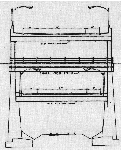
Proposed cross-section of the Cross Brooklyn Expressway over the LIRR Bay Ridge branch right-of-way. The original 1965 proposal had a two-track railroad on the lowest level, three westbound lanes on the second level, a cross-street viaduct on the third level, and three eastbound lanes on the top level. Both the eastbound and westbound carriageways featured Interstate-standard 12-foot-wide lanes, 10-foot-wide outer shoulders and 10-foot-wide inner shoulders. (Artist's rendition by New York City Department of Traffic.)
|
|
|
|
|
|
|
|
|
|
|
|
|
|
|
|
|
|
|
|
|
|
|
|
|
|
|
|
|
|
|
|
THE 1967 PLAN: The route of the Cross Brooklyn Expressway was shortened under the revised 1967 "Linear City" proposal. The expressway was to have been built from Bay Ridge to East New York via the LIRR Bay Ridge branch as in the 1966 TBTA-Blauvelt plan, but was to veer north at East New York. At this location, there would have been a massive interchange with the (unbuilt) Bushwick Expressway and the Interborough (Jackie Robinson) Parkway. North of the interchange, the Cross Brooklyn Expressway was to become the Queens Interboro Expressway. The Queens Interboro Expressway was to continue the I-695 designation northward along the New York Connecting Railroad right-of-way to the Brooklyn-Queens Expressway (I-278) in Woodside, Queens.
|
|
|
|
|
|
|
|
|
|
 |
|
|
|
|
|
THE 1969 PLAN: In 1969, plans for the Cross Brooklyn and Queens Interboro expressways were revised once again. Under this proposal, the Cross Brooklyn Expressway was to run from Bay Ridge east to the Queens Interboro Expressway (I-695) near Linden Boulevard. For about one-half mile, the Cross Brooklyn and Queens Interboro Expressways were to share the same right-of-way. At Flatlands Avenue, the Cross Brooklyn Expressway was to split off from the Queens Interboro Expressway and continue east as the Nassau Expressway Extension (I-878).
Under the 1969 plan, the Cross Brooklyn and Nassau Expressways were to complete an east-west route through Brooklyn. No provision was made for the Bushwick Expressway (I-78), which the city opposed. Since it was to continue the east-west expressway facility provided by the Nassau Expressway Extension, the Cross Brooklyn Expressway was to receive a new designation, I-878. The Federal government approved the new I-878 designation for the Cross-Brooklyn route in 1970 (the state had listed I-78 as the Cross-Brooklyn Expressway - not the Bushwick Expressway - prior to that time).
|
|
|
|
|
|
|
|
|
|
|
|
|
|
THE LINEAR CITY PROPOSAL (1967-1971): In February 1967, the Cross Brooklyn proposal would take on new dimensions. Six miles of the 10.5-mile project, from Ocean Avenue in Flatbush to Atlantic Avenue in East New York, would become part of "Linear City," an integrated community that would include the expressway, the LIRR Bay Ridge branch, housing, schools, shopping and industrial facilities.
The total cost of the project was estimated at $1.3 billion. Of this total, $1.0 billion was allocated for construction, while the remainder was to go for property acquisition and air rights, off-site costs, and the costs of services and administration. The Cross Brooklyn-Linear City project was scheduled for completion in July 1975.
In his announcement, Mayor Lindsay said that "for the first time, a highway would be a unifying force in the community." From "Linear City and the Cross Brooklyn Expressway: Plan for Planning Report:"
The overriding goal is to create, through Linear City, a totally new and prototypical urban environment. Linear City is in its philosophy an urban laboratory, radical in concept, massive in scale and embracing the five fundamental dimensions of the urban environment: its architectural form, the processes that produce this form, the life that flows within the form, the functional technology that serves this life and its public-private operation.
Although multiple uses for transportation rights-of-way were not a new concept, Linear City was seen as a vehicle to revitalize a community. Below the expressway, the LIRR Bay Ridge branch could be supplemented by passenger service. Above the expressway and its environs, at least 6,000 new housing units would be constructed. Also, an "educational park" - with multiple school facilities and anchored by Brooklyn College-CUNY - would be built to accommodate 20,000 students in grades K-12, as provide for adult education. The "educational park," through a public-private partnership, could also attract new businesses.
|
|
|
|
|
|
|
|
|
|
|
|
|
|
|
 |
|
|
|
|
|
|
|
|
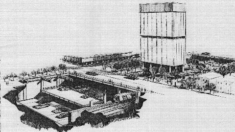
A cross-section of the proposed Cross Brooklyn Expressway / "Linear City" project, which was to have been anchored by Brooklyn College. Below street level, there was to have been two expressway decks, with each deck carrying opposing traffic flows. A dual-track subway was to have paralleled the expressway. (Artist's rendition by New York City Department of Traffic.)
|
|
|
|
|
|
|
|
|
|
|
|
|
|
|
|
|
|
|
|
THE OPPOSITION (1967-1971): The proposal went through its ups and downs for the next few years. Within months of Mayor Lindsay's Linear City announcement, opposition from the affected communities persuaded the Federal government to withhold Interstate funding for the Cross Brooklyn Expressway. From former Brooklyn legislator Stanley Steingut:
The people in Brooklyn are up in arms. We believe there are ways to have an arterial highway without dislocating the whole face of Brooklyn. The Mayor wants to run an expressway through the residential area of Brooklyn. We believe that he should sit down with some interested groups and rethink this whole matter.
|
|
|
|
|
|
|
|
|
|
|
|
|
|
By 1968, the expressway was back on the Federal highway maps, and Interstate funding was reinstated. All that was needed was approval by the New York State Legislature. The expressway passed the Republican-dominated State Senate, but failed to clear the hurdle set up by the Democratic-dominated State Assembly. Crushed by defeat, Mayor Lindsay reluctantly withdrew his plans in May 1969. On March 24, 1971, Governor Nelson Rockefeller officially de-mapped the Cross Brooklyn Expressway from New York's Interstate highway system.
In wake of the expressway's defeat, Moses replied as follows:
Since 1965, the scope of the highway project was expanded to include an extensive redevelopment program, loosely referred to as Linear City, which offered vague proposals for schools, housing, commercial buildings and industrial structures. The project was blown up to enormous proportions and the highway was lost in the shuffle. The net effect was to add new public opposition to those previously opposed to the highway to the extent that the future of the highway itself was threatened. In July 1969, as the result of neighborhood obstruction, Mayor Lindsay, with a difficult election before him, without a semblance of explanation suddenly announced that the Cross Brooklyn Expressway and Linear City were dead ducks.
RESURRECTING THE CROSS BROOKLYN EXPRESSWAY? As late as the mid-1970s, the RPA continued to advocate construction of the Cross Brooklyn Expressway, citing that existing expressways did not adequately serve central Brooklyn. (It cited a theory that desirable expressway spacing was two miles in dense urban areas.) Furthermore, the RPA recommended a "Central Brooklyn Study" that was to encompass future road and rail projects as follows:
A number of transportation improvements have been proposed for the central Brooklyn area, including subway extensions, increased use of the rail freight line, limited-access highway proposals and arterial street improvements. A comprehensive examination of these and other lower cost options is required.
The pro-expressway position was noted in a 1976 letter sent from an RPA official to nycroads.com contributor Nick Klissas. By the early 1980s, the RPA had dropped this controversial position. However, in the three decades since the Cross Brooklyn Expressway was canceled, chronic congestion along the I-278, I-495, and I-678 corridors through Brooklyn and Queens has led some planning officials to reconsider this controversial proposal to provide a new Interstate-grade facility through southern Brooklyn, probably along the Belt Parkway.
|
|
|
|
|
|
|
|
|
|
|
|
|
|
 |
|
 |
|
|
|
|
|
|
|
|
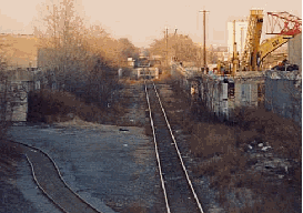
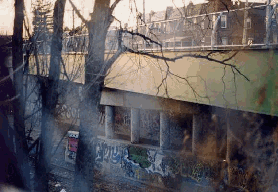
These 1998 photos show the little-used LIRR Bay Ridge branch in East Flatbush, Brooklyn. The Cross Brooklyn Expressway was to have been constructed on the railroad right-of-way. (Photos by Jeff Saltzman.)
|
|
|
|
|
|
|
|
|
|
|
|
|
|
 |
|
|
|
|
|
Of all the boroughs in New York City, Brooklyn is the least served in limited-access highway mileage vis-à-vis population. Sometime in the future, the Cross Brooklyn Expressway proposal may be resurrected as an Interstate corridor for use by passenger cars and commercial traffic.
The new Cross Brooklyn Expressway should utilize the right-of-way along Conduit Boulevard, Linden Boulevard and the LIRR Bay Ridge branch to the Gowanus Expressway (I-278). This project should be done in conjunction with the conversion (and completion) of the Nassau Expressway into a controlled-access facility, and possibly be integrated with the long-proposed plan for a rail tunnel between Bay Ridge, Brooklyn and Bayonne, New Jersey. Strong consideration should be given to its construction as a tunnel facility.
|
|
|
|
|
|
|
|
|
|
|
|
|
|
|
|
|
|
|
|
|
More from nycroads.com and misc.transport.road contributor Douglas A. Willinger as follows:
If New York City planning were more comprehensive with pursuing environmentally advanced designs for projects combining highways and rail, the discussion for this much needed Cross Bay Rail Tunnel to Brooklyn would include a vehicular link to New Jersey, with an eastern extension across Brooklyn to Kennedy Airport.
Like the Cross Brooklyn Expressway proposals of the 1960s, this would employ the right of way of the LIRR freight tracks. Unlike these earlier proposals, this new highway would be designed to not tower over neighborhoods, nor take lengthy swaths from existing neighborhoods, nor increase localized air pollution, nor even be something that could accurately be said as dividing Brooklyn locally. Rather than building a high viaduct over the railroad, or a below ground roadway lined with new buildings (at the expense of homes), build this Cross Brooklyn Expressway as an encased, multi-level, multi-model road tunnel with electrostatic precipitator filtration technology, built beneath a new linear park for much of its length.
This railroad corridor is wide at its western segment, approximately 250 feet wide with a single rail track, and its eastern segment traverses vast industrial areas. In contrast, the middle segment is rather narrow, about 50 feet wide, and is immediately abutted by residential areas that may not permit widening. Indeed, this width is too narrow for a conventional expressway layout, thus requiring a multi-level underground facility. This would perhaps entail three separate decks, one deck for expanded passenger and freight rail service, and two decks for each expressway carriageway.
Indeed, I have spoken with someone originally from this part of Brooklyn who opposed the Cross Brooklyn Expressway in the late 1960s for this reason. Some 200 homes, either for this middle segment or a portion of it, would have been taken for that proposal. Nevertheless, he does see the Cross Brooklyn Expressway as a much-needed road that should be pursued in a way that would not take these houses.
The combined Cross Brooklyn-Nassau Expressway facility should become the new I-878, creating a much-needed, east-west truck corridor serving southern Brooklyn, southern Queens and Kennedy Airport.
However, nycroads.com contributor Ralph Herman provided the following counterpoint, arguing instead in favor of an expanded Belt Parkway:
I believe that attempting to put a "Cross Brooklyn Expressway" through the existing Brooklyn railroad freight line will not fly, because of the narrow right-of-way through older established Brooklyn residential neighborhoods, and any proposed construction will be fought in court by environmentalists, mass transit advocates, and residents along the right-of-way. Even if the Cross Brooklyn Expressway project were finally approved, it would cost billions of dollars. Also, the west end of the Cross Brooklyn would have to connect to something, either to I-278 (Gowanus Expressway), which is already carrying traffic over its original design capacity, or a new bridge and/or tunnel across Upper New York Bay to New Jersey. The new crossing would cost additional billions of dollars.
|
|
|
|
|
|
|
|
|
 |
|
|
|
|
|
|
|
|
|
 |
|
|
|
 |
|
|
|
|
|
SOURCES: "Master Plan: Express Highways, Parkways and Major Streets," New York City Planning Commission (1941); Joint Study of Arterial Facilities, The Port of New York Authority and the Triborough Bridge and Tunnel Authority (1955); "Expressway Plans," Regional Plan Association News (May 1964); "Road in Brooklyn Called Essential," The New York Times (3/02/1965); "Barnes Backs Ballard on New Expressway," The New York Times (7/08/1965); "Barnes Backs Cross-Brooklyn Road," New York World-Telegraph (7/08/1965); "Barnes Gives Plan for an Expressway Crossing Brooklyn," The New York Times (9/16/1965); "Cross Brooklyn Expressway," New York City Department of Traffic (1965); Arterial Progress 1959-1965, Triborough Bridge and Tunnel Authority (1965); "Four of Moses' Roads Get City Priority" by Joseph C. Ingraham, The New York Times (7/14/1966); "Lindsay Asks State To Accept a Cross Brooklyn Expressway" by Charles G. Bennett, The New York Times (9/14/1966); "Cross Brooklyn Expressway Route Selection Study," Triborough Bridge and Tunnel Authority (1966); Transportation 1985: A Regional Plan, Tri-State Transportation Commission (1966); "Linear City and Cross Brooklyn Expressway: Plan for Planning Report," Rogers, Taliaferro, Kostritsky and Lamb (1967); "Cross Brooklyn Expressway: Benefits for Brooklyn," New York City Department of Traffic (1967); "US Agrees To Aid Lindsay Proposal for Linear City" by Richard Madden, The New York Times (6/29/1968); Joint Development and Multiple Use of Transportation Rights of Way, Highway Research Board (1968); "Highway Plans Halted by Mayor" by Maurice Carroll, The New York Times (5/04/1969); "Description of Touring Routes in New York State for the Interstate, Federal, and State Route Number Systems," New York State Department of Transportation (1970); Public Works: A Dangerous Trade by Robert Moses, McGraw-Hill (1970); "Lower Manhattan Road Killed Under State Plan" by Francis X. Clines, The New York Times (3/25/1971); How To Save Urban America by William A. Caldwell, Regional Plan Association-Signet Books (1973); "Queens Interborough Expressway: Planning Report," Vollmer Associates (1973); Maintaining Mobility, Tri-State Regional Planning Commission (1975); "Highway Hopes That Faded by Sidney C. Schaer, Newsday (11/05/1999); "NYMTC Regional Freight Plan," New York Metropolitan Transportation Council (2001); David Golub; David J. Greenberger; Chris Helms; Ralph Herman; Nick Klissas; Jeff Saltzman; Alexander Saunders; Tom Scannello; Douglas A. Willinger.
I-878 and I-287 shields by Ralph Herman.
Lightposts by Jeff Saltzman.
|
|
|
|
|
|
|
|
|
|
|
|
|
|
|
|
 |
|
|
|
|
|
|
|
|
|
 |
|
|
|
|
|
|
|
|
 |
|
|
|
|
|
|
|
|
|
|
|
|
Site contents © by Eastern Roads. This is not an official site run by a government agency. Recommendations provided on this site are strictly those of the author and contributors, not of any government or corporate entity.
|
|
|
|
|
|
|
|
|
|