

|
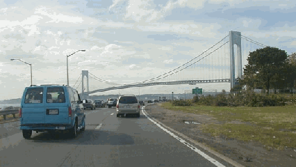
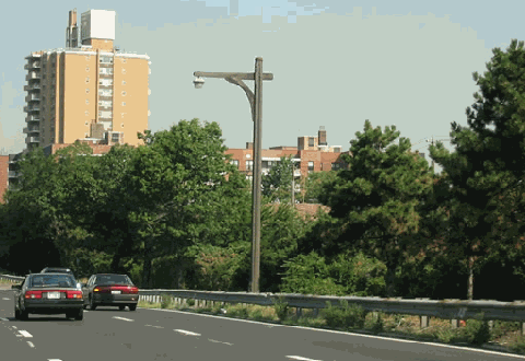
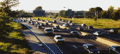
This 2001 photo shows the westbound Belt Parkway approaching EXIT 3 (I-278 / Verrazano-Narrows Bridge) in Dyker Heights, Brooklyn. (Photo by Mike Tantillo.) |
||

|
DEVELOPING THE BELT PARKWAY: On February 25, 1930, before a crowd of 500 civic leaders, Robert Moses articulated his plans for limited-access arterial routes within New York City. Among the planned routes was a "Marginal Boulevard" (later called the Circumferential Parkway, and finally the Belt Parkway) that would provide quick access from along the shorefront of southern Brooklyn and Queens. It would be part of a long-sought plan to provide limited-access from Manhattan to the Long Island and Westchester parkways. |
||
|
Along the route of the Belt Parkway, Moses planned a series of "ribbon parks" similar to those found on the Long Island parkways. Wherever possible, playgrounds and walkways were to be constructed along the parkway right-of-way. Moses believed that landscaped, controlled-access parkways would provide for not only efficient traffic flow, but also development of desirable residential growth. Obtaining this land would be easy, since most of it was still undeveloped. |
||
|
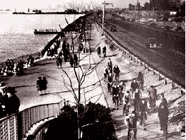
This 1940 photo shows the Belt Parkway through the Bay Ridge section of Brooklyn. One of the most ambitious of the pre-war parkways built in New York City, the Belt Parkway is lined with waterfront promenades, bicycle paths, playgrounds and large parks. (Photo by Max Ulrich - New York City Department of Parks and Recreation Archive.) |
||
|
DESIGN AND CONSTRUCTION: Construction of the 36-mile-long Belt Parkway, which included the 11 ½-mile-long Cross Island Parkway, began in 1934. During construction of the parkway in the late 1930's, highway design advances that had been tested on the Long Island parkways - most notably the dark-colored main roadways and light-colored entrance and exit ramps - were applied on the Belt Parkway. New sodium vapor light fixtures were installed atop the traditional timber lightposts. |
||
|
On the entire Belt-Cross Island route, a total of 47 road bridges, six pedestrian overpasses, five railroad bridges and six over-water crossings were constructed. Most noteworthy were the 2,740-foot-long viaduct over the Coney Island subway yards and the Mill Basin drawbridge. The parkway skirts 26 park areas totaling more than 3,500 acres, including Owl's Head Park, Dyker Beach Park and Golf Course, Marine Park and Canarsie Beach Park. Gasoline stations were constructed at Bay Ridge and Marine Park (the Bay Ridge stations have since been torn down). A police precinct house was also constructed at Marine Park. |
||
|
The following dimensions provide a glimpse into the ambitious parkway project: |
||
|
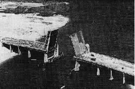
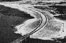
LEFT: The finishing touches are being applied to the Mill Basin Drawbridge along the Belt Parkway in 1940. RIGHT: This 1940 aerial view shows the Belt Parkway from the Plum Beach Channel bridge east to Flatbush Avenue in Marine Park. (Photo by Triborough Bridge and Tunnel Authority.) |
||
|
NAMES AND DESIGNATIONS: The sections of the Belt Parkway are comprised as follows: |
||
|
Until the 1970's, each section was uniquely signed as the Shore, Southern, Laurelton and Cross Island parkways. Today, only the Cross Island Parkway is uniquely signed. The remaining segments are signed as the "Belt Parkway." Still, all exits are sequentially ordered from the Brooklyn terminus to the Whitestone Bridge approach. Over the years, the New York State Legislature has also given ceremonial names along the Belt Parkway. In 1970, the legislature named the section between Bay Ridge and Coney Island the "Leif Ericson Drive" after the Viking explorer. Nearly a quarter century later, the legislature named the section between Coney Island and Laurelton the "POW-MIA Memorial Parkway." (The "POW-MIA Memorial" designation continues east along NY 27-Sunrise Highway through Nassau and Suffolk counties.) |
||
|
From the time of its opening in 1941 until 1972, the Belt Parkway was signed as "NY 27A." In fact, as late as the mid-1980's, there was an NY 27A sign posted on one of the Belt's remaining wooden lightposts. The service roads on the section bordering JFK Airport, Conduit Avenue, have kept their NY 27 designation. (The NY 27 designation continues west into Brooklyn along Conduit Boulevard, Linden Boulevard and the Prospect Expressway.) |
||

|
WIDENING THE BELT PARKWAY: Initially constructed during the late 1930's with four 12-foot-wide lanes and a wide grassy median, the Belt Parkway allowed for later expansion to six lanes. Owing to sharp increases in postwar traffic volumes, the parkway was widened to six lanes during the late 1940's. One exception was the Laurelton Parkway section, which was widened to seven lanes (four westbound, three eastbound). A new three-lane carriageway was constructed for the eastbound lanes, while the original roadway was utilized for the four westbound lanes. |
||
|
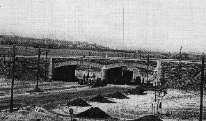
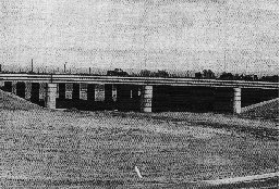
Two examples of overpass construction on the Belt Parkway at Fourth Avenue in Bay Ridge, Brooklyn (left photo) and Cross Bay Boulevard in Howard Beach, Queens (right photo). The overpass on the left reflects Moses' conventional parkway design, while the one on the right would reflect overpass design in the postwar expressway era. (Photos by Triborough Bridge and Tunnel Authority.) |
||

|
SHOULD THE BELT PARKWAY BECOME AN INTERSTATE HIGHWAY? After the cancellation of the Bushwick and Cross-Brooklyn expressways in March 1971, Governor Nelson Rockefeller announced plans for converting 15.6 miles of the Belt Parkway into an Interstate highway. The new configuration, which was to have been constructed from EXIT 3 (I-278 / Verrazano-Narrows Bridge) east to EXIT 19 (NY 878 / Nassau Expressway), was to comprise of ten lanes: six lanes for use by automobiles, flanked by two lanes in each direction for use by trucks and buses. No known Interstate designation was given to the reconstructed expressway, although it may have received the I-878 designation, since it led into the Nassau Expressway. |
||
|
The $213 million proposal received the support of the New York City Office of Arterial Planning, Transportation and Administration, which held that the expansion would unclog truck congestion on Brooklyn streets. However, like earlier proposals for the Cross Brooklyn and Bushwick expressways, the proposal to expand the Belt Parkway was not without its controversy. Critics labeled this plan a potential "major air pollution source to Jamaica Bay and its environs." They also held that the proposal would not benefit Brooklyn, instead benefiting truckers traveling between New Jersey and the south shore of Long Island. |
||
|
This 2002 photo shows the westbound Belt Parkway at EXIT 5 (Bay Parkway) in the Bensonhurst (Bath Beach) section of Brooklyn. The wooden lightpost is the last remaining example of the hundreds of such lightposts that adorned the Belt Parkway. (Photo by Jon Lebowitz.) |
||

|
DESIGN CHANGES: The New York City Department of Transportation (NYCDOT) maintains the Belt Parkway and the Mill Basin drawbridge, which was a 35-foot vertical clearance over mean high water and a 131-foot horizontal clearance. Surrounding rights-of-way are maintained by the New York City Parks Department. Major reconstruction work is undertaken by the New York State Department of Transportation (NYSDOT), which also installs signs and reference markers. |
||
|
The parkway has benefited from safety improvements and renovation projects, including the reconstruction of the main roadway and ramps, and the installation of new signs and lighting, in recent years. During the 1980's, the NYSDOT reconstructed the long viaduct over the Stillwell Avenue subway yard in Coney Island. That decade also saw the removal of entrance and exit ramps in southern Queens to improve safety. |
||
|
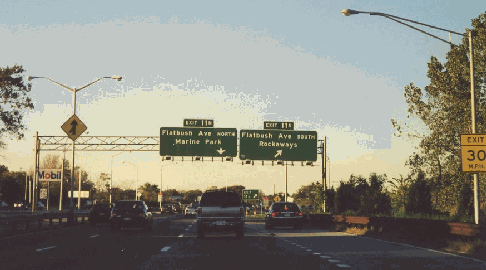
This 2000 photo shows the eastbound Belt Parkway at EXIT 11 (Flatbush Avenue) in Marine Park, Brooklyn. A Mobil service station occupies the center median of the parkway. (Photo by Steve Anderson.) |
||

|
THE BELT PARKWAY BIKEWAY AND THE ROCKAWAY GREENWAY: The Belt Parkway Bikeway, which was incorporated into the design of the parkway, opened in 1940. The section between EXIT 1 (65th Street-67th Street) in Bay Ridge and EXIT 5 (Bay Parkway) in Gravesend Bay is in relatively good condition and is heavily used. After a gap between EXIT 5 and EXIT 9 (Knapp Street) in Sheepshead Bay, there is another section that extends east to EXIT 17 (Cross Bay Boulevard) in Howard Beach. New York City plans to close the gap in the bikeway, and upgrade it between EXIT 9 and EXIT 17. |
||
|
The Belt Parkway Bikeway connects with the Rockaway Greenway, which even in its current deteriorated and interrupted state gets fairly heavy use because it accesses the Rockaway beaches, Jamaica Bay Wildlife Refuge and Floyd Bennett Field. |
||
|
This 1998 photo shows the Belt Parkway looking east at EXIT 17W (NY 27 / North Conduit Avenue) in Howard Beach, Queens. (Photo by Jeff Saltzman.) |
||

|
Ralph Herman, a frequent contributor to misc.transport.road and nycroads.com, argued that the Belt Parkway conversion and expansion proposal be revived as follows: |
||

|
SOURCES: New Parkways in New York City, New York City Department of Parks and Recreation (1937); "Belt Road To Open to Traffic Today," The New York Times (6/29/1940); "Battery Tube Loan Approved by RFC," The New York Times (6/30/1940); The Belt Parkway, New York City Department of Parks and Recreation (1940); "More Moses Loops Form," The New York Times (6/29/1941); "Road Revisions: Rock Proposal Would Kill Expressway Extensions," The Long Island Press (3/25/1971); "Brooklyn Truckway Proposal Draws Wide Opposition," The New York Times (4/25/1971); "Rockefeller Agrees To Drop Plan to Construct Truck Lanes, " The New York Times (5/21/1971); "Estimate of the Cost of Completing the National System of Defense Highways in New York," Federal Highway Administration and New York State Department of Transportation (1971); The Power Broker by Robert A. Caro, Vintage Books-Random House (1974); "Gowanus Expressway" by Carlos Restrepo, Institute for Civil Infrastructure Systems (2000); Judlau Contracting, Inc.; New York City Department of Planning; New York City Department of Transportation; New York Metropolitan Transportation Council; Regional Plan Association; Phil Case; Lyle Goldman; Ralph Herman; Nathan W. Perry; Jeff Saltzman; Steve Summers; Kevin Walsh. |
||
|
BELT PARKWAY LINKS: |
||
|
BELT PARKWAY CURRENT CONDITIONS: |
||

|
THE EXITS OF METRO NEW YORK: |
||
|
VIEW OR SUBMIT YOUR RATING TO RATETHEROADS.COM: |
||
|
|
||
|
Back to The Roads of Metro New York home page. |
||
|
Site contents © by Eastern Roads. This is not an official site run by a government agency. Recommendations provided on this site are strictly those of the author and contributors, not of any government or corporate entity. |
||