
|
|
||
|
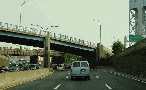
This 2002 photo shows the southbound Major Deegan Expressway (I-87) at the Grand Concourse overpass, approaching its terminus in the Mott Haven section of the Bronx. (Photo by Jim K. Georges.) |
||
|
Length: |
||
|
8.5 miles (13.7 kilometers) |
||

|
EARLY PLANS FOR THE EXPRESSWAY: In 1936, the Regional Plan Association (RPA) proposed an extensive network of expressways and parkways covering the New York-New Jersey-Connecticut metropolitan area. The expressway was to give to both pleasure and commercial traffic the type of safe and uninterrupted roadway enjoyed by pleasure vehicles on existing parkways. The RPA believed that construction of a new freeway system for all types of vehicles would be the best permanent solution for New York's traffic problems. |
||
|
One recommended route, a controlled-access expressway that was to be open to all vehicles, was to begin at the Triborough Bridge, and continue north through the Bronx to upstate New York along the eastern shore of the Hudson River. |
||
|
In 1935, New York City arterial coordinator Robert Moses began work on the initial section of the Major Deegan Expressway. This original 1.5-mile section, which connected the northern Triborough Bridge approach with Grand Concourse, was completed in April 1939, just in time for the 1939-1940 World's Fair. Like the current expressway configuration, the original configuration was six lanes, three in each direction. The original designation given to this early portion of the Major Deegan Expressway was NY 1B. |
||

|
Soon after the initial section opened, the New York City Planning Department recommended extension of the expressway to Westchester County as the "Putnam Express Highway." The route was defined as follows: |
||
|
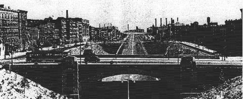
This 1939 photo shows the Major Deegan Expressway at the Willis Avenue overpass. The expressway was modernized in the 1950s when it was included in the Interstate highway system. (Photo by Bronx County Historical Society.) |
||

|
LINKING THE BRIDGE WITH THE THRUWAY: In 1945 postwar arterial plan, Moses proposed an extension of the Major Deegan Expressway north to Westchester County, where it was to connect to the proposed New York State Thruway in Yonkers. The Major Deegan Expressway, which was to connect the Bruckner Expressway (I-278) and the Cross Bronx Expressway (I-95), was considered a "relief route" to the crowded Henry Hudson Parkway and the Bronx River Parkway. |
||
|
As with his many other New York-area works, Moses worked "behind-the-scenes" to bring the Major Deegan Expressway to fruition. The following excerpt from Robert A. Caro's The Power Broker illustrated Moses' adroit negotiating skills: |
||
|
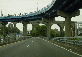
The Major Deegan Expressway was characteristic of the pre- and early-Interstate era expressways in New York City. It was designed with six 12-foot-wide lanes (three lanes in each direction) and 10-foot-wide cobblestone shoulders. The original median was comprised of a raised cobblestone curb, with "Whitestone" lightpoles placed every 75 feet. Along two separate stretches - in the area just south of High Bridge, and in the area of University Heights - the northbound and southbound lanes of the expressway were constructed at different levels to provide motorists and unobstructed view of the Harlem River. |
||
|
In 1948, the New York State Department of Public Works (NYSDPW) let out construction contracts for the Major Deegan Expressway and six other expressways in New York City. Work began in 1950 on extending the six-lane Major Deegan Expressway north along the eastern shore of the Harlem River, through Van Cortlandt Park to the Bronx-Westchester border, where the expressway was to continue north as the New York State Thruway. The project included a modernization of the original 1.5-mile section constructed in the late 1930s. |
||
|
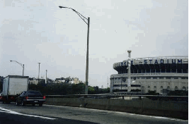
LEFT: This 1998 photo shows the northbound Major Deegan Expressway (I-87) at EXIT 5 (West 155th Street and East 153rd Street), in front of the old Yankee Stadium. (Photo by Steve Anderson.) RIGHT: This 1998 photo shows the southbound Major Deegan Expressway (I-87) at EXIT 10 (West 230th Street). (Photo by Jeff Saltzman.) |
||

|
CURRENT AND FUTURE IMPROVEMENTS: The NYSDOT and the New York Metropolitan Transportation Council have scheduled the following near-term projects on the Major Deegan Expressway: |
||
|
According to the NYSDOT, the Major Deegan Expressway handles approximately 125,000 vehicles per day (AADT). To address the demands of both motorists and communities, the NYSDOT recently initiated a "major corridor study" to improve traffic flow and aesthetics along the Major Deegan Expressway. The NYSDOT is considering the following options for the expressway:
GAS STATIONS ON THE EXPRESSWAY: Just south of the Bronx-Westchester border in Van Cortlandt Park, there is a pair of gas stations along the northbound and southbound lanes of the expressway. The gas stations, which were constructed in the early 1950's (prior to the prohibitions against roadside service stations established by the creation of the Interstate highway system), remain in operation under contract from the New York City Parks Department. EXIT NUMBERING ON I-87: The Major Deegan Expressway marks the beginning of Interstate 87, the primary north-south route from New York to Montreal. Once the Major Deegan Expressway leaves the Bronx, I-87 continues north into Westchester County as the New York State Thruway mainline. New signs erected along the northbound lanes of the Major Deegan Expressway have New York State Thruway trailblazer shields, as well as distance signs for destinations along the Thruway. Like all controlled-access highways in New York State, exit numbering on the Major Deegan Expressway is done on a sequential basis. However, the exit numbering sequence is reset once I-87 becomes the New York State Thruway. The numbering sequence is reset once again in Albany, where I-87 leaves the mainline Thruway to become the Adirondack Northway. |
||
|
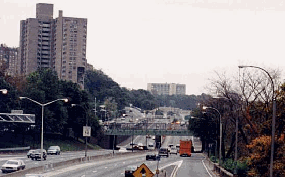
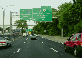
These 2002 photos show the Major Deegan Expressway (I-87) at EXIT 7 (I-95 and US 1 / Cross Bronx Expressway). LEFT: This photo shows the southbound lanes at EXIT 7. RIGHT: This photo shows the ramp connecting the Cross Bronx Expressway to the southbound Major Deegan Expressway. In the distance is the historic High Bridge, which was completed in 1848. (Photos by Jim K. Georges.) |
||

|
SOURCES: "Freeways Are Now Urged," The New York Times (12/13/1936); "Bridge Approach in the Bronx Is Ready," The New York Times (4/30/1939); "Master Plan: Express Highways, Parkways and Major Streets," New York City Planning Department (1941); "Work Begins Soon on Bronx Expressways" by Arthur Gelb, The New York Times (10/28/1948); "O'Dwyer Endorses Plans on Thruway" on Douglas Dales, The New York Times (3/07/1950); "Three Highway Links Open Tomorrow" by Joseph C. Ingraham, The New York Times (11/04/1955); "Thruway Through" by Joseph C. Ingraham, The New York Times (8/26/1956); "Splicing the Toll Road Network," The New York Times (8/26/1956); "New Bronx Link to Thruway Opens," The New York Times (11/03/1956); "Future Arterial Program for New York City," Triborough Bridge and Tunnel Authority (1963); "Ramps Emerging into Interchange," The New York Times (2/16/1964); Arterial Progress 1959-1965, Triborough Bridge and Tunnel Authority (1965); The Power Broker by Robert A. Caro, Vintage Books-Random House (1974); The Bronx: It Was Only Yesterday, 1935-1965 by Lloyd Ultan and Gary Hermalyn, The Bronx County Historical Society (1992); New York Metropolitan Transportation Council; Joel Gultz; Ralph Herman; Jeff Saltzman; Douglas A. Willinger. |
||

|
MAJOR DEEGAN EXPRESSWAY LINKS: |
||
|
MAJOR DEEGAN EXPRESSWAY CURRENT TRAFFIC MAPS: |
||
|
MAJOR DEEGAN EXPRESSWAY VIDEOS: |
||

|
THE EXITS OF METRO NEW YORK: |
||
|
|
||
|
Back to The Roads of Metro New York home page. |
||
|
Site contents © by Eastern Roads. This is not an official site run by a government agency. Recommendations provided on this site are strictly those of the author and contributors, not of any government or corporate entity. |
||