 |
|
|
|
|
|
|
|
|
|
|
|
|
|
|
|
|
|
|
|
|
|
|
|
|
|
|
|
|
|
|
|
|
|
|
|
|
|
|
|
|
|
|
|
|
|
|
|
|
|
|
|
|
|
|
|
|
|
|
|
|
|
|
|
|
|
|
|
|
|
|
|
|
|
|
|
|
|
|
|
|
|
|
|
|
|
|
|
|
|
|
 |
|
|
|
|
 |
|
 |
|
|
|
|
|
|
|
|
|
|
|
|
|
|
|
|
 |
|
|
|
|
|
|
|
|
|
|
|
|
|
|
 |
|
|
|
|
|
|
|
|
|
|
|
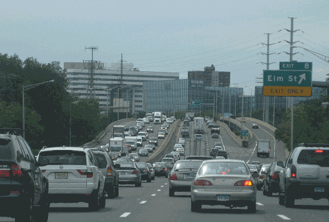
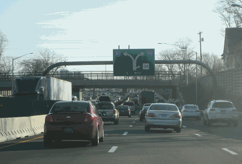
This 2013 photo shows the southbound Connecticut Turnpike (I-95) at EXIT 8 (Elm Street) in Stamford. (Photo by Steve Anderson.)
|
|
|
|
|
|
|
|
|
 |
|
|
|
|
 |
|
|
|
|
|
|
|
|
|
111.6 miles (180.0 kilometers) for entire length of I-95 in Connecticut
1940-1964
(turnpike project only, 1955-1958)
|
|
|
|
|
|
|
|
|
 |
|
|
|
|
 |
|
|
|
|
|
SOLVING THE BOTTLENECK ON THE POST ROAD: Since colonial times, the Boston Post Road had served as the main overland link between New York and Boston. Beyond serving as the main north-south artery through New England, the Boston Post Road, which was designated US 1 under the Federal Highway Act of 1921, was the main commercial street in many cities and towns along the route.
|
|
|
|
|
|
|
|
|
|
|
|
|
|
|
|
|
As more cars and trucks were registered in the 1920's, local and inter-city traffic had to compete for precious space on the two-lane road. Transportation officials tried to alleviate congestion by constructing a third lane, but often with tragic results. By the end of the decade, 25,000 vehicles per day - twice the design capacity - were using US 1 in Fairfield and New Haven counties.
To siphon traffic off the Post Road, Connecticut state highway commissioner John A. MacDonald proposed three alternatives:
further widening of the Post Road, with new bypasses constructed around major population centers
construction of a new road further inland
construction of a new road exclusively for trucks, running parallel to the Post Road and the New York-New Haven railroad
The first option was never constructed. The second option was constructed as the Merritt Parkway, a controlled-access, four-lane scenic parkway open only to passenger cars that opened in 1940. Construction of the third option, a limited-access highway open to both cars and commercial vehicles, would be postponed until after World War II.
Even as the Merritt Parkway was being constructed, officials recognized the need for a new express route that would be open to commercial vehicles. In 1936, the Regional Plan Association (RPA) recommended the construction of a regional network of expressways to supplement the existing parkway network. The new expressways were to feature the same access control features as the existing parkways, but unlike the parkways, the expressways were to be open to all vehicles. One recommended route, the precursor to today's Interstate 95, was to extend north from New York City to New Haven and Boston. It was to ease congestion on both US 1 and the Merritt Parkway.
|
|
|
|
|
|
|
|
|
|
|
|
|
|
|
|
 |
|
|
|
|
|
|
|
|
|
|
|
|
|
|
|
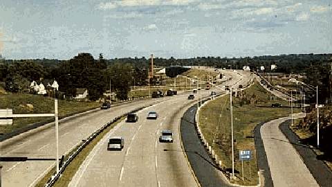
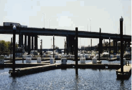
This postcard, published not long after the Connecticut Turnpike opened in 1958, shows an interchange in Fairfield County. (Postcard supplied by "T466".)
|
|
|
|
|
|
|
|
|
|
|
|
|
|
|
|
|
|
|
|
ON THE FAST TRACK TOWARD IMPROVEMENT: In 1944, President Franklin D. Roosevelt authorized the construction of a 40,000-mile system of interstate and defense highways. Most of these highways were to be improvements of the existing US highway system, with median separation of opposing lanes, grade separations of cross traffic and railroad crossings, and interchanges. Under the 1944 Federal highway legislation, the Bureau of Public Roads (BPR) selected the US 1 corridor from Maine to Florida for improvement.
|
|
|
|
|
|
|
|
|
|
|
|
|
|
Back in Connecticut, the state highway commissioner released plans for a proposed expressway from New York City to Westport. The route discussed in the 1944 state proposal was similar to that taken by I-95 today. In 1947, the state legislature directed the highway commissioner to study the need and location of routes along Long Island Sound.
Anticipating current and future traffic needs, the Connecticut Highway Department constructed US 1 Expressway bypasses in Darien (constructed 1954), West Haven (constructed 1954), East Haven (constructed 1951), Old Saybrook (constructed 1948) and New London (constructed 1943). These bypasses were eventually incorporated into the route of I-95.
|
|
|
|
|
|
|
|
|
|
|
|
THE CAPE COD EXPRESSWAY: The shoreline route was adopted in another multi-state proposal. In 1953, the governors of New York, Connecticut, Rhode Island and Massachusetts convened to support plans for a 260-mile-long expressway to link New York City with Provincetown, Massachusetts, at the eastern tip of Cape Cod. The $75 million, four-to-six lane highway, parts of which were to be tolled, was to be "the most direct and shortest highway route between the present and potentially major urban-industrial and recreational concentrations, and between significant military installations of the shore route area."
|
|
|
|
|
|
|
|
|
|
|
|
|
|
|
|
|
|
|
|
|
In addition to the current route of I-95 through Connecticut, the route of the "Cape Cod Expressway" would have continued along RI 138, RI 24, I-195 and US 6. With the exception of parts of the RI 138 and RI 24 expressways (which was to be included in a later I-895 proposal), much of the route was eventually built.
|
|
|
|
|
|
|
|
|
|
|
|
|
|
 |
|
 |
|
|
|
|
|
|
|
|
|
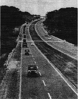
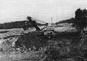
LEFT: This 1961 photo shows New Hampshire National Guard vehicles traveling on the Connecticut Turnpike (I-95) near EXIT 63 (CT 81) in Clinton. TOP: This 1963 photo shows I-95 under construction in Waterford, just east of I-395. (Photos by Connecticut Highway Department.)
|
|
|
|
|
|
|
|
|
|
|
|
|
|
|
|
|
|
|
|
|
|
CONSTRUCTION OF THE TURNPIKE: In 1954, the Connecticut state legislature authorized construction of the "Greenwich-Killingly Expressway," a 129-mile-long, controlled-access toll superhighway along the US 1 corridor connecting the New York metropolitan area with Rhode Island. The route was to run east-northeast along Long Island Sound from Greenwich to East Lyme (the route of today's I-95), then northeast to Killingly (the route of today's I-395 and CT 695).
|
|
|
|
|
|
|
|
|
|
|
|
|
|
The 1954 legislation enabled the State Highway Commission to issue construction bonds, which would be covered by tolls and other income. Construction of the superhighway, began on January 17, 1955 in three separate locations: Norwalk, West Haven and Old Saybrook. By then, the highway had a new name: the Connecticut Turnpike.
The Connecticut Turnpike was the most significant public works project in the post-war era. To coordinate work on the turnpike, the State Highway Commission created a special unit in the engineering division. Designers from 26 outside engineering firms assisted highway engineers from the State Highway Commission.
The slow process of acquiring rights-of-way dictated the pattern for designing and constructing the Connecticut Turnpike. Unable to build substantial sections of highway at one time, contractors would build one small section before moving on to another one. The turnpike project comprised of 45 smaller projects in 1956, and 78 smaller projects in 1957; it also integrated several short bypasses previously constructed.
Engineered for a design speed of 60 miles per hour, the Connecticut Turnpike was constructed with six lanes from the New York State border to East Haven, and with four lanes between East Haven and Killingly. With local exceptions, the same design remains today. Like most of the pre-Interstate era turnpikes, steel guardrails on a narrow median separated the two carriageways. (The guardrails have since been replaced with concrete "Jersey" barriers.) The turnpike was built with a design capacity of 90,000 to 115,000 vehicles (AADT) on its six-lane sections, and a design capacity of 50,000 vehicles on its four lane sections.
The original turnpike exit and destination signs featured white lettering on a blue background, a standard that had been adopted earlier on the New York State Thruway. These pre-MUTCD signs, most of which were attached to slim steel gantries, remained on the turnpike well into the 1980s.
|
|
|
|
|
|
|
|
|
|
|
|
|
|
 |
|
 |
|
|
|
|
|
|
|
|
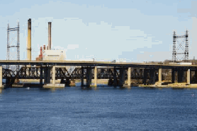
Two turnpike bridges are shown in these 1999 photos. LEFT: The Connecticut Turnpike over the Mianus River in Greenwich. The 1983 bridge collapse at the site focused attention on the state of the nation's infrastructure. RIGHT: The Connecticut Turnpike bridge over the Housatonic River connects the towns of Stratford and Milford. This bridge was rebuilt in 2013-2014. (Photos by Steve Anderson.)
|
|
|
|
|
|
|
|
|
|
|
|
|
|
|
|
|
|
|
|
A NEW ROUTE FROM THE BRONX TO RHODE ISLAND: On January 2, 1958, all but three miles of the Connecticut Turnpike were formally opened to traffic by Governor Abraham Ribicoff. At a ceremony held before six former governors, Governor Ribicoff hailed the turnpike as a great construction achievement:
The most modern highway construction methods contributing to safe driving have been engineering into this road. Now it is up to the public to use proper care in driving so that accidents can be kept to a minimum.
|
|
|
|
|
|
|
|
|
|
|
|
|
|
In October 1958, the western three miles of the turnpike connecting the Stamford area with the New England Thruway, including bridges over the Mianus and Byram rivers, were opened to traffic. With the opening of the 15.5-mile, $91.6 million New England Thruway that month, a new nonstop route from the Bronx to Rhode Island had been created. Most of the new route was now unified under a single designation: Interstate 95.
The $464 million in construction costs were covered by tolls collected from eight barrier stations along the route. The original passenger car toll for the entire 129-mile route was $2.10, or 1.65 cents per mile. To supplement income from tolls, the State Highway Commission earned concession income from the turnpike's 14 service areas, which provided automotive services and restaurants.
I-95 BEYOND THE TURNPIKE: Before construction on the Connecticut Turnpike began in 1955, work had already begun on what would eventually become the "free section" of I-95 between Waterford and Stonington. The first section, which was originally intended as an improvement to US 1, opened in 1943 as a 3.6-mile-long, four-lane stretch between EXIT 82 (CT 85) in Waterford and EXIT 86 (US 1-CT 12-CT 184) in Groton. Included in this section was the Gold Star Memorial Bridge, a toll bridge over the Thames River between New London and Groton. Tolls were collected on this bridge until 1963.
Soon after the Connecticut Turnpike opened in 1958, a short 3.5-mile-long "super 2" section connecting to the improved US 1 was completed. This short section was converted into a dual-carriageway route in 1963. On December 12, 1964, the 16.6 miles of I-95 between Waterford and the Connecticut-Rhode Island border opened to traffic. (When it opened, the parallel route CT 95 - which was designated in 1958 to guide motorists through the construction area between Groton and Stonington - was re-designated CT 184.)
In the mid-1970s, a parallel I-95 span over the Thames River was constructed between New London and Groton. Improvements were made to the original Gold Star Memorial Bridge, as well as to the interchanges at the western bridge approach.
|
|
|
|
|
|
|
|
|
|
|
|
|
|
 |
|
 |
|
|
|
|
|
|
|
|
|
|
|
Two 1999 views of the Connecticut Turnpike in the Bridgeport area. LEFT: Northbound I-95 at EXIT 23 (US 1) in Fairfield. RIGHT: Northbound I-95 near EXIT 27A (CT 8-CT 25 Expressway) in downtown Bridgeport. (Photos by Steve Anderson.)
|
|
|
|
|
|
|
|
|
|
|
|
|
|
|
|
|
|
|
|
THE MIANUS RIVER BRIDGE COLLAPSE AND ITS LEGACY: Early on the morning of June 28, 1983, a 100-foot section of the northbound Mianus River Bridge collapsed, sending vehicles 70 feet into the river below and killing three people. The bridge used a "pin-and-hanger" design commonly used in 1950s-era highway spans that lowered construction costs. The failure of the steel pins that held the horizontal beams together caused the span to fall into the river.
|
|
|
|
|
|
|
|
|
|
|
|
|
|
The bridge was immediately closed to all traffic. Upon the closure, all local traffic was diverted to Boston Post Road (US 1) and the Merritt Parkway (CT 15), while through traffic between New York and New England was diverted through I-684 and I-84. Within 25 days after the collapse, a temporary bridge section was installed at the site, allowing for two lanes of northbound traffic. The southbound span, which was unaffected by the collapse, continued to carry three lanes of traffic. In September 1983, three months after the collapse, the new permanent bridge over the Mianus River was opened to handle the approximately 90,000 vehicles that traveled the six-lane Connecticut Turnpike each day.
However, poor design was not the only cause of the Mianus River Bridge failure. The collapse drew national attention to the problems caused by deferred maintenance, particularly on bridges. Since 1944, Federal highway aid acts had allocated funds for new highways and bridges, but had allocated nothing for repair and maintenance until 1976. Consequently, state and local repair efforts were nominal. For example, at the time of the collapse, the Connecticut Department of Transportation (ConnDOT) had only 12 engineers, working in two-man teams, to inspect the state's 3,425 bridges.
In the nearly two decades following the Mianus River Bridge collapse, ConnDOT has rehabilitated and replaced many bridges along the length of the turnpike. One major bridge that predated the turnpike (it opened in 1948), the four-lane Connecticut River Bridge connecting Old Saybrook with Old Lyme, was replaced with a new eight-lane span in 1993.
THE END OF TOLLS: Another tragic 1983 accident led to an important decision regarding the future of the Connecticut Turnpike. In January of that year, a tractor-trailer collided with three cars at the Stratford toll plaza, taking the lives of seven people and injuring many more. The accident prompted state officials to consider removing the eight barrier toll plazas on the turnpike.
In wake of the Mianus River Bridge and Stratford toll plaza tragedies, Governor William O'Neill embarked on a 10-year, $6.56 billion program to reconstruct and rehabilitate Connecticut's roads and bridges. Under this program, which was to be financed by a hike in the state gasoline tax, barrier tolls were to be removed from the Connecticut Turnpike and from the state's bridges. The tolls were removed from the turnpike on October 9, 1985. Four years later, barrier tolls were abolished statewide.
In addition to being a safety hazard, the tolls on the Connecticut Turnpike were criticized for many years by New York officials for another reason. The tokens used by the automatic toll machines fit easily into the token machines used by the Metropolitan Transportation Authority (MTA) in New York City. Residents of New York and Connecticut often purchased the Connecticut Turnpike tokens for one-fourth the cost of the MTA tokens, and used them in buses and subways.
20 YEARS LATER, ANOTHER HORRIBLE ACCIDENT SHUTS DOWN TURNPIKE: On the evening of March 25, 2004, a southbound tanker truck carrying 9,000 gallons of fuel oil collided with an automobile, hit a concrete barrier and split open, emptying its cargo onto the bridge carrying I-95 over Howard Avenue in Bridgeport. The ensuing fire caused the southbound lanes of the bridge to fall four feet, while damage to the northbound lanes was limited. ConnDOT officials reopened the northbound lanes within three days, and within one week, a temporary bridge was installed to carry the southbound lanes of I-95 over Howard Avenue. Officials asked for $11 million to build a new bridge at that location, as well as for cleanup work after the accident.
|
|
|
|
|
|
|
|
|
|
|
|
|
|
|
 |
|
|
|
|
|
|
|
|
This 2016 photo shows the Connecticut Turnpike (I-95) approaching the New Haven city line. (Photo by Steve Anderson.)
|
|
|
|
|
|
|
|
|
|
|
|
|
|
|
|
|
|
|
|
|
|
|
|
 |
|
 |
|
|
|
|
|
THE CONNECTICUT TURNPIKE TODAY: The turnpike, known today as the "Governor John Davis Lodge Turnpike," has been integrated into the toll-free I-95 and I-395. The 19.1-mile-long, non-turnpike section of I-395 north of Killingly, originally built as the CT 52 Expressway between 1964 and 1969, was redesignated I-395 in 1983. The Connecticut Turnpike shields are no longer posted along the highway, and few vestiges of the original toll plazas remain (usually as ConnDOT maintenance or state police offices). However, ConnDOT continues to maintain and contract out services along the 14 turnpike service areas on I-95 and I-395.
|
|
|
|
|
|
|
|
|
|
|
|
|
|
Despite capital improvements and increased ridership on the Amtrak, Metro-North (New Haven) and Shore Line East rail lines, congestion continues to plague the Connecticut Turnpike. In 1997, transportation officials said that I-95 was at 180 percent of the rush hour capacity for which it was designed. Twenty years earlier, it was said to be at 80 percent.
According to ConnDOT, Interstate 95 carries approximately 130,000 vehicles per day (AADT) through Fairfield County, rising to approximately 150,000 vehicles per day through the New Haven area, dipping to approximately 70,000 vehicles per day through the Old Saybrook area, rising back to approximately 100,000 vehicles per day through the New London area, and falling back to approximately 25,000 vehicles per day just before the Connecticut-Rhode Island border.
In 1998, ConnDOT increased the speed limit to 65 MPH along I-95 from EXIT 53 (US 1-CT 142-CT 146) in East Haven north to EXIT 74 (CT 161) in Niantic, and from EXIT 87 (CT 349) in Groton north to the Connecticut-Rhode Island border. Speed limits through more urbanized areas range from 40 MPH to 55 MPH.
MAKING THE TURNPIKE SAFER: To improve safety and maximize efficiency along I-95 in Connecticut, ConnDOT and other agencies have undertaken and proposed the following projects:
In conjunction with the New York State Thruway Authority (NYSTA), ConnDOT is rehabilitating the Byram River Bridge at the New York-Connecticut border. Work on the $35 million project, which requires some nighttime lane closures, began in late 2004.
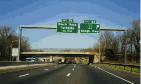
In 2001, ConnDOT completed a $50 million project to improve traffic flow through the Stamford area. This project involved widening I-95 to eight lanes and adding exit-only lanes between EXIT 8 (Atlantic Street-Elm Street) and EXIT 10 (Noroton Avenue).
Work was completed recently on a $348 million project to improve traffic flow in the Bridgeport area. The project, which was completed in 2004, involved widening I-95 to eight lanes and adding exit-only lanes between EXIT 26 (Wordin Avenue) and EXIT 29 (CT 130 / Stratford Avenue). The project featured the reconstruction of the "trumpet" interchange at EXIT 27A (CT 8-CT 25 Expressway), and the staged replacement of the 23-span Bridgeport Harbor bridge.
Work was completed during 2002 to replace an overpass and build new ramps at EXIT 41 (Marsh Hill Road) in Orange.
In 2004, ConnDOT completed a project to replace the 1,200-foot span over the West River between EXIT 44 (Kimberly Avenue) in West Haven and EXIT 45 (CT 10 / Ella T. Grasso Boulevard). The $30 million project included entrance and exit ramp improvements.
ConnDOT plans to reconstruct EXIT 46 (Sargent Drive / Long Wharf Drive), EXIT 47 (CT 34 Expressway) and EXIT 48 (I-91) in downtown New Haven. The project encompasses the elimination of left-lane exit and entrance ramps, provision of two-lane freeway-to-freeway connections, and reconstruction of 18 bridges. I-95 will be reconstructed through the area with five 12-foot-wide travel lanes (four through traffic, one acceleration / deceleration) in each direction, 12-foot-wide left and right shoulders, and a six-foot-wide concrete median barrier. Constructed of the massive project began in 2004 and is scheduled to continue through 2018.
ConnDOT is proposing a number of alternatives for replacing the Pearl Harbor Memorial Bridge ("Q Bridge") over the Quinnipiac River between EXIT 48 (I-91) and EXIT 50 (Woodward Avenue). According to ConnDOT, this section operates at severely congested levels through much of the day. The construction of a ten-lane, $700 million "signature span" (a cable-stay bridge) over the Quinnipiac River and reconstructed I-95 approaches began in 2008 with the building of foundations; the entire project continued through 2015. Unlike the old bridge, the new span has inside and outside shoulders, and has provisions for future HOV lanes.
In Waterford, ConnDOT is considering plans to reconstruct EXIT 75 (US 1) and EXIT 76 (I-395) in advance of the extension of the CT 11 Expressway. The bridge carrying US 1 over I-95 will be replaced due to damage done by trucks over the years. Because of the close proximity of EXIT 75 to the expanded EXIT 76, some or all of the ramps at EXIT 75 may be removed. A final record of decision on the rebuilt interchange and the CT 11 extension is scheduled for release in the summer of 2008.
In Groton, ConnDOT rebuilt the ramps at EXIT 86 (CT 12 and CT 184), reconstructed nearby sections of CT 12 and CT 184, and replaced the bridge carrying CT 184 over CT 12. The $7 million project was completed in 2003.
Finally, ConnDOT has developed a $1.0 billion long-range proposal to widen I-95 from New Haven to the Connecticut-Rhode Island border. Work on the first part of the project - widening the highway to six lanes from EXIT 50 (Woodward Avenue) to EXIT 54 (Cedar Street) in Branford - was completed in 2003. Construction bids for the second stage of the project, which will widen I-95 to eight lanes from the new "Q Bridge" to EXIT 50 (Woodward Avenue), have yet to be announced. A draft environmental impact statement currently is being developed for widening the existing four-lane sections between Branford and North Stonington.
|
|
|
|
|
|
|
|
|
|
|
|
|
|
|
 |
|
|
|
|
|
|
|
|
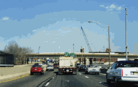
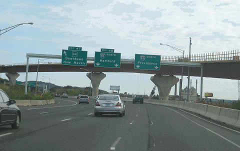
This 2010 photo shows the northbound Connecticut Turnpike (I-95) at the left exits for EXIT 47 (CT 34 Expressway) and EXIT 48 (I-91) in New Haven. ConnDOT began work in 2004 to rebuild this massive interchange and the adjacent Quinnipiac River / Pearl Harbor Memorial Bridge, also known locally as the "Q Bridge". (Photo by Steve Anderson.)
|
|
|
|
|
|
|
|
|
|
|
|
|
|
|
|
|
|
|
|
WHAT WON'T GET DONE: After intense opposition, two controversial projects planned for the Connecticut Turnpike will not be constructed. They are as follows:
In the late 1990s, the city of New Haven proposed a $500 million plan that would have placed I-95 below ground, improving access to New Haven Harbor from downtown. Although this project, which was to be part of the Long Wharf Galleria shopping mall project, received support from community and business groups, transportation professionals questioned its impact on roadway capacity and future improvements. The project was canceled in December 2000.
|
|
|
|
|
|
|
|
|
|
|
|
|
|
In October 2000, Governor John Rowland recommended that ConnDOT convert the existing shoulders on the Connecticut Turnpike through Fairfield County to through travel lanes during rush-hour periods. The I-95 breakdown lane proposal, which would have included bridge reconstruction, shoulder widening and new signing, was denied approval from the Federal Highway Administration (FHWA) two months later.
In February 2001, ConnDOT proposed closing a number of entrance ramps onto the Connecticut Turnpike through Fairfield and New Haven counties during the morning and evening rush hours. (However, the exit ramps from the turnpike would remain open.) The Connecticut State Legislature has not yet moved on this proposal, and has not specified which entrance ramps would be closed.
WHAT DOES THE FUTURE HOLD? A 2002 poll conducted by the Stamford Chamber of Commerce found that a majority of respondents favored construction of a second deck on I-95 through Fairfield and New Haven counties. Upon dismissal of the idea from the state Transportation Strategy Board, Jack Condlin, the president of the local business group, commented as follows:
Initially, I thought (decking) was a silly idea. But as I talked to more and more business people, it became clear that if we did that it would accommodate growth for the next 50 years, because if we don't we're going to become stagnant... I think this is a representation of people's frustrations with the highway system. Things are so bad on the highway that people are willing to say, "Go ahead, build a deck."
|
|
|
|
|
|
|
|
|
|
|
|
|
|
|
 |
|
|
|
|
|
|
|
|
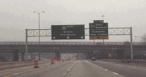
This 2001 photo shows the northbound I-95 at EXIT 83 (CT 32) in New London. This section was not part of the original Connecticut Turnpike construction. (Photo by Steve Anderson.)
|
|
|
|
|
|
|
|
|
|
|
|
|
|
 |
|
|
|
|
|
EIGHT LANES TO NEW HAVEN, SIX LANES TO PROVIDENCE: As a more permanent solution to ease congestion, I-95 should be widened from six to eight lanes between I-287 in Rye and I-91 in New Haven. In addition, I-95 should be widened from four to six lanes between New Haven and Providence.
|
|
|
|
|
|
|
|
|
|
 |
|
|
|
|
|
Upon the completion of capacity and safety improvements, the speed limit on I-95 between the New York City line and New Haven should be raised to 60 MPH.
|
|
|
|
|
|
|
|
|
|
|
|
|
|
|
|
 |
|
|
|
|
|
|
|
|
|
 |
|
|
|
 |
|
|
|
|
|
SOURCES: "Freeways Are Now Urged," The New York Times (12/13/1936); "New England Road Project Backed," The New York Times (10/29/1953); "New England South Shore Highway," Interstate Study Committee (1953); "Connecticut Turnpike To Be Opened to Traffic Today," The New York Times (1/02/1958); "Connecticut's 129-Mile, $464 Million Turnpike Is Opened to Traffic" by Richard H. Parke, The New York Times (1/03/1958); "Dates Set To Open New Route from the Bronx to Rhode Island" by Merrill Folsom, The New York Times (7/18/1958); Regional Highways: Status Report, Tri-State Transportation Commission (1962); Connecticut Highways (1959-1963), Connecticut Highway Department (1963); "Estimate of the Cost of Completing the National System of Interstate and Defense Highways in Connecticut," Federal Highway Administration and Connecticut Highway Department (1968); "Part of Bridge on I-95 Falls Into River in Greenwich, Killing Three" by Samuel G. Freedman, The New York Times (6/29/1983); The Merritt Parkway by Bruce Radde, Yale University Press (1993); "Who's Keeping I-95 Clear?" by Bill Ryan, The New York Times (5/11/1997); "The Problem: Getting There from Here" by James Lomuscio, The New York Times (10/05/1997); Divided Highways by Tom Lewis, Viking-Penguin Books (1997); "Connecticut DOT Selects Engineer for Expressway Reconstruction Project" by Ian Lisk, Public Works Online (5/14/1999); "Four Lane Expansion Considered for I-95," WTNH-TV (9/04/1999); "Interstate Route 95, New Haven Harbor Crossing, Administrative Action Final Environmental Impact Statement and Section 4(f) Statement," Federal Highway Administration and Connecticut Department of Transportation (1999); "Governor Announces Plans To Ease Traffic Woes," The Associated Press (10/02/2000); "$500 Million Long Wharf Mall Canceled" by Charles Enloe, Yale Daily News (12/13/2000); "Truck Stop and Rest Area Parking Study," Connecticut Department of Transportation (2000); "Exit Closing Plan Heads to Hartford" by Neil Vigdor, The Greenwich Time (2/19/2001); "The Road Worrier," The Norwich Bulletin (2/26/2001); "Poll Shows Support for Building I-95 Deck" by Jonathan Lucas, The Stamford Advocate (10/14/2002); "Bridgeport Overpass Destroyed, Inferno Severs Vital I-95" by John Riley, Newsday (3/27/2004); "I-95 New Haven Harbor Corridor Crossing Improvement Program," Connecticut Department of Transportation (2008); Berger, Lehman Associates; New York Metropolitan Transportation Council; Route 11 Greenway Committee; Leo Auray; Erich Bachman; Jay Hogan; Ayan R. Kayal; Dan Moraseski; Mike Natale; Scott Oglesby; Alexander Svirsky; William F. Yurasko.
I-95 and I-395 shields by Ralph Herman.
Connecticut Turnpike shield by James Lin.
Lightposts by Millerbernd Manufacturing Company.
Speed limit sign by C.C. Slater.
|
|
|
|
|
|
|
|
|
|
|
|
|
|
|
|
|
|
 |
|
|
|
|
|
CONNECTICUT TURNPIKE LINKS:
|
|
|
|
|
|
|
|
|
|
|
|
|
|
|
 |
|
|
|
|
|
|
|
|
|
 |
|
|
|
|
|
CONNECTICUT TURNPIKE VIDEOS:
|
|
|
|
|
|
|
|
|
|
|
|
 |
|
|
|
|
|
THE EXITS OF METRO NEW YORK:
|
|
|
|
|
|
|
|
|
|
|
 |
|
|
|
|
|
|
|
|
 |
|
|
|
|
|
|
|
|
|
|
|
|
Site contents © by Eastern Roads. This is not an official site run by a government agency. Recommendations provided on this site are strictly those of the author and contributors, not of any government or corporate entity.
|
|
|
|
|
|
|
|
|
|