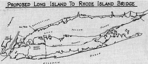
THE ORIENT POINT-WATCH HILL BRIDGE (PART 1): For decades, government officials, transportation experts and economic leaders have lobbied for the need to construct a bridge across Long Island Sound. Perhaps no proposal was as ambitious, controversial, and expensive as the one for a span from the eastern end of Long Island to the southwest tip of Rhode Island.
The earliest proposal to span the Long Island Sound came in 1938 when the Commerce Committee of the U.S. Senate discussed the possibility of a bridge beginning at Orient Point, New York, the eastern tip of Long Island's North Fork, and ending at either Groton, Connecticut or Watch Hill, Rhode Island. This idea was revived in 1957 when former New York State Department of Public Works Commissioner Charles H. Sells proposed a 24.6-mile-long bridge and causeway from Orient Point, New York to Watch Hill, Rhode Island.
The Eastern Long Island Sound Crossing was to have been an island-hopping span that would cross Plum Island, Great Gull Island and Fishers Island. Plum Island, which is home to a U.S. Government laboratory for animal disease research. Great Gull Island, the second of the islands that would have been crossed, is a bird sanctuary owned by the museum of natural history. Fishers Island, which would have the last island crossed before Rhode Island, is mostly comprised of large summer estates. All three islands, which are under the jurisdiction of New York State, are at the confluence of Long Island Sound and Block Island Sound. Citing the high cost and low traffic projections, Governor Harriman canceled the project. However, he did not rule out the Orient Point-Watch Hill Bridge when Long Island had enough commerce and traffic to warrant its construction.
By the early 1960's, Suffolk County was beginning to experience phenomenal growth. However, access to the county was only possible either by congested New York City and Nassau County highways, or by ferry to Connecticut. Officials in Suffolk County believed that unless a bridge were built to provide a direct link to New England, future growth in the county would be stifled.
From "Expressway Plans," published by the Regional Plan Association (RPA):
An entirely different kind of expressway gap is visualized by some business and civic spokesmen on Long Island. They are asking for a bridge to the east, a direct connection to New England. They argue that it would benefit Long Island by opening all of eastern Long Island to industry and by connecting two major military electronics production centers (Long Island and the Boston area). Some bridge proponents emphasize it as a way of avoiding New York City's traffic bottlenecks for Long Island trucks going south and west as well as to New England, and claim that speedier access to the mainland is necessary if Long Island's manufacturing is to be diversified. Comparison has not been made to the cost and benefit of improved expressway travel through New York City or to other bridge locations between Long Island and the mainland.
In an interview with The New York Times, H. Lee Dennison, a civil engineer by profession and Suffolk County Executive durin the 1960's, expressed the need for such the Eastern Long Island Sound Crossing:
The major point to be considered in our general economy is the fact that we are the fastest growing area in the nation, but our future may be uncertain because we jut out to sea. Our only lines of transportation and communication to New York are tenuous, congested and inadequate. Much will be heard soon about the bridge to New England.
When he left office in 1973, Dennison fought further development on the eastern end of Long Island, including proposals for the Long Island Expressway extension and cross-Sound bridges.
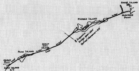
Schematic diagram of the Orient Point-Watch Hill bridge and causeway, as documented in 1961. (Maps prepared by Suffolk County Planning Department.)
THE ORIENT POINT-WATCH HILL BRIDGE (PART 2): In 1961, the Suffolk County Planning Department devised the following plans for the Orient Point-Watch Hill Bridge:
A 32-mile-long extension of the Long Island Expressway (I-495) was to be constructed from Riverhead (at EXIT 73) east to Orient Point, providing direct access to the southern anchorage of the bridge.
From Orient Point east to Plum Island, there was to be a 4,000-foot-long steel bridge, with a center span of 400 feet and a vertical clearance of 70 feet. Including the causeway, the span between Orient Point and Plum Island was to be 7,500 feet (1.42 miles) long.
On Plum Island, 15,600 feet (2.95 miles) of new highway were to be constructed.
From Plum Island east to Fishers Island, there was to be a 2,100-foot-long (measured between anchorages) suspension bridge, with a center span of 1,500 feet and a vertical clearance of 125 feet. The suspension span was to cross the main navigation channel of Long Island Sound, which has a depth of up to 200 feet below sea level. Including the causeway, the span between Plum Island and Fishers Island was to be 27,500 feet (5.21 miles) long.
On Fishers Island, 33,600 feet (6.36 miles) of new highway was to be constructed. A 1964 amendment to the bridge plan provided for a New London spur, beginning at Fishers Island and continuing north to the I-95 / I-395 interchange.
From Fishers Island east to Napatree Point (Watch Hill), Rhode Island, there was to be a 4,000-foot-long steel bridge, with a center span of 400 feet and a vertical clearance of 70 feet. Including the causeway, the span between Fishers Island and Rhode Island was to be 11,700 feet (2.22 miles) long.
Finally, the I-495 extension was to be constructed from the northern anchorage of the bridge north to Interstate 95 (Rhode Island), between EXIT 1 and EXIT 2.
All causeway sections were to be 100 feet long, with minimum vertical clearances of 30 feet.
After initial cooperation with New York officials, officials from Rhode Island backed out of the Orient Point-Watch Hill Bridge proposal in 1966, citing that the crossing was "not economically feasible."
In 1971, the New York State Department of Transportation (NYSDOT) commissioned the consulting firm Creighton, Hamburg Incorporated for a study for proposed alternative bridge locations. The proposed Orient Point-Watch Hill Bridge was estimated to cost $634.8 million, the costliest of the eight locations, and was to have been supported by base tolls of $3.75 each way. At 6,800 vehicles per day, the Orient Point-Watch Hill Bridge would have had the lowest AADT (annual average daily traffic) counts. It also would have had the most devastating impact on the environment, taking nearly 150 acres of wetlands.
Three decades later, the NYSDOT estimated that a bridge across Long Island Sound would cost $20 billion to $25 billion. An independent estimate (conducted for nycroads.com) found that if built today, the Orient Point-Watch Hill Bridge would cost $5.6 billion to construct, and an additional $4.5 billion in interest costs. However, such a bridge would only bring $3.1 billion in toll revenue over 30 years.
OTHER EASTERN SOUND PROPOSALS: There were two other crossings proposed between the North Fork of Long Island and southeastern Connecticut as follows:
RIVERHEAD-GUILFORD BRIDGE: This 19.2-mile bridge would have included a short extension of the Long Island Expressway (I-495) from its Riverhead terminus. On the Connecticut end of the span, I-495 would have connected with the Connecticut Turnpike (I-95) near EXIT 59 in Guilford. In 1971, the bridge was estimated to cost $494.5 million, and the approach expressways were to cost an additional $15 million.
EAST MARION-OLD SAYBROOK BRIDGE: This 9.8-mile bridge would have included a 25-mile extension of the Long Island Expressway (I-495) between Riverhead and East Marion. On the Connecticut end of the bridge, I-495 would have connected with the Connecticut Turnpike (I-95) at EXIT 69 (CT 9 Expressway) in Old Saybrook. In 1971, the bridge was estimated to cost $335.8 million, and the approach expressways were to cost an additional $55 million.
The Orient Point-Watch Hill Bridge (Eastern Long Island Sound Crossing) would have carried I-495 from eastern Long Island to Rhode Island via a series of islands at the confluence of Long Island Sound and Block Island Sound. An I-395 spur was planned between Fishers Island and the New London, Connecticut area. In all, about 40 percent of the Eastern Long Island Sound Crossing was to be over islands. (Photo of the I-664 Monitor-Merrimac Memorial Bridge-Tunnel across Hampton Roads by Scott Kozel.)
SOURCES: "Across the Sound" by Byron Porterfield, The New York Times (7/09/1961); "Proposed Long Island to Rhode Island Bridge," Suffolk County Planning Department (1961); "Expressway Plans," Regional Plan Association News (May 1964); "Rhode Island Route Studied" by Douglas Dales, The New York Times (8/19/1964); "Long Island Sound Bridge Study Commission: Report to the General Assembly," Rhode Island Legislature (1966); Transportation 1985: A Regional Plan, Tri-State Transportation Commission (1966); A Comprehensive Transportation Study for Proposed Bridge Crossings, Creighton, Hamburg, Incorporated (1971); Long Island Sound Crossing, Metropolitan Transportation Authority and New York State Department of Transportation (1972); Long Island Sound Bridge Study, New York State Department of Transportation (1979); "The Great Escape" by Tom Morris, Newsday (10/31/1999); Daniel T. Dey; Ralph Herman; Nick Klissas; Scott Kozel; Scott Oglesby; Jim Wade.