 |
|
|
|
|
|
|
|
|
|
|
|
|
|
|
|
|
|
|
|
|
|
|
|
|
|
|
|
|
|
|
|
|
|
|
|
|
|
|
|
|
|
|
|
|
|
|
|
|
|
|
|
|
|
|
|
|
 |
|
|
|
 |
|
 |
|
|
|
|
|
|
|
|
|
|
|
|
 |
|
|
|
|
|
|
|
|
|
|
|
 |
|
|
|
|
|
|
|
|
|
|
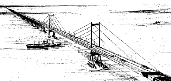
This 1966 drawing by engineering firm Sverdrup & Parcel depicted the main cable-stay span of the proposed bridge between Suffolk County and Connecticut. (Drawing from the Suffolk County Planning Department archives.)
|
|
|
|
|
|
|
|
|
 |
|
|
|
|
|
|
|
|
"A mid-Suffolk bridge is as inevitable as death and taxes." - New York State Senator John L. Caemmerer (R-East Williston, NY), in a 1978 Newsday interview
"Is it a reasonable notion to believe that a tunnel or bridge should cross the Long Island Sound to Connecticut or Westchester? The answer is, 'Yes.' But, I have a feeling that building the 'Chunnel' between England and France... will be easier than going from Long Island to Connecticut. I don't think price is the impasse. Even if someone was going to give us a tunnel or a bridge, I don't think there is enough political will to get it done." - Mitch Pally, executive director of the Long Island Association, in a 2001 Newsday interview
THE NEED FOR A MID-SUFFOLK TO CONNECTICUT BRIDGE: In 1957, Charles H. Sells, a former New York State Public Works Commissioner, proposed two spans at the western and eastern ends of Long Island Sound. Toward the western end of the Sound, one bridge was planned between Oyster Bay, Nassau County and Rye, Westchester County. At the eastern end of the Sound, a bridge and causeway was proposed between Orient Point, Suffolk County and Watch Hill, Rhode Island, via Fishers Island. While Sells thought these spans to be feasible from an engineering standpoint, he did not recommend their construction until Long Island had more commerce and traffic. No mention was made of a span between central Suffolk County and southern Connecticut, where Long Island Sound is at its widest point between the two shorelines.
The first mention of a bridge between Suffolk County and Connecticut came in 1967, when New York Governor Nelson Rockefeller signed the $2.5 billion Omnibus Transportation Act. This act, which also authorized the construction of the Oyster Bay-Rye Bridge and the creation of the Metropolitan Transportation Authority (MTA), proposed a 14.6-mile bridge between Port Jefferson and Bridgeport. Currently, an automobile ferry operates at this location.
In 1968, the New York State Department of Transportation (NYSDOT) commissioned Wilbur Smith and Associates, a New Haven-based consulting firm, for a study on the proposed Port Jefferson-Bridgeport Bridge. The 14.6-mile span, which would include a main suspension span of 1,500 feet near the Long Island shoreline and a 600-foot-long secondary span near the Connecticut shoreline, would cost $368.3 million. At its southern terminus, the bridge would be connected to a new north-south expressway, the A.O. Smith Turnpike (Suffolk CR 110), which would run from the bridge's southern terminus in Port Jefferson to the limited-access Nicolls Road (Suffolk CR 97) in Centereach. At its northern terminus, the bridge would be connected to the CT 8-CT 25 expressway near the intersection with the Connecticut Turnpike (I-95). The approaches would cost an additional $40 million to construct.
The Wilbur Smith report said the following of the bridge's impact on Suffolk County:
Industrial development in Suffolk County will be enhanced by the proposed crossing. Once it is constructed, the multiplier effect will spread its influence throughout all areas of the community. Each additional industrial worker serves to create many additional jobs in satellite service industries, and the economic advantages are multiplied many times throughout all facets of the community.
The impact of the proposed bridge would not be limited to Long Island. Another study of the Port Jefferson-Bridgeport Bridge conducted in 1968 by the consulting firm Howard, Needles, Tammen and Bergendoff described the potential benefits for Connecticut:
The bridge will open up untold market potential by improving the opportunity of Connecticut residents in business and tourist travel throughout the area. It will enhance New Haven's position as a regional distribution center between Long Island and the rest of New England because of easier travel connections.
THE BATTLE OF THE BRIDGE (PART 1): During the next several years, much of the attention was focused on the proposed Oyster Bay-Rye Bridge. Because the existing East River bridges between the Bronx and Queens were running at or above capacity, the proposed Oyster Bay-Rye Bridge was perceived as a solution to the traffic bottlenecks through New York City. Moreover, the Oyster Bay-Rye Bridge would connect well-established residential, commercial and industrial areas on both sides of the Sound. In comparison, a Suffolk-to-Connecticut bridge would generate only about one-third of the potential traffic of the proposed Nassau-to-Westchester span. Finally, the Oyster Bay-Rye Bridge, which at a length of 6.1 miles would be less than half the distance of a central Sound crossing, would cost only $167.9 million. Construction of Oyster Bay-Rye Bridge approach expressways would add another $70 million, but unlike for the Port Jefferson-to Bridgeport span, the state already had the expressway rights-of-way set aside.
|
|
|
|
|
|
|
|
|
|
|
|
|
|
|
|
|
|
|
|
|
|
In 1971, the NYSDOT commissioned a second consulting firm, Creighton, Hamburg, Incorporated, for a study of alternative bridge crossings. The study ruled out the five alternative locations between Suffolk County, Connecticut and Rhode Island. Instead, it favored construction of a Nassau-to-Westchester span:
The five eastern bridges have much lower traffic volume and much higher construction costs than the three western bridges. Substantial direct subsidies would most likely be required before bonds could be sold. Therefore, these bridges are not recommended for further consideration at this time. However, for the three western bridges, traffic volumes are sufficiently great so that they would, at optimum (maximum revenue generating) tolls, pay all debt service requirements arising out of estimated construction costs over a 40-year term.
|
|
|
|
|
|
|
|
|
|
|
|
|
|
|
|
|
|
|
|
|
When the Oyster Bay-Rye Bridge proposal was defeated in 1973, the idea for a bridge across Long Island Sound appeared dead.
THE SHOREHAM-NEW HAVEN BRIDGE: By the late 1970's, discussion of a cross-Sound bridge resurfaced. This time, the focus was on a crossing between Shoreham, a small Suffolk community 12 miles east of Port Jefferson, and the New Haven area. The Long Island-based Newsday, in its 1978 series "Long Island at the Crossroads," advanced this proposal in conjunction with a deep-water seaport in the Shoreham-Wading River area and an airport for international freight at the site of the Calverton Naval Weapons Industrial Reserve Plant. Newsday advanced the following reasons for construction of the Shoreham-New Haven Bridge:
The Shoreham-New Haven Bridge would foster the ultimate incorporation of Long Island into the Northeast Corridor. In this scenario for the next century, a bridge, together with such major transportation improvements such as the Shoreham-Wading River deepwater seaport and the Calverton air cargo center, would form a permanent economic foundation on the Island.
The bridge would open a new area of trade between Long Island and New England. It would provide a viable bypass of the current New York City bottleneck and, as a consequence, a new freedom for industry on the Island to expand existing plants and employment, as well as attract new investment. According to Wilbur Smith and Associates, more than 40,000 new jobs would be created in Suffolk County alone once the bridge is completed.
The Shoreham-New Haven Bridge would free the rail and trucking industries from their current Long Island albatross. Because the Island is a dead-end route, the operation of empty trucks on return trips is costly.
The Shoreham-New Haven Bridge would create easier access for private motorists who want to travel between the Island and New England without going through New York City. This would improve prospects for tourism on both sides of the Sound.
In addition to fostering economic growth on Long Island, the Shoreham-New Haven Bridge would encourage such growth in Connecticut by opening new markets for products, by making it cheaper to transport such products, and by increasing job opportunities. According to a study conducted by the state of Connecticut, the bridge would create more than 15,000 jobs in the Bridgeport-New Haven area once it is completed.
There would be an immediate increase in jobs both in bridge construction and in associated service industries. According to the NYSDOT and the MTA, construction of the bridge would result in an average of 2,100 construction jobs over three years, with a peak of 3,000 construction jobs. The number of new jobs generated in bridge-related service industries would be even higher.
Of the eight bridge alternatives selected in the 1971 Creighton, Hamburg study, the Shoreham-New Haven Bridge alternative was the only one that would not generate significant noise or air pollution. It would also cause the least disruption to communities among the eight alternatives. The bridge would require the taking of 25.9 acres of wetlands, among the lowest of the eight locations.
DESCRIPTON OF THE BRIDGE: Like the Oyster Bay-Rye Bridge, the Shoreham-New Haven Bridge would consist of a series of spans with the main opening presently proposed to be centered one and one-half to two miles north of the Long Island shore, where the majority of commercial vessels now travel. The main span would be 1,200 feet center-to-center between the towers, and would provide a minimum of 135 feet vertical clearance above mean high water. These clearances are not less than the minimums now provided at the existing crossings of the East River, which is a continuation of the Long Island Sound waterway.
Lesser clearances would be provided by the flanking and approach spans. The minimum spans would be 100 feet long, with vertical clearances of 25 feet. To accommodate recreational boating and shallow draft commercial vessels, a section with greater clearances, including a 200-foot center span 55 feet above mean high water, would be located near the Connecticut shore. All clearances and the locations of spans would be subject to approval by the U.S. Coast Guard.
|
|
|
|
|
|
|
|
|
 |
|
|
|
|
|
|
|
|
|
|
|
|
|
|
|
|
|
|
ESTIMATED TRAFFIC AND PROJECT COSTS: According to the 1979 Long Island Sound Bridge Study conducted by the NYSDOT, it was estimated that the Shoreham-New Haven Bridge would carry an average of 15,500 vehicles per day, based on a 1990 toll of $6.00 each way. The proposed four-lane, 19.3-mile span between Suffolk County and Connecticut was estimated in 1971 to cost $565 million. By 1979, spiraling inflation had pushed this cost estimate to $1.4 billion.
The 1979 Long Island Sound Bridge Study also warned about a Suffolk-to-Connecticut crossing as follows:
|
|
|
|
|
|
|
|
|
|
|
|
BRIDGE CONNECTING ROADS: On the Suffolk County side, the bridge approaches would connect directly with William Floyd Parkway (Suffolk CR 46), which would be extended from its present northern terminus at NY 25A in Shoreham. This artery, which has a design capacity of 57,000 vehicles per day, currently carries about 25,000 vehicles per day. The William Floyd Parkway would be taken over by the NYSDOT, which would convert the four-lane artery into an expressway between NY 25A and the Long Island Expressway (I-495) in Yaphank, and possibly as far south as Sunrise Highway (NY 27) in Shirley. (Upon completion of the bridge, the William Floyd Parkway would become part of I-91.)
|
|
|
|
|
|
|
 |
|
|
|
|
|
|
|
|
|
|
|
In Connecticut, the bridge approach would lead into Interstate 91. Two approach alternatives in the New Haven area were chosen as follows:
The first approach alternative would make landfall in East Haven, traveling up the east shore of New Haven Harbor to the Connecticut Turnpike (I-95) between EXIT 50 and EXIT 51. I-91 and I-95 would be multiplexed for 1.5 miles between the end of the northern approach in East Haven and EXIT 48 in New Haven.
The second approach alternative, which would enter Connecticut at West Haven, would require a slightly longer over-water crossing. It would reach the Connecticut Turnpike between EXIT 43 and EXIT 44. From the end of the northern approach in West Haven, I-91 and I-95 would be multiplexed for one mile to EXIT 48, where I-91 and I-95 would then split.
|
|
|
|
|
|
|
 |
|
 |
|
|
|
|
|
|
|
|
|
|
Of the two northern approach alternatives, the East Haven alternative was preferred because it would cause less community disruption. Radial routes such as I-95 (New England Thruway, Connecticut Turnpike) and I-495 (Long Island Expressway) would be relieved of some traffic by the Shoreham-New Haven Bridge, since many vehicles now crossing via the East River bridges from Long Island to would be diverted to the new bridge.
THE BATTLE OF THE BRIDGE (PART 2): In 1978 and 1979, the NYSDOT and ConnDOT held town meetings on both sides of Long Island Sound. Opinion was evenly divided in the Suffolk County hearings, but overwhelmingly against the bridge in the Connecticut hearings. The meetings were contentious, as the following statements bear out.
Most Long Island businesses and local politicians were allied with the pro-bridge forces. From the Long Island Association, Long Island's largest regional business group:
The overriding consideration here is a simple one and really the only one. This crossing will be built because the economic and social pressures make it a natural evolution. This is not solely a Long Island issue. The entire Northeast will be impacted by it, or by its absence. Long Island knows it, Rhode Island knows it, and, except for its Governor and a few other officials currently holding office, Connecticut knows it.
From a Suffolk County Legislator:
A bridge linking Long Island to mainland New England at Connecticut is desperately needed. For Long Island to maintain an isolationist approach to the Northeast would spell economic disaster: higher taxes, consumer prices and unemployment.
Connecticut Governor Ella Grasso, New York Governor Hugh Carey and U.S. Senator Abraham Ribicoff led the opposing camp. Ribicoff was a veteran of the battle against the Oyster Bay-Rye Bridge in the early 1970's.
From Governor Ella Grasso:
I am opposed to the Long Island Sound Bridge proposal. A number of studies in the past have indicated no real economic benefit to the state of Connecticut.
Nathaniel Griffin, board chairman and chief executive officer of Suffolk County Federal Savings and Loan Association, was one business leader who opposed the bridge:
I'm not too enthusiastic about the idea. A bridge might be used by people who have no idea at all of stopping on Long Island. The question is whether it will destroy the quality of life without providing for a higher economic status.
No further progress on the Shoreham-New Haven Bridge was made after the hearings ended in 1979. However, it did appear on the 2010 Master Plan developed by the Nassau-Suffolk Regional Planning Board in 1990. Through much of the 1990's, attention was shifted toward developing a high-speed ferry route between Shoreham and the New Haven area. Like the bridge plans, the high-speed ferry plans never made it past the planning stages.
RESURRECTING THE CROSS-SOUND BRIDGE? During the late 1990s, in the early stages of the "LITP 2000" study, the NYSDOT solicited a number of ideas from the public, including resurrecting the Oyster Bay-Rye and Shoreham-New Haven crossings. (A new location, between Sunken Meadow State Park in Kings Park and Sherwood Island State Park in Westport, Connecticut, was added to the study.)
In the next stage of the process, the Nassau-to-Westchester bridge proposal was dropped, leaving only the Suffolk-to-Connecticut proposals to be studied. According to computer models recently developed by the NYSDOT, between 3,000 and 5,000 vehicles per hour would utilize the Shoreham-New Haven Bridge during peak morning and afternoon periods.
The NYSDOT backed away from a Long Island Sound bridge alternative in the belief that it would do nothing to relieve road congestion. The high costs of environmental studies and construction, along with strident community opposition, also weighed heavily in the NYSDOT decision.
Nevertheless, support for a cross-Sound bridge remains strong. In a 2000 poll conducted by Newsday and News 12-Long Island, 63 percent of Long Island residents favored a bridge between Suffolk County and Connecticut. Moreover, the Long Island Association continues to be a strong supporter of a cross-Sound bridge.
In 2016, Governor Andrew Cuomo proposed a new crossing between Shoreham and the New Haven area, with two northern alternative approaches on I-95 at EXIT 50 (US 1) in New Haven and at EXIT 53 (Short Beach Connector) in Branford. Among the three alternatives, the Shoreham-New Haven Bridge was found to provide the least traffic relief. Cost estimates for this alternative ranged from $15.5 billion for the bridge-only alternative to $30.1 billion for a twin-tube, six-lane tunnel-only alternative. As was the case nearly half-century earlier, activists on both sides of the Sound opposed all of the new alternatives. In 2018, the state once again ended discussion of any proposal, with acting NYSDOT Commissioner Paul Karas stating that the project would not be moving forward "at this time."
|
|
|
|
|
|
|
|
|
 |
|
|
|
|
 |
|
|
|
|
|
A DIRECT LINK TO NEW ENGLAND: The terrorist attacks of September 11, 2001 left Long Island with no escape routes, since all access points to New York City and the outside world were closed for two days. To supplement the Oyster Bay-Rye crossing, a new bridge, tunnel or bridge-tunnel combination should be constructed to connect Suffolk County with southern Connecticut. Ideally, the extension of I-91 to Long Island would be combined with a new international air cargo facility at Calverton Naval Weapons Industrial Reserve (Grumman) Plant.
|
|
|
|
|
|
|
|
|
|
|
|
|
|
While the Oyster Bay-Rye Crossing would serve to bolster development and ease congestion in the western Long Island Sound region, the Shoreham-New Haven Bridge would serve a different purpose. For the first time, there would be a direct all-weather link between Long Island and other major New England markets. Business and tourism opportunities would be enhanced on both sides of the Sound, particularly on eastern Long Island and in southern Connecticut. Firms conducting business between the two regions would benefit through the reductions in travel time, fuel costs and other associated operating expenses.
The proposed bridge would include a 1,500-foot-long main cable-stay span to cross the main shipping channel of Long Island Sound, just north of the Long Island shoreline. The main span would have a clearance of no less than 135 feet. Bumpers would be placed around the bridge supports to protect them against collision and ice flows. A secondary 400-foot span with a clearance of 60 feet would be placed just south of the Connecticut shoreline. The bridge would have capacity for four travel lanes (two lanes in each direction), with an emergency shoulder along the entire length of the bridge.
In Suffolk County, the William Floyd Parkway (Suffolk CR 46) would be widened to six lanes from the southern bridge approach in Shoreham to Montauk Highway (NY 27A-Suffolk CR 80) in Shirley, as part of its conversion to Interstate 91. Service roads would be built as necessary between NY 27 and Middle Country Road (NY 25) in Ridge.
In Connecticut, the northern approach would utilize the East Haven alternative, where there would be less community disruption. It would have an interchange with the Connecticut Turnpike (I-95) between EXIT 50 and EXIT 51, bypassing downtown New Haven up the east bank of the Quinnipiac River before joining the existing I-91 near EXIT 8. The existing portion of I-91 through downtown New Haven would then be designated as I-491. As a result, southbound traffic using I-91 in Connecticut would travel onto the new I-91 to Long Island (as well as to the northbound I-95), while New York City-bound traffic would travel on I-491 to the southbound I-95.
To reduce community impact, no exits would be constructed north of NY 25A, or south of I-95. To minimize of air pollution, no toll plaza would be constructed. Instead, gantries capable of reading EZ-Pass transponders at high speeds would be installed. Retaining walls, earthen berms and trees would be used to insulate noise from the northern and southern approaches from the communities in which they will pass. Finally, no changes in zoning would take place in the affected areas.
While the benefits of the Shoreham-New Haven Bridge are apparent, construction of the bridge would await completion of the Oyster Bay-Rye crossing (probably sometime after 2035), when both traffic counts and toll revenues would justify its construction. Such a crossing would require the creation of a bi-state agency with Connecticut, which would have to be approved by Congress. Moreover, any attempt to finance both the Oyster Bay-Rye and Shoreham-New Haven crossings at the same time would kill any chance for either crossing to be built.
|
|
|
|
|
|
|
|
|
 |
|
|
|
|
|
|
|
|
|
 |
|
|
|
 |
|
|
|
|
|
SOURCES: Transportation 1985: A Regional Plan, Tri-State Transportation Commission (1966); "Proposed Suffolk County to Connecticut Bridge Crossing," Wilbur Smith and Associates (1968); A Comprehensive Transportation Study for Proposed Bridge Crossings, Creighton, Hamburg, Incorporated (1971); Long Island Sound Crossing, Metropolitan Transportation Authority and New York State Department of Transportation (1972); "A Bridge Link to Connecticut Could Spur Long Island's Economic Growth," Newsday (3/22/1978); "Connecticut Study Says Bridge Would Increase Jobs," Newsday (3/22/1978); "Air Cargo, Port Facilities Tied to Bridge," Newsday (3/22/1978); Long Island Sound Bridge Study, New York State Department of Transportation (1979); "The Great Escape" by Tom Morris, Newsday (10/31/1999); "A Bridge to Connecticut? 63% Say Yes" by Thomas Frank, Newsday (2/28/2000); "To Get There from Here, Wait 20 Years" by Vivian S. Toy, The New York Times (6/25/2000); "A Tunnel for the Sound? Someone Digs This Idea" by John Valenti, Newsday (1/21/2001); "Cuomo Administration Drops Idea for Bridge-Tunnel Crossing LI Sound" by Yancey Roy, Newsday (6/29/2018); Daniel T. Dey; Ralph Herman; Nick Klissas; Scott Kozel; Scott Oglesby; Jim Wade.
I-91, I-95, and Suffolk CR 46 shields by Ralph Herman.
|
|
|
|
|
|
|
|
|
|
|
|
|
|
|
|
|
|
|
|
|
|
|
|
|
|
|
|
|
 |
|
|
|
|
|
|
|
|
 |
|
|
|
|
|
|
|
|
|
|
|
|
Site contents © by Eastern Roads. This is not an official site run by a government agency. Recommendations provided on this site are strictly those of the author and contributors, not of any government or corporate entity.
|
|
|
|
|
|
|
|
|
|