 |
|
|
|
|
|
|
|
|
|
|
|
|
|
|
|
|
|
|
|
|
|
|
|
|
|
|
|
|
|
|
|
|
|
|
|
|
|
|
|
|
|
|
|
|
|
|
 |
|
 |
|
|
|
|
|
|
|
|
|
|
|
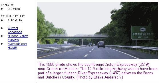
PART OF A LARGER PLAN: In the mid-1960's, the 47-mile "Hudson River Expressway" (I-487) was proposed between New York City and Beacon, Duchess County. Only one section of the expressway - the Croton Expressway - was constructed. The Croton Expressway, which was to have been part of a much larger "HRE," carries US 9 for 9.2 miles between Ossining and Peekskill in northern Westchester County. Opened in 1967, the expressway was constructed instead of the Briarcliff-Peekskill Parkway extension, which was to have been built through Teatown Lake Reservation, Croton Dam Plaza and Blue Mountain Reservation.
According to the New York State Department of Transportation (NYSDOT), the Croton Expressway handles approximately 40,000 vehicles per day (AADT).
|
|
|
|
|
|
|
|
|
 |
|
|
|
|
 |
|
|
|
|
|
|
|
|
THE PROPOSED HUDSON RIVER PARKWAY (1927-1937): Before the Hudson River Expressway was planned, another parkway was proposed along the Hudson River shoreline. The Hudson River Parkway was initially proposed by business groups in Yonkers who sought a north-south bypass along the eastern shore of the Hudson River. This route was to continue south into the Bronx, where it was to connect with the proposed Henry Hudson Parkway. In 1927, the Westchester County Parks Commission adopted the Hudson River Parkway proposal, but had not committed itself to constructing the road.
From the 1928 Westchester County Parks Commission Report:
While policy has been to develop through traffic routes principally through vacant and undeveloped lands, a parkway along the Hudson River shore from Yonkers to Peekskill and the Bear Mountain Bridge presents great possibilities because of the scenic beauties of its location and great practical benefit to the whole westerly side of the county.
The investigation of the Hudson River Parkway route involves not only engineering matters, but also intricate negotiations with municipal, railroad and other public service authorities. Options or easements covering right-of-way lands will be necessary in order to formulate reasonably reliable cost estimates, which naturally will be higher than that for routes through undeveloped territory. The Hudson River Parkway is also subject to limitations in the creation of enhanced real estate valuations because it has only one frontage, whereas inland routes enhance valuations along two frontages and their flanking zones covering considerable areas. There also arises a question of policy as to whether the Commission should not receive some aid from the local municipalities and from state authorities in undertaking a project of this character.
By 1930, the commission, still uncommitted to the project, estimated that the cost of the 30-mile Hudson River Parkway from Yonkers to Peekskill would be $55 million. Although the high price tag was attributed in part to the construction of grade separations through developed areas, the cost was prohibited as far as the commission was concerned. As late as 1937, the commission attempted to obtain state and federal funds for its construction, but to no avail.
EXPRESSWAY PLANS (1936-1961): As early as 1936, the Regional Plan Association (RPA) proposed an expressway from New York City north to Albany along the eastern shore of the Hudson River. Unlike the parkways of the era, the expressway was to be open to all vehicles. Plans to construct the expressway, which was to parallel the existing US 9, would be delayed by World War II.
During the late 1940's, the New York State Thruway Authority (NYSTA) routed the proposed New York State Thruway along the east side of the Hudson River from the Newburgh-Beacon Bridge to the Bronx. The route was to be part of the state's 1,780 network of "interstate and interregional highways." By 1951, the NYSTA changed the route such that the thruway crossed the Hudson River between Rockland and Westchester counties.
In 1952, the New York State Department of Public Works (NYSDPW) announced plans to construct bypasses of existing US 9 to alleviate congestion around downtown areas such as Yonkers, Tarrytown and Peekskill. Four years later, the NYSDPW announced a more ambitious plan to construct a continuous expressway along the eastern shore of the Hudson River. The proposed highway, which was to be part of the Interstate highway system, was to serve as a relief route for US 9, the Saw Mill River Parkway and Taconic State Parkway.
|
|
|
|
|
|
|
|
|
|
|
|
|
|
The 30-mile-long, four-to-six lane section, which became known as the "western alignment" of I-87, was to begin at the intersection of the New York State Thruway and the Cross Westchester Expressway (I-287) in Elmsford, continue north on a route east of Peekskill, and end north in Beacon at I-84 near the eastern approach of the then-proposed Newburgh-Beacon Bridge. From there, I-87 would have been multiplexed with I-84 before rejoining the Thruway at Newburgh. The $60 million section was conditionally approved by the Federal Bureau of Public Roads in 1957.
|
|
|
|
|
|
|
|
|
|
|
|
|
|
|
|
|
|
The route recommended by the NYSDPW was also studied earlier in 1956 by the Westchester County Planning Department. The county advocated a 15.7-mile "north-south thoroughfare" along the US 9 corridor from Briarcliff Manor to Peekskill. On the basis of studies conducted by the county, the corridor was designated as a high priority corridor.
From the recommendation report:
The purpose of this route is to provide an express route along the Hudson River for mixed through traffic destined to or originating in northern municipalities between the river and the Taconic State Parkway. The route may ultimately serve as a link in an expressway connection between the Hudson Division of the Thruway (at or near Elmsford) and the Berkshire Division of the Thruway, thus in effect becoming an east-of-the-Hudson Thruway.
In the Briarcliff Manor-Ossining area, the easterly alternative would follow the present right-of-way of NY 9A (Briarcliff-Peekskill Parkway). The westerly alternative would parallel Sleepy Hollow Road, and would join NY 9A in the vicinity of Central Drive. From this point, the route would proceed northward along the existing right-of-way of NY 9A. The route would then run northwesterly on a new alignment somewhat north of the Briarcliff-Peekskill Parkway spur, and cross the Croton River approximately 0.3 mile north of the present bridge.
Between Cortlandt and Peekskill, the proposed route would proceed northwesterly to intersect existing US 9 north of Harmon Station. From this point through the city of Peekskill to the Putnam County line, it is proposed to improve existing US 9, with some deviations from the existing right-of-way.
The 1956 alignment was to cut through the 8,000-acre estate held by the Rockefeller family in Potantico Hills. When Nelson Rockefeller became governor of New York in 1959, this became a factor that would influence the path of the proposed expressway. In February 1961, the NYSDPW abandoned plans for this alignment and moved I-87 five miles east to what is now the current alignment of I-684. (The I-87 designation was reassigned to the New York State Thruway in Westchester and Rockland counties in wake of the Highway Act of 1968, when the section between I-287 and I-84 became eligible for Interstate funding.)
According to the official NYSDPW report, the "western alignment" was not chosen for the following reasons:
East of the Hudson, north-south through traffic is served by such highways as Routes 9 and 9A, insofar as passenger vehicles are concerned, the Taconic State Parkway. Also of concern is the fact that a new expressway along the Hudson would lead an additional four to six lanes of southbound traffic into the six-lane Thruway, which already connects with other major routes and even now frequently carries traffic volumes larger than design capacity in the Westchester-New York City area.
The new Interstate route along the Hudson also would require construction of additional - and more complex - interchange facilities. These would wipe out a substantial percentage of existing development in a local region that has already experience considerable dislocation from the convergence of the Thruway, Cross Westchester Expressway and Saw Mill River Parkway. Concurrently, such a location would increase traffic congestion and cause problems for interchanging traffic in and around the Tarrytown-Elmsford area.
|
|
|
|
|
|
|
|
|
|
|
|
|
|
 |
|
|
|
|
|
This 1960 Rand McNally map shows the original alignment of I-87 along the US 9 corridor in Westchester County. Note that I-487 was originally assigned to the Cross Westchester Expressway. The original alignment of I-87 was moved east to the current I-684 corridor in 1961. In 1965, the proposed Hudson River Expressway (I-487) was routed along the east bank of the Hudson River. (Map © 1960 by Rand McNally; scanned by Dave Schul.)
|
|
|
|
|
|
|
|
|
|
|
|
|
|
|
|
 |
|
|
|
|
|
EXPRESSWAY PLANS (1965): Over the years, the problem with congestion along US 9 and the Hudson River corridor would only become worse. On April 28, 1965, the mayors of four municipalities - Tarrytown, North Tarrytown (now Sleepy Hollow), Ossining and Briarcliff Manor - together formally proposed bypasses of US 9 and petitioned Governor Rockefeller for action. What came later stunned these municipalities.
|
|
|
|
|
|
|
|
|
|
|
|
|
|
In May 1965, Governor Rockefeller announced plans for the Hudson River Expressway, a 47-mile, six-lane Interstate highway between the Riverdale section of the Bronx and Beacon, Dutchess County. The NYSDPW described the Hudson River Expressway proposal as follows:
Beginning at a point on Interstate route 503 (I-84) in the vicinity of Beacon, to be determined by the superintendent of public works, thence in a generally southerly direction to the vicinity of Ossining and then continuing southerly, west of US Route 9, along or near the Hudson River to the north city line of New York, thence generally southerly and easterly to a connection with Interstate route connection 512 (I-87 / Major Deegan Expressway) in the city of New York, to be determined by the superintendent of public works.
Unlike the earlier proposal, the proposed expressway was to be built directly along the east shore of the Hudson River, minimizing dislocation. For a distance of four and one-half miles, the expressway was to be constructed on approximately 9.5 million cubic yards of fill, bound by a rock wall, along the portion of the riverbank. At its widest point, the landfill was to extend 1,300 feet into the Hudson River. Beaches and parks were also to be constructed on the landfill. Inland, the expressway was to be constructed through the Sing Sing Correctional Facility in Ossining. (The Sing Sing "Death House," where the state's electric chair was used until 1963, was to be torn down to make way for the expressway.)
Official silence was placed on the Hudson River Expressway project through the late spring of 1965. Although the HRE was an Interstate project financed with 90 percent Federal funds - it was to cost as much as $10 million a mile, according to some estimates - there were no public hearings (as required by law) before the bill was passed by the New York state legislature. While local officials were not informed, they were led to believe that their original petition to alleviate congestion on US 9 and NY 9A was being acted upon favorably.
In place of the usual specific title, which describes the areas to be affected, the bill presented to the Legislature simply read, "To Amend the Highway Law, in Relation to State Expressway on the State Highway System." In addition, customary route identification numbers usually found on official highway maps were not used for the proposed expressway. However, since it was to close the loop between the Major Deegan Expressway and the "eastern alignment" of I-87, other sources show the HRE receiving the unused I-487 designation.
The Hudson River Expressway was part of a larger plan to upgrade the US 9 corridor between New York City and Albany. In its report Transportation 1985: A Regional Plan, the Tri-State Transportation Commission proposed the continuation of the expressway north along the US 9 corridor from I-84 in Beacon to I-90 near Albany. The east-of-the-Hudson expressway, which was to utilize an already completed section in Poughkeepsie, was to relieve congestion along the two-lane US 9 and provide more local service than the west-of-the-Hudson New York State Thruway.
During the summer of 1965, the NYSDPW held a closed-door meeting with the mayors of all the municipalities along the proposed route of the HRE. However, it would not take along before the details of the route were leaked to the public, allowing opposition to form. A group of residents formed The Citizens Committee for the Hudson Valley (CCHV) "to fight these proposed highways and any other future sacrificing encroachments of the Hudson's remaining natural beauty, by publicity, by organization of community protests, and, where feasible, by legal action." Opposition came from the Federal level as well. In a letter, Interior Secretary Stewart Udall asked the Commerce Department to withhold funds for the 47-mile HRE pending congressional resolution of the "Hudson Highlands National Scenic Riverway" plan:
It is apparent from the information furnished by Congressman Ottinger that a high-speed expressway serving commercial and industrial traffic, as well as automobiles, is contemplated. Such an expressway in the highly scenic and significantly historic corridor along the Hudson River would seriously impair the values that we are all trying to preserve.
Countering the opposition, local officials supported the construction of the Hudson River Expressway. S.J. Schulman, the planning commissioner for Westchester County, contended that the expressway would "result in cleaning up the shoreline of the Hudson" and "tie in with the new Federal highway program for beautiful highways, and the state plan to clean up the waterways." Charles E. Pound, county commissioner for parks, recreation and conservation, saw the expressway as an opportunity to "clean up the riverfront and provide a magnificent scenic drive."
|
|
|
|
|
|
|
|
|
|
|
|
BACK TO THE DRAWING BOARD (1968): By August 1965, mounting opposition to the 47-mile-long HRE proposal caused Governor Rockefeller to cancel plans to build the southern section between the Bronx and Tarrytown. In 1967, the section from Peekskill north to Beacon was canceled. With the section between Ossining and Peekskill being constructed as US 9, the only section that remained on the planning board was a 10.4-mile section from Tarrytown to Ossining.
|
|
|
|
|
|
|
 |
|
|
|
|
|
|
|
|
|
|
To minimize the degree of intervention from the Federal government, the state opted to finance the HRE from state, rather than Federal funds. (The I-487 designation was dropped, and according to Doug Kelly, the NY 399 designation was to be used for this 10.4-mile section.) Nevertheless, the state left the option open for future reimbursement, since the HRE was to be built to conform to Federal standards.
In mid-1968, the NYSDOT (the successor agency to the NYSDPW) proposed a revised design for the truncated HRE between the New York State Thruway (I-87 and I-287) in Tarrytown and US 9 in Ossining. The expressway was to have six lanes from the Thruway north to Phelps Way (NY 117) in Sleepy Hollow, and four lanes from NY 117 north to US 9. Like the I-487 proposal of 1965, the new route was to run mostly along the MTA Metro-North Hudson railroad line by the Hudson River, and was to be partially constructed on earthen fill in the river. Two state parks with pedestrian and bicycle paths, swimming facilities, fishing piers, marinas and restaurants, were incorporated in the revised HRE design.
Interchanges along the Hudson River Expressway were to be built at the following locations:
TARRYTOWN (THRUWAY) INTERCHANGE: This will include connections between the expressway and the New York State Thruway, US 9 and NY 119. To disperse traffic among these routes, a complex arrangement of ramps and collector-distributor roads are planned to extend from US 9 to the Cross Westchester Expressway (I-287). Many layouts were developed and studied to find the most suitable design that would provide the required traffic service, meet safety standards, and result in minimum property damage. The plan adopted, with northbound and southbound roadways straddling the Thruway, is the one that will give the most direct service, and meet traffic and safety requirements with the least damage to adjacent properties.
TARRYTOWN (WATERFRONT) INTERCHANGE: Expressway ramps to and from the south (a partial diamond) will be provided to reach the Tarrytown waterfront industrial section without utilizing local village streets.
BEEKMAN AVENUE INTERCHANGE: This (full-diamond) interchange will be the primary access to the General Motors area, and will provide direct access ramps between the expressway and the main parking lot via a new street to be dedicated within the present parking area. These direct-access facilities will remove several thousand vehicles a day from the local streets of Tarrytown and from US 9, representing one of the important advantages of the expressway. (Access was also to be provided to the new Kingsland Point State Park.)
NY 117 INTERCHANGE: The new relocated NY 117 will have its westerly terminus at this (modified stack) interchange with the expressway. Ramps for access to the proposed Rockwood Hall State Park will also be incorporated.
ROCKLEDGE AVENUE (SPARTA) INTERCHANGE: This is planned as a full-diamond interchange connecting with Rockledge Avenue, which will be extended to US 9 through the Arcadia Shopping Center.
OSSINING INTERCHANGE: The location of this (full-diamond) interchange is north of the village on the undeveloped Morehaven property, providing access to the Brayton Park residential area and to Crawbuckie Beach. Through a system of improvements to village streets and additional local connections, the interchange will serve the central business district.
CROTONVILLE INTERCHANGE: At the northern terminus of the present project, complete connections will be provided between the expressway, US 9 and NY 9A. Service roads for access to local property will be provided. Expressway traffic passing through the interchange to or from the north will have continuous travel via US 9, which is now an improved limited-access facility in this section.
Meanwhile, the Hudson River Valley Commission, an independent body created by Governor Rockefeller and chaired by brother Laurance Rockefeller, held public hearings on the project. Despite overwhelming opposition, the Commission recommended approval of the expressway in July 1968. At the same time, Interior Secretary Udall received a letter from the Interior Department's Bureau of Outdoor Recreation recommending approval of the route. However, the letter added that the NYSDOT had not considered any alternatives. Upon receiving this letter, Udall reversed his earlier opposition, allowing the Army Corps of Engineers to issue a permit for construction.
WOUNDED IN THE COURTS, KILLED BY ROCKEFELLER: Citizen opposition to the project only intensified, and on January 24, 1969, a lawsuit was filed against the NYSDOT, the Federal Highway Administration (FHWA) and the Department of the Interior on grounds that approval had not been given for the route, nor were any alternatives pursued. The CCHV, the Sierra Club and several Hudson Valley villages joined as plaintiffs. After months of trial, during which numerous exhibits were offered, including maps and models of the proposed expressway, the courts determined that NYSDOT planned to construct a dike and a causeway over part of the Hudson River. The courts also ruled that such construction was prohibited without the consent of Congress.
In the interim, the state nonetheless reapplied for Interstate designation for the expressway. In 1970, the state submitted a proposal for a 69-mile-long "West Dutchess Expressway" from Tarrytown to Poughkeepsie for inclusion in the Interstate highway system. The Federal Highway Administration (FHWA) denied the re-submission for I-487.
On November 20, 1971, after years of court battles, the opposition formally defeated plans for the Hudson River Expressway. Governor Rockefeller had this to say when the HRE proposal was shelved:
It has never been the State's intention to force these road plans - political hullabaloo to the contrary. But the Hudson River Expressway became the target of political opportunism, and it ultimately became the subject of marathon litigation.
However, officials in Tarrytown continued to push plans forward for a scaled-down bypass of US 9. In 1975, they proposed an expressway spur from the Thruway north to US 9 in Sleepy Hollow (North Tarrytown, near Potantico Street) to not only bypass the town, but also to serve the GM plant (now closed) and other waterfront industrial facilities. No further action was taken on this plan.
|
|
|
|
|
|
|
|
|
 |
|
|
|
 |
|
|
|
|
|
SOURCES: Reports of the Westchester County Parks Commission (1926-1935), Westchester County Parks Commission (1935); "Freeways Are Now Urged," The New York Times (12/13/1936); Highway Needs in New York State, New York State Department of Public Works (1949); "Preliminary Plan for Major Thoroughfares in Northern Westchester," Westchester County Planning Department (1956); "US Approves Aid for Expressway" by Warren Weaver, Jr., The New York Times (9/14/1957); "Report on the Planning Aspects of the Location of Proposed Interstate Route 87" by Hugh R. Pomeroy, Westchester County Planning Department (3/03/1961), "Westchester Maps Need for Roads" by Merrill Folsom, The New York Times (4/28/1966); Transportation 1985: A Regional Plan, Tri-State Transportation Commission (1966); "The Hudson River Expressway and Hudson River Park," New York State Department of Transportation (1968); Road to Ruin by A.Q. Mowbray, J.B. Lippincott Company (1969); "Report on the Status of the Federal-Aid Highway Program," Committee on Public Works, U.S. Senate (1970); "A Study of Conflict in Locational Decisions: The Case of the Hudson River Expressway Controversy" by Shaul Amir, University of Pennsylvania (1970); Superhighway - Superhoax by Helen Leavitt, Doubleday and Company (1970); "Hudson Expressway Is 'Dead,' Rockefeller Says" by David Bird, The New York Times (11/21/1971); "Pioneering in Parks and Parkways: Westchester County, New York (1895-1945)" by Marilyn E. Weigold, Public Works Historical Society (February 1980); "Land Conservation and Management: The Case of the Hudson River Expressway" by Robert I. Reis, SUNY-Buffalo (2000); Westchester County Archives; Eric Fader; David Jackino; Scott Oglesby.
US 9, I-487 and NY 399 shields by Ralph Herman.
|
|
|
|
|
|
|
|
|
|
|
|
|
|
|
|
 |
|
|
|
|
|
|
|
|
|
 |
|
|
|
|
|
|
|
|
|
 |
|
|
|
|
|
THE EXITS OF METRO NEW YORK:
Croton Expressway exit list by Steve Anderson.
|
|
|
|
|
|
|
|
|
|
|
 |
|
|
|
|
|
VIEW OR SUBMIT YOUR RATING TO RATETHEROADS.COM:
Croton Expressway (US 9)
|
|
|
|
|
|
|
|
|
|
|
|
 |
|
|
|
|
|
|
|
|
|
|
 |
|
|
|
|
|
|
|
|
|
|
|
|
|
|
Site contents © by Steve Anderson. This is not an official site run by a government agency. Recommendations provided on this site are strictly those of the author and contributors, not of any government or corporate entity.
|
|
|
|
|
|
|
|
|
|