 |
|
|
|
|
|
|
|
|
|
|
|
|
|
|
|
|
|
|
|
|
|
|
|
|
|
|
|
|
|
|
|
|
|
|
|
|
|
|
|
|
|
|
|
|
|
|
|
|
|
|
|
|
|
|
|
|
|
|
|
|
|
|
|
|
|
|
 |
|
|
|
|
 |
|
 |
|
|
|
|
|
|
|
|
|
|
|
|
|
|
|
|
 |
|
|
|
|
|
|
|
|
|
|
|
|
|
|
|
 |
|
|
|
|
|
|
|
|
|
|
|
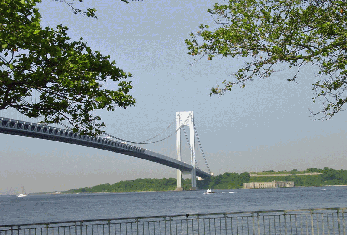
This 2004 photo shows the Bear Mountain Bridge (US 6 and US 202) from the western shoreline, just above the Orange-Rockland county line. (Photo by C.C. Slater.)
|
|
|
|
|
|
|
|
|
 |
|
|
|
|
 |
|
|
|
|
|
|
|
|
Type of bridge:
Construction started:
Opened to traffic:
Length of main span:
Length of side spans:
Length, anchorage to anchorage:
Width of bridge:
Width of roadway:
Number of traffic lanes:
Clearance at center above mean high water:
Number of cables:
Diameter of each of two cables:
Length of each cable:
Total number of wires in each cable:
Total length of wires:
Cost of original structure:
|
|
|
|
|
|
|
|
|
Suspension
March 22, 1923
November 26, 1924
1,632 feet (497.4 meters)
351 feet (107.0 meters)
2,332 feet (710.8 meters)
50 feet (15.2 meters)
40 feet (12.2 meters)
2 lanes
135 feet (41.1 meters)
2 cables
18 inches (45.7 centimeters)
2,600 feet
7,452 wires (792.5 meters)
7,377 miles (11,872 kilometers)
$4,500,000
|
|
|
|
|
|
|
|
|
|
|
|
|
|
 |
|
|
|
|
|
|
|
|
Passenger car cash toll (eastbound only):
Passenger car EZ-Pass toll (eastbound only):
|
|
|
|
|
|
|
|
|
$1.75
$1.35
(Commuter discounts available for frequent users.)
|
|
|
|
|
|
|
|
|
|
|
|
 |
|
|
|
|
 |
|
|
|
|
|
CROSSING THE HIGHLANDS: The Bear Mountain Bridge, the southernmost crossing administered by the New York State Bridge Authority, carries US 6 and US 202 across the Hudson River, from Bear Mountain State Park at the northern tip of Rockland County to the northwestern corner of Westchester County. On the western approach, which actually lies in Orange County (the Orange-Rockland border runs diagonally between the toll plaza and the superstructure), the bridge connects to US 9W and the Palisades Interstate Parkway. On the eastern approach, the bridge connects to NY 9D.
|
|
|
|
|
|
|
|
|
|
|
|
|
|
Plans for the bridge date as far back as 1868, when the first charter for a railroad bridge was obtained. The initial proposal by General Edward W. Serrell, which was featured in a Harper's Weekly article, employed a suspension span design similar to that of the Brooklyn Bridge. The truss-stiffened deck was to be supported over the Hudson River by four main cables and two masonry towers. Despite three attempts at starting construction, none of them got past the initial stages.
As the twentieth century began, private ferry companies initiated passenger service in the Highlands. When nearby Bear Mountain State Park opened in 1916, it quickly became a popular destination for New Yorkers. Before long, getting to and from the park meant long delays at the ferry terminal, or during nighttime or winter periods, not getting across at all. Even when they were available, ferries crossing the river between Peekskill and Bear Mountain State Park had waits of as much as four hours.
In February 1922, a bill was introduced in the New York State Legislature that authorized the creation of a privately financed entity, the Bear Mountain Hudson Bridge Company, to build a vehicular bridge across the Hudson at Bear Mountain. Under the terms of this bill, the company was given 30 years to build and maintain the bridge and highway approaches on state-owned land, after which time the state would take over the bridge. The most practical location for a bridge was at the narrow entrance to the Highlands. (At that time, there were no fixed vehicular crossings of the Hudson River south of Albany.)
DESIGN AND CONSTRUCTION OF THE BRIDGE: The time limit on construction of the bridge meant that steel rather than masonry would have to be used. However, new developments in obtaining geological data and steel construction technology provided the time and cost efficiencies that eluded previous construction attempts.
There were also concerns about how the bridge and highway design would impact the beauty of the lower Hudson Valley. After criticism that the proposed bridge would look "in its wonderful setting of mountains and river, like a piece of tin frumpery," consulting engineer Howard C. Baird modified its design to better fit in its surroundings.
|
|
|
|
|
|
|
|
|
|
|
|
|
|
|
|
|
Construction of the bridge began in March 1923. The anchorages that hold the two main steel cables were dug manually out of solid rock at a rate of approximately eight feet per week. The west anchorage was dug 110 feet into the rock, and the east anchorage 90 feet into the rock. Once the anchorages were completed in October 1923, work began on the two 351-foot-tall towers. The steel towers, which are supported by horizontal and diagonal braces rest on cast steel bases, which in turn rested on concrete piers (each measuring 20 feet by 50 feet) founded on rock near water level. The towers were completed in April 1924.
|
|
|
|
|
|
|
|
|
|
|
|
|
|
|
|
|
|
Next came the process of spinning the main and suspending cables. Each of the two 18-inch-diameter main cables was constructed from 7,452 individual galvanized wires. The total length of these wires measures 7,377 miles. Once the main cables were spun, the rock chambers and tunnels at the anchorages were filled with concrete to within a few feet of the cable connections, providing watertight protection for all the steel components of the anchorage chain.
When the cable-spinning process was completed in August 1923, work began on hoisting sections of the truss-stiffened deck above the Hudson River. Moving from the towers to the center of the river, crews used machines called travelers to hoist steel for the preliminary decking into place from barges that were waiting below. Once the travelers met at mid-river, they then returned to each shoreline, allowing workers to set the remaining floor components in place. Before the bridge was completed, workers put down the concrete for the four-lane roadway.
|
|
|
|
|
|
|
|
|
|
|
|
|
|
|
|
 |
|
 |
|
|
|
|
|
|
|
|
|
|
|
LEFT: This photo shows the start of cable spinning in April 1924, seven months prior to completion of the bridge. RIGHT: This 1925 photo shows the Bear Mountain Bridge shortly after its completion. The bridge was sold to New York State in 1940 after it failed to turn a profit for 16 years. (Photos from the Historic Bridges of the Hudson Valley archives; www.hbhv.org.)
|
|
|
|
|
|
|
|
|
|
|
|
|
|
|
|
|
|
|
|
CARVING AN APPROACH INTO A MOUNTAIN: Construction on the east highway approach - the two-lane Bear Mountain Bridge Road - began in April 1923. Beginning about three and one-half miles north of Peekskill, the new road continues for approximately three miles along the rugged slopes of the Manitou Hills. The winding road, which was cut into the southern face of Anthony's Nose, has an elevation of 410 feet.
|
|
|
|
|
|
|
|
|
|
|
|
|
|
A number of challenges were posed before the road's engineers. First, nearly the entire structure of the roadway required rock excavation and fill. Because the terrain was almost entirely granite, 70% of the material removed had to be drilled and blasted. Second, the construction site was hard to reach: access was only available at the eastern end of the road. Finally, steps had to be taken to ensure the safe and uninterrupted operation of the New York Central Railroad, whose Hudson Line tracks were situated below a one-mile stretch of the road.
The approach road was originally under the jurisdiction of the Bear Mountain Hudson River Bridge Company. A one-story tollhouse collected tolls regardless of whether or not motorists used the bridge. The collection of tolls purposely limited the use of the road because the bridge company would have been liable for any accidents. The tollhouse, which still stands today in the Town of Cortlandt, is a one-story Tudor-style building with a steep-gabled slate roof, an asphalt floor, exposed timbers and a stucco finish.
A TECHNOLOGICAL SUCCESS, BUT A FINANCIAL FAILURE: Less than two years after the first contract was signed, the Bear Mountain Bridge project, including the approach roads, was completed on September 10, 1924. It was formally opened to traffic on November 26, 1924. Remarkably, the $4.5 million project was completed without a single loss of life.
The Bear Mountain Bridge set new standards in engineering that ushered in a "golden age" of big bridge building that lasted through the 1920's and 1930's. When it opened, the Bear Mountain Bridge had the longest main suspension span in the world, surpassing that of the Williamsburg Bridge by 32 feet. It held its title for only two years, giving it up to the Benjamin Franklin Bridge across the Delaware River in Philadelphia in 1926.
The bridge was also intended to serve as an important link in the nascent Westchester County parkway system. To the east, the bridge approach road was to connect to the Bear Mountain State Parkway and the Bronx Parkway Extension (Taconic State Parkway), projects that were undertaken in the years following completion of the bridge.
Despite the bridge's technological success, it turned out to be a financial failure. During its first year, the bridge was expected to carry 5,000 vehicles per day. However, this volume did not materialize until later years. After operating at a loss for 13 out of the first 16 years, the Bear Mountain Bridge Company sold the bridge to the New York State Bridge Authority (NYSBA) for $2.3 million in 1940. Immediately, the toll was reduced from 75 cents to 50 cents in each direction, and in 1945, it was reduced again to 25 cents in each direction. The state also removed the toll from the eastern approach road in Westchester County.
THE BEAR MOUNTAIN BRIDGE TODAY: According to the New York State Department of Transportation (NYSDOT), the Bear Mountain Bridge carries approximately 20,000 vehicles per day (AADT) over the Hudson River. In addition to carrying one 12-foot-wide lane in each direction for US 6 and US 202, the roadway has eight-foot-wide shoulders for pedestrians and cyclists that accommodate the Maine-to-Georgia Appalachian Trail. To discourage through trucks from using the bridge, the NYSBA prohibits rigs weighing more than 56 tons from using the span.
In 1999, the New York State Office of Parks, Recreation and Historic Preservation (NYSOPRHP) announced plans to restore the vintage tollhouse on Bear Mountain Bridge Road. In conjunction with the Town of Cortlandt, the state plans to rehabilitate the tollhouse for use as a visitor information and interpretive center, provide parking for cars and recreational vehicles and encourage access to the nearby Camp Smith Trail.
|
|
|
|
|
|
|
|
|
|
|
|
|
|
|
 |
|
|
|
|
|
|
|
|
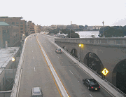
This 2004 photo shows the Bear Mountain Bridge (US 6 and US 202) from Bear Mountain State Park. The two-lane bridge also carries the Appalachian Trail. (Photo by C.C. Slater.)
|
|
|
|
|
|
|
|
|
|
|
|
|
|
|
|
|
|
|
 |
|
|
|
 |
|
|
|
|
|
SOURCES: "Proposed Suspension Bridge Over the Hudson River, Near Anthony's Nose, in the Highlands," Harper's Weekly (6/13/1868); "Peekskill Expects the Duke of York," The New York Times (8/17/1924); "Bridge Cables Finished," The New York Times (8/20/1924); "Builder Informally Opens Peekskill Scenic Highway," The New York Times (9/11/1924); "A Guide to Civil Engineering Projects in and Around New York City," American Society of Civil Engineers (1997); "$500,000 To Restore Historic Bear Mountain Bridge Site As Tourist Center," New York State Office of the Governor (10/14/1999); "Bridges Spanning the Hudson" by Krisy Nigro, Marist College (1999); Modjeski and Masters; New York State Bridge Authority; Dan Silverman; Christof Spieler.
US 6 and US 202 shields by Ralph Herman.
Lightposts by Millerbernd Manufacturing Company.
|
|
|
|
|
|
|
|
|
|
|
|
|
|
|
|
 |
|
 |
|
|
|
|
|
|
|
|
|
|
|
|
|
|
|
|
|
|
|
 |
|
|
|
|
|
|
|
|
 |
|
|
|
|
|
|
|
|
 |
|
|
|
|
|
|
|
|
|
|
|
|
Site contents © by Eastern Roads. This is not an official site run by a government agency. Recommendations provided on this site are strictly those of the author and contributors, not of any government or corporate entity.
|
|
|
|
|
|
|
|
|
|