 |
|
|
|
|
|
|
|
|
|
|
|
|
|
|
|
|
|
|
|
|
|
|
|
|
|
|
|
|
|
|
|
|
|
|
|
|
|
|
|
|
|
|
|
|
|
|
|
|
|
|
|
|
|
|
|
|
|
|
|
|
|
|
|
|
|
|
|
|
|
|
|
|
|
|
|
|
|
|
 |
|
|
|
|
 |
|
 |
|
|
|
|
|
|
|
|
|
|
|
|
|
|
|
|
 |
|
|
|
|
|
|
|
|
|
|
|
|
|
|
|
 |
|
|
|
|
|
|
|
|
|
|
|
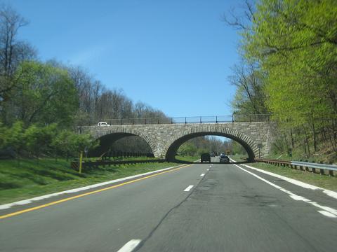
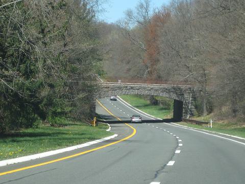
This 2016 photo shows the northbound Palisades Interstate Parkway at the Ludvigh Road overpass in Bardonia, New York. (Photo by Steve Anderson.)
|
|
|
|
|
|
|
|
|
 |
|
|
|
|
 |
|
|
|
|
|
|
|
|
Length:
Constructed:
NJDOT Reference Route:
NYSDOT Reference Route:
|
|
|
|
|
|
|
|
|
38.3 miles (61.6 kilometers)
1947-1958
NJ 445
NY 987C
|
|
|
|
|
|
|
|
|
 |
|
 |
|
|
|
|
|
Passenger cars only. Height restrictions apply.
|
|
|
|
|
|
|
|
|
|
|
|
|
|
|
|
|
|
|
|
|
|
|
THE PALISADES INTERSTATE PARK COMMISSION'S EARLY INITIATIVES: During the second half of the nineteenth century, the Palisades - a 550-foot-high precipice along the west bank of the Hudson River in Bergen County, New Jersey and Rockland County, New York - was threatened by development and extensive quarrying. The scenic view of the Palisades from New York City and Westchester County drove many people, particularly wealthy landowners, to demand that the government take measures to protect the Palisades.
To respond to this threat, the Palisades Interstate Park Commission (PIPC) was formed in 1900 by the New York and New Jersey state legislatures "to provide for the selection, location, appropriation and management of the certain lands along the Palisades of the Hudson River for an interstate park". The park stretched along the cliffs for 14 miles between Fort Lee, New Jersey and Piermont, New York. The first step in this preservation effort was the acquisition of the Carpenter Brothers trap rock quarry in Fort Lee, New Jersey for $132,500, most of which was donated by J.P. Morgan.
Initial access to the new Palisades Interstate Park was provided only by trans-Hudson ferries and poor local roads. As the park attracted more visitors, the need for more landing facilities, recreational areas and improved roads soon became apparent. In 1903, Charles W. Leavitt, Jr., the chief engineer of the PIPC, proposed the Henry Hudson Drive, a "rustic roadway many miles in extent, with a river view at all points," along the length of the Palisades. Although Leavitt proposed his route at the base of the Palisades, his provisions for a north-south route for commuters and park users, and for connections between park sections, were precursors for the design of the Palisades Interstate Parkway. Leavitt's Henry Hudson Drive, which opened in sections between 1921 and 1926, spanned seven miles from Fort Lee to Alpine, New Jersey. The 24-foot-wide concrete roadway was flanked by square curbs, grass shoulders and three-foot retaining walls.
Even as the Henry Hudson Drive was being planned, influential residents stopped the route of the road north of Alpine. In 1914, the PIPC hired E.A. Bennett, a city planner and landscape architect, to plan a new north-south road between New York and Albany. The new road, which was originally designated NJ 18-NY 3 and would later become US 9W, was to combine improved local roads and sections of new highway. It would provide river views throughout most of its length and offer a more direct route to the PIPC parks, which now included Bear Mountain and Harriman State Parks. By the time US 9W was completed in the late 1920s, both this route and the Henry Hudson Drive were exceeding their capacities.
|
|
|
|
|
|
|
|
|
|
|
|
|
|
|
|
|
|
|
|
 |
|
|
|
|
|
|
|
|
|
|
|
|
|
|
|
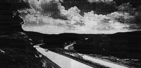
This 1958 photo shows the Palisades Interstate Parkway through Bear Mountain State Park. (Photo by Palisades Interstate Park Commission.)
|
|
|
|
|
|
|
|
|
|
|
|
|
|
|
|
|
|
THE REGIONAL PLAN: In 1928, the Regional Plan Association published an influential, multi-volume survey and planning study, Regional Plan for New York and Environs, that would shape the New York metropolitan area for decades to come. The study focused on developing regional road systems, including the development of limited-access express highway and parkways throughout the metropolitan area. Within the context of the plan, parkways were to serve two purposes. First, they were to connect residential areas with planned business and commercial centers. Second, they were also to serve as recreational facilities, incorporating parks, trails, picnic areas and scenic views.
Anticipating significant growth in Bergen, Passaic and Rockland Counties once the George Washington Bridge opened in 1931, the Regional Plan Association saw an urgent need to promote orderly development and improve transportation facilities while protecting the Palisades. To address these issues, the plan recommended a "Palisades Parkway" between Fort Lee, New Jersey and Bear Mountain, New York. The cost of land acquisition for the parkway was estimated between $25 million and $40 million.
THE PROPOSED PARKWAY: Influenced by the Regional Plan Committee's recommendation and encouraged by local authorities and newspapers, the PIPC undertook initial plans for the parkway. During 1933 and 1934, William A. Welch, the PIPC's chief engineer, prepared a "Parkway Plan" that included a suggested route for the parkway, a design concept and a strategy for accomplishing the project. The "Parkway Plan" recommended that the powers of the PIPC be expanded not only to constructing the parkway, but also to condemning adjacent properties along the right-of-way for parkland.
|
|
|
|
|
|
|
|
|
|
|
|
|
|
The Palisades Interstate Parkway proposal received a large boost from John D. Rockefeller, a philanthropist involved in public preservation efforts in the Hudson Valley. In 1933, Rockefeller donated 700 acres of land, which had an assessed value of $10 million, atop a 13-mile stretch of the New Jersey Palisades. The intentions of Rockefeller were specific:
My primary purpose in acquiring this property was to preserve the land lying along the top of the Palisades for any use not inconsistent with (the commission's) ownership and protection of the Palisades themselves. It has also been my hope that a strip of land of adequate width might be developed as a parkway, along the general lines recommended by the Regional Plan Association.
|
|
|
|
|
|
|
|
|
|
|
|
|
|
|
|
|
|
Once Rockefeller made his land offer, the PIPC authorized Welch to apply to the Federal Emergency Administration for construction funds. Although construction funds were not available, the parkway was accepted as a Civil Works Administration project, making it available for planning funds. Initially, the parkway received the support of politicians from both New York and New Jersey. However, when the New Jersey Highway Commission did not support immediate construction, New York State delayed construction funding, fearing that New Jersey would never make an interstate parkway possible.
Despite the deadlock, Rockefeller still held that the Palisades be preserved "perpetually for park purposes," and continued to press for construction of the Palisades Interstate Parkway. To preserve the natural skyline, he insisted that all buildings visible from the Hudson River be demolished. Working with master planner Robert Moses, he worked to establish the route and design of the parkway.
|
|
|
|
|
|
|
|
|
|
|
|
|
|
|
 |
|
|
|
|
|
|
|
|
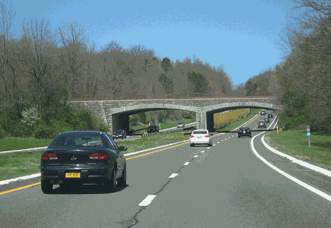
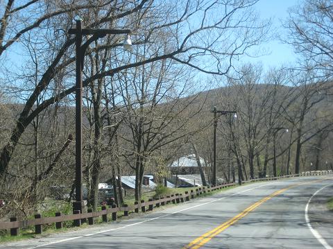
This 2016 photo shows the northbound Palisades Interstate Parkway at the Sickletown Road overpass in Tappan, New York. (Photo by Steve Anderson.)
|
|
|
|
|
|
|
|
|
|
|
|
|
|
|
|
|
|
THE PUBLIC RELATIONS BATTLE: Soon after the New York and New Jersey state legislatures authorized the PIPC to construct the Palisades Interstate Parkway in 1946, the PIPC began a long campaign to pitch the need for the parkway. Expanding from the original purpose of preserving the Palisades, Moses promoted the parkway as a "vital link" in the New York and New Jersey parkway system. To the south, the Palisades Interstate Parkway was to connect to the Garden State Parkway, extending the recreational corridor south to Cape May. (The Garden State Parkway connection was never built.) To the north and east, the Palisades Interstate Parkway was to connect to the Hudson Valley system of parks and parkways on both sides of the river. The proposed parkway, which was to connect the George Washington and Bear Mountain Bridges, was later planned to connect to the proposed New York State Thruway.
It did not take long for New York State to take action. Earlier, in 1943, the New York State Post-War Planning Commission had already included the parkway on its list of priority public works projects. In 1945, the state allocated $535,000 for right-of-way acquisition and $6 million for construction.
The battle for the parkway lasted longer along the New Jersey section. State and local politicians balked at the construction costs, which were estimated between $8 million and $10 million. They also feared that the land required for the parkway would add to the total exempt from taxation. To counter this argument, PIPC General Manager A. Kenneth Morgan, echoing the thinking of the Regional Plan Association, stated that the parkway would enhance property values in adjacent areas more than that which would lost along the parkway right-of-way.
Ironically, the strongest opposition came from those who wanted to "preserve the Palisades." Local conservationists feared that the parkway would spoil the park's charm, suggesting that the parkway be built outside the park. The major factor behind this opposition was private property holders, led by owners of two large parcels needed for the parkway. As opposition in the Garden State mounted, the PIPC was questioned by those in the Empire State, and Moses threatened to withdraw his support if the PIPC could not construct the parkway according to plan.
Under pressure from Moses, PIPC Chairman George W. Perkins, Jr. spearheaded an educational campaign to advance the Palisades Interstate Parkway proposal. In his position papers, "The Parkway Plan," Perkins argued that the parkway would make the pleasures of the Palisades - the undeveloped woodlands and the view of the Hudson River - easily accessible without compromising the natural character of the area. After several years of lobbying before civic groups and women's clubs, Perkins persuaded the New Jersey state legislature to act on the parkway. In April 1947, Governor Driscoll signed the appropriation bill placing the Palisades Interstate Parkway on the state highway system. As part of the bill, reimbursement would be provided to Bergen County municipalities that lost revenue due to land acquisition. By 1953, the last remaining parcels were condemned for the parkway right-of-way.
|
|
|
|
|
|
|
|
|
|
|
|
|
|
|
 |
|
|
|
|
|
|
|
|
Wide natural medians, such as that shown here in this 2016 photo in Alpine, New Jersey, provide a scenic buffer for the opposing carriageways. The historic Armstrong Tower (1938), which was used in pioneering FM radio broadcasts, is shown in the distance. (Photo by Steve Anderson.)
|
|
|
|
|
|
|
|
|
|
|
|
|
|
|
|
|
|
DESIGN CRITERIA: The Palisades Interstate Parkway incorporated advances developed over three decades of parkway design. There are two 12-foot lanes, one for each direction (northbound and southbound), with a provision for a third lane in each direction. Rights-of-way average 400 feet in width. To minimize headlight glare, opposing roadways are separated by wide, wooded medians, and where topographic conditions permit, by different levels. The parkway is designed with minimum sight distances of 1,000 feet, and banked horizontal curves of no less than 2,500 feet. With few exceptions, climbing and descending grades are held to four percent.
There are 43 grade separations (between roads) and 18 stream crossings along the route of the parkway. All bridges and culverts are rustic in design, incorporating the stone-arch design commonly found on the Moses-designed parkways. At interchanges, acceleration and deceleration lanes are provided. Cloverleaf interchanges are provided at high-volume locations.
The parkway is enclosed by a dense buffer of naturally occurring vegetation, including pine, locust, Forsythia, viburnum, wildflowers and annuals. The right-of-way is characterized by rugged terrain featuring a combination of natural and designed features, including wooded slopes, valleys, streams, open meadows and rock formations. In the southern section, where the right-of-way is narrow and the topography is flat, the layout of the parkway is more formal. The parkway takes on a more expansive, less formal layout in the northern section, where the dramatic landscape of Bear Mountain and Harriman State Parks becomes apparent.
Scenic overlooks and service areas are also incorporated into the parkway's design. Along the northbound lanes in New Jersey, there are three scenic overlooks in Englewood Cliffs (Rockefeller Overlook), Alpine and Palisades (State Line). At the State Line lookout, there is a one-story stone and timber restaurant and comfort station built in 1935. Four gas stations, all one-story buildings with sloping gable roofs, were built in Englewood Cliffs (one each along the northbound and southbound lanes), Palisades and at the Anthony Wayne Recreation Area. (The Anthony Wayne gas station was converted later into the PIPC Visitor Center.)
|
|
|
|
|
|
|
|
|
|
|
|
|
|
|
 |
|
|
|
|
|
|
|
|
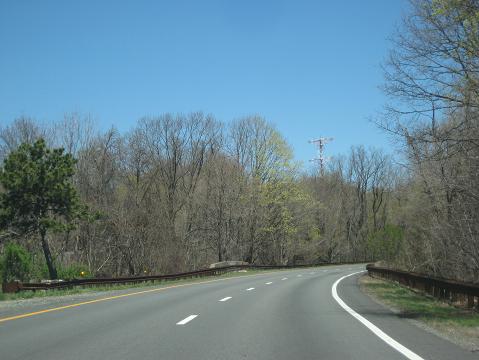
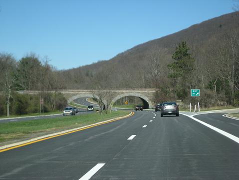
This 2016 photo shows the northbound Palisades Interstate Parkway at the NY 340 overpass in Palisades, New York. Instead of altering the contour of the land, the parkway takes advantage of these contours to provide an aesthetically pleasing ride for motorists. (Photo by Steve Anderson.)
|
|
|
|
|
|
|
|
|
|
|
|
|
|
|
|
|
|
|
|
|
|
|
|
|
|
|
|
CONSTRUCTION OF THE PARKWAY: Construction of the Palisades Interstate Parkway began on the New York section on April 1, 1947, and on the New Jersey section fourteen months later. Throughout the late 1940s and 1950s, the parkway opened as each section was completed. However, progress was delayed by material shortages following World War II and the Korean War.
The final section in New Jersey was completed at Alpine on June 22, 1957. On August 28, 1958, the final five-mile section in New York, between EXIT 5 (NY 303) in Tappan and EXIT 9 (I-87 / I-287 / New York State Thruway) in Nanuet, was opened to traffic. The total cost of the Palisades Interstate Parkway was $47.0 million, $15.8 million for the 11.5 miles in New Jersey and $31.2 million for the 30.5 miles in New York State.
The completion of the parkway was marked at a joint celebration held by Averell Harriman and Robert B. Meyner, the governors of New York and New Jersey. Robert Moses spoke of the parkway as follows:
Well, here we are again, with another stretch of the parkway that leads out of the cities and suburbs to the unspoiled open country. The parkway has been conceived, designed and built to higher than Roman standards, and people on foot and in care will enjoy it indefinitely. What more can we say of the preservation of the Palisades and the Ramapo Mountains? This indeed is the supreme gift of generous citizens to the people of the metropolitan area. Here the donors gave purchased immortality.
CHANGES IN DESIGN: Soon after the parkway opened, one interchange was changed from its original design. To accommodate the new four-mile-long Long Mountain Spur (US 6) connecting the Palisades Interstate Parkway with NY 293, the Queensboro Circle (EXIT 18) was constructed. Both the Long Mountain Spur and the Queensboro Circle interchange were built between 1957 and 1961. Originally, the design for the Queensboro Circle called for a three-level interchange, but the interchange design was determined to be incompatible with the location. Two new interchanges were built later at North Middletown Road (EXIT 10) and New Hempstead Road (EXIT 11).
Over the years, safety improvements have been implemented to accommodate higher speeds and increased traffic volume. The parkway originally was designed for a 40 MPH speed limit, but today the parkway speed limits are 50 MPH from the George Washington Bridge north to EXIT 9 (I-87 / I-287 / New York State Thruway), and 55 MPH from EXIT 9 north to the Bear Mountain Bridge. Acceleration and deceleration lanes have been lengthened. Moreover, a third lane was constructed in each direction for one mile north of the George Washington Bridge, in keeping with the original design of the parkway. (To date, construction of the third lane along the remainder of the parkway has been deemed unnecessary.)
Some small-scale features, such as the original black destination signs, wooden guard rails and "parkway-style" wooden lighting, have been lost. These features have been replaced by MUTCD-standard signs and metal guardrails. (The light standards were not replaced.)
|
|
|
|
|
|
|
|
|
|
|
|
|
|
|
 |
|
|
|
|
|
|
|
|
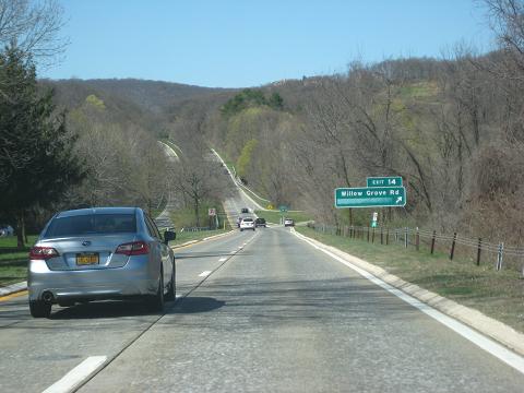
This 2016 photo shows the northbound Palisades Interstate Parkway at EXIT 14 (Rockland CR 98 / Willow Grove Road) in Willow Grove, New York. Here, motorists can enjoy vistas of Bear Mountain and Harriman State Parks. (Photo by Steve Anderson.)
|
|
|
|
|
|
|
|
|
|
|
|
|
|
|
|
|
|
THE PALISADES INTERSTATE PARKWAY, A NATIONAL LANDMARK: In 1998, the National Park Service nominated the Palisades Interstate Parkway in its National Register of Historic Places.
In their submission for the inclusion of the parkway in the National Register, Susan Smith, Regional Historic Restoration Coordinator for the Palisades Interstate Park Commission, and Kathleen LaFrank, Historic Preservation Resource Specialist for the New York State Office of Parks, Recreation and Historic Preservation, wrote the following summary:
The Palisades Interstate Parkway is exceptionally significant in the themes of conservation, recreation, transportation and regional planning for its role in the conservation of a significant endangered landscape, the development and promotion of recreation, and regional land use planning. The parkway is also significant in the areas of architecture, landscape architecture and engineering as an outstanding example of a post-World War II limited-access, scenic pleasure drive in New York and New Jersey. The period of significance recognizes the first major donation of land for conservation and parkway purposes in 1935, the continued acquisition of additional land over the next thirteen years and the construction of the parkway between 1947and 1961.The nomination also takes in several features that pre-date the period of significance. These have significance as they were reused or reinterpreted within the context of the parkway.
The Palisades Interstate Parkway marked the completion of a progressive and influential conservation project to preserve and restore the dramatic escarpment along the lower west bank of the Hudson River. Beginning in 1900 with the formation of the Palisades Interstate Park Commission (PIPC), the states of New York and New Jersey commenced a cooperative effort to acquire and preserve a large tract of the Palisades that was threatened by quarrying operations. A small portion of the Palisades Interstate Park (approximately 3,000 acres) has been recognized as a National Historic Landmark in the theme of conservation. Over the next fifty years, the PIPC acquired nearly 60,000 acres of parkland and developed a complex, influential and nationally significant conservation and recreation program.
By the late 1920s, one of the PIPC's most important concerns was the strip of land atop the escarpment, which remained in private hands and was increasingly threatened by burgeoning suburban development in the New York City metropolitan region. Based in part on recommendations contained in the Regional Plan for New York and Environs, a comprehensive regional planning study undertaken during the mid-1920s, the PIPC concluded that the construction of a parkway along the top of the cliffs was the most efficient, economical and permanent way to preserve and maintain the Palisades in their natural condition, "providing a convenient and safe means for people, while passing through, to see and enjoy the natural beauties without damaging that which they have come to see." Although it took the commission twenty years to acquire land and finance construction, the parkway was completed with its original goals and design standards. Described by its planners as a "continuous park" for pleasure cars, the Palisades Parkway combined conservation efforts with recreational, regional planning and transportation initiatives. The parkway provided metropolitan New Yorkers with convenient access to thousands of acres of parkland; it was planned as a major link in a recreation-transportation corridor that stretched from the southern tip of New Jersey to Bear Mountain State Park; it served to complete New York State's regional system of parks and parkways in the Hudson Valley; and it was an important regional planning initiative, encouraging orderly suburban growth while directing development away from the most fragile and scenic areas and preserving them for public benefit.
The Palisades Parkway is also an outstanding example of its type. Its design embodies the definitive characteristics of the limited-access scenic pleasure drive, repeating and improving upon the features of the parkways developed over the course of the first half of the twentieth century. The parkway is defined by restricted access, the elimination of cross traffic, a broad landscaped right-of-way, fully separated driving lanes at different elevations, generously banked curves, crisp sunken roadways defined by mountable curbs, contrasting tones and pavement and curbs, and connections to scenic and recreational attractions, both on the parkway and in the adjacent parkland. The design of the parkway is based on concepts developed by park personnel, regional planners, engineers, landscape architects and philanthropists. Among them, John D. Rockefeller, Jr. played a pivotal role in donating a significant amount of land and money, and facilitating the complex political process that brought the project to completin. Those sharing primary responsibility for developing the concept, route and design of the parkway include Major William A. Welch, a nationally known engineer and park designer who served as the PIPC's chief engineer for twenty-three years, the various planners and engineers of the Regional Plan Committee (including Jay Downer, chief engineer for the Bronx River Parkway), the well-known engineering firm of Amman and Combs, and the influential landscape architects and parkway designers Clarke, Rapuano and Holleran.
The Palisades Interstate Parkway is regarded as one of the finest examples of its type. It has been cited for its excellence by critics and historians, and has been called an "outstanding example" and a "triumph of understanding engineering
technically brilliant in design." Retaining a high level of functional and design integrity, the parkway continues to meet the goals of its designers.
|
|
|
|
|
|
|
|
|
|
|
|
|
|
|
 |
|
|
|
|
|
|
|
|
This 2016 photo shows the northbound Palisades Interstate Parkway at EXIT 19 (Seven Lakes Drive) near the northern terminus at Bear Mountain, New York. (Photo by Steve Anderson.)
|
|
|
|
|
|
|
|
|
|
|
|
|
|
|
|
|
|
CURRENT AND FUTURE IMPROVMENTS: According to the New Jersey Department of Transportation (NJDOT) and the New York State Department of Transportation (NYSDOT), the Palisades Interstate Parkway carries approximately 60,000 vehicles per day (AADT) through Bergen County and southern Rockland County, dropping to approximately 30,000 vehicles per day near its northern terminus. The NJDOT and the NYSDOT perform joint maintenance and construction work under the supervision of the PIPC.
Between 1999 and 2001, the NYSDOT, working under the supervision of the PIPC, rehabilitated the parkway from the New York-New Jersey border north to EXIT 10 (Rockland CR 33). The $54 million project included laying down new pavement, replacing the existing concrete ("Jersey") barriers with decorative stone-faced barriers, installing new natural-colored guardrails, and posting new MUTCD-compliant signs.
The following long-time projects have been scheduled on the Palisades Interstate Parkway:
Work to complete the rehabilitation of New York State's portion of the Palisades Parkway - from EXIT 10 north to the Bear Mountain Circle - will not begin until at least 2013, according to NYSDOT estimates. The $60 million project would include rehabilitation and replacement of the pavement and bridges, construction of new approaches and shoulders, relocation of drainage facilities, and additional operational and safety improvements.
The Port Authority still plans to build new ramps between the lower level of the George Washington Bridge and the Palisades Interstate Parkway. Currently, access to and from the parkway is only available to the upper deck of the bridge. Originally scheduled for construction between 2005 and 2009, this project has been postponed indefinitely.
|
|
|
|
|
|
|
|
|
|
|
|
The NYSDOT still plans to build a $6.5 million, ten-foot-wide bike path along the parkway right-of-way in Rockland County, though it was postponed from its original 2005 start date.
|
|
|
|
|
|
|
 |
|
|
|
|
|
|
|
|
|
|
|
|
|
|
 |
|
|
|
|
|
|
|
|
This 2016 photo shows an original parkway lightpost at Bear Mountain State Park. These wooden lightposts, which were used at the parkway's southern terminus and at parkway service areas, were removed in later years. (Photo by Steve Anderson.)
|
|
|
|
|
|
|
|
|
|
|
|
|
|
|
|
|
|
|
 |
|
|
|
 |
|
|
|
|
|
SOURCES: "Freeways Are Now Urged," The New York Times (12/13/1936); "The Parkway's Last Link" by Joseph C. Ingraham, The New York Times (8/24/1958); "Palisades Route Will Open Today," The New York Times (8/28/1958); "Palisades Interstate Parkway: Completion Story," Palisades Interstate Park Commission (August 1958); "Lake Welch Beach," Palisades Interstate Park Commission (June 1962); Public Works: A Dangerous Trade by Robert Moses, McGraw-Hill (1970); "Palisades Interstate Parkway: National Register of Historic Places Continuation Sheet" by Susan Smith and Kathleen LaFrank, Palisades Interstate Park Commission (February 1998); "Parkway Renovation a Decade Off" by Greg Clary, The Journal-News (4/02/2004); New York Metropolitan Transportation Council; David J. Greenberger; Ralph Herman; Raymond C. Martin; Nathan W. Perry; Denise Sullivan.
Palisades Interstate Parkway shield by Ralph Herman.
Bike route sign by Richard C. Moeur.
|
|
|
|
|
|
|
|
|
|
|
|
|
|
|
|
|
|
|
 |
|
|
|
|
|
|
|
|
|
 |
|
|
|
|
|
|
|
|
|
 |
|
|
|
|
|
|
|
|
 |
|
|
|
|
|
THE EXITS OF METRO NEW YORK:
Palisades Interstate Parkway exit list by Steve Anderson.
|
|
|
|
|
|
|
|
|
|
|
 |
|
|
|
|
|
|
|
|
 |
|
|
|
|
|
|
|
|
|
|
|
|
Site contents © by Eastern Roads. This is not an official site run by a government agency. Recommendations provided on this site are strictly those of the author and contributors, not of any government or corporate entity.
|
|
|
|
|
|
|
|
|
|