 |
|
|
|
|
|
|
|
|
|
|
|
|
|
|
|
|
|
|
|
|
|
|
|
|
|
|
|
|
|
|
|
|
|
|
|
|
|
|
|
|
|
|
|
|
|
|
 |
|
|
|
 |
|
 |
|
|
|
|
 |
|
 |
|
|
|
|
|
|
|
|
|
|
|
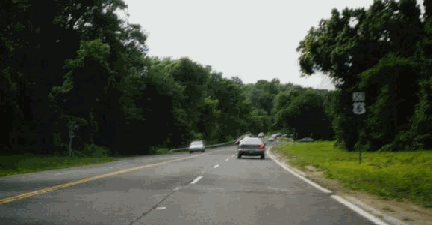
This 1998 photo shows the Bear Mountain State Parkway near its western terminus in Peekskill. Unlike the other Westchester parkways, the Bear Mountain Parkway has not had any significant structural changes over the years.(Photo by Steve Anderson.)
|
|
|
|
|
|
|
|
|
|
|
 |
|
|
|
|
 |
|
|
|
|
|
FROM THE TACONIC TO BEAR MOUNTAIN: Originally designated as the "Bronx Parkway Extension," the route of the Bear Mountain State Parkway was approved by the New York State Legislature in 1923 and later adopted by the Westchester County Parks Commission. Combined with the already completed section of the Bronx River Parkway, this parkway was to provide a scenic, rapid route from New York City to the Bear Mountain Bridge. When the parkway opened in 1932, promotional literature from the Parks Commission touted that motorists could travel between the two points in 45 minutes.
|
|
|
|
|
|
|
|
|
|
|
|
|
|
Extending north from the original terminus of the Bronx River Parkway in Valhalla, the "Bronx Parkway Extension" -- today known as the Taconic State Parkway -- continued north to Yorktown in northern Westchester County. From here, the "extension" diverged. For Putnam County and points north, motorists could continue north on the "Eastern State Parkway," which today is known as part of the Taconic State Parkway. For the Bear Mountain Bridge and points west of the Hudson River, motorists could continue west on the "extension," which later became known as the Bear Mountain State Parkway.
Like many Westchester parkways, this road was constructed as a "hybrid" at-grade and limited-access parkway. However, unlike the other parkways, the Bear Mountain State Parkway remains an undivided, four-lane arterial. Most maps place the name change to the "Bear Mountain State Parkway" sometime in the 1940's.
The Bear Mountain State Parkway was never completed in its entirety. Today, the parkway exists in two separate segments. The western 3.8-mile segment, which runs from the intersection of US 6-US 9-US 202 at the Janspeek Bridge (Annsville Creek) to Crompond Road (US 202), traverses the northern edge of the city of Peekskill. An eastern 0.9-mile segment connects the Taconic State Parkway (at Hunter Brook State Park) with Crompond Road (US 202) in the Town of Yorktown. Between these two segments, a gap of 1.8 miles remains. The right-of-way for the unbuilt section of the Bear Mountain State Parkway in the towns of Cortlandt and Yorktown remains set aside for its construction.
According to the New York State Department of Transportation (NYSDOT), the Bear Mountain State Parkway handles approximately 15,000 vehicles per day (AADT). Currently, the NYSDOT is rehabilitating the existing parkway section through Peekskill, from US 9 east to US 6-US 202-NY 35. The $10 million project is scheduled for completion in 2003.
CONVERTING AND EXTENDING THE BEAR MOUNTAIN PARKWAY: In 2000, the NYSDOT and the Westchester County Department of Planning proposed completing the "missing link" of the Bear Mountain State Parkway. The entire route, which today is restricted to passenger cars, would be converted for use to all vehicles. Visual and noise abatements, as well as the construction of a multi-use trail, would be integrated into the controlled-access "greenway" design.
On May 18, 2002, residents from Peekskill, Cortlandt and Yorktown met to discuss sustainable development on the Bear Mountain State Parkway and the US 6 / US 202 / NY 35 corridors. Residents from all three towns agreed on the need to fill in the missing link on the parkway, in order to relieve congestion on the existing US 6 / US 202 / NY 35. They also agreed on the need for interchange improvements on the parkway. However, they did not reach a consensus on allowing truck traffic on the corridor, voicing concerns about keeping the parkway aesthetically pleasing.
|
|
|
|
|
|
|
|
|
|
 |
|
|
|
|
|
 |
|
|
|
 |
|
|
|
|
|
|
|
In 1956, the Westchester County Planning Department proposed a new expressway along the US 6-US 202 corridor. The Peekskill-Brewster Expressway, which was to be a realignment and improvement of the existing US 6 and US 202, was to be signed as US 202 throughout its entire 20-mile length in Westchester and Putnam counties, and multiplexed with US 6 for 14 miles between the Bear Mountain Bridge and Baldwin Place.
|
|
|
|
|
|
 |
|
|
|
|
|
|
In its recommendation report, the planning department advocated the expressway as a medium-to-high priority corridor:
The expressway will provide connections among the Bear Mountain Bridge, the proposed US 9 expressway, the Taconic State Parkway and the proposed NY 22 expressway as the northernmost, cross-county thoroughfare. It will improve or replace portions of US 6 (in the Towns of Cortlandt and Yorktown), which will continue to be an important inter-county route regardless of whether or not it is relocated to the north of Westchester County in the future. Finally, the expressway will provide an east-west, mixed-traffic route to serve rapidly growing areas in Cortlandt and Yorktown.
|
|
|
|
|
|
|
 |
|
|
|
|
|
|
|
|
|
|
For the first section between the Bear Mountain Bridge and the city of Peekskill, two alternatives were chosen for the Peekskill-Brewster Expressway. Both alternatives would have provided four lanes.
The 4.5-mile-long northerly alternative would have followed the right-of-way of Bear Mountain Bridge Road (NY 9D) and South Mountain Pass in Putnam County to an intersection with the proposed US 9 expressway. It would have proceeded south along US 9 to Highland Avenue in Annsville, turned southeast across Sprout Brook and Peekskill Hollow Brook into the city of Peekskill, and veered east onto the right-of-way of the Bear Mountain State Parkway. Although this alternative was longer, it would have traversed land more favorable for road construction.
The 3.7-mile-long southerly alternative would have followed the right-of-way of US 6 and US 202 between the Hudson River and Camp Smith Military Reservation. At the intersection with the proposed Hudson River Expressway (US 9 / possible I-487), the proposed route would have crossed Annsville Creek before veering east along the Bear Mountain State Parkway right-of-way. Although this alternative would have required cutting and filling to eliminate steep grades and sharp curves, it would have produced a more scenic route. This section was to be constructed with each carriageway on separate levels.
The second 3.5-mile section between Peekskill and Yorktown was to parallel the right-of-way of the existing Bear Mountain State Parkway. The existing parkway was to be widened to six lanes and converted for use by commercial vehicles. The use of the parkway right-of-way would have minimized disruption in this corridor.
The next 5.4-mile section through the Town of Yorktown would have continued on the Bear Mountain State Parkway right-of-way to its intersection with the Taconic State Parkway. At this junction, another east-west thoroughfare, the Northern Westchester Expressway (NY 35), was to split off from this route and continue to the southeast. From this point, the proposed Bear Mountain-Croton Falls Expressway, which would have provided four lanes east of the Taconic State Parkway-NY 35 Expressway junction, was to continue northeasterly along a new alignment to Jefferson Valley (Lake Osceola), where it would have proceeded east along the US 6 corridor into the Town of Somers. Although there were no major topographical problems with this route, development in the path of the proposed route posed a potential problem.
The final 6.7-mile section of the expressway would have veered east of the existing US 6 alignment at Baldwin Place. It was to continue on a new right-of-way along a broad valley between Lake Lincolndale and Lake Shenorock to the Croton Falls area. Just northeast of Croton Falls, the US 202 Expressway was to meet the Eastern Corridor Expressway (today's I-684) near Brewster.
In 1966, officials from both the Westchester County Planning Department and the Tri-State Transportation Commission revived their recommendation for an expressway along the US 202 corridor. The US 202 Expressway, parts of which have been constructed in Pennsylvania, Connecticut and Massachusetts, would relieve congestion along the I-95 corridor and serve as a bypass around the cities of the Northeast.
Although this section of the Peekskill-Brewster Expressway was never constructed, a proposed US 202 Expressway along the Northeast Corridor has been the topic of ongoing discussion in the newsgroup misc.transport.road.
|
|
|
|
|
|
|
|
|
|
|
 |
|
|
|
|
 |
|
|
|
|
|
|
|
|
 |
|
|
|
|
|
SOURCES: Reports of the Westchester County Parks Commission (1926-1935), Westchester County Parks Commission (1935); "Preliminary Plan for Major Thoroughfares in Northern Westchester," Westchester County Planning Department (1956); "Westchester Maps Need for More Roads" by Merrill Folsom, The New York Times (4/28/1966); Transportation 1985: A Regional Plan, Tri-State Transportation Commission (1966); "East Hudson Parkway Authority: Annual Report," East Hudson Parkway Authority (1977); New York Metropolitan Transportation Council; New York State Department of Transportation; Westchester County Department of Planning; Peter Cooper; Ralph Herman; Ben Holmberg; Nathan W. Perry.
Bear Mountain State Parkway, US 6, and US 202 shields by Ralph Herman.
Lightpost by Jeff Saltzman.
|
|
|
|
|
|
 |
|
|
|
|
|
|
|
|
|
 |
|
|
|
|
|
|
|
|
|
 |
|
|
|
|
|
|
|
|
|
 |
|
|
|
|
|
THE EXITS OF METRO NEW YORK:
Bear Mountain State Parkway exit list by Steve Anderson.
|
|
|
|
|
|
|
|
|
|
|
 |
|
|
|
|
|
VIEW OR SUBMIT YOUR RATING TO RATETHEROADS.COM:
Bear Mountain State Parkway
|
|
|
|
|
|
|
|
|
|
|
|
 |
|
|
|
|
|
|
|
|
|
|
 |
|
|
|
|
|
|
|
|
|
|
|
|
|
|
Site contents © by Eastern Roads. This is not an official site run by a government agency. Recommendations provided on this site are strictly those of the author and contributors, not of any government or corporate entity.
|
|
|
|
|
|
|
|
|
|