
|
|
||
|
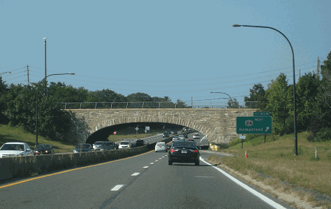
This 2014 photo shows the Wantagh State Parkway at EXIT W3 (NY 24 / Hempstead Turnpike) in Levittown. The davit lightpoles shown here, which were installed in 2012, represent the third generation of lightpoles along this segment. (Photo by Steve Anderson.) |
||
|
Length: |
||
|
13.3 miles (21.4 kilometers) |
||
|
Passenger cars only. Height restrictions apply. |
||

|
THE FIRST PARKWAY TO JONES BEACH: In 1927, ground had broken on one of the earliest of the Long Island parkways, the Wantagh State Parkway. Two years later, the initial five-mile segment of parkway from EXIT W6 (Merrick Road) in Wantagh south to Jones Beach State Park was completed. The completion of this section of the Wantagh State Parkway coincided with the opening of Jones Beach, which was named after Major Thomas Jones, an Irish immigrant and privateer who in 1692 established a whaling station in the area. |
||
|
Originally known as the "Jones Beach Causeway," the initial section of the Wantagh State Parkway was constructed on hydraulic fill across the islands of Great South Bay and marshes on lands donated to the state by the Town of Hempstead. The forty-foot-wide pavement carried two northbound and two southbound lanes, with no separating barrier. |
||
|
The Northern State-Wantagh State Parkway is the final link in a forty-three mile express road from the Triborough Bridge to Jones Beach. Those parkways built ten years ago for example are in some respects obsolete... (The new design) includes every device and detail experience has shown to be effective. Included among them are grade-separated crossings, dark-colored pavement (for contrast with light-colored acceleration and deceleration lanes), funnel entrances, sloping curbs and wide level shoulders. These details have been used before, extensively, or in trial installations. They are all brought together for the first time in the Northern-Wantagh Parkway. |
||
|
The 1938 section reflected state-of-the-art highway design, setting the standard for future parkways on Long Island. It was constructed with two 25-foot-wide roadways carrying two lanes in each direction, each roadway separated by a nine-foot grassed median. Mountable three-inch-high allowed disabled motorists to move easily move off the parkway onto the shoulders. Uncolored acceleration and deceleration lanes, which contrasted with the dark-colored, through travel lanes, guided motorists through interchange areas. |
||

|
This 2002 photo shows the Wantagh State Parkway at the Jerusalem Avenue overpass (NY 105), just south of EXIT W4 (Southern State Parkway). (Photo by Jon Lebowitz.) |
||

|
IMPROVEMENTS TO THE PARKWAY: Between 1955 and 1967, the Wantagh State Parkway was widened to three lanes in each direction between Jones Beach and the Southern State Parkway. To comply with the safety standards implemented on the other parkways, the two opposing roadways were now separated by a ten-foot-wide grassed median. This expansion was financed by Jones Beach State Parkway Authority bonds. |
||
|
In 1977, maintenance of the Wantagh State Parkway was transferred from the LISPC to the New York State Department of Transportation (NYSDOT), although ownership remained under the jurisdiction of the New York State Office of Parks, Recreation and Historic Preservation (NYSOPRHP). To accommodate the increase in traffic volume and speed, and to address the accident history, the NYSDOT began to modify the parkway in accordance with Federal and state traffic safety guidelines. Soon thereafter, tolls were removed for motorists using the Wantagh Causeway in the area of Jones Beach. |
||
|
THE PEDESTRIAN AND CYCLING PATH: When the Jones Beach Causeway opened in 1929, a pedestrian and cycling path was constructed along the northbound lanes of the causeway from Jones Beach north to Merrick Road. This path was eventually extended all the way north to the Northern State Parkway in 1938, when the remainder of the Wantagh State Parkway was completed. |
||

|
Over the years, subsequent roadway widening projects have severed the original path north of Merrick Road. However, the NYSDOT committed to restoring the path by allocating $4.2 million to restore and expand the existing path in 2006. |
||
|
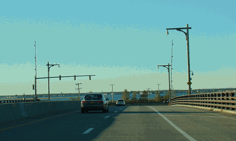
This 2015 photo shows the northbound Wantagh State Parkway at the rebuilt Sloop Channel Drawbridge. (Photo by David Golub, www.eastcoastroads.com.) |
||

|
PROPOSED EXTENSION TO OLD WESTBURY: In the late 1950's, New York State Department of Public Works (NYSDPW) acquired the right-of-way for an extension of the Wantagh State Parkway north to the Long Island Expressway (I-495), where it would meet between EXIT 39 and EXIT 40 in Old Westbury. According to the 1959 Nassau County Master Plan, the Wantagh Parkway extension was to include a full "diamond" interchange at NY 25 (Jericho Turnpike) in Westbury. At the LIE, there was to be a partial interchange (EXIT 39A) where the northbound Wantagh Parkway exits onto the westbound LIE, and the eastbound LIE exits onto the southbound Wantagh Parkway. |
||
|
Later, in its 1970 master transportation plan, the Nassau-Suffolk Regional Planning Board recommended the northward extension of the Wantagh State Parkway to Old Brookville, near the intersection of NY 25A and NY 107. The planning agency intended the parkway extension to serve SUNY-Old Westbury, the New York Institute of Technology at Old Westbury, and the C.W. Post campus of Long Island University in Old Brookville. |
||
|
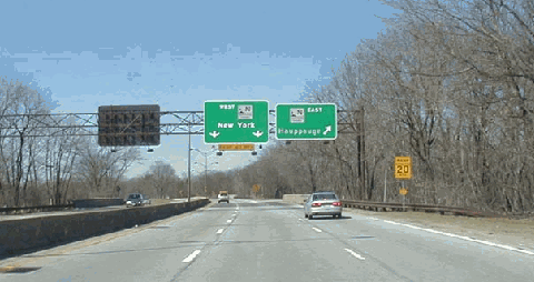
This 2001 photo shows the northern terminus of the Wantagh State Parkway at the Northern State Parkway in Westbury. Since the late 1950's, attempts to extend the Wantagh State Parkway north into Old Westbury and Old Brookville have been met with stiff resistance. (Photo by Mike Tantillo.) |
||

|
The Wantagh State Parkway should be widened to six lanes between the Southern State Parkway in Wantagh and the Northern State Parkway in Westbury. In some locations, older, tighter cloverleaf interchanges should be replaced with four-ramp diamond interchanges. New lighting also should be installed south of the Southern State Parkway. |
||

|
SOURCES: "New Highways Across Long Island To Link North and South Shores," The New York Times (11/15/1936); "Master Plan for Nassau County," Nassau County Department of Public Works (1959); "Long Island Regional Transportation Plan," Nassau-Suffolk Regional Planning Board (1970); The Power Broker by Robert A. Caro, Vintage Books-Random House (1974); Maintaining Mobility, Tri-State Regional Planning Commission (1975); History of the Long Island State Parkway System, New York State Department of Transportation (1985); "Ways To Go" by Alison Mitchell, Newsday (9/21/1986); "Jones Beach Causeway Bridge" in Historic American Engineering Record, National Park Service (1987); Robert Moses: Single-Minded Genius by Joann P. Krieg, Heart of the Lakes Publishing (1989); "LI's Roads in a Big Jam" by Tom Morris, Newsday (2/22/1990); "Extension of Three Expressways Urged" by Monte R. Young, Newsday (2/22/1990); "Wantagh Parkway Detours" by John M. Gonzale, Newsday (4/08/1998); "Wantagh Parkway Beach Route Closed" by Irving Long, Newsday (4/13/1998); "Tidal Scour at a State Highway Bridge," U.S. Geological Survey (1999); "Ask Dr. Conehead" by Kim Nava-Fiorio, Newsday (2/25/2001); "Ask Dr. Conehead" by Kim Nava-Fiorio, Newsday (12/21/2003); "Bridge Engineer Contends with Troubled Water and Much More" by John Valenti, Newsday (6/12/2005); New York Metropolitan Transportation Council; Cynthia Blair; Daniel T. Dey; Ralph Herman; Nathan W. Perry; Dan Salomon; Mike Tantillo; Jim Wade. |
||

|
WANTAGH STATE PARKWAY LINKS: |
||
|
WANTAGH STATE PARKWAY CURRENT TRAFFIC MAPS: |
||
|
WANTAGH STATE PARKWAY VIDEOS: |
||

|
THE EXITS OF METRO NEW YORK: |
||

|
Back to The Roads of Metro New York home page. |
||
|
Site contents © by Eastern Roads. This is not an official site run by a government agency. Recommendations provided on this site are strictly those of the author and contributors, not of any government or corporate entity. |
||