 |
|
|
|
|
|
|
|
|
|
|
|
|
|
|
|
|
|
|
|
|
 |
|
|
|
|
|
|
|
The following historical piece was compiled by the New York State Department of Transportation and The Museums at Stony Brook in 1985. It is published in its entirety with permission.
|
|
|
|
|
|
|
|
|
|
 |
|
|
|
|
|
 |
|
|
|
|
|
|
|
|
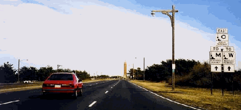
This 1998 photo shows the eastbound Ocean Parkway at Jones Beach, approaching the Jones Beach Water Tower and the Wantagh State Parkway. (Photo by Steve Anderson.)
|
|
|
|
|
|
|
|
|
|
|
|
|
|
|
|
|
|
INTRODUCTION
"What gives New York most distinction in its travel routes throughout the country, and perhaps throughout the world, is its parkways
" This passage, written in 1940 by the Writers' Program of the Work Projects Administration in its publication, New York: A Guide to the Empire State, reflects the engineering and aesthetic success at that time of the New York metropolitan area's extensive, and still evolving, parkway system. This system had its beginnings in the Bronx River Parkway (1906-1925), developed in part as a result of the burgeoning public parks and conservation movement, and the increasing availability and technological advances of the automobile. The Bronx River Parkway proved to be not only an engineering success, but also a new expression of uniquely American landscape architecture. As historian and critic Sigfried Giedion noted regarding the early twentieth-century American parkway in his work Space, Time and Architecture:
But it was not, like certain Continental highways, laid out for military purposes, driven rigidly through the country in dangerously straight lines. Nor was it, like a railway, built to provide the most direct and rapid transit. Instead it humanized the highway by carefully following and utilizing the terrain, rising and falling with the contours of the earth, merging completely into the landscape.
This natural relationship with the land, along with ample landscaped rights-of-way, grade-separated crossings, limited access points, picturesque masonry bridges, naturalistic plantings and vistas, and rustic roadside features, became the hallmark of the Bronx River Parkway and its progeny.
DEVELOPMENT OF THE LONG ISLAND PARKWAY SYSTEM
The Long Island Parkway System, which was part of the first generation of parkways constructed after the Bronx River Parkway, traces its beginnings to the organization of a Long Island State Park Commission (LISPC) in 1924. One of the three commissioners named in 1924 was Robert Moses, who served continuously until 1963, and was the single most influential person in its development. It was Robert Moses who was the primary force behind the plan to create a system of efficient, scenic parkways to replace the increasingly congested and unattractive local roads. Although Robert Moses is credited as the force behind the development of the parkways, other designers were involved, most notably Clarence C. Coombs.
The Long Island Parkway System was envisioned as great ribbon parks, stretching east-west and north-south across Long Island, providing scenic access and linkage between the state parks then under development, such as Jones Beach, Bethpage and Sunken Meadow. The Long Island Parkway System followed the same design characteristics as the parks themselves, the two visually linked through common design. The system employed stone-faced arched bridges, turf shoulders, bracketed-arm wood light posts, post-and-rail fences and guide rails, naturalistic road alignments and plantings, and unobtrusive black-faced signs.
|
|
|
|
|
|
|
|
|
|
|
|
|
|
By 1927, the basic plan for the Long Island State Parks and Parkway System was linked with a similarly designed system in Brooklyn and Queens, also under the direction of Robert Moses but developed through the New York City Parks Department. By the summer of 1929, Jones Beach State Park and Ocean Parkway opened, connected with the mainland by the Jones Beach Causeway (Wantagh State Parkway), and to New York City by the Southern State Parkway. These were soon followed in the 1930's by the Long Beach Causeway (Loop Parkway), and by the Northern State, Meadowbrook, Bay and Bethpage Parkways. Construction followed the design guidelines set down by the LISPC, but was undertaken by other departments and special authorities, such as the State Department of Public Works and the Jones Beach State Park Authority.
|
|
|
|
|
|
|
|
|
|
|
|
|
|
|
|
|
|
Construction followed the design guidelines set down by the LISPC, but was undertaken by other departments and special authorities, such as the State Department of Public Works and the Jones Beach State Park Authority. In 1940, the Long Island at the Fair Committee proudly provided the following description of the parkway system to visitors at the New York World's Fair:
Parkways created by and under the supervision of the Long Island State Park Commission are of the same high standard as the parks and no less useful to the public. The parkway system is designed to furnish access to individual parks from congested centers of population, and to provide for travel between New York City's centers and outlying Long Island without interference from commercial traffic
Skilled landscaping has made them attractive to the eye, and engineering ability makes them safe arteries of rapid travel.
The overall design that gave the Long Island Parkway System its unique and very identifiable character was used continuously from the earliest parkways of the late 1920's, to its completion in the mid 1960's. Maintenance was undertaken by the LISPC, as well as by related authorities (including the Jones Beach, Meadowbrook, Wantagh, and Robert Moses authorities) with jurisdiction over the various causeways.
|
|
|
|
|
|
|
|
|
|
|
|
|
|
|
 |
|
|
|
|
|
|
|
|
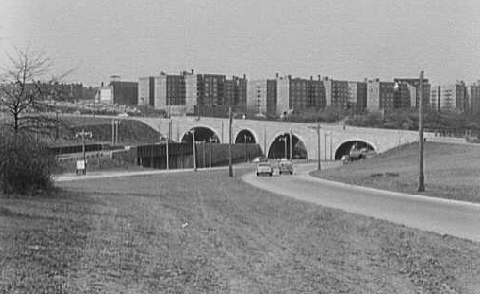
This 1955 photo shows the four-arched stone overpass that carries Union Turnpike over the Grand Central Parkway, at the Kew Gardens interchange. (Photo by Gottscho-Schleisner, Inc., photographers.)
|
|
|
|
|
|
|
|
|
|
|
|
|
|
|
|
|
|
CHANGES IN PARKWAY DESIGN
Initial changes to the parkways generally followed the original design. However, the earliest parkways tended to be two-lane undivided roadways, while those built during the 1930's introduced divided roadways with wide turf medians and improved ramps.
As suburban development and the reliance upon the automobile for transportation increased following World War II, the Long Island Parkway System came under pressure to serve not only increasing recreational use, but also much greater commuter traffic. In the post-World War II period, the early undivided parkways were widened to accommodate greater volumes. Guide rails, medians, travel lanes and bridges were enlarged and updated to reflect improved safety techniques and accommodate higher speed limits. General speed limits, originally set at 40 MPH, were raised to 45 MPH in 1959, 50 MPH in 1963, and 55 MPH in 1974. While engineering improvements and other design specifications (such as the proportions of the light poles and the details of the median barriers) were modified over time, a strong design continuity remained.
In 1977, maintenance of the Long Island Parkway System was transferred from the LISPC and the authorities to the New York State Department of Transportation (NYSDOT), although ownership remained under the jurisdiction of the New York State Office of Parks, Recreation and Historic Preservation (NYSOPRHP). To accommodate the increase in traffic volume and speed, and to address the accident history, the NYSDOT began to modify the parkways in accordance with federal and state traffic safety guidelines. Light fixtures, guide rails and barriers were removed and/or replaced, new signs added, and some shoulders paved in accordance with the federal and state highway standards. Alterations were most severe on the east-west parkways. The southern end of the primarily north-south parkways experienced fewer modifications.
NATIONAL REGISTER ELIGIBILITY DETERMINATION
On February 13, 1987, the NYSOPRHP determined that the Meadowbrook State Parkway (south of the Southern State Parkway), Wantagh State Parkway (south of the Southern State Parkway), Ocean Parkway, Loop Parkway, Bay Parkway and Bethpage State Parkway, retained sufficient historic integrity to be eligible for inclusion in the State and National Register of Historic Places. These National Register-eligible "Robert Moses Historic Long Island Parkways," which comprise approximately 34 miles of the approximately 132-mile original Long Island Parkway System, are eligible to the National Register under the following criteria:
Associated with events that have made a significant contribution to the broad patterns of our history.
Associated with lives of persons significant in our past.
Embodies the distinctive characteristics of a type, period or method of construction, or represents the work of a master.
In their eligibility statement, the NYSOPRHP commented that the "Historic Long Island Parkways" have significance within the categories of transportation, landscape architecture, community and regional planning, and for their association with Robert Moses' ambitious plans for the Long Island Park System. The NYSOPRHP summarized the significance of the "Historic Long Island Parkways" in an attachment to their February 13, 1987 letter as follows:
The Long Island Parkways have significance within the categories of transportation, landscape architecture, community and regional planning, and for its association with Robert Moses' ambitious plans for the Long Island State Park System.
The parkway system was designed and executed by Robert Moses, one of the most influential planners of the early 20th century and first president of the Long Island State Park Commission (1924).
Moses specifically chose Long Island as the site for his "dreamscape" which "combined conservation with the idea of recreation in the form of state parks connected to scenic roadways (the parkways or linear parks) that themselves would by park-like." This concept was implemented throughout the 1920's and 1930's, and originally consisted of a total of 11 parkways connecting numerous parks. Not only were the parkways landscaped with lawn, shrubs and trees, but Moses also designed the street lamps and bridges to complement these scenic roadways.
|
|
|
|
|
|
|
|
|
|
|
|
|
|
|
 |
|
|
|
|
|
|
|
|
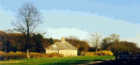
A parkway gas station lies abandoned in the center median of the Northern State Parkway in Dix Hills, Suffolk County, between EXIT 42 and EXIT 43. When the parkways were constructed by Robert Moses, stone-faced service stations were placed along the routes in New York City, Long Island and Westchester. Most of the stations were closed in the 1970's and 1980's. Only a few stations remain in operation: along the Grand Central Parkway in East Elmhurst and Holliswood; along the Belt Parkway in Brooklyn; and along the Hutchinson River Parkway in the Bronx and White Plains. (Photo by Steve Anderson.)
|
|
|
|
|
|
|
|
|
 |
|
|
|
 |
|
|
|
|
|
|
|
|
|
|
|