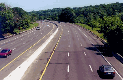
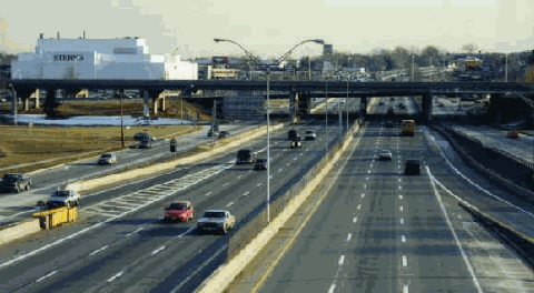
This 1998 photo shows the northbound New York State Thruway (I-87) in Ardsley, just south of EXIT 8 (I-287 / Cross Westchester Expressway). (Photo by Jeff Saltzman.)
PLANNING "THE MAIN STREET OF NEW YORK STATE": As early as 1949, highway officials proposed a toll superhighway connecting the major cities of New York State. The proposed New York State Thruway was to be part of a 1,780-mile network of "interstate and interregional" expressways. The early thruway plan had the toll road cross the Hudson River at the proposed Newburgh-Beacon Bridge (I-84). Later plans had the thruway cross at the proposed Tappan Zee Bridge (I-87 and I-287).
In 1950, the New York State Legislature created an independent public corporation to build, operate and maintain a superhighway network across New York State. The newly created New York State Thruway Authority (NYSTA) was given the authority to issue bonds for construction of the Thruway system as a self-liquidating project. These bonds were to be financed from the proceeds from tolls, rents, concessions and other income.
The tolls were to be comprised of barrier systems in urban areas, and a long-distance ticket system through rural areas. The NYSTA considered implementing thruway road use tags to be paid through annual fee, but this arrangement was not found to raise adequate revenue.
The Thruway Authority Act of 1950 provided geographical names for each of the Thruway's sections: Southern Westchester, Hudson, Catskill, Mohawk, Ontario, Erie, Berkshire, New England and Niagara. Subsequent legislation also named these sections for old Indian trails: the Iroquois Trail (the mainline between New York City and Buffalo), the Erie Path (the Erie Extension), the Mohican Path (the New England Thruway), the Algonquin Path (the Berkshire Extension) and the Tuscarora Path (the Niagara Extension).
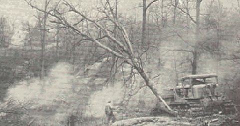
This 1953 photo shows clearing along the New York State Thruway right-of-way at Palmer Road in Yonkers. (Photo from "This Is Westchester" supplied by James Rumbarger.)
DESIGN AND CONSTURCTION: In 1951, the NYSTA issued the following design guidelines for the New York State Thruway:
As a limited-access expressway of the most modern design, the thruway will have no crossings at grade, and vehicles will enter and leave only at designated interchange points. The roadway will be constructed initially to provide six traffic lanes in some sections and four lanes in others, but all sections will be planned for an ultimate six lanes. Lane widths will be 12 feet to 13 feet, and a center mall at least 20 feet wide will be provided between opposing directions of traffic. Minimum right-of-way width is 200 feet.
The design speed for the thruway is 70 miles per hour. The specifications call for gradual curves with minimum radii of 2,800 feet, grades no steeper than three percent, and minimum sight distances of 1,000 feet. At entrance and exit points, acceleration and deceleration lanes 1,200 feet long and 12 feet wide will be provided.
Bertram Tallamy, the commissioner of the NYSTA, personally selected blue signs with white lettering for the Thruway's exit and destination signs. This original sign color scheme, which Tallamy believed would be most legible for the average motorist from at least 800 feet, was also used on the Connecticut Turnpike.
However, when new Interstate signing standards were developed in the late 1950's, the American Association of State Highway Officials (AASHTO) rejected Tallamy's color scheme in favor of the current white-on-green scheme. It was revealed later that Tallamy suffered from severe color blindness: for him, the green background of the new Interstate signs was a pale yellow. In later years, the original blue thruway signs were replaced with more standardized green signs.
Landscaping also reflected 1950's design ideals. Billboards and other advertising devices were prohibited within 660 feet of the thruway right-of-way. Wherever possible, trees and native grasses were planted along the route.
THE THRUWAY OPENS: Construction of the New York State Thruway mainline between the New York City line and Buffalo progressed as follows:
Lowell to Rochester (115 miles) .. June 24, 1954 Rochester to Buffalo (63 miles) .. August 25, 1954 Lowell to Westmoreland (5 miles) September 20, 1954 Westmoreland to Newburgh (183 miles) October 26, 1954 Newburgh to Harriman (15 miles) December 22, 1954 Harriman to Hillburn (14 miles) . May 27, 1955 Hillburn to Suffern (1 mile) July 1, 1955 Suffern to Yonkers (27 miles) .. December 15, 1955 Yonkers to the Bronx (3 miles) . August 31, 1956
Upon completion of the 426-mile-long thruway mainline in 1956, Joseph C. Ingraham of The New York Times said the following:
The $600 million trunkline of the sprawling Thruway system will be the longest toll highway in the world, a distinction that it is in no danger of losing in the foreseeable automotive future. The era of pay superhighways appears ended, although there are still several such routes under construction, which will add to swift and safe travel for millions of motorists in a hurry and truckers who may find them economically advantageous.
The continuous ribbon of concrete from the Great Lakes will not end at the city limits of New York, for only last week the final gap in the Major Deegan Expressway that joins the Thruway at the city line was closed. So it becomes possible to start at Buffalo and drive deep into Long Island or around the outskirts of Manhattan toward the south without being halted for a traffic light or crossing an intersection at grade. And for those bound for New York's core there are direct connecting roads too.
THE THRUWAY EXTENSIONS: In late 1957, the mainline thruway route was extended 70 miles west along the Lake Erie shoreline to the Pennsylvania border. Over the next three years, additional thruway spurs were constructed to connect with toll and free expressways in neighboring states and provinces. The thruway was connected to the rest of the "eastern turnpike complex," the network of pre-Interstate era tollways that were constructed during the 1940's and 1950's in the Northeast and Midwest.
In 1958, the designations I-87, I-90 and I-287 were given to the New York State Thruway mainline. The I-90 designation was also given to a portion of the Berkshire Extension. The New England Thruway, which is not contiguous with the thruway mainline, was given the I-95 designation upon its 1958 completion. The Niagara Extension was originally given the I-90N designation; it had been changed to I-190 by the time it was completed in 1960. (The I-287 was changed in 1958 from the original I-387; it was to connect to New Jersey's I-287 section.)
In 1964, the New York State Legislature named the Thruway in honor of Governor Thomas E. Dewey. The former governor advocated construction of a network of toll superhighways across New York State in the late 1940's and early 1950's.
Three decades after the last sections of thruway were opened to the public, the NYSTA assumed maintenance responsibilities over two free expressways - Interstate 287 (Cross Westchester Expressway) and Interstate 84 - from the New York State Department of Transportation. This move brought the total Thruway system mileage to 641 miles. No tolls are charged on I-287 and I-84.
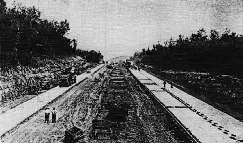
This 1953 photo shows paving work underway on the New York State Thruway mainline near Kingston. (Photo by New York State Thruway Authority.)
MAINTAINING THE THRUWAY: Like most toll road authorities, the NYSTA receives no appropriations of tax money from the Legislature to meet the cost of any of its operations. The Thruway Authority sold $972 million in bonds to pay for the construction costs of the Thruway's toll sections, $600 million for the original mainline and the remainder for the extensions. A total $500 million of these bonds is backed by full faith and credit of the New York State. The U.S. Bureau of Public Roads (BPR) has allocated federal aid to the New York State to help meet the costs of the free Thruway sections in Westchester, Rockland and Erie counties. Funds borrowed from the investors met the remainder of these costs.
The NYSTA's revenues pay all operating and maintenance expenses for both the toll and toll-free sections, including the full cost of the State Police. The Authority's revenues also pay for all bond retirement costs, including interest. Furthermore, thruway concessions - there are 27 service areas on the thruway mainline providing automobile service, restaurants, tourism information, ATM's and faxes - contribute to the NYSTA budget.
Specially trained crews maintain the thruway throughout the year at an annual cost of over $75 million. Maintenance crews are divided into four divisions (New York, Albany, Syracuse and Buffalo). These divisions are further divided into sections, each of which maintains an average of 28 miles of roadway.
More than 1,600 maintenance personnel use 3,000 different pieces of equipment to take care of the 559-mile Thruway system, including 819 bridges on the system. These include seven-ton trucks, pavement sweepers, mowing tractors and tugboats. Of some 1,400 vehicles in use, more than 400 can be converted into snowplows in winter. During the winter, special shifts are assigned to control snow and ice around the clock. During the summer, major improvements are carried out on the pavement, bridges, safety features and landscaping.
In August 1993, the NYSTA became the first agency to implement the EZ-Pass electronic toll collection system. Each year, the Thruway Authority processes more than 238 million toll transactions. Of these, about 84 million transactions - more than 230,000 per day - are EZ-Pass transactions. All of the more than 400 Thruway toll lanes accept EZ-Pass.
On July 1, 1995, the maximum speed limit on the mainline New York State Thruway was raised from 55 MPH to 65 MPH north of EXIT 16 (I-86, US 6 and NY 17) in Harriman. In 2001, the 65 MPH speed limit was extended south to the Rockland-Orange county line in Sloatsburg.
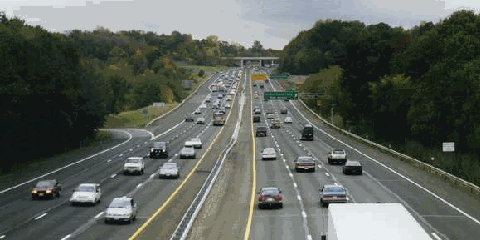
This 1999 photo shows the New York State Thruway (I-87), looking south at EXIT 4 (Cross County Parkway) in Yonkers. (Photo by Steve Anderson.)
THE THRUWAY IN WESTCHESTER AND ROCKLAND COUNTIES: The same year that the New York State Legislature authorized construction of the New York State Thruway, Hugh R. Pomeroy, chief planner of Westchester County, proposed three north-south "thruways" to supplement the existing parkways in the county. Unlike the parkways constructed by Robert Moses and his contemporaries in the 1920's and 1930's, these "thruways" were to be open to all traffic.
The "Hudson" (later New York State) Thruway was to parallel the Saw Mill River Parkway in the western corridor, while the "New England" Thruway was to parallel the Hutchinson River Parkway in the eastern corridor. A third "thruway" - the White Plains-Bronx Expressway - was to be in the central corridor already served by the Bronx River Parkway. By 1961, this "third thruway" proposal had been all but abandoned.
From Pomeroy's "Let's Be Realistic About Thruways:"
There is much uncertainty and some misinformation as to what sort of thoroughfares are proposed to take care of the major lines of traffic flow out of New York City. They are of two kinds: parkways and thruways. Since we all know what a parkway is, the simplest way of describing a thruway is to say that it is a high-standard parkway that is open to all traffic. In other words, a parkway is limited to non-commercial passenger vehicles, while a thruway is not. According to the acceptable standards of today, both parkways and thruways will be insulated by marginal landscaping, with no private frontage, will have divided roadways, and will have grade separation for all cross-movements of traffic.
Construction of the New York State Thruway in Westchester began in 1950. The Thruway was to begin at the New York City line, where it connects to the Major Deegan Expressway. In the city of Yonkers, the Thruway follows the route of Central Park Avenue from the city line to just north of EXIT 5 (NY 100). Between Yonkers and Elmsford, two routings were proposed. The first, which was proposed by Robert Moses, would have utilized the rights-of-way of the then-unbuilt Sprain Brook Parkway. The second, which was proposed by Westchester County and eventually adopted by the New York State Thruway Authority, paralleled Saw Mill River Parkway and Saw Mill River Road (NY 9A) via Central Park Avenue. In Elmsford, the New York State Thruway was planned to turn west at the junction of the Cross Westchester Expressway (EXIT 8, I-287) before the "Cross-Hudson" (Tappan Zee) Bridge.
A basic engineering feature of the Central Park Avenue route through Yonkers entailed construction of the Thruway at elevated or depressed levels, with flanking local service roads at ground level and occasional bridges to carry local traffic over the Thruway. In this area, the six lanes of Thruway, four lanes of service roads, breakdown shoulders and parking lanes occupy a 250-foot to 300-foot-wide right-of-way. Because of the numerous exits in this area, the New York State Legislature stipulated that the Thruway be toll-free as far north as EXIT 6 (Tuckahoe Road). North of Yonkers, the Thruway resembles a six-lane parkway with a 20-foot-wide center divider.
The 30 miles of New York State Thruway mainline through Rockland and Westchester counties was completed in August 1956. Two years later, the section between the New York City line and Elmsford (EXIT 8) received the I-87 designation, and the section from Elmsford west to Suffern received the I-287 designation. It was not until 1970, when the section of the Thruway between EXIT 8 and EXIT 17 became eligible for Interstate status, that the designation for I-87 was shifted from eastern Westchester County to the mainline, making the entire mainline Interstate 87 from New York City to Albany.
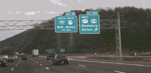
During the 1990's, the NYSTA constructed new interchanges along the Thruway. In Suffern, the new EXIT 15, a "directional-T" interchange built for the just-completed I-287 beltway in New Jersey, opened in mid-1994, replacing an old "trumpet" interchange. Nearby, a new interchange - EXIT 15A - was constructed for local traffic using NY 17 and NY 59. In West Nyack, reconfigured ramps and a new bridge were constructed at EXIT 12 (NY 303) to permit access to the new Palisades Center shopping mall. Across the Hudson in Yonkers, a new interchange - EXIT 6A (Stew Leonard Drive) - was constructed for a nearby industrial park and shopping center.
In 1998, the Westchester County Executive introduced legislation to remove the Yonkers barrier toll plaza, but the legislation was never enacted. Earlier in the 1990's, the Suffern barrier toll plaza was removed, and tolls for passenger cars at the Spring Valley barrier toll plaza were eliminated. Tolls still apply for commercial vehicles at the Spring Valley plaza.
According to the New York State Department of Transportation (NYSDOT), the New York State Thruway carries approximately 75,000 vehicles per day (AADT) through Westchester County, a volume that rises to 90,000 vehicles per day through Rockland County.
IMPROVEMENTS IN THE LOWER HUDSON VALLEY: In 2001, the NYSTA started a three-year, $187 million project to reconstruct the New York State Thruway between the Tappan Zee Bridge toll plaza in Tarrytown and EXIT 8 (I-287 / Cross Westchester Expressway) in Elmsford. The project, which continued along the Cross Westchester Expressway east to EXIT 1 (Saw Mill River Parkway and NY 119) and was completed in May 2004, is described as follows:
Reconfigured EXIT 8 to provide straight-through direct connector roadways three lanes wide in each direction to and from the New York State Thruway and the Cross Westchester Expressway. To distribute traffic more efficiently from the Tappan Zee Bridge, there now is a three-lane, left-hand exit from I-87 southbound to I-287 eastbound. Two lanes of I-87 now continue southbound from EXIT 8. In addition, there is a new southbound EXIT 8A on the Thruway for NY 119 and the northbound Saw Mill River Parkway.
Built new ramps and collector-distributor (C/D) roadways in each direction along the Cross Westchester Expressway from the Thruway terminus east to EXIT 1 (NY 119-Tarrytown Road and Saw Mill River Parkway).
Built new bridges over the New York State Thruway, Cross Westchester Expressway and connecting roadways.
Added new two 35 MPH EZ-Pass lanes at the eastbound / southbound Tappan Zee Bridge toll plaza.
The NYSTA also approved $114 million in projects to rebuild 15 bridges in Westchester and Rockland counties, and to repave the main roadways through Rockland County.
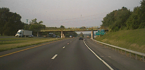
This 1998 photo shows the New York State Thruway (I-87 and I-287) from the NY 59 overpass in Spring Valley, looking north (west) toward EXIT 14A (Garden State Parkway Extension). (Photo by Steve Anderson.)
THE THRUWAY IN THE MID-HUDSON VALLEY: Through Orange County, the New York State Thruway carries approximately 80,000 vehicles per day (AADT) from EXIT 15 (I-287 and NJ 17) north to EXIT 16 (I-86 / US 6 / NY 17), dropping to 40,000 vehicles per day north of the Harriman interchange.
In 2002, the Federal Highway Administration (FHWA) gave formal approval to previously announced plans to build a $100 million direct interchange connection from I-87 (EXIT 17) to I-84 in Newburgh. At the present time, approximately 35,000 vehicles per day (AADT) use NY 300 (Union Avenue) to travel between the two interstate highways. Under the proposal, access to NY 300 from I-84 will remain at the existing EXIT 7N location, with modified ramps and new intersections to be constructed at the ramp terminals. Access to NY 300 from the Thruway (EXIT 17) will be from new ramps that will meet NY 300 at the intersection across from the I-84 eastbound ramp (EXIT 7N). The existing ramp system to access NY 300 will be removed, while the existing ramps adjacent to the Thruway will remain. Work on the project began in August 2003 and is scheduled for completion in May 2009.
This 2000 photo shows the southbound New York State Thruway (I-87) at EXIT 15A (NY 17 and NY 59) in Sloatsburg, Rockland County. (Photo by Douglas Kerr.)
TRAGEDY ON THE THRUWAY: On October 9, 1997, a section of the New York State Thruway was closed at EXIT 5 (NY 100) when a gasoline truck exploded underneath a thruway overpass, killing a motorist and destroying the overpass. Eleven days later, two temporary bridges, each carrying two lanes of northbound and southbound traffic, were installed at the location. This allowed traffic to move through the area while work crews constructed a permanent overpass.
Less than five months after the accident, a new seven-lane bridge carrying the thruway over Central Park Avenue was completed at a cost of $2.4 million. The work involved reconstruction of bridge abutments, erection of Inverset units - part of a process that involves the upside-down placement of a reinforced concrete bridge deck on a prefabricated steel frame - on site, and final preparation of the site.
This was not the first time that a structural failure on the New York State Thruway took the lives of motorists. On the morning of April 5, 1987, a 330-foot section of the 540-foot-long bridge spanning Schoharie Creek near Amsterdam collapsed, taking the lives of ten motorists. The collapse, which involved a steel-plate girder bridge covered with steel-reinforced concrete, took over several stages over a span of ninety minutes. Inundated with two days' worth of torrential rains, the fast-moving Schoarie Creek, which was now 30 feet deep instead of the usual ten-foot depth, ravaged the bridge pilings. The bridge, which was built in 1956, was rehabilitated in 1982 and passed inspection in 1986.
The I-90 Thruway mainline bridge over Schoharie Creek reopened after a year of reconstruction and detours on US 20 and NY 5S.
GOING PRIVATE? In January 2005, just one day after New Jersey acting Governor Richard Codey proposed either selling or leasing rights the state's toll roads to private investors, NYSDOT Commissioner Joseph Boardman hinted at selling the Thruway, or parts of the Thruway such as the Tappan Zee Bridge, to private investors. Governor George Pataki did not comment on this plan. Toll hikes implemented in May 2005 and January 2008 went toward $2 billion in improvement projects.
This 2001 photo shows the New York State Thruway (I-87) at the Sawkill Road overpass in Kingston. (Photo by C.C. Slater.)
The speed limit on the New York State Thruway should be raised to 60 MPH from EXIT 5 (NY 100) in Yonkers north to EXIT 15A (NY 17 and NY 59) in Suffern. The exception to this new speed limit would be across the Tappan Zee Bridge.
EIGHT LANES ALONG THE I-287 CORRIDOR: To accommodate current and future demand on the I-287 corridor, a minimum of eight lanes should be provided along the Thruway from EXIT 8 (I-287 / Cross Westchester Expressway) in Elmsford to EXIT 15 (I-287 and NJ 17) in Suffern.
SIX LANES TO ALBANY: To accommodate future increases in traffic demand through the Hudson Valley, the Thruway should be widened from four to six lanes from EXIT 16 (I-86 / NY 17 / Quickway) in Harriman north to EXIT 24 (I-87 / Adirondack Northway and I-90 / Northside Arterial) in Albany.
SOURCES: Highway Needs in New York State, New York State Department of Public Works (1949); "Let's Be Realistic About Thruways" by Hugh R. Pomeroy, Westchester County Planning Department (2/21/1950); "O'Dwyer Endorses Plans on Thruway" by Douglas Dales, The New York Times (3/07/1950); "Statement on Navigation Aspects of the Proposed Nyack-Tarrytown Location for the New York State Thruway Crossing of the Hudson River" by Hugh R. Pomeroy, Westchester County Planning Department (1/04/1951); "Route in Yonkers Set for Thruway," The New York Times (3/09/1951); "Estimated Traffic, Revenue and Expenses on the New York State Thruway," New York State Thruway Authority (1951); "Thruway Jumps the Hudson River to Yonkers" by Joseph C. Ingraham, The New York Times (12/04/1955); "Thruway Through" by Joseph C. Ingraham, The New York Times (8/26/1956); "Splicing the Toll Road Network," The New York Times (8/26/1956); "Yonkers Rushing Last Thruway Tie" by Merrill Folsom, The New York Times (8/27/1956); "Bridge Collapses on the Thruway, Trapping Vehicles" by Robert O. Boorstin, The New York Times (4/06/1987); "Bridge Was Repaired 5 Years Ago and Passed an Inspection in 1986" by David W. Dunlap, The New York Times (4/06/1987); "Missing Link of Interstate Opens, Despite Lawsuit," The New York Times (11/20/1993); "One Dead in Fiery Collision of Tanker and Car" by Jane Gross, The New York Times (10/10/1997); Divided Highways by Tom Lewis, Viking-Penguin Books (1997); "Governor Announces I-84 / I-87 Direct Connection in Orange County," New York State Thruway Authority (5/05/1999); "Thruway Tolls Could Rise Every Year" by James M. Odato, The Albany Times-Union (1/29/2000); "Thruway Announces Start of Reconstruction of I-287 / I-87 Interchange," New York State Thruway Authority (2/27/2001); "Tappan Zee Bridge / I-287 Informational Open House," New York State Thruway Authority (2001); "I-84, Thruway Connector Gets Federal Funding" by John Milgram, The Times-Herald Record (3/02/2002); "New Lane Opens on 287" by Caren Halbfinger, The Journal-News (5/29/2004); "Want a Bridge? State Has Plenty" by Cathy Woodruff, The Albany Times-Union (1/26/2005); Jason Bullett; Phil Case; Rich Dean; Daniel T. Dey; David J. Greenberger; Ralph Herman; Jay Hogan; Michael G. Koerner; Nathan W. Perry; Jeff Saltzman; Stephen Summers; William Welner; Douglas A. Willinger.
I-87, I-287, I-90 and New York State Thruway shields by Ralph Herman. Lightposts by Millerbernd Manufacturing Company. Speed limit sign by C.C. Slater.