
|
|
||
|
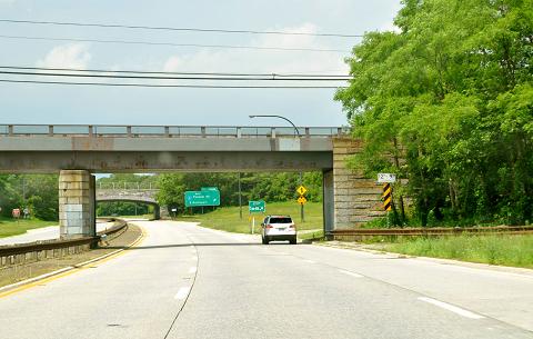
This 2015 photo shows the northbound Sunken Meadow State Parkway approaching EXIT SM4 (Suffolk CR 11 / Pulaski Road) in Kings Park. In the foreground is the overpass for the LIRR Port Jefferson Branch. (Photo by Dave Watts.) |
||
|
Length: |
||
|
6.2 miles (10.0 kilometers) |
||
|
Passenger cars only south of EXIT SM5 (NY 25A / Fort Salonga Road). |
||

|
A NEW PARKWAY TO THE NORTH SHORE: In the late 1920s, Robert Moses, who served as state parks commissioner under Governor Alfred E. Smith, acquired several parcels of land totaling more than 500 acres from George and Antoinette Lamb. The shorefront property, which straddled the Fort Salonga-Kings Park border, opened as Sunken Meadow State Park in 1929. |
||
|
The first roadway construction along the route of the Sunken Meadow State Parkway dates to 1929, when a new two-lane causeway and three-lane bridge from NY 25A in Kings Park to the new state park. Moses drafted plans a four-lane, limited-access parkway - called the "Sunken Meadow Spur" - to connect the park with the Northern State Parkway. |
||
|
In 1978, a new exit, EXIT SM3-A (Suffolk CR 14 / Indian Head Road) in Commack, opened to provide better access to Indian Head Road. Prior to this improvement, northbound motorists on the Sunken Meadow Parkway had to get off at EXIT SM3-E (NY 25 East) before turning left immediately from the end of the off-ramp. |
||
|
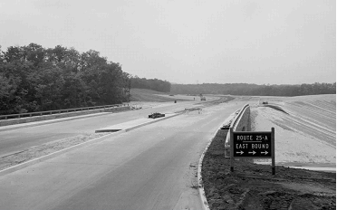
This 1957 photo shows the Sunken Meadow State Parkway nearing completion. The photo was taken looking south at EXIT SM5 (NY 25A). (Photo from Kings Park Heritage Museum, www.kpheritagemuseum.net.) |
||
|
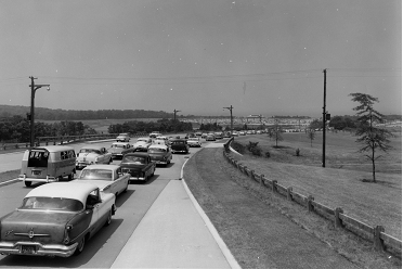
This 1957 photo shows the Sunken Meadow State Parkway soon after its completion. The photo was taken looking north approaching Sunken Meadow State Park. (Photo from Kings Park Heritage Museum, www.kpheritagemuseum.net.) |
||

|
WHAT'S BEING PLANNED: According to the NYSDOT, the Sunken Meadow State Parkway handles approximately 70,000 vehicles per day from the Northern State Parkway north to EXIT SM3 (NY 25 / Jericho Turnpike), and approximately 25,000 vehicles per day north of Jericho Turnpike. |
||
|
The NYSDOT and the New York Metropolitan Transportation Council (NYMTC) have developed the following long-range projects for the parkway: |
||
|
|
||

|
ONCE CONSIDERED FOR SOUND BRIDGE APPROACH: In 2017, Governor Andrew Cuomo commissioned a new study for a fixed crossing of Long Island Sound. One proposal featured a bridge, tunnel, or hybrid option connecting the Sunken Meadow-Sagtikos State Parkway corridor north from Kings Park to Westport, Connecticut via the Sherwood Island Connector. The proposal was opposed by local officials who feared Sunken Meadow State Park would be affected negatively, as the proposed approach highway would cut the park in half. Officials also opposed the proposed reconstruction of the Sunken Meadow and Sagtikos State Parkways that would have been required for the southern approach route. |
||
|
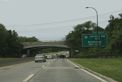
This 2004 photo shows the northbound Sunken Meadow State Parkway at EXIT SM3 (NY 25 / Jericho Turnpike) in Commack. (Photo by Steve Anderson.) |
||

|
SIX LANES SOUTH OF ROUTE 25: The Sunken Meadow State Parkway should be widened to six lanes from EXIT SM1 (Northern State Parkway) north to EXIT SM3 (NY 25 / Jericho Turnpike), as per the recommendations of the Long Island Regional Planning Board and the NYSDOT's 2017 operational study. In conjunction with this project, the Sagtikos State Parkway should be widened to six lanes for its entire length, with ramps improvements suggested in the 2017 study This may provide the best opportunity to improve north-south traffic flow in western Suffolk County. |
||

|
SOURCES: "LI Parkway Link Will Open Today," The New York Times (4/01/1957); The Power Broker by Robert A. Caro, Vintage Books-Random House (1974); History of the Long Island State Parkway System, New York State Department of Transportation (1985); Robert Moses: Single-Minded Genius by Joann P. Krieg, Heart of the Lakes Publishing (1989); "LI's Roads in a Big Jam" by Tom Morris, Newsday (2/22/1990); "A Drive for New, Wider Roads" by Mara Rose, Newsday (2/22/1990); "Sagtikos / Sunken Meadow State Parkway Operational Study," New York State Department of Transportation (2017); "Critics Say Long Island Sound Crossing Would 'Destroy' State Park" by Nicholas Spangler, Newsday (1/21/2018); "Cuomo Administration Drops Idea for Bridge-Tunnel Crossing LI Sound" by Yancey Roy, Newsday (6/29/2018); New York Metropolitan Transportation Council; S. Berliner, III; Cynthia Blair; Daniel T. Dey; Bill Frohlich; Ralph Herman; Nathan W. Perry; Jim Wade. |
||

|
SUNKEN MEADOW STATE PARKWAY LINKS: |
||

|
SUNKEN MEADOW STATE PARKWAY NYSDOT CONTRACT ARCHIVES: |
||
|
SUNKEN MEADOW STATE PARKWAY CURRENT TRAFFIC CONDITIONS: |
||
|
SUNKEN MEADOW STATE PARKWAY VIDEO LINK: |
||

|
THE EXITS OF METRO NEW YORK: |
||

|
Back to The Roads of Metro New York home page. |
||
|
Site contents © by Eastern Roads. This is not an official site run by a government agency. Recommendations provided on this site are strictly those of the author and contributors, not of any government or corporate entity. |
||