
|
|
||
|
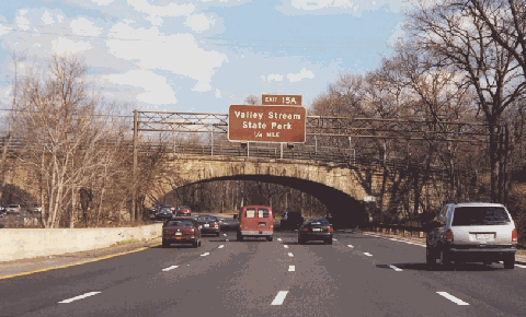
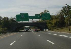
This 2000 photo shows the Southern State Parkway approaching EXIT 15A (Valley Stream State Park). The original bridge crosses the eastbound lanes, while a new bridge built in the 1950s was added to cross the westbound lanes. (Photo by Steve Anderson.) |
||
|
Length: |
||
|
25.5 miles (41.1 kilometers) |
||
|
Passenger cars only. Height restrictions apply. |
||

|
EARLY PLANNING AND DEVELOPMENT: Robert Moses, the new commissioner of the Long Island State Park Commission (LISPC), envisioned a network of parkways to connect New York City with new and proposed state parks on Long Island. The parkways proposed by Moses were planned to be "ribbon parks" that would not only separate the roadway from neighboring communities, but also serve as an extension of the main parks. |
||
|
Soon after he assumed the LISPC post in 1924, Moses discovered an undeveloped strip of land that had been bought by the city of Brooklyn that ran all the way out to Suffolk County. Prior to the consolidation of New York City in 1898, Brooklyn imported its drinking water from the Island's aquifer and piped it along what is now Conduit Boulevard to a reservoir in Ridgewood. After merging with Manhattan, Brooklyn abandoned its Long Island wells but continued to maintain the right-of-way. This right-of-way was to be used for the proposed Southern State Parkway. |
||
|
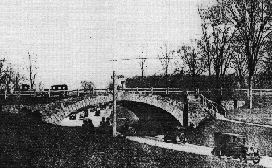
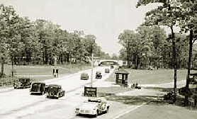
LEFT: This 1932 photo shows the original Southern State Parkway through Valley Stream. Note the lack of a median barrier in the four-lane roadway, as well as the pedestrian path alongside the roadway. RIGHT: This 1936 photo shows the Southern State Parkway at EXIT 22 (Meadowbrook State Parkway) in North Merrick. The interchange was expanded in the 1950's when the Meadowbrook State Parkway was extended north to the Northern State Parkway. (Photos by New York State Department of Parks, Recreation and Historic Preservation.) |
||

|
EXPANDING IN LENGTH AND WIDTH: In 1930, Nassau County provided extra land to the Long Island State Park Commission to widen the average right-of-way along the Southern State Parkway to 250 feet. By 1932, the Southern State Parkway reached the Nassau-Suffolk border, ending at EXIT 32 (NY 110) in North Amityville. This section continued the undivided four-lane roadway design. |
||
|
Continuing east into Suffolk County, the Southern State Parkway took on a more advanced design: two 25-foot-wide roadways, separated by a ten-foot-wide grassed median. The parkway extended to EXIT 33 (NY 109) in 1939, EXIT 38 (Belmont Lake State Park) in 1940, EXIT 39 (NY 231-Deer Park Avenue) in 1947, and reached its originally planned terminus at EXIT 41 (CR 57-Bay Shore Road) in 1949. In 1962, the Southern State Parkway was extended east of this location as the Heckscher (Spur) State Parkway. |
||
|
DESIGN CHANGES (1945-1963): As one of the pioneer limited-access highways in the United States, the Southern State Parkway received many changes and improvements over the years. Some of these were a result of improvements in highway design, while others were brought about by the changes in traffic patterns. The explosive postwar growth of the late 1940s and 1950s changed the purpose of the parkways: they were to serve the new residential, commercial and industrial areas of Nassau and Suffolk counties. To meet these new demands, the Southern State Parkway had to change. |
||
|
In 1947, the circuitous routing around Hempstead Lake (between EXIT 18 and EXIT 19) was abandoned, and was replaced by a more direct route constructed on earthen fill. This section was left abandoned - complete with the original timber lightposts - until 1957, when the eastern part of the perimeter route was taken over by the Nassau County Department of Public Works for an extension of Peninsula Boulevard (Nassau CR 2), and was modernized into a four-lane divided boulevard. |
||
|
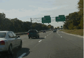
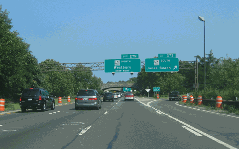
These 2001 photos show the westbound Southern State Parkway at EXIT 29 (NY 107) in North Massapequa (left photo) and at EXIT 24 (Merrick Avenue) in North Merrick. (Photos by Mike Tantillo.) |
||
|
DESIGN CHANGES (1977-PRESENT): In 1977, maintenance of the Southern State Parkway was transferred from the LISPC to the New York State Department of Transportation (NYSDOT), although ownership remained under the jurisdiction of the New York State Office of Parks, Recreation and Historic Preservation (NYSOPRHP). |
||
|
To accommodate the increase in traffic volume and speed, and to address the accident history, the NYSDOT began to modify the parkway in accordance with federal and state traffic safety guidelines. Such improvements made to increase operational safety included the installation of three-foot-high concrete ("Jersey") median barriers, steel guardrails and sand-filled impact attenuators. |
||
|
This 2007 photo shows the eastbound Southern State Parkway at EXIT 27 (Wantagh State Parkway) in Wantagh. (Photo by Steve Anderson.) |
||
|
ADDRESSING CURRENT AND FUTURE NEEDS: Despite the improvements, portions of the Southern State Parkway remain congested and dangerous. One section in Nassau County is nicknamed "Blood Alley" for its sharp curves, short acceleration and deceleration ramps, the profusion of smaller exits, and the close proximity of three intersecting north-south highways (the Meadowbrook State Parkway, the Wantagh State Parkway, and the Seaford-Oyster Bay Expressway). |
||
|
According to the NYSDOT, the Southern State Parkway handles approximately 190,000 vehicles per day (AADT) through Nassau County, dropping to approximately 130,000 vehicles per day through western Suffolk County. The NYSDOT and the New York Metropolitan Transportation Council have scheduled the following improvements on the parkway: |
||
|
|
||

|
ABOUT THE EXIT NUMBERING: Why does the exit numbering on the Southern State Parkway begin at EXIT 13 (Central Avenue)? Originally, the Southern State Parkway continued the exit numbering scheme of the Cross Island Parkway. The sequential numbering scheme began at EXIT 1 (Whitestone Parkway-Whitestone Bridge) and continued to EXIT 12 (Laurelton Parkway-Belt Parkway) before continuing along the Southern State Parkway. It was not until the late 1960s that the Cross Island Parkway adopted the numbering scheme of the Belt Parkway. |
||
|
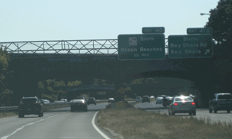
This 2014 photo shows the westbound Southern State Parkway at EXIT 41 (Suffolk CR 57 / Bay Shore Road) in West Islip. A westbound collector-distributor (C/D) road is used for EXIT 41 and EXIT 40 (Robert Moses Causeway). (Photo by Steve Anderson.) |
||

|
AN EXTENSION TO MONTAUK POINT: In 1936, the Regional Plan Association recommended the construction of an expressway and parkway network covering the entire New York metropolitan area. One proposal in this network called for the extension of the Southern State Parkway along the route of the Heckscher State Parkway east to Islip Terrace, then on new right-of-way east to Montauk Point. |
||
|
The proposed eastern extension of the Southern State Parkway was never officially mapped by the LISPC. However, it may have considered by the LISPC as a long-range proposal, since it would have connected to the William Floyd Parkway and (unbuilt) Ponquogue Causeway, as well as to Hither Hills and Montauk Point state parks. |
||

|
The Southern State Parkway and Heckscher State Parkway should be widened from six to eight lanes east to EXIT 44 (NY 27 / Sunrise Highway) in East Islip, in accordance with the "LITP 2000" plan. In conjunction with the widening project, interchange improvements should be made where appropriate, particularly at EXIT 22 (Meadowbrook State Parkway), EXIT 27 (Wantagh State Parkway) and EXITS 28 A-B (NY 135 / Seaford-Oyster Bay Expressway). Collector-distributor (C/D) roads also should be built where appropriate. |
||
|
Jim Wade, Long Island contributor to nycroads.com, suggested the following improvements be made to the Southern State Parkway: |
||

|
SOURCES: "Freeways Are Now Urged," The New York Times (12/13/1936); Arterial Progress 1959-1965, Triborough Bridge and Tunnel Authority (1965); Public Works: A Dangerous Trade by Robert Moses, McGraw-Hill (1970); The Power Broker by Robert A. Caro, Vintage Books-Random House (1974); History of the Long Island State Parkway System, New York State Department of Transportation (1985); Robert Moses: Single-Minded Genius by Joann P. Krieg, Heart of the Lakes Publishing (1989); "Road to Ruin: Southern State, LI's Oldest Highway, Has Become Its Worst" by Adam Z. Horvath, Newsday (9/03/1993); "Evolution of a Highway" by Bill Davis, Newsday (3/21/1998); "Transit Bill Paving Way for Overdue LI Projects" by Ellen Yan and Elaine S. Povich, Newsday (5/19/1998); "Getting in Last Coin Toss for the Road" by Daniel Goodrich, Newsday (10/24/1999); "Traffic Alert: Delays on Southern State Parkway," WCBS-TV (7/28/2008); New York Metropolitan Transportation Council; Dave Block; Russ Blau; Daniel T. Dey; Fred Hadley; Ralph Herman; Larry Lucchetti; Nathan W. Perry; Jim Wade. |
||
|
SOUTHERN STATE PARKWAY LINKS: |
||
|
SOUTHERN STATE PARKWAY CURRENT TRAFFIC MAPS: |
||
|
SOUTHERN STATE PARKWAY VIDEOS: |
||

|
THE EXITS OF METRO NEW YORK: |
||

|
Back to The Roads of Metro New York home page. |
||
|
Site contents © by Eastern Roads. This is not an official site run by a government agency. Recommendations provided on this site are strictly those of the author and contributors, not of any government or corporate entity. |
||