A NORTH SHORE "RIBBON PARK" TO THE OYSTER BAY-RYE BRIDGE: In 1965, Robert Moses officially announced plans for a Long Island Sound crossing that was to connect Oyster Bay in Nassau County with Rye in Westchester County. Although Moses had retired as chairman of the Long Island State Park Commission two years earlier, he proposed a new North Shore network of parks and parkways to connect into the Oyster Bay-Rye Bridge (proposed I-287 extension).
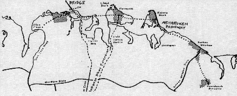
The Sound Shore Parkway, a little-known proposal that did not appear on public documents, was to have been a 22-mile-long parkway extending east along the Long Island Sound coastline from downtown Glen Cove to Sunken Meadow State Park in Kings Park. Like Moses' earlier parkways, the proposed route was to feature new state parks and "ribbon park" buffers. The four-lane parkway was to have been constructed as follows:
Beginning at NY 107 in downtown Glen Cove, the parkway was to extend northeast to a new state park in Lattingtown.
East of Lattingtown, the parkway would have continued east past Bayville (the site of the interchange with the Oyster Bay-Rye Bridge) and Centre Island to a causeway crossing of Cold Spring Harbor.
Moving into Suffolk County at Lloyd Harbor, the Sound Shore Parkway would have intersected the proposed Caumsett State Parkway at Caumsett State Park, then would have crossed on a second causeway (this time over Huntington Bay) into Eatons Neck. A new state park would have been developed at Eatons Neck.
At Eatons Neck, the parkway was to swing southeast toward Asharoken and Fort Salonga. Through the village of Asharoken, a narrow land strip connecting Eatons Neck to the rest of Long Island, the parkway would have been constructed on elevated fill along the sound-side beach.
The Sound Shore Parkway was to have its eastern terminus at Sunken Meadow State Park, where it was to connect with the existing Sunken Meadow State Parkway. A future extension of the Sound Shore Parkway southeast to Caleb Smith State Park in Smithtown may also have been considered.
By the early 1970's, fiscal and environmental concerns brought future highway plans on Long Island to a standstill. Ultimately, it was the efforts of a Lloyd Harbor-based group, Action for the Preservation and Conservation of the North Shore of Long Island, which thwarted plans for both the Sound Shore Parkway and the Oyster Bay-Rye Bridge.
Daniel Timothy Dey, frequent contributor to nycroads.com, responded to the Sound Shore Parkway discovery as follows:
Your recent addition of the Sound Shore Parkway reminds me of a notable feature in Sunken Meadow State Park, along the park road between parking lots #1 and #3: the streetlights. They look like they were to be used for an extra westbound lane that was going to be built there someday. Now I know the Long Island State Park Commission's ambitions went far beyond a park road with increased capacity.
Map of the proposed Sound Shore Parkway and connecting routes. (Map supplied by Ray Ingersoll, Asharoken News.)
SOURCES: "The Bridge That Almost Was" by Ray Ingersoll, Asharoken News (May-June 2000); Daniel T. Dey; Mark O' Rourke.
Sound Shore Parkway shield by Ralph Herman. Lightpost by Jeff Saltzman.