Bookmark and Share

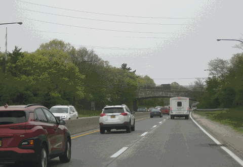
This 2019 photo shows the southbound Sagtikos State Parkway approaching the Campus Road (G Road) overpass in Brentwood. (Photo by Steve Anderson.)

Length:
Constructed:
NYSDOT Reference Route:

4.9 miles (7.9 kilometers)
1950-1952
NY 908K

Passenger cars only. Height restrictions apply.

CLOSING THE PARKWAY LOOP: Situated between the Northern State Parkway and the Southern State Parkway, the Sagtikos State Parkway closed the gap existing between their easterly ends. The completion of the Sagtikos State Parkway in September 1952 created a closed, connected parkway system. The project, which had spent two decades in the planning stages, took just over two years to construct at a cost of $8 million.

The Sagtikos State Parkway was constructed of two 24-foot-wide roadways, carrying two lanes in each direction, each separated by a nine-foot-wide grassed median. Mountable three-inch-high curbs were to allow disabled motorists to move off the parkway onto the shoulders. All crossroads and the Long Island Rail Road mainline branch were grade separated. Between EXIT S3 (Pine Aire Drive) and EXIT S4 (Southern State Parkway), the Sagtikos State Parkway was built on the right-of-way for the former Sagtikos Manor Lane, which led to the Gardiner Estate and Sagtikos Manor (now Gardiner County Park).

Together, the Sunken Meadow-Sagtikos-Robert Moses corridor forms the only north-south, fully controlled-access highway in Suffolk County. North of the Northern State Parkway, the Sagtikos State Parkway continues as the Sunken Meadow State Parkway. South of the Southern State Parkway, the Sagtikos State Parkway continues as the Robert Moses Causeway.

DESIGN CHANGES: In 1977, maintenance of the Sagtikos State Parkway was transferred from the Long Island State Park Commission (LISPC) to the New York State Department of Transportation (NYSDOT), although ownership remained under the jurisdiction of the New York State Office of Parks, Recreation and Historic Preservation (NYSOPRHP). To accommodate the increase in traffic volume and speed, and to address the accident history, the NYSDOT began to modify the parkway in accordance with federal and state traffic safety guidelines.

During the late 1980s and early 1990s, new MUTCD-compliant signs and high-intensity lighting were installed along the length of the parkway. A new concrete ("Jersey") barrier was installed down the center median (replacing a timber-post guardrail), and sand-filled impact attenuators were placed at overpasses.

In the mid-1990s, the NYSDOT reconstructed the interchange between the parkway and the Long Island Expressway (I-495). This interchange, originally completed in 1963 when the expressway was being built through western Suffolk County, was rebuilt with new "fly-over" ramps and service roads. There are provisions on the parkway overpasses over the LIE for an additional lane in each direction.

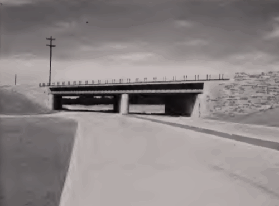
These photos show the Crooked Hill Road (Suffolk CR 13) overpass over the Sagtikos State Parkway under construction in 1951 (left photo) and completed in 1952 (right photo.) (Photos from the Long Island State Park Commission archives.)

CURRENT AND FUTURE IMPROVEMENTS: According the NYSDOT, the Sagtikos State Parkway handles approximately 80,000 vehicles per day (AADT). The NYSDOT and the New York Metropolitan Transportation Council have scheduled the following short- and long-range improvements for the parkway:

  • The NYSDOT allocated $3.5 million for a design study on the Sagtikos State and Sunken Meadow State parkways. The study, which examined possible safety and operational improvements along the 10.9 miles from the Southern State Parkway north to Sunken Meadow State Park, was completed in late 2005. A follow-up study completed in 2017 examined more specific improvements such as widening the Sagtikos-Sunken Meadow corridor to six lanes from the Southern State Parkway north to NY 25 (Jericho Turnpike), as well as ramp improvements.

  • Longer-range plans call for the creation of two new travel lanes to be set aside for HOV use during rush-hour periods. These lanes are expected to handle the new "Long Island Rapid Commute" (LIRC) vehicles envisioned by the "LITP 2000" plan. According to the NYSDOT, the LIRC articulated vehicles would travel on dedicated new and existing HOV lanes on controlled-access highways, as well as on existing arterial roads.

WILL TRUCKS COME TO THE SAGTIKOS PARKWAY? In 2004, the NYSDOT and the Long Island Rail Road (LIRR) unveiled plans for an intermodal facility on state property once occupied by the Pilgrim State Hospital campus just north of the Heartland industrial park. Using an existing LIRR spur (which would be refurbished) and the existing right-of-way, freight would be delivered by train to the site before being transferred to trucks for local delivery.

The following options are being considered for trucks traveling to and from the intermodal site:

  • ALTERNATIVE 1: Rebuilding the existing Sagtikos State Parkway to accommodate trucks from the Long Island Expressway (I-495) south to a new interchange (EXIT S2A). In this alternative, at least one additional lane in each direction would need to be built to accommodate trucks, and new bridges would need to be built.

  • ALTERNATIVE 2: Same as alternative 1, but parallel roadways would need to be built to accommodate trucks. New bridges would need to be rebuilt, and additional right-of-way may need to be acquired.

  • ALTERNATIVE 3: Trucks would utilize existing local roads such as Commack Road (Suffolk CR 4), Wicks Road (Suffolk CR 7), Crooked Hill Road (Suffolk CR 13), and Campus Road (Suffolk CR 106).

The intermodal site is in the design and environmental study stage. No timeline has been set for its construction.

ONCE CONSIDERED FOR SOUND BRIDGE APPROACH: In 2017, Governor Andrew Cuomo commissioned a new study for a fixed crossing of Long Island Sound. One proposal featured a bridge, tunnel, or hybrid option connecting the Sunken Meadow-Sagtikos State Parkway corridor north from Kings Park to Westport, Connecticut via the Sherwood Island Connector. The proposal was opposed by local officials who feared Sunken Meadow State Park would be affected negatively, as the proposed approach highway would cut the park in half. Officials also opposed the proposed reconstruction of the Sunken Meadow and Sagtikos State Parkways that would have been required for the southern approach route.

REMEMBERING THE GARDINERS: The underpass carrying the northbound Sagtikos State Parkway underneath the westbound Southern State Parkway bears the following plaque from the LISPC, which built the underpass during the early 1960s:

"In memory of David Gardiner, from Sarah Diodati Gardiner and Robert David Lion Gardiner."

The Gardiners were the first non-native landowners in Suffolk County. In 1639, Lion Gardiner purchased Gardiner's Island (off the coast of East Hampton) from Native Americans, and founded the first English colony in present-day New York (it was part of Connecticut at the time). In 1758, the Gardiner family purchased a 1,200-acre estate in Bay Shore from Stephanus Van Cortlandt, the first native-born mayor of New York City. The estate had a manor house (built in 1692) called "Sagtikos Manor," which was named after a local Indian word meaning "snake that hisses."

The Gardiners disposed of much of the land before the Sagtikos State Parkway was planned, and sold Sagtikos Manor to Suffolk County in 1971. The last heir to bear the name of the Gardiners (and the "16th Lord of the Manor"), Robert David Lion Gardiner, died in 2004 at the age of 93.

This 2004 photo shows the Sagtikos State Parkway southbound about one mile north of EXIT S3 (Pine Aire Drive) in Brentwood. (Photo by Steve Anderson.)

SIX LANES ON THE SAGTIKOS: The Sagtikos State Parkway should be widened from four to six lanes along the entire length, as per the recommendations of the Long Island Regional Planning Board and the NYSDOT's 2017 operational study. In conjunction with this project, the Sunken Meadow State Parkway should be widened to six lanes from EXIT SM1 (Northern State Parkway) north to EXIT SM3 (NY 25 / Jericho Turnpike), while ramps improvements suggested in the 2017 study should be considered on both parkways.  This may provide the best opportunity to improve north-south traffic flow in western Suffolk County.

SOURCES: "Sagtikos Parkway Link to Open," The New York Times (9/25/1952); "Completion of the Northern State Parkway and the Sagtikos State Parkway," Long Island State Park Commission and New York State Department of Public Works (1952); The Power Broker by Robert A. Caro, Vintage Books-Random House (1974); History of the Long Island State Parkway System, New York State Department of Transportation (1985); Robert Moses: Single-Minded Genius by Joann P. Krieg, Heart of the Lakes Publishing (1989); "LI's Roads in a Big Jam" by Tom Morris, Newsday (2/22/1990); "A Drive for New, Wider Roads" by Mara Rose, Newsday (2/22/1990); "Freight Movement Issues in the Region: First Steps Toward Implementing Solutions," New York Metropolitan Transportation Council (1998); "LI Attempting To Get on Track" by Joie Tyrrell, Newsday (6/27/2004); "Robert Gardiner, Lord of His Own Island, Dead at 93" by Robert F. Worth, Newsday (8/30/2004); "Sagtikos / Sunken Meadow State Parkway Operational Study," New York State Department of Transportation (2017); "Cuomo Administration Drops Idea for Bridge-Tunnel Crossing LI Sound" by Yancey Roy, Newsday (6/29/2018); Tri-State Transportation Campaign; Daniel T. Dey; Ralph Herman; Ned Merrill; Nathan W. Perry; Jim Wade.

  • Sagtikos State Parkway shield by Ralph Herman.
  • Lightpost by Jeff Saltzman.
  • HOV sign by C.C. Slater.

SAGTIKOS STATE PARKWAY LINKS:

SAGTIKOS STATE PARKWAY CURRENT TRAFFIC CONDITIONS:

SAGTIKOS STATE PARKWAY VIDEO LINK:

THE EXITS OF METRO NEW YORK:

  • Sagtikos State Parkway exit list by Steve Anderson.

Back to The Roads of Metro New York home page.

Site contents © by Eastern Roads. This is not an official site run by a government agency. Recommendations provided on this site are strictly those of the author and contributors, not of any government or corporate entity.