
|
|
||
|
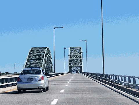
This 2018 photo shows the twin-span Robert Moses Causeway bridge heading south over Great South Bay. The two-lane southbound span opened in 1954 and was rebuilt in the late 1990s. The three-lane northbound span to the left opened in 1968. (Photo by Steve Anderson.) |
||
|
Length: |
||
|
8.1 miles (13.1 kilometers) |
||
|
Passenger cars only north of EXIT RM1 (NY 27 / Sunrise Highway). |
||

|
THE CAPTREE PARKWAY AND CAUSEWAY: The Robert Moses Causeway, which was known as the Captree State Parkway until 1963, forms part of the north-south parkway corridor from Sunken Meadow State Park in Kings Park to Robert Moses State Park at the western tip of Fire Island. |
||
|
Opposition to the "Captree Causeway" appeared soon after it was first proposed by Long Island State Parks commissioner Robert Moses in 1930. At that time, The Bay Shore Sentinel-Journal ran an advertisement from a South Shore citizens' group (led by mustard magnate Frank Gulden) opposing the causeway over Great South Bay as follows: |
||
|
The first causeway bridge, which had one northbound and one southbound lane, was opened to traffic in April 1954. The two-mile long span across Great South Bay to Captree Island features a 600-foot-long main span, with a 60-foot clearance for boats. On either side of the main steel-arch span, a series of piles support the roadway 25 feet above Great South Bay. The piles are arranged not only vertically, but also diagonally. The diagonal piles, which are called "batter piles," resist the forces along the roadway such as those caused by vehicles stopping or starting, as well as those caused by the expansion and contraction of the bridge deck due to temperature changes. |
||
|
At the southern terminus of the Great South Bay span, the Robert Moses Causeway continues south through Captree Island, where an interchange is provided for local traffic. After crossing the State Boat Channel over a 665-foot-long bascule bridge, the causeway meets the Ocean Parkway at a cloverleaf interchange. This interchange, which provides access to Captree State Park, Gilgo State Park, and Jones Beach State Park, served as the southern terminus of the Robert Moses Causeway until 1964. |
||
|
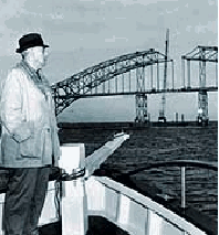
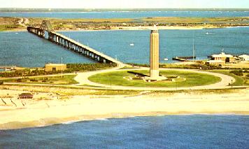
LEFT: Robert Moses observing construction of the single-span causeway bridge that bears his name over Fire Island Inlet, just before the bridge's completion in 1964. (Photo by New York State Division of Parks, Recreation and Historic Preservation.) RIGHT: The completed two-lane causeway leading to the water tower at Robert Moses State Park on Fire Island. (Postcard supplied by John Delin and Pamela Boslet Buskin.) |
||
|
ADDING CAPACITY ACROSS GREAT SOUTH BAY: The popularity of Robert Moses, Captree and Gilgo state parks seriously tested the traffic capacity of the original two-lane bridge and roadway. Southbound traffic to the beaches was backed up for miles in the morning, while northbound traffic to Long Island was heaviest in the late afternoon hours. To meet this demand, a parallel causeway was constructed over Great South Bay just east of the existing two-lane causeway. |
||
|
To accommodate the peak travel hours of the beach-going public who tend to arrive over several hours of the morning, but depart in a noticeably shorter period in the late afternoon, the new bridges and roadway for northbound traffic were constructed three lanes wide. Along Captree Island, the opposing roadways were separated by a wide, variable median. The original two-lane roadway became the southbound lanes of the causeway. The three-lane parallel Great South Bay span, which was to carry the northbound lanes, was constructed between 1966 and 1968. |
||
|
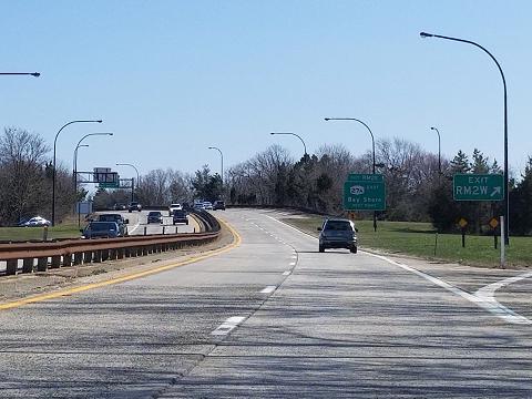
This 2018 photo shows the southbound Robert Moses Causeway at EXIT RM2 (NY 27A / Montauk Highway) in West Islip. (Photo by Steve Anderson.) |
||
|
ADDING CAPACITY ACROSS FIRE ISLAND INLET? While the opening of the parallel Great South Bay span alleviated some congestion, the Fire Island Inlet crossing continued to serve as a choke point. In its 1975 report Maintaining Mobility, the Tri-State Regional Planning Commission recommended studies on adding a parallel span over Fire Island Inlet: |
||
|
Increasing recreational activity on Fire Island will place heavy traffic on the two-lane bridge over Fire Island Inlet. Providing additional lanes, instituting traffic controls, introducing shuttle bus service, or implementing a combination of these options should be considered. |
||

|
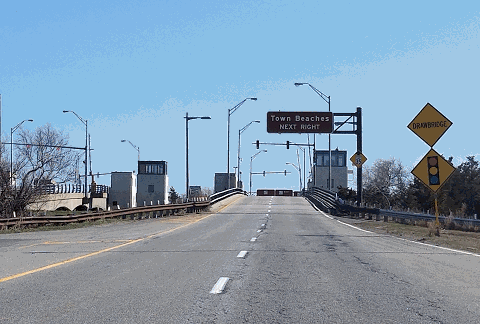
This 2018 photo shows the southbound Robert Moses Causeway at the Captree Inlet Drawbridge, which connects Captree Island with Jones Beach (Oak Beach) Island. (Photo by Steve Anderson.) |
||

|
SOURCES: "Restoration and Protection of Fire Island," Long Island State Park Commission (1938); "Captree Parkway and Span Opened," The New York Times (6/13/1954); Arterial Progress 1959-1965, Triborough Bridge and Tunnel Authority (1965); Public Works: A Dangerous Trade by Robert Moses, McGraw-Hill (1970); The Power Broker by Robert A. Caro, Vintage Books-Random House (1974); Maintaining Mobility, Tri-State Regional Planning Commission (1975); History of the Long Island State Parkway System, New York State Department of Transportation (1985); Robert Moses: Single-Minded Genius by Joann P. Krieg, Heart of the Lakes Publishing (1989); "Beach Causeway Closure Delayed" by Sylvia Adcock, Newsday (5/29/1997); "Ask Dr. Conehead" by Kim Nava, Newsday (4/05/1998); "Road Delays Ahead" by John Valenti, Newsday (5/26/2000); "DOT Announces Traffic Projects," Suffolk Life (5/30/2001); New York Metropolitan Transportation Council; Ralph Herman; Larry Lucchetti; Nathan W. Perry; Jim Wade; Russ Weisenbacher. |
||

|
ROBERT MOSES CAUSEWAY LINKS: |
||
|
ROBERT MOSES CAUSEWAY CURRENT TRAFFIC CONDITIONS: |
||
|
ROBERT MOSES CAUSEWAY VIDEO LINKS: |
||

|
ROBERT MOSES CAUSEWAY NYSDOT CONTRACT ARCHIVES: |
||

|
THE EXITS OF METRO NEW YORK: |
||

|
Back to The Roads of Metro New York home page. |
||
|
Site contents © by Eastern Roads. This is not an official site run by a government agency. Recommendations provided on this site are strictly those of the author and contributors, not of any government or corporate entity. |
||