
|
|
||
|
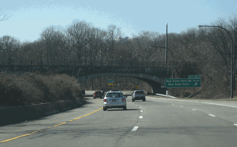
This 2016 photo shows the westbound Northern State Parkway at EXIT 26 (New Hyde Park Road) in North Hills. (Photo by Steve Anderson.) |
||
|
Length: |
||
|
28.9 miles (46.5 kilometers) |
||
|
Passenger cars only. Height restrictions apply. |
||

|
COMPETING WITH THE MOTOR PARKWAY: The Northern State Parkway and the Southern State Parkway were planned from the earliest days of the Long Island State Park Commission (LISPC) in 1925. As described in the 1927 LISPC report, "Main Highways and Parkways Provided and Proposed for Long Island" the Northern State Parkway was to be routed "through the highlands in Wheatly (Old Westbury), Manetto (Plainview), Half Hollow and Dix Hills in the northern part of the Island." The stated purpose for the parkway "was to make lands acquired in the suburbs (for parks) accessible to the whole metropolitan population." |
||
|
The parkway proposed by LISPC commissioner Robert Moses had the support of many in the business community, most notably banker and industrialist Horace Harding. Harding supported the Northern State Parkway plan, but wished to extend the scenic four-lane parkway east to Lake Ronkonkoma, roughly paralleling the route of the old Long Island Motor Parkway. Harding also urged the construction of a boulevard from Elmhurst to Manhasset, one that would later bear his name, to improve access to his Long Island country club. |
||
|
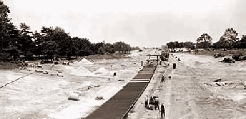
This 1937 photo shows workers constructing the Northern State Parkway through Nassau County. (Photo by New York State Division of Parks, Recreation and Historic Preservation.) |
||

|
PLANNING AND DEVELOPMENT IN NASSAU COUNTY: The wealthy property owners would ultimately influence the final route of the Northern State Parkway through Nassau County. In 1928, the same year that the New York State Legislature appropriated funds for the parkway, landowners in East Hills and Old Westbury established a lobbying fund to keep the parkway off their land. After months of acrimonious debate, Governor Alfred E. Smith reached an agreement with the landowners in December 1929. The result was that a two-mile detour, "Objectors' Bend," had to be inserted in the parkway to avoid a group of exclusive residences whose owners wanted the parkway kept as far away as possible. |
||
|
Construction of the Northern State Parkway began in July 1931 at a ceremony held at the Queens-Nassau border, jointly attended by Moses and Governor Franklin D. Roosevelt. The first section of parkway, which carried the route of the Grand Central Parkway eastward to EXIT 28 (Willis Avenue) in Roslyn, was completed in 1933. Its opening coincided with that of the initial section of the Grand Central Parkway, which extended west to Queens Boulevard in Kew Gardens. The route of the Northern State Parkway was extended around "Objectors' Bend" to EXIT 31 (Glen Cove Road) in Carle Place in 1934. |
||
|
Once the opposing landowners saw the landscaped results of the finished work, they were so impressed that some even complained that the additional two miles they had to travel to get on the parkway was a case of discrimination against them. Although the landowners in Old Westbury offered to contribute land for a two-mile long parkway spur to connect with the parkway, Moses refused their request. (However, this area would be bisected by a later Moses creation, the Long Island Expressway, in the late 1950s.) |
||
|
Between 1936 and 1938, the Northern State Parkway was extended to the Wantagh State Parkway (EXIT 33) in Westbury. This section was the beneficiary of changes in the parkway design of earlier years. From "Dictated by Safety" by Sidney M. Shapiro, assistant chief engineer of the LISPC, who published the following in 1938: |
||
|
YESTERDAY AND TODAY
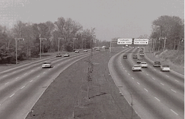
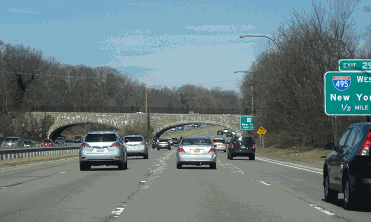
LEFT: This 1969 photo shows the Northern State Parkway looking west at EXIT 29A (I-495 / Long Island Expressway). Much of the parkway through western Nassau County was widened in the 1960s. (Photo supplied by Todd Berkun.) RIGHT: This 2016 photo shows the westbound Northern State Parkway at the I.U. Willets Road overpass in Roslyn Heights. (Photo by Steve Anderson.) |
||
|
EXTENDING INTO SUFFOLK COUNTY: The new Northern State Parkway design, which featured two 25-foot-wide, two-lane roadways separated by a variable median measuring as wide as 30 feet, was implemented through eastern Nassau County and western Suffolk County. Utilizing this design, the parkway was extended east to EXIT 40 (NY 110) in 1949, to EXIT 42 (NY 231, Suffolk CR 35 and Suffolk CR 66) in 1949, and to EXITS 44-45 (Sagtikos State Parkway and Sunken Meadow State Parkway) in 1952. The final segment of the Northern State Parkway east to the Veterans Memorial Highway (NY 347-NY 454) junction in Hauppauge, the last parkway segment built on Long Island, was completed in 1965. |
||
|
Unlike previous sections of the Northern State Parkway, which were designed with a single centerline for the alignment and profile of the roadway, the newer parkway section was designed with two individual roadways separated by a median varying in width from nine to more than fifty feet. The design speed was 75 MPH, which provided superior sight distance across horizontal and vertical curves at an operating speed of 50 MPH. Other design standards, such as 12-foot vertical clearances, wider shoulders, more generous curve and ramp radii, and longer acceleration and deceleration lanes, reflected the more contemporary design standards mandated for roads receiving Federal-aid highway money. |
||
|
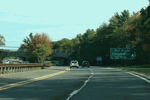
This 2015 photo shows the eastbound Northern State Parkway at EXIT 41 (Wolf Hill Road) in Dix Hills. (Photo by David Golub, www.eastcoastroads.com.) |
||
|
CURRENT AND FUTURE IMPROVEMENTS: According to the NYSDOT, the Northern State Parkway handles approximately 150,000 vehicles per day (AADT) through western Nassau County, approximately 90,000 vehicles per day through eastern Nassau County, and approximately 70,000 vehicles per day through western Suffolk County. |
||
|
To accommodate heavy traffic loads safely, the NYSDOT and the New York Metropolitan Transportation Council have scheduled the following projects along the parkway: |
||
|
During the late 1990s and early 2000s, the NYSDOT studied various plans to relieve congestion on the Northern State Parkway in its long-range "LITP 2000" study. After studying plans to convert the parkway into an HOV-only facility during rush hours, and a variation ("HO/T 2+") that would allow single-occupancy vehicles to travel on the parkway by tolling these motorists, the NYSDOT ultimately dropped both plans, and instead called for the construction of HOV lanes from EXIT 29A (I-495 / Long Island Expressway) east to EXIT 37A (I-495 / Long Island Expressway). The Northern State Parkway HOV lanes are expected to handle the new "Long Island Rapid Commute" (LIRC) vehicles envisioned by the "LITP 2000" plan. According to the NYSDOT, the LIRC articulated vehicles would travel on dedicated new and existing HOV lanes on controlled-access highways, as well as on existing arterial roads. |
||

|
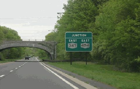
This 2002 photo shows the Northern State Parkway approaching its eastern terminus at Veterans Memorial Highway (NY 347 and NY 454) in Hauppauge. (Photo by Jon Lebowitz.) |
||

|
EASTERN EXTENSION PLANS: In 1936, the Regional Plan Association (RPA) recommended the construction of an expressway and parkway network covering the entire New York metropolitan area. One proposal in this network called for the extension of the Northern State Parkway east to Orient Point State Park, at the eastern end of Long Island's North Fork. A spur of the Northern State Parkway extension was to extend north into Wildwood State Park in Wading River. The proposed eastern extension of the Northern State Parkway to Orient Point was never officially mapped by the LISPC. |
||
|
In 1963, Suffolk County Executive H. Lee Dennison proposed to the LISPC that an extension of the Northern State Parkway be constructed east to Smithtown at Caleb Smith State Park. The extension was to permit access to the former Wyandanch Preserve, a 543-acre parcel that had recently been purchased by New York State. A connection to NY 25 (Jericho Turnpike) was to be provided at the vicinity of Old Willets Path (Suffolk CR 108) in Smithtown. |
||
|
The Northern State Parkway Extension was to continue south along the western edge of Connetquot State Park (the former Sportsmen's Preserve), where a new entrance to the park was to be constructed from the parkway. The parkway extension was to terminate at the Heckscher State Parkway between EXIT 43A (Suffolk CR 17-Carleton Avenue) and EXIT 44 (NY 27-Sunrise Highway) in Islip Terrace. |
||

|
The Northern State Parkway six-lane widening project should be continued east to the its terminus at Veterans Memorial Highway (NY 347-NY 454) in Hauppauge. As part of the widening project, some of the older, tighter cloverleaf interchanges should be converted into four-ramp diamond interchanges. Others, such as those at EXIT 35 (NY 106-NY 107) and EXIT 40 (NY 110), should be converted into single-point-urban-interchanges (SPUI's). Additionally, the eastbound EXIT 34 (Brush Hollow Road) should be eliminated (access would be obtained from the southbound Wantagh State Parkway). |
||

|
SOURCES: "Freeways Are Now Urged," The New York Times (12/13/1936); Northern State Parkway Extension," Suffolk County Planning Department (1963); "Expressway Plans," Regional Plan Association News (May 1964); "LI Parkway Link Will Be Widened" by Joseph C. Ingraham, The New York Times (11/29/1965); Arterial Progress 1959-1965, Triborough Bridge and Tunnel Authority (1965); Public Works: A Dangerous Trade by Robert Moses, McGraw-Hill (1970); The Power Broker by Robert A. Caro, Vintage Books-Random House (1974); History of the Long Island State Parkway System, New York State Department of Transportation (1985); Robert Moses: Single-Minded Genius by Joann P. Krieg, Heart of the Lakes Publishing (1989); "Major Road Projects Wish List," Newsday (2/22/1990); "On the Roads: Things Looking Up" by Sylvia Adcock, Newsday (5/22/1998); "Ask Dr. Conehead" by Kim Nava, Newsday (9/26/1999); "The Northern State Parkway: Living with Change" by Domenico Annese and Jaime Vasquez, National Trust for Historic Preservation (2000); "Seeking Ways To Uncork the 110 Bottleneck" by John Valenti, Newsday (6/11/2000); "Route 110 Plan Worries Some Merchants" by Linda Saslow, The New York Times (9/02/2006); New York Metropolitan Transportation Council; S. Berliner, III; Daniel T. Dey; Vince Fitzgerald; Fred Hadley; Ralph Herman; Nick Klissas; Nathan W. Perry; Jim Wade. |
||

|
NORTHERN STATE PARKWAY LINKS: |
||
|
NORTHERN STATE PARKWAY CURRENT TRAFFIC MAPS: |
||
|
NORTHERN STATE PARKWAY VIDEOS: |
||

|
THE EXITS OF METRO NEW YORK: |
||

|
Back to The Roads of Metro New York home page. |
||
|
Site contents © by Eastern Roads. This is not an official site run by a government agency. Recommendations provided on this site are strictly those of the author and contributors, not of any government or corporate entity. |
||