 |
|
|
|
|
|
|
|
|
|
|
|
|
|
|
|
|
|
|
|
|
|
|
|
|
|
|
|
|
|
|
|
|
|
|
|
|
|
|
|
|
|
|
|
|
|
|
|
|
|
|
|
|
|
|
|
|
|
|
|
|
|
|
|
|
|
|
|
|
 |
|
|
|
|
 |
|
 |
|
|
|
|
|
|
|
|
|
|
|
|
|
|
|
|
 |
|
|
|
|
|
|
|
 |
|
|
|
|
|
|
|
|
|
|
|
|
|
|
|
|
|
|
|
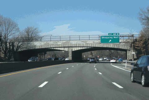
This 2016 photo shows the northbound Meadowbrook State Parkway at EXIT M2 (Zeckendorf Boulevard) in East Garden City. (Photo by Steve Anderson.)
|
|
|
|
|
|
|
|
|
 |
|
|
|
|
 |
|
|
|
|
|
|
|
|
Length:
Constructed:
NYSDOT Reference Route:
|
|
|
|
|
|
|
|
|
12.5 miles (20.2 kilometers)
1932-1956
NY 908E
|
|
|
|
|
|
|
|
|
 |
|
 |
|
|
|
|
|
Passenger cars only north of EXIT M9 (Merrick Road).
Height restrictions apply.
|
|
|
|
|
|
|
|
|
|
|
|
 |
|
|
|
|
 |
|
|
|
|
|
A SECOND ROUTE TO JONES BEACH: Since opening in 1929, Jones Beach State Park, which was named after an Irish immigrant and privateer who established a whaling station in the area in 1692, has been an immensely popular recreational destination for families. By 1931, summer weekends were recording attendance numbers of 100,000 people per day. The four-lane Wantagh State Parkway, which at the time was the only route leading to Jones Beach, was becoming inadequate to serve beach traffic. To alleviate Jones Beach-bound traffic, the Meadowbrook State Parkway was constructed.
|
|
|
|
|
|
|
|
|
|
|
|
|
|
|
|
|
|
|
|
|
Construction of the Meadowbrook State Parkway began in earnest in 1932, and included the construction of the Loop Parkway spur to Point Lookout. This initial four-mile-long section from Jones Beach north to EXIT M9 (Merrick Road) in Freeport opened in the fall of 1934. It originally featured two 24-foot, two-lane roadways separated by an 18-foot-wide grassed median. The causeway leading to Jones Beach was constructed on hydraulic fill over marsh and islands across the bay on lands donated to the state by the Town of Hempstead.
Because of the depressed economic conditions at the time, the Long Island State Park Commission (LISPC) borrowed the $5 million cost of construction from the Reconstruction Finance Corporation (RFC), a Federal-level New Deal agency.
PARKWAY EXTENSIONS: In 1935, the Meadowbrook State Parkway was extended 2.8 miles north to the Southern State Parkway in North Merrick. This section was constructed by the New York State Department of Public Works (NYSDPW) and was separately financed. The roadway design was the same as that featured on the initial section.
|
|
|
|
|
|
|
|
|
|
|
|
One year later, Moses released plans for an extension of the Meadowbrook State Parkway north to the Northern State Parkway in Carle Place. Although land for the right-of-way had been acquired by Nassau County, construction of the parkway was delayed by the depression and World War II.
In the early 1950's, officials from the NYSDPW considered construction of a north-south expressway between Freeport and Roslyn. After encountering opposition along the route, officials backed away from this idea, deciding instead to build a parkway along the existing Meadowbrook right-of-way between the Northern State and Southern State parkways.
|
|
|
|
|
|
|
|
|
|
|
|
|
|
|
|
|
|
|
|
|
|
|
|
|
The Meadowbrook State Parkway extension, built by the NYSDPW and financed by Jones Beach State Parkway Authority bonds, was completed in 1956. It was constructed with two 24-foot-wide roadways, each carrying two lanes of traffic, and a 29-foot-wide median to separate the two roadways. The bridges separating grades were constructed to permit the future widening of the parkway from four to six lanes.
WIDENING PROJECTS: The popularity of Jones Beach continued to grow in the postwar era, and to meet the demand, the LISPC widened the Meadowbrook State Parkway from four to six lanes south of EXIT M6 (Southern State Parkway). This widening, which was financed by Jones Beach State Parkway Authority bonds, took place between 1955 and 1965.
The postwar era also brought rapid development in the "Nassau Hub" (Roosevelt Field and Mitchel Field) area, prompting officials to widen the remainder of the Meadowbrook State Parkway between the Southern State Parkway in North Merrick and the Northern State Parkway in Carle Place. During this project, the existing two-lane roadways were expanded to three 12-foot-wide lanes in each direction, and by doing so, the grassed median was narrowed from 29 feet to five feet. With the reduction of median space caused by the widening, cable-reinforced timber guide rail was installed to prevent accidental center mall crossings. New collector-distributor (C/D) roads were also constructed to serve Mitchel Field and the new Nassau Coliseum. (The Glen Curtiss Boulevard overpass in Uniondale hints at a possible future southern extension of the C/D roads.) This expansion project was completed in 1971.
|
|
|
|
|
|
|
|
|
|
|
|
|
|
|
 |
|
|
|
|
|
|
|
|
|
|
|
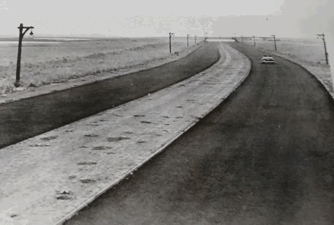
This photo shows the Meadowbrook State Parkway looking south toward the Fundy Channel Bridge and the Loop Parkway not long after it opened in 1934. (Photo supplied by Steven Waldman.)
|
|
|
|
|
|
|
|
|
|
|
|
|
|
 |
|
|
|
|
|
PRESENT IMPROVEMENTS: In 1977, maintenance of the Meadowbrook State Parkway was transferred from the LISPC to the New York State Department of Transportation (NYSDOT), although ownership remained under the jurisdiction of the New York State Office of Parks, Recreation and Historic Preservation (NYSOPRHP). To accommodate the increase in traffic volume and speed, and to address the accident history, the NYSDOT began to modify the parkway in accordance with Federal and state traffic safety guidelines.
|
|
|
|
|
|
|
|
|
|
|
|
|
|
In 1978, one year after the parkways were transferred from the LISPC to the NYSDOT, tolls were removed for motorists using the Meadowbrook Causeway in the area of Jones Beach.
For many years, the substandard interchange between the Meadowbrook State Parkway and the Northern State Parkway was the site of many accidents. From the westbound Northern State Parkway, one had to make a "U-turn" onto the eastbound lanes (using EXIT 31 / Glen Cove Road) in order to get onto the southbound Meadowbrook Parkway. After two decades of community debate and several years of reconstruction, the interchange between the two parkway, which featured new, wider main roadways and direct ramps, was completed in 1992.
During the late 1980s and early 1990s, new MUTCD-compliant signs and high-intensity lighting were installed along the parkway from Merrick Road north to the Northern State Parkway. More modern safety measures such as concrete ("Jersey") barriers and sand-filled impact attenuators replaced existing safety measures.
Most of these improvements, however, have occurred north of the Southern State Parkway. This is because the section of the Meadowbrook State Parkway south of the Southern State Parkway is designated as a "Robert Moses National Register Parkway." In this segment, many facets of the original parkway design, including the guardrails and landscaping, are protected. The new lighting fixtures (installed in 2001) south of EXIT M9 (Merrick Road) are replicas of the original wooden lightposts, but reflect modern design standards.
According to the NYSDOT, the Meadowbrook State Parkway handles approximately 125,000 vehicles per day (AADT) between the Northern State and Southern State parkways, approximately 75,000 vehicles per day from the Southern State Parkway south to EXIT M9 (Merrick Road), and approximately 30,000 vehicles per day south of Merrick Road. In 1998, the parkway was ceremonially renamed the "Norman Levy Memorial Parkway" after the passing of the long-serving state senator remembered for transportation issues.
CURRENT AND FUTURE IMPROVEMENTS: The NYSDOT and the New York Metropolitan Transportation Council outlined the following improvements to the Meadowbrook State Parkway:
$5.4 million rehabilitation of the Meadowbrook Causeway between the Fundy Creek Bridge and the Sloop Channel Bridge, including the area of EXIT M10 (Loop Parkway) and the Jones Beach fee booth plaza; completed in 2001.
$14 million extension of the northbound C/D (collector-distributor) road from EXIT M4 (NY 24) north to EXIT M3 (Stewart Avenue and Merchants Concourse); project postponed.
$69 million reconstruction of the interchange between the Meadowbrook State and Southern State parkways.
Longer-term measures also have been planned to deal with the increase in traffic. In 1990, the Long Island Regional Planning Board comprehensive highway plan called for the expansion from six to ten lanes between the Northern State and Southern State parkways. A decade later, the NYSDOT scaled back the 1990 plans, and instead called for the construction of HOV lanes between the Northern State and Southern State parkways.
|
|
|
|
|
|
|
|
|
|
|
|
The Meadowbrook State Parkway HOV lanes are expected to handle the new "Long Island Rapid Commute" (LIRC) vehicles envisioned by the "LITP 2000" plan. According to the NYSDOT, the LIRC articulated vehicles would travel on dedicated new and existing HOV lanes on controlled-access highways, as well as on existing arterial roads.
|
|
|
|
|
|
|
 |
|
|
|
|
|
|
|
|
|
|
|
|
|
|
 |
|
|
|
|
|
|
|
|
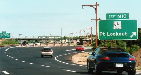
This 2001 photo shows the southbound Meadowbrook State Parkway at EXIT M10 (Loop Parkway), just before the fee booths for Jones Beach State Park. The NYSDOT installed the "new-generation woodie" lightposts during the spring of 2001 as part of a parkway rehabilitation project. (Photo by David J. Greenberger.)
|
|
|
|
|
|
|
|
|
|
|
|
|
|
 |
|
|
|
|
|
The Meadowbrook State Parkway should be widened between the Northern State Parkway and the Southern State Parkway. This can be done in one of two ways:
Expansion of the main roadway from six to eight general-use lanes.
Extension of the C/D (collector-distributor) roads north to EXIT M1 (Old Country Road). That is, the existing C/D roads that serve the Mitchel Field area should be extended north to serve the Roosevelt Field area.
|
|
|
|
|
|
|
|
|
|
|
|
|
|
In both cases, interchange improvements should be implemented as required to improve safety and traffic flow.
|
|
|
|
|
|
|
|
|
|
|
|
|
|
|
|
|
|
|
 |
|
|
|
 |
|
|
|
|
|
SOURCES: "New Highways Across Long Island To Link North and South Shores," The New York Times (11/15/1936); The Power Broker by Robert A. Caro, Vintage Books-Random House (1974); History of the Long Island State Parkway System, New York State Department of Transportation (1985); "Jones Beach State Parkway Channel Bascule Bridge" in Historic American Engineering Record, National Park Service (1987); Robert Moses: Single-Minded Genius by Joann P. Krieg, Heart of the Lakes Publishing (1989); New York Metropolitan Transportation Council; Cynthia Blair; Daniel T. Dey; Ralph Herman; Nathan W. Perry; Jim Wade.
Meadowbrook State Parkway shield by Ralph Herman.
Lightposts by Jeff Saltzman.
HOV sign by C.C. Slater.
|
|
|
|
|
|
|
|
|
|
|
|
|
|
|
|
 |
|
|
|
|
|
|
|
|
|
 |
|
|
|
|
|
|
|
|
|
 |
|
|
|
|
|
|
|
|
 |
|
|
|
|
|
|
|
|
 |
|
|
|
|
|
THE EXITS OF METRO NEW YORK:
Meadowbrook State Parkway exit list by Valerie Deane.
|
|
|
|
|
|
|
|
|
|
|
 |
|
|
|
|
|
|
|
|
|
|
|
|
Site contents © by Eastern Roads. This is not an official site run by a government agency. Recommendations provided on this site are strictly those of the author and contributors, not of any government or corporate entity.
|
|
|
|
|
|
|
|
|
|