 |
|
|
|
|
|
|
|
|
|
|
|
|
|
|
|
|
|
|
|
|
|
|
|
|
|
|
|
|
|
|
|
|
|
|
|
|
|
|
|
|
|
|
|
|
|
|
|
|
|
|
|
|
|
|
|
|
|
|
|
|
|
|
|
|
|
|
|
|
|
|
|
|
|
|
|
|
|
|
|
|
|
|
|
|
|
|
|
|
|
|
|
|
|
|
|
|
|
|
|
|
|
|
|
|
|
|
|
|
|
|
|
|
 |
|
|
|
|
 |
|
 |
|
|
|
|
|
|
|
|
|
|
|
|
|
|
|
|
 |
|
|
|
|
|
|
|
|
|
|
|
|
|
|
|
 |
|
|
|
|
|
|
|
|
|
|
|
This 2001 photo shows the westbound Long Island Expressway (I-495) approaching the Queens-Midtown Tunnel and midtown Manhattan. (Photo by Mike Tantillo.)
|
|
|
|
|
|
|
|
|
 |
|
|
|
|
 |
|
|
|
|
|
|
|
|
|
70.8 miles (114.2 kilometers)
1939-1972
|
|
|
|
|
|
|
|
|
|
|
|
|
|
|
|
|
|
"I drive the LIE. Please pray for me." -- from a bumper sticker
|
|
|
|
|
|
|
|
|
|
|
|
BEGINNING OUT OF THE TUNNEL: The first section of the Long Island Expressway, a one-mile-long, six-lane viaduct over Long Island City, Queens, opened to traffic in 1940 after one year of construction. The new viaduct, whose opening coincided with that of the twin-tube Queens-Midtown Tunnel at its western terminus, had its eastern terminus at the new Brooklyn-Queens Expressway (I-278). At its highest point, the viaduct rises 106 feet above Dutch Kills.
|
|
|
|
|
|
|
 |
|
|
|
|
|
|
|
|
|
|
In 1941, the New York City Planning Commission proposed an extension of the "Midtown Highway" east to the city line as follows:
Midtown Highway: Connecting to the recently completed section between the Queens-Midtown Tunnel and the Brooklyn-Queens Connecting Highway (Expressway), this section will serve to extend the express highway from the cloverleaf at the Connecting Highway to the Rego Park section of Queens, where it connects with Woodhaven, Queens and Horace Harding boulevards. It will serve to divert large volumes of traffic from the congested portions of Queens Boulevard and will provide an additional much-needed express facility leading into Manhattan. Estimates prepared by the Queens Borough President's engineers indicate that the cost of this improvement would be $5,700,000. In adopting this route, the Commission does not now approve any specific plans, but indicates the desirability of a general route that requires further study as to its precise location, details of treatment and connections to other major routes.
Horace Harding Express Highway: Conversion of this boulevard to an express highway would be desirable in order to provide through express service from Queens Boulevard and the proposed Midtown Highway to the city line. The City owns a sufficient right-of-way for the conversion to an express highway.
MOSES CONSOLIDATES CONTROL: When the Queens-Midtown Tunnel was being constructed in the late 1930's, New York City arterial coordinator Robert Moses contended that a highway link was unnecessary. It had been speculated that because the tunnel was under the jurisdiction of the New York City Tunnel Authority, and therefore not under Moses' jurisdiction, he did not want the highway built.
In 1945, after a nine-year-long power struggle, Mayor Fiorello LaGuardia relented to Moses, allowing him to take over the tunnel authority to form a new agency, the Triborough Bridge and Tunnel Authority (TBTA). Subsequently, Moses' position on the highway link to the tunnel changed. In the immediate post-war years, the TBTA funded a $32.5 million extension of the elevated highway, now called the "Queens-Midtown Expressway," out to Queens Boulevard. This segment carried signs for NY 24.
East of Queens Boulevard (NY 25), the future route of the LIE continued east along four-lane Horace Harding Boulevard (then NY 25D). In the 1920's, Harding, a former banker who served as president of the New York, New Haven and Hartford Railroad and of the Bronx Gas and Electric Company, supported construction of a highway from Queens Boulevard in Elmhurst to Shelter Rock Road in Manhasset. This highway, which was constructed to improve access to a country club, was named after Harding following his death in 1929.
|
|
|
|
|
|
|
|
|
|
|
|
|
|
|
|
|
|
|
 |
|
|
|
|
 |
|
 |
|
|
|
|
|
|
|
|
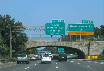
LEFT: This 1959 photo shows construction underway at EXIT 40 (NY 25 / Jericho Turnpike) in Jericho. A sign along Jericho Turnpike shows a map of the entire project. Just ahead, the first overpass to feature aluminum (rather than steel) construction in the country is being erected to carry the LIE over Route 25. (Photo by Triborough Bridge and Tunnel Authority.) RIGHT: This 1961 photo shows the Long Island Expressway at EXIT 24 (Kissena Boulevard) in Flushing. (Photo by Library of Congress, Prints and Photographs Division, Gottscho-Schleisner Collection, LC-G613- 76852.)
|
|
|
|
|
|
|
|
|
|
|
|
|
|
 |
|
|
|
|
|
A ROUTE THROUGH THE POTATO FIELDS: As early as 1949, the New York State Department of Public Works (NYSDPW) recommended the construction of a controlled-access highway that would be open to all traffic. Part of the state's 1,780-mile "interstate and interregional highway system," the proposed expressway was to extend from New York City east to Orient Point. When the NYSDPW announced the proposal, Long Island was still largely agricultural, but new suburban communities were developing rapidly, particularly in Nassau County.
|
|
|
|
|
|
|
|
|
|
|
|
|
|
On September 1, 1953, Newsday disclosed plans for a 70-mile-long, six-lane highway between Manhattan and the east end of Long Island. According to a letter addressed to then-Governor Thomas E. Dewey, Moses argued that the Long Island Expressway - originally called the "Central Motor Expressway" - was the only logical solution to present and future traffic problems:
The proposed Long Island Expressway is a most important part of the arterial highway program which will serve all of Long Island, that is, Brooklyn, Queens, Nassau and Suffolk counties, with a combined population of over 5,500,000. The backbone of this program is a 70-mile expressway for mixed traffic from Manhattan to Riverhead, Suffolk County. The building of this vitally needed express artery has the full approval and support of the authorities of both Nassau and Suffolk counties, and has been recommended by the Temporary State Highway Finance Committee.
|
|
|
|
|
|
|
|
|
|
|
|
|
|
Early completion of this comprehensive expressway system from Manhattan and Queens, through Nassau to the county seat of Suffolk County, is the only logical solution to the intolerable congestion resulting from the rapid increase of building subdivisions, extraordinary population growth and large increase in motor vehicle registration. Almost daily, the remaining estates and large acreages on Long Island are being sold to developers. Unless the plans are progressed and rights-of-way are acquired promptly, the route will traverse built-up communities, with enormous increases in cost and the difficulties of demolition or relocation of homes and businesses.
|
|
|
|
|
|
|
|
|
|
|
|
|
|
|
|
|
|
Dewey approved the Long Island Expressway on March 27, 1954. The LIE, which had an original design capacity of 80,000 vehicles per day (AADT), was to cost $500 million. Its construction was to be funded by matching state and Federal funds.
The New York State Department of Public Works (NYSDPW) defined the route of the Long Island Expressway through Queens, Nassau and Suffolk counties as follows:
Queens-Midtown Expressway: from Queens-Midtown Tunnel approach to Queens Boulevard.
Horace Harding Expressway: from Queens Boulevard to the Nassau county line.
Long Island Expressway: Beginning at a point on the New York City line in the vicinity of the village of Lake Success, thence running generally easterly through or near the hamlet of Jericho to the Nassau-Suffolk county line in the vicinity of the hamlet of Plainview. Beginning at the Suffolk-Nassau county line in or near the hamlet of Melville, thence running generally easterly through or near the hamlets of Ronkonkoma, Medford Station, Yaphank, Manorville and Riverhead to a state highway in or near the hamlet of Mattituck, including a spur connection to the Sunrise Highway Extension.
According to the Long Island Expressway report commissioned by the NYSDPW in 1956, Lockwood, Kessler and Bartlett presented the following statistics on Long Island's east-west traffic:
State traffic records for 1954 show an annual average daily traffic volume of about 100,000 vehicles crossing the Nassau-Suffolk county line. One-way design hour traffic totaled for these routes is 10,000 vehicles per hour approximately 900 per hour per lane. Further east in Suffolk County, the same records show total east-west daily volumes of 18,000 to 20,000 vehicles per day. One-way design hour traffic totals about 2000 vehicles per hour, or 500 to 650 vehicles per lane.
It was feared that commercial and industrial growth would be stifled without the expressway. In 1958, officials claimed that there would be a potential loss of business and jobs if the expressway were not finished by its original completion date of 1961.
|
|
|
|
|
|
|
|
|
|
|
|
|
|
 |
|
 |
|
|
|
|
|
|
|
|
Two 1997 views of the double-decked section of the Long Island Expressway (I-495), at its intersection with the Brooklyn-Queens Expressway (I-278) in Maspeth, Queens. The LIE upper level carries through traffic, while the LIE lower level carries traffic to and from the BQE. The LIE-BQE interchange, built as a simple cloverleaf in the early 1950's, was reconstructed in its current configuration in the late 1960s. (Photos by Jeff Saltzman.)
|
|
|
|
|
|
|
|
|
|
|
|
|
|
 |
|
|
|
|
|
THE LIE TAKES SHAPE: Between 1954 and 1958, the NYSDPW constructed the Horace Harding Expressway - by now called the Long Island Expressway along its mainline -from EXIT 19 east to EXIT 32 (Little Neck Parkway), just shy of the Queens-Nassau border. (However, one Queens section of the LIE did not open until 1960 so that a high-volume interchange could be constructed at the Clearview Expressway.)
The new expressway went over the route of Horace Harding and Nassau boulevards (the LIE service roads in Queens still bear the "Horace Harding" name), which had the designation NY 25D. Not long after construction crews arrived at the Queens-Nassau border in September 1957, the expressway was given the NY 24 designation. (Hempstead Turnpike then assumed the NY 24A designation.)
|
|
|
|
|
|
|
|
|
|
|
|
|
|
In October 1958, the first Long Island section of the LIE opened between EXIT 32 and EXIT 39 (Glen Cove Road) in East Hills. That same month, the designation of Interstate highways in New York State began. The LIE received the I-495 designation from the Queens-Midtown Tunnel to the Clearview Expressway, which was just beginning construction at that time. (The I-495 designation was also to go to the never-built Mid-Manhattan Expressway.) East of the Clearview, the LIE retained the NY 24 designation.
Just east of the newly opened section in western Nassau County, Moses made a deal with Charles E. Wilson, former president of General Motors and defense secretary under President Dwight Eisenhower. Under the deal, which was brokered between the NYSDPW and the Federal government, Wilson, who was deep in debt, sold his parcels of land in Old Westbury to the NYSDPW. Moses could build the Long Island Expressway through Old Westbury - the same area that the Northern State Parkway avoided in the "Objector's Bend" deal a quarter century earlier - but could not construct interchanges for a four-mile stretch.
RAIL LINE ALONG THE LIE MEDIAN NIXED: When planners proposed a rapid transit line down the center median of the LIE, Moses replied by saying that it was "impossible." However, Day and Zimmerman, an independent consulting agency hired by the Metropolitan Rapid Transit Commission (forerunner to the MTA), thought otherwise. From Robert A. Caro's The Power Broker:
One Day and Zimmerman alternative, for example, was to lay tracks down the expressway center mall from Marathon Parkway into Corona, leave the expressway at Flushing Meadows Park, cut across its northeastern corner to link up with the IRT subway near its 111th Street station and follow that line (which "has ample capacity to accommodate" the added traffic) to Times Square. The total cost of building such a line -- the total cost of the additional forty feet of expressway right-of-way, of bridges at grade separations, of electric substations, of eleven large, modern passenger stations with parking garages at the eleven major avenues intersecting with the expressway within that seven-mile stretch, of every piece of modern rapid transit equipment desirable -- would be only $20,830,000.
Similar plans to create a Long Island Rail Road line down the center median of the expressway in Nassau and Suffolk counties were also defeated.
|
|
|
|
|
|
|
|
|
|
|
|
|
|
|
 |
|
|
|
|
|
|
|
|
This 2014 photo shows the Long Island Expressway at EXIT 22 (I-678 / Van Wyck Expressway), looking east from Flushing Meadows-Corona Park in Queens. Originally constructed in the late 1930s as "World's Fair Boulevard," this section of the LIE was built in the mid-1950s. (Photo by Dave Watts.)
|
|
|
|
|
|
|
|
|
|
|
|
|
|
 |
|
|
|
|
|
MARCHING ACROSS THE ISLAND: Little by little, the Long Island Expressway made its way across Nassau and Suffolk counties. In 1960, the segment between EXIT 39 and EXIT 41 (NY 106 and NY 107) in Jericho opened. By mid-1962, the LIE crossed the Nassau-Suffolk border, ending at EXIT 49 (NY 110) in Melville. One year later, the LIE was completed out to EXIT 52 (Suffolk CR 4 / Commack Road) in Dix Hills. In 1964, another section opened out to EXIT 57 (NY 454 / Veterans Memorial Highway) in Islandia. By the end of 1966, the expressway was completed out to EXIT 61 (Suffolk CR 19 / Patchogue-Holbrook Road) in Holbrook.
|
|
|
|
|
|
|
|
|
|
|
|
|
|
|
In 1962, the LIE east of the Clearview Expressway was changed from NY 24 to NY 495, for the purpose of consistency with the I-495 segment in Queens. (West of the BQE, the LIE west of the BQE was dually signed as I-495 and NY 24 until the early 1970s.) In addition, Hempstead Turnpike, which had been NY 24A since 1957, got back its original NY 24 designation.
|
|
|
|
|
|
|
 |
|
 |
|
|
|
|
|
|
|
|
|
|
|
|
|
|
An article in The New York Times Magazine in 1967 foretold of future development on Eastern Long Island as follows:
Riverhead now looks like a county seat in the Midwest farm belt. Surrounded by dusty potato fields at the head of Peconic Bay, between Long Island's north and south flipper-like tail forks, this agricultural market town, after it is linked with the Expressway, may be transformed into the industrial hub of a new Northeast coastal network of air, high-speed rail and highway transportation.
DOUBLE-DECKING THE LIE: Only a few years after its first section opened, the Long Island Expressway was fast becoming known as "the world's largest parking lot." In 1963, Henry Barnes, the New York City transportation commissioner, proposed a $94 million second deck on the Long Island Expressway throughout Queens. The second deck was to be reversible, going westbound in the morning and eastbound in the evening, and would go along with four to six extra lanes. As he saw it, the only obstacle was "aesthetics." By that time, daily volume had averaged 130,000 vehicles.
At its interchange with the Brooklyn-Queens Expressway (I-278) and Maurice Avenue (EXITS 17-18), the Long Island Expressway is double-decked for about 1.5 miles. This was part of a four-year, $75 million reconstruction project that began in 1966.
|
|
|
|
|
|
|
|
|
|
|
|
|
|
|
 |
|
|
|
|
|
|
|
|
This 2014 photo shows the westbound Long Island Expressway (I-495) approaching EXIT 31 (Cross Island Parkway) in Douglaston, Queens. Until 2003, EXIT 31 was for Douglaston Parkway while EXIT 30 was for the Cross Island Parkway. Note the lack of a shoulder in the rebuilt expressway section. (Photo by Dave Watts.)
|
|
|
|
|
|
|
|
|
|
|
|
|
|
|
|
|
|
|
|
AN END IN SIGHT: At the beginning of 1970, the Long Island Expressway was still 22 miles from its planned terminus in Riverhead. In the spring of that year, a 20-mile-long section of the expressway between EXIT 61 in Holbrook and EXIT 71 (NY 24-Suffolk CR 94) in Calverton was completed.
On June 28, 1972, the final segment east to EXIT 73 (Suffolk CR 58 / Old Country Road) was completed. Newsday chronicled the opening of the final two-mile segment as follows:
|
|
|
|
|
|
|
|
|
|
|
|
|
|
For the record, the first car on the new section, that convertible, was driven by Bruce Stasiuk, a Coram schoolteacher. Tom Bogacki went along for the ride. The adventurers arrived just after 9 AM and waited on the shoulder, just inside the barrier (at EXIT 71), for the cones to be lifted. "We didn't know whether to expect crowds or not," Stasiuk said. "This occasion is historical in many ways... maybe we'll change our names to Lewis and Clark."
|
|
|
|
|
|
|
|
|
|
|
|
AN EARLY VERSION OF HOV: In 1971, state and city traffic officials introduced the first exclusive bus lane (XBL) in New York City, following the success of the XBL lane on the NJ 495 Freeway (Lincoln Tunnel Approach). For a two-mile-long stretch between the Queens-Midtown Tunnel and the Brooklyn-Queens Expressway (I-278), the innermost eastbound lane is converted into a reversible lane for westbound buses and medallion taxis during the morning rush hour. The reversible XBL lane, which handles approximately 60 buses per hour, saves inbound bus riders an average of 12 minutes.
|
|
|
|
|
|
|
 |
|
|
|
|
|
|
|
|
|
|
To ease traffic bound for the Queens-Midtown Tunnel, the NYCDOT eased restrictions on the XBL lane on March 31, 2003. The inbound bus lane is how an HOV-3 lane, permitting motorists with three or more occupants to use the lane. A movable concrete ("Jersey") barrier separates inbound traffic on the HOV-3 lane from the two outbound traffic lanes. During the afternoon rush hour, the inbound HOV-3 lane reverts to outbound use.
HOPE FOR MASS TRANSIT ON THE LIE? By the 1970's, commuters were desperate to find ways to drive to work faster. In 1975, it was estimated that 1,000 cars parked each weekday morning on the shoulders of interchanges. The following measures were proposed as follows:
Park-and-ride lots: Beginning in 1975, and continuing over the next decade, new park-and-ride facilities were constructed at EXITS 41, 49, 52, 54, 56, 58, 61, and 63.
Bus-only lanes: In the mid-1970's, Lee Koppelman, the director of the Long Island Regional Planning Board, proposed that one of the three lanes in each direction be a bus-only lane. Koppelman contended that the capacity of this lane would be expanded from 4,500 people for hour to 20,000 people per hour. This proposal was an extension of the successful XBL lane in western Queens.
HOV lane: A high-occupancy vehicle lane was proposed for the LIE as early as the 1970's. However, after a 1978 NYSDOT survey determined that three-quarters of motorists said that they would not use a carpool-only lane, HOV lane plans would be shelved for another decade and a half.
Light rail: In 1978, Mayor Edward Koch proposed a light rail system that would run along the shoulders of the LIE. However, the money for this project was eventually diverted to other projects.
|
|
|
|
|
|
|
|
|
|
|
|
|
|
|
 |
|
|
|
|
|
|
|
|
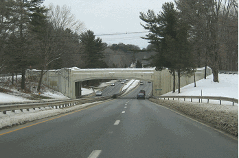
This 2007 photo shows the eastbound Long Island Expressway approaching EXIT 41 (NY 106-NY 107) in Jericho. (Photo by Steve Anderson.)
|
|
|
|
|
|
|
|
|
|
|
|
|
|
 |
|
|
|
|
|
FINALLY, SOME RECOGNITION: After decades of growth and intense lobbying, the Nassau-Suffolk region still did not have an Interstate highway. In 1983 - 13 years after New York State first applied for an Interstate designation for the expressway - the Federal Highway Administration (FHWA) gave the I-495 designation to the Long Island Expressway from the Clearview Expressway (I-295) east to Riverhead. (FHWA route logs from that era list the route as the "Harry S Truman Expressway.") This move provided a continuous Interstate highway from the Queens-Midtown Tunnel to eastern Long Island.
|
|
|
|
|
|
|
|
|
|
|
|
|
|
TURNING ON THE LIGHTS: For many years, motorists were cast into darkness as they crossed the Queens-Nassau border. Despite pleas from local officials and the New York chapter of AAA, plans to illuminate the LIE went nowhere. It was not until 1980, when the first lightposts were installed in western Nassau County, that lights appeared on the expressway. The lighting project continued through eastern Nassau in 1981, and through western Suffolk in 1982. In 1998, lights were extended east from EXIT 62 to EXIT 64. In 2002, the gap in highway lighting in Old Westbury between EXIT 39 and EXIT 40 will be filled as part of the HOV project.
CLOSING THE SERVICE ROAD GAPS: In 1981, plans were announced to complete gaps in the expressway's service roads between EXIT 31 (Cross Island Parkway) in Douglaston and EXIT 64 (NY 112) in Medford. Current NYSDOT plans call for an extension of service roads further east to EXIT 67 (Suffolk CR 21).
Once again, community opposition stopped the construction of continuous service roads. Fearing that service roads were incompatible with the nature of the Syosset-Woodbury area, residents stopped the service roads through EXIT 44 (NY 135 / Seaford-Oyster Bay Expressway.) This LIE service road "gap" remains today.
STAYING "INFORMED:" Between 1983 and 1987, the Long Island Expressway, Northern State Parkway and intersecting arterials were tied into a network of roadbed sensors, overhead electronic signs and timed ramp signals. The INFORM system, which operates out of Hauppauge, was designed to ease traffic flow 24 hours a day, seven days a week. While such systems are relatively commonplace today, it was groundbreaking at that time. (A similar, far less reaching system was tested on the LIE in Queens and Nassau during the mid-1970s.)
MORE CAPACITY: With daily volumes approaching 200,000 vehicles per day along some sections, plans were announced to add capacity to the Long Island Expressway. In an October 1986 preliminary report entitled ''Long Island Expressway: Fourth Lane,'' the NYSDOT said, as have others before and since, that there was a need to improve capacity in the expressway corridor from New York City east. Because of the congested nature of much of Long Island, building new highways was not considered practical along the east-west corridor. Instead, attention was focused on ways to improve existing capacity. Toward the end of the 1980s, debate had centered on the following two alternatives: adding two new lanes restricted to HOV use, or adding four lanes open to all traffic.
|
|
|
|
|
|
|
|
|
|
|
|
|
|
|
 |
|
|
|
|
|
|
|
|
This 2014 photo shows the eastbound Long Island Expressway (I-495) at EXIT 53 (Sagtikos State Parkway) in Commack. This section of the expressway was rebuilt in the early 1990s. (Photo by Steve Anderson.)
|
|
|
|
|
|
|
|
|
|
|
|
|
|
|
|
|
|
|
|
HOV ON THE LIE: By the end of the 1980s, the NYSDOT finally determined that the fourth lane would be restricted to carpools and buses in peak hours, but could be used by all vehicles (except trucks) in off-peak hours. Construction of the lanes began in 1991 through western Suffolk County. The first section of the HOV lanes between EXIT 49 (NY 110) and EXIT 57 (NY 454) opened in May 1994. A second section between EXIT 40 (NY 25) and EXIT 49 opened in June 1998, and a third section between EXIT 57 and EXIT 64 (NY 112) opened in July 1999. The fourth (and so far, final) section of the HOV lanes opened between EXIT 32 (Little Neck Parkway) and EXIT 40 on June 30, 2005, nearly one year behind schedule.
|
|
|
|
|
|
|
|
|
|
 |
|
|
|
|
|
The HOV plan originally called for an expansion of the main roadway for an additional 1.1 miles from the Queens-Nassau border west to EXIT 31 (Cross Island Parkway). For several years, state officials battled against residents of Douglaston and Little Neck, who feared that the HOV lane expansion would precipitate lower property values, increase noise pollution, and destroy tulip and oak trees that shield the eastern Queens neighborhoods from the expressway.
|
|
|
|
|
|
|
|
|
|
|
|
|
|
In 1998, Governor George Pataki announced that he would kill the HOV lane proposal through Queens. Instead, the state converted the shoulders into a fourth lane in each direction during the early 2000's. Although there now is increased capacity on the LIE in eastern Queens, it came at a price. There is no breakdown lane in each direction, and there are very narrow grassed malls (where they do exist) between the expressway and the service roads.
In 2008, the NYSDOT said it would consider additional studies to permit unlimited access between the expressway's regular travel lanes and the HOV lanes, a practice that already is followed in California, Florida, and other states. The state has maintained the practice of separating traffic flows - permitting entry and exit only at designated points - because of the different speeds of these flows, particularly in peak travel periods.
The Long Island Expressway HOV lanes are expected to handle the new "Long Island Rapid Commute" (LIRC) vehicles envisioned by the "LITP 2000" plan. According to the NYSDOT, the LIRC articulated vehicles would travel on dedicated new and existing HOV lanes on controlled-access highways, as well as on existing arterial roads.
OTHER IMPROVEMENTS: In 1994, the interchange between the Long Island Expressway and the Sagtikos State Parkway (EXIT 53) was reconstructed. New ramps were provided to Commack Road (Suffolk CR 4) and Wicks Road (Suffolk CR 7). Three years later, a new exit for Robbins Lane (EXIT 43A) in Syosset opened to traffic. Both projects were constructed as part of the LIE mainline reconstruction project.
KEEPING IT MOVING: As early as 1961, "safe and reasonable" speeds along the Long Island Expressway were established at 50 MPH in Queens, 60 MPH in Nassau and 65 MPH in Suffolk (when it opened). Five years later, 40 MPH minimum-speed signs were posted along the expressway as part of a campaign to keep traffic moving. The 60 MPH and 65 MPH signs were replaced with 55 MPH signs in 1974.
In 1999, State Senator Owen Johnson (R-Babylon) and Assemblyman Robert Sweeney (D-Lindenhurst) introduced bills that would raise the speed limit on the Long Island Expressway to 65 MPH between EXIT 40 in Jericho and EXIT 73 in Riverhead. Johnson and Sweeney found support among upstate legislators who wanted to revert to the pre-1973 law, which set the state maximum freeway speeds at 65 MPH and let the NYSDOT determine these speeds. However, downstate legislators, led by Assembly Speaker Silver (D-Manhattan), held that the State Legislature, not the NYSDOT, determine speeds on each route segment. Despite qualified support from the LIA and the Automobile Club of New York for the new 65 MPH limit, the legislation was killed.
|
|
|
|
|
|
|
|
|
|
|
|
|
|
|
 |
|
|
|
|
|
|
|
|
This 2004 photo shows the eastbound Long Island Expressway at EXIT 68 (Suffolk CR 46 / William Floyd Parkway) in Yaphank. (Photo by David Golub.)
|
|
|
|
|
|
|
|
|
|
|
|
|
|
|
|
|
|
|
|
CURRENT AND FUTURE IMPROVEMENT PLANS: According to the NYSDOT, the Long Island Expressway handles approximately 210,000 vehicles per day (AADT) through the borough of Queens, approximately 190,000 vehicles per day through Nassau County, approximately 150,000 vehicles per day through western Suffolk County, approximately 100,000 vehicles per day through central Suffolk County, and approximately 30,000 vehicles per day near its eastern terminus.
|
|
|
|
|
|
|
|
|
|
|
|
|
|
In recent years, the NYSDOT and the New York Metropolitan Transportation Council have completed and scheduled the following projects along the Long Island Expressway:
In 2003, the NYSDOT rebuilt the Long Island Expressway from the Queens-Midtown Tunnel viaduct in Long Island City east to EXIT 22 (Grand Central Parkway and I-678 / Van Wyck Expressway) near Flushing Meadows-Corona Park. The five-year, $200 million project included mainline and ramp reconstruction, bridge rehabilitations and drainage improvements.
The NYSDOT and NYCDOT installed an ITS ("intelligent transportation") system along the Van Wyck-LIE corridor from the Kew Gardens interchange to the Queens-Midtown Tunnel. The $77 million project was completed in 2003.
The state is studying alternatives for a massive reconstruction of EXIT 22 (Grand Central Parkway / Van Wyck Expressway) through Flushing Meadows-Corona Park. Potential alternatives include widening the mainline LIE and relocating the LIE service roads, building direct ramps from the Grand Central Parkway to the LIE, and making improvements (such as the construction of a roundabout or jughandles) to the at-grade intersection between the LIE service roads and College Point Boulevard. The final alternative will be announced in 2008, with construction planned for sometime after 2010.
In 2003, the NYSDOT completed a two-year, $34 million reconstruction of EXIT 27 (I-295 / Clearview Expressway) in Bayside. Work crews reconstructed and realigned eight interchange ramps, rebuilt and widened six bridges, and lengthened acceleration-deceleration lanes. Upgrades were made to lighting, signs, guardrails and the INFORM system.
Also in 2003, the NYSDOT completed a three-year, $130 million project to rebuild EXIT 30 (Easthampton Parkway-Douglaston Parkway) and EXIT 31 (Cross Island Parkway) in Douglaston. The project included improvements in interchange geometry, bridge rehabilitations, and new ramps and collector-distributor (C/D) roads. (It also included the re-designation of EXIT 30 as "Easthampton Parkway-Douglaston Parkway" and EXIT 31 as "Cross Island Parkway.") Work on a complementary project to build a fourth general-use lane in each direction from EXIT 31 east to the Queens-Nassau border was completed in 2004.
The entire $880 million HOV project from the Queens-Nassau border to EXIT 64 in Medford was completed in June 2005. The final part of the HOV project between the Queens-Nassau border and EXIT 40 began in June 1999 with the widening of the LIE bridges over Lakeville Road, Community Drive, Searingtown Road, Willis Avenue and Post Avenue. New Interstate-standard bridges over the LIE were built at New Hyde Park Road, Shelter Rock Road, the LIRR Oyster Bay Branch, the Northern State Parkway connector, Glen Cove Road, Red Ground Road, Wheatley Road, Old Westbury Road, Steele Hill Road and Powell Lane. Currently, the LIE HOV lanes are so successful - they carry 36 percent of the roadway's passengers with 25 percent of its lanes - that officials considered raising the HOV restriction from two passengers to three. In 2006, Governor Pataki signed legislation permitting hybrid vehicles to use the LIE HOV lanes.
In 2005, the NYSDOT opened a permanent truck weigh station along the eastbound LIE on state-owned land just west of EXIT 48 (Round Swamp Road) in Plainview.
Between EXIT 49 (NY 110) and EXIT 63 (Suffolk CR 83), several eastbound LIE bridges over local roads are scheduled for widening to provide a standard 12-foot-wide shoulder width. In addition, three bridges over the LIE are scheduled to be widened to provide additional turn lanes. Originally scheduled for completion in 2005, the $45 million project has been delayed.
At EXIT 51 (NY 231), the LIE bridge over Deer Park Avenue was rehabilitated, and the exit ramps from the LIE were widened from one to two lanes. The $6.0 million project was completed in 2002.
Between EXIT 51 (NY 231) and EXIT 52 (Suffolk CR 4), the NYSDOT plans to upgrade the eastbound rest area beginning in 2008. The new $35 million year-round tourism facility will provide rest rooms, vending machines, travel information kiosks, and a police substation. The facility, which would be on the site of a current recharge basin, would accommodate parking for 150 cars and 27 trucks. The project would include replacement of the nearby Carll's Straight Path overpass, whose 14-foot underclearance is substandard. At the present time, there are no plans to rebuild the westbound rest area.
Between EXIT 63 (Suffolk CR 83) and EXIT 67 (Suffolk CR 21), new service roads were being constructed, and improvements to existing service roads were made. In addition, the half-diamond interchanges at EXIT 65 (Suffolk CR 16), EXIT 66 (Suffolk CR 101) and EXIT 67 were converted into full-diamond interchanges, and existing ramps were relocated. Much of the $52 million project was completed in 2002, except for the service roads between EXIT 66 and EXIT 67, which will be completed at a later date.
Beyond 2010, new HOV lanes may be built east from EXIT 64 (NY 112) to EXIT 68 (Suffolk CR 46), in anticipation of growing traffic demand in central Suffolk County through 2020.
FOURTH LANE THROUGH CENTRAL QUEENS PUT ON HOLD, AT LEAST FOR NOW: During the early 2000's, the NYSDOT initiated studies on building a fourth lane between EXIT 22 (Grand Central Parkway and I-678 / Van Wyck Expressway) and EXIT 31 (Cross Island Parkway). The state presented options from a simple $24 million "3R" (resurface, restore, and rehabilitate) project to a $409 million project that would add a fourth travel lane for HOV use. Facing opposition and potential lawsuits from local Queens officials and Community Board 11, the NYSDOT removed the fourth-lane options. The most likely option appears to be a $134 million project that would replace existing bridges with new bridges that would accommodate auxiliary lanes.
|
|
|
|
|
|
|
|
|
|
|
|
|
|
 |
|
|
|
|
|
YESTERDAY AND TODAY: These two photos show the end of the line for the Long Island Expressway (I-495). The left photo was taken in 1975, just three years after the LIE was completed. The right photo was taken nearly a quarter-century at a somewhat busier eastern terminus. (Left photo by Michael Summa via C.C. Slater; right photo by Steve Anderson.)
|
|
|
|
|
|
|
|
|
|
|
 |
|
|
|
|
 |
|
|
|
|
|
|
|
|
|
 |
|
|
|
 |
|
|
|
 |
|
|
|
|
|
This 1959 county planning map shows a proposed routing of the Long Island Expressway along the immediate Long Island Sound shoreline through the Town of Southold. This was followed by a 1961 plan to extend the expressway across Long Island Sound and Fishers Island to Watch Hill, Rhode Island. (Map supplied by Town of Southold Planning Department via Suffolk Times.)
|
|
|
|
|
|
|
|
|
|
|
 |
|
|
|
|
|
|
|
|
THE LIE "MONTAUK SPUR:" In the late 1950s, a spur of the Long Island Expressway was proposed between Calverton and Hampton Bays. The "Montauk Spur" was to have been built from a point between EXIT 70 (Suffolk CR 111) and EXIT 71 (NY 24) on the LIE, to a point on the then-proposed Sunrise Highway (NY 27) between EXIT 64 (Suffolk CR 104) and EXIT 65 (NY 24), connecting the two limited-access east-west routes. Many of the functions of the LIE Montauk Spur, which was to run parallel to the existing NY 24, were eventually filled by Suffolk CR 111 (Captain Daniel Roe Highway).
THE LIE "MATTITUCK EXTENSION:" In 1969, three years before the expressway reached Riverhead, the New York State Legislature approved a 13-mile extension beyond EXIT 73 in Riverhead out to Mattituck. This extension opened the possibility for an Long Island Sound bridge to either southeast Connecticut or southwest Rhode Island. In accordance with newly enacted environmental legislation, no rights-of-way had been purchased in advance of the proposed extension. The expressway extension and bridge proposals proved unpopular with many North Fork residents, and in 1973, then-Suffolk County Executive H. Lee Dennison promised not to build the extension.
Nevertheless, the Tri-State Regional Planning Commission advocated construction of the eastern LIE extension to Mattituck. In its 1975 report Maintaining Mobility, the Commission recommended an LIE study corridor between Riverhead and Mattituck, anticipating traffic growth through 2000:
Since NY 25 east of Riverhead will be inadequate for future demands, an arterial or limited-access extension of the Long Island Expressway to Mattituck should be considered.
Although the Long Island Expressway extension to Mattituck is no longer on the NYSDOT official improvement program, plans for a bypass of NY 25 and Suffolk CR 58 (Old Country Road) have gained some support in recent years.
CONTINUING THE LIE ACROSS THE SOUND? Beginning in 1960, and continuing for the next dozen years, a number of proposals emerged to connect the Long Island Expressway between its planned eastern terminus in Riverhead and New England. Four possible routes were suggested as follows:
Riverhead, NY to Guilford, CT
East Marion, NY to Old Saybrook, CT
Orient Point, NY to New London, CT
Orient Point, NY to Westerly, RI (via Fishers Island, NY)
FINALLY, WHY IS THERE NO EXIT 47? This exit was reserved for the northern extension of the Bethpage State Parkway. This parkway, along with the Caumsett State Parkway extension, soon became part of the unbuilt legacy of Robert Moses.
|
|
|
|
|
|
|
|
|
|
|
|
|
|
 |
|
|
|
|
|
|
|
|
URBAN LEGEND ON THE LIE? This was an actual 1963 plan to construct a second deck on the Long Island Expressway through Queens. The project, which was separate from the LIE-BQE interchange reconstruction, was to comprise of a four-lane upper level cantilevered over the six-lane lower level. Running express between the LIE-BQE interchange and the Queens-Nassau border without any entrances or exits, it was to carry four lanes of peak-direction traffic during rush-hour periods, and two lanes in each direction during off-peak periods. Community opposition stopped the project in its tracks. (Figure by New York City Department of Traffic.)
|
|
|
|
|
|
|
|
|
|
|
|
|
|
 |
|
|
|
|
|
|
|
HOV TO THE BQE, AND TO THE WILLIAM FLOYD: To the west, the NYSDOT should extend the HOV lanes west to EXIT 17 (I-278 / Brooklyn-Queens Expressway). This would require construction of a fourth travel lane through central and eastern Queens. To the east, similar studies should be undertaken on an extension of the HOV lanes east to EXIT 68 (Suffolk CR 46 / William Floyd Parkway), as was contemplated by a NYSDOT study during the early 2000s.
|
|
|
|
|
|
|
|
|
|
|
|
|
 |
|
 |
|
|
|
|
|
The speed limits should be returned to 60 MPH in Nassau County and 65 MPH in Suffolk County.
|
|
|
|
|
|
|
|
|
|
|
|
|
|
|
|
THE MATTITUCK EXTENSION: To alleviate congestion in the Riverhead area and to provide better access to the North Fork, it may be time to reconsider construction of the eastern extension of the Long Island Expressway to Suffolk CR 48 in Mattituck. To protect the rural nature of the North Fork, strict zoning laws should be maintained. A suggested list of future exits on the Long Island Expressway extension follows:
EXIT 74: Suffolk CR 73 (Roanoke Avenue)
EXITS 75 S-N: Suffolk CR 105 (Cross River Drive)
EXIT 76: NY 25 (Main Road)
EXIT 77: Suffolk CR 48 (Middle Road)
|
|
|
|
|
|
|
|
|
|
|
|
|
|
|
|
|
|
|
|
|
|
|
 |
|
|
|
|
|
SOURCES: "Highway Link in Queens to Tunnel Is Urged," The New York Times (5/19/1938); "Master Plan: Express Highways, Parkways and Major Streets," New York City Planning Department (1941); Highway Needs in New York State, New York State Department of Public Works (1949); "Dewey Speeds LI Expressway, Approves Bill To Add 64 Miles," The New York Times (3/27/1954); "Map Route of Expressway," Newsday (3/29/1954); "Three Highway Links Open" by Joseph C. Ingraham, The New York Times (11/04/1955); "Long Island Expressway," New York State Department of Public Works (1956); Regional Highways: Status Report, Tri-State Transportation Commission (1962); "Improving the Long Island Expressway," New York City Department of Traffic (1963); "Expressway Plans," Regional Plan Association News (May 1964); Arterial Progress 1959-1965, Triborough Bridge and Tunnel Authority (1965); Transportation 1985: A Regional Plan, Tri-State Transportation Commission (1966); "Problem: The Long Island Expressway; Solution: Close Down Long Island" by Joe McCarthy, The New York Times Magazine (3/19/1967); "Long Island Expressway Crosses Brookhaven," The Long Island Advance (10/19/1967); "Report on the Status of the Federal-Aid Highway Program," Committee on Public Works, U.S. Senate (1970); "Transportation: 1985 Highway Plan," Nassau-Suffolk Regional Planning Board (1970); "Mayor Lindsay Announces LIE Bus Lane," The New York Times (10/17/1971); "It's the End of the Road for the LIE" by Larry Eichel, Newsday (6/29/1972); The Power Broker by Robert A. Caro, Vintage Books-Random House (1974); Maintaining Mobility, Tri-State Regional Planning Commission (1975); "Lights Go Up on the Expressway" by John Q. McQuiston, The New York Times (4/12/1981); "Lee Koppelman: The Master Planner" by Marilyn Goldstein, Newsday (8/08/1986); "Ways To Go" by Alison Mitchell, Newsday (9/21/1986); "The Expressway: Is a Fourth Lane in Sight?" by Michael Kornfeld, The New York Times (12/20/1987); "Expert, Civic Group Urge 10-Lane LI Expressway," Suffolk Life (1/13/1988); "Back to the Future: LI Updating Master Plan" by Tom Morris, Newsday (3/20/1988); "Reassessing Robert Moses: The Legacy of the Power Broker," The Newsday Magazine (12/04/1988); "The Rocky History of a Burdened Highway" by Adam Z. Horvath and Jayme Caparell Wolfson, Newsday (8/23/1992); "Extra LIE Lane Not HOV" by Matthew Cox and Michael Slackman, Newsday (5/14/1998); "Chasing Drivers" by Hugo Kugiya, Newsday (4/29/1999); "Tough Road Ahead: Night Construction Will Clog LIE" by Hugo Kugiya, Newsday (6/25/1999); "Exit Strategies" by Clara Hemphill, Newsday (10/03/1999); "Construction Ahead: Some Good News" by Hugo Kugiya, Newsday (10/03/1999); "Highway Hopes That Faded" by Sidney C. Schaer, Newsday (11/05/1999); "Governor Pataki and Mayor Giuliani Announce Long Island Expressway Plan," New York City Office of the Mayor (2/07/2000); "Queens Residents Upset with LIE Reconstruction Plans" by Gigi Stone, NY1 News (8/15/2000); "DOT Announces Traffic Projects," Suffolk Life (5/30/2001); "State Can't Bridge the Distance," WCBS-TV (8/07/2001); "Ask Dr. Conehead" by Kim Nava-Fiorio, Newsday (11/18/2001); "Ask Dr. Conehead" by Kim Nava-Fiorio, Newsday (4/06/2003); "Lane's End Meets Delay" by Joie Tyrell, Newsday (1/26/2004); "State Eyes Traffic Changes at LIE / GCP / Van Wyck Interchange" by Robert Brodsky, The Queens Chronicle (5/13/2004); "Finishing the HOV: Are We There Yet?" by John Valenti, Newsday (10/14/2004); "Thrill of an Open Road" by Joie Tyrrell, Newsday (6/30/2005); "State DOT Nixes Possibility of LIE Expansion in Latest Study" by Michael Rehak, The Queens Tribune (10/13/2005); "Rest Area Upgrade, Long Island Expressway: Draft Environmental Impact Statement," Federal Highway Administration and New York State Department of Transportation (2006); "State Officials Discuss Changes to LIE's HOV Lane" by Steve Ritea, Newsday (1/10/2008); New York Metropolitan Transportation Council; S. Berliner, III; Daniel T. Dey; Vince Fitzgerald; Charles Gallo; Ralph Herman; Mary Ann Johnson; Nick Klissas; Stan Lechner; Raymond C. Martin; Jeff Saltzman; Tom Scannello; Mike Tantillo; Jim Wade; William F. Yurasko.
I-495 and NY 495 shields by Ralph Herman.
Lightposts by Jeff Saltzman and Millerbernd Manufacturing Company.
HOV lane and speed limit signs by C.C. Slater.
Old NY 24 sign by David J. Greenberger.
|
|
|
|
|
|
|
|
|
|
|
|
|
|
|
|
|
|
|
|
|
|
|
|
|
|
|
|
|
|
|
|
|
|
|
|
 |
|
|
|
|
|
|
|
|
|
 |
|
|
|
|
|
|
|
|
 |
|
|
|
|
|
|
|
|
 |
|
|
|
|
|
|
|
|
|
|
|
|
Site contents © by Eastern Roads. This is not an official site run by a government agency. Recommendations provided on this site are strictly those of the author and contributors, not of any government or corporate entity.
|
|
|
|
|
|
|
|
|
|