

|
|
||
|
This 2004 photo shows an original stone-arch bridge carrying Boundary Avenue over the Bethpage State Parkway in South Farmingdale. The parkway has a "super 2" design -- a two-lane road with no center divider -- throughout its entire length. (Photo by Douglas Kerr, gribblenation.com.) |
||
|
Length: |
||
|
2.5 miles (4.0 kilometers) |
||
|
Passenger cars only. Height restrictions apply. |
||
|
PROVIDING PARK ACCESS: The Bethpage State Parkway was opened in 1936 to serve as a parkway connection from the Southern State Parkway to Bethpage State Park in eastern Nassau County. The parkway, which cost $1.1 million to construct, also provides access to Hempstead Turnpike (NY 24). With the opening of this parkway, Bethpage State Park, with its five golf courses, immediately became a popular destination. |
||
|
The Bethpage State Parkway was constructed with a 22-foot-wide undivided pavement, providing one northbound and one southbound lane. All crossroads, as well as the LIRR main line, are grade-separated. The two-lane, 55 MPH roadway terminates at the Bethpage State Park traffic circle (unsigned EXIT B5). Roads through the state park connect the circle east to the park facilities and Central Avenue, and west to Powell Avenue, Plainview Road and the Seaford-Oyster Bay Expressway (NY 135). |
||
|
The late 1970s rehabilitation project brought a pedestrian and cycling trail running parallel along the east side of the parkway. Unlike the original trail, which ran along the west side of the parkway and only goes as far north as EXIT B3 (NY 24 / Hempstead Turnpike), the new trail runs along the entire length of the parkway. |
||

|
This 1975 photo shows the EXIT B4 ramp from the Bethpage State Parkway to Central Avenue in Bethpage. The short-arm "woodie" lightpoles that once adorned the parkway were removed a few years later and were never replaced. (Photo by Steven Waldman via the NYCRoads Facebook group. |
||

|
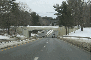
This 2002 photo shows the northbound Bethpage State Parkway at the LIRR underpass just before EXIT B4 (Central Avenue) in Bethpage. Note the underpass just to the right of the two-lane parkway for the pedestrian and bicycle trail. The parkway ends at Bethpage State Park, about one-quarter mile north of this point. (Photo by Jon Lebowitz.) |
||


|
When the Bethpage State Parkway opened in 1936, LISPC commissioner Robert Moses was considering extensions of the parkway south to Merrick Road in Massapequa, and north to the Northern State Parkway in Plainview. In the late 1950s and early 1960s, state and county officials further refined both extension proposals. |
||
|
Unlike the earlier proposed extensions, the revised extensions were to be constructed as four-lane, dual-carriageway facilities. In addition, the existing Bethpage State Parkway was to be upgraded as a modern parkway facility. |
||
|
SOUTHERN EXTENSION: Beginning at the Southern State Parkway, the Bethpage State Parkway was to have been extended two miles south through Massapequa to Merrick Road (Nassau CR 27A) in Massapequa. The right-of-way for the parkway was to have been through Massapequa State Park, so additional land acquisition was not an issue for Moses. |
||
|
Interchanges were to have been built at the following locations: |
||
|
NORTHERN EXTENSION: Beginning at the existing terminus at Bethpage State Park, the Bethpage State Parkway was to have been extended 11 miles north through Bethpage, Plainview, Woodbury, Cold Spring Harbor and Lloyd Harbor. North of the Northern State Parkway, the Bethpage State Parkway was to be designated as the Caumsett State Parkway. |
||
|
Interchanges were to have been built at the following locations: |
||

|
This 1961 map shows the proposed layout of Caumsett State Park with the northwest direction at the top of the map. Note how the proposed Caumsett State Parkway was to enter the park from the lower left-hand corner of the map, ending at a traffic circle. (Long Island State Park Commission Map provided by the Caumsett Foundation, caumsettfoundation.org.) |
||
|
EXTENSION PLANS THWARTED: Beginning in the early 1960's, Moses purchased rights-of-way for the northern extension. Residents in the wealthy enclaves of Lloyd Harbor and Cold Spring Harbor thwarted plans for both the "active use" state park and the parkway, though both remained on official plans through the 1960s and 1970s. However, without a state park as a destination, and with most of the north-south traffic needs in the area being met by the nearby Seaford-Oyster Bay Expressway (NY 135), the Bethpage State Parkway extension was not a high priority. Finally, in 1977, with Moses gone from the LISPC commissioner's post for more than a decade, Caumsett State Park opened as a "passive use" facility for hiking, biking and horseback riding. |
||
|
In 1990, the Long Island Regional Planning Board resurrected plans for extending the Bethpage State Parkway to NY 25A in Cold Spring Harbor as part of its 20-year highway improvement program. The plan did not cite potential sources for funding the extension. By 1994, this proposal appeared to be dead. Prior to the Long Island Expressway HOV project in eastern Nassau, plans submitted to the state and county by Vollmer Associates suggested that the new service roads not have any overpasses (and were eventually built without them), and no provisions were made for a future parkway at the LIE. |
||
|
THE BETHPAGE BIKEWAY: As part of its late 1970s parkway reconstruction project, the NYSDOT converted the right-of-way for the Bethpage State Parkway south of the Southern State Parkway for the initial stretch of the Bethpage Bikeway. The bikeway was extended three miles south to Merrick Road in Massapequa in the early 1980s though Massapequa State Park, which was to have served as part of the right-of-way for the Bethpage State Parkway southern extension. A bike path spur also was built from the Bethpage Bikeway to connect to the Massapequa LIRR station. |
||

|
Between 2011 and 2013, the NYSDOT built a new $6 million, six-mile extension of the Bethpage Bikeway from Bethpage State Park north to Woodbury Road in Woodbury. Most of the extended bikeway was built along the right-of-way for the Bethpage State Parkway northern extension through Old Bethpage and Plainview. Just south of the Long Island Expressway, the bikeway left the parkway right-of-way; a separated bike path was built along Washington Avenue, the LIE North Service Road, and Sunnyside Boulevard. Once the new Bethpage Bikeway reached its northern terminus at Woodbury Road, pavement markings for a new bike lane to the Syosset LIRR station were made along existing roads--Woodbury Road, Piquets Lane, South Woods Road, and Convent Road--instead of building a separate bike path. |
||


|
These 1997 photos show the overpass carrying the Long Island Expressway (I-495) over what was to be the Bethpage State Parkway in Plainview. During the HOV construction project on the Long Island Expressway, which was completed in 1999, the steelwork was removed, and the area beneath the underpass was filled in with aggregate. (Photos by Chip Ordway.) |
||

|
SOURCES: "New Highways Across Long Island To Link North and South Shores," The New York Times (11/15/1936); Master Plan for Nassau County," Nassau County Department of Public Works (1959); Arterial Progress 1959-1965, Triborough Bridge and Tunnel Authority (1965); The Power Broker by Robert A. Caro, Vintage Books-Random House (1974); History of the Long Island State Parkway System, New York State Department of Transportation (1985); "Reassessing Robert Moses: The Legacy of a Power Broker," The Newsday Magazine (12/04/1988); Robert Moses: Single-Minded Genius by Joann P. Krieg, Heart of the Lakes Publishing (1989); "LI's Roads in a Big Jam" by Tom Morris, Newsday (2/22/1990); "Extension of Three Expressways Urged" by Monte R. Young, Newsday (2/22/1990); "Ask Dr. Conehead" by Kim Nava, Newsday (6/28/1998); "Highway Hopes That Faded" by Sidney C. Schaer, Newsday (11/05/1999); "NYSDOT Peddles Its Plan for Bike Path Extension" by John Valenti, Newsday (3/25/2001); "A Guide to Our Natural World," Newsday (3/14/2004); Caumsett Foundation; New York Metropolitan Transportation Council; Vollmer Associates; Daniel T. Dey; Ralph Herman; Nathan W. Perry; Mike Tantillo; Jim Wade. |
||
|
BETHPAGE STATE PARKWAY AND CAUMSETT STATE PARKWAY LINKS: |
||

|
BETHPAGE STATE PARKWAY NYSDOT CONTRACT ARCHIVES: |
||
|
BETHPAGE STATE PARKWAY CURRENT TRAFFIC CONDITIONS: |
||
|
BETHPAGE STATE PARKWAY VIDEO LINKS: |
||

|
THE EXITS OF METRO NEW YORK: |
||

|
Back to The Roads of Metro New York home page. |
||
|
Site contents © by Eastern Roads. This is not an official site run by a government agency. Recommendations provided on this site are strictly those of the author and contributors, not of any government or corporate entity. |
||