Bookmark and Share

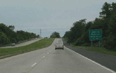
This 2004 photo shows the southbound Babylon-Northport Expressway (NY 231) approaching the exit for John Street (Suffolk CR 50) in West Islip. (Photo by Steve Anderson.)

Length:
Constructed:

2.6 miles (4.2 kilometers)
1966-1970

AN EXPRESSWAY CORRIDOR FOR WESTERN SUFFOLK: In 1957, the New York State Department of Public Works (NYSDPW) proposed a 14-mile-long, four-lane expressway between the South Shore village of Babylon and the North Shore village of Northport. The Babylon-Northport Expressway was intended to alleviate congestion on north-south arteries in western Suffolk County, particularly NY 110, Deer Park Avenue, the Robert Moses Causeway, the Sagtikos State Parkway, and the Sunken Meadow State Parkway. The original design of the expressway called for service roads only near exits and abutting neighborhoods.

The NYSDPW defined the route of the Babylon-Northport Expressway as follows:

Beginning at a point, to be determined by the commissioner of transportation, on Montauk Highway (NY 27A) in the vicinity of Higbie Lane in the Village of Babylon, thence generally northerly on new location to a point on State highway eight thousand one hundred fifty-eight (NY 25A) in the Village of Northport, as determined by the commissioner of transportation.

In its 1966 report,
Transportation 1985: A Regional Plan, the Tri-State Transportation Commission recommended construction of the Babylon-Northport Expressway as a priority project for completion by 1975. The Commission stated the purpose and benefits of the expressway as follows:

The Babylon-Northport Expressway, a north-south route for cars and commercial vehicles through western Suffolk County, fills an unserved area in the regional highway grid. It will serve as a feeder route to transportation centers on the Long Island Rail Road (LIRR) in Babylon and Deer Park.

Planning and right-of-way acquisition along the entire route of the Babylon-Northport Expressway began in 1962. The Triborough Bridge and Tunnel Authority (TBTA) estimated that the $20 million expressway would be completed by 1970. However, only a 2.6-mile section of the expressway had been completed by the end of that year.

THE ROUTE 231 STUB: The Babylon-Northport Expressway, which serves the communities of Babylon, West Islip and North Babylon, runs from Montauk Highway (NY 27A) to just south of the Southern State Parkway, with exits at John Street (Suffolk CR 50) and Sunrise Highway (NY 27). From the end of the expressway, NY 231 continues north as Deer Park Avenue, a four-lane divided arterial, to the Northern State Parkway in Dix Hills.

According to the New York State Department of Transportation (NYSDOT), the Babylon-Northport Expressway handles approximately 25,000 vehicles per day (AADT). The short highway is known locally not as the "Babylon-Northport Expressway," but as "Route 231."

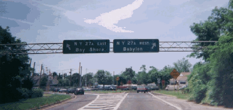
This 2000 photo shows the southern terminus of the Babylon-Northport Expressway (NY 231) at Montauk Highway (NY 27A) in Babylon. (Photo by Doug Kerr.)

HELD UP THROUGH HUNTINGTON: Throughout the 1960s, the Babylon-Northport Expressway remained as an active proposal on state, county and town maps. During these years, the New York State Department of Public Works (NYSDPW) purchased rights-of-way as far north as NY 25A for the expressway. By the end of the decade, the state had purchased more than 40 percent of the right-of-way.

North of the existing section in Babylon and West Islip, the Babylon-Northport Expressway was to continue as follows:

  • Through North Babylon, the expressway was to be routed along Samparoams Creek (Babylon-Islip town border). There was to have been a cloverleaf interchange with the Southern State Parkway.

  • In Deer Park, the expressway was to veer northwest just south of Grand Boulevard. There may have been an interchange with Long Island Avenue near the intersection of Commack Road (Suffolk CR 4).

  • Between Long Island Avenue in Deer Park and Otsego Park in Dix Hills, NY 231 was to continue along the right-of-way of Commack Road (Suffolk CR 4) and the western boundary of the former Edgewood State Hospital.

  • Through Dix Hills, the Babylon-Northport Expressway was to be routed parallel to, and about one-half mile east of Carll's Straight Path. Cloverleaf interchanges were to have been constructed with the Long Island Expressway (I-495) near the existing parking areas, and with the Northern State Parkway just east of the existing EXIT 42. Leaving Dix Hills, the expressway was to have an interchange with Jericho Turnpike (NY 25) near the intersections of East Deer Park Road (Suffolk CR 66) and Elwood Road (Suffolk CR 10).

  • Continuing north along the Greenlawn-East Northport border, NY 231 was to be routed parallel to, and about one-half mile west of Elwood Road (Suffolk CR 10). It was to cross Pulaski Road (Suffolk CR 11) just west of Stony Hollow Road; there may have been an interchange at this location.

  • For the final section in Northport, the expressway was to veer northeast to the intersection of Fort Salonga Road (NY 25A) and Elwood Road (Suffolk CR 10). There was to have been an interchange at this location.

By 1972, the cost of the expressway had risen to $50 million. Throughout the 1970s, state and county officials continued to recommend its construction between North Babylon and its proposed terminus in Northport, though officials in the Town of Huntington were less receptive. In 1981, the Tri-State Regional Planning Commission called for a downsizing of the NY 231 project as follows:

Studies should be conducted to determine if an at-grade expressway should be constructed between the Northern State Parkway and NY 25A west of Elmont Road (Suffolk CR 10), in order to relieve congestion and correct safety problems along this north-south corridor.

Under pressure from residents along the proposed route in the Town of Huntington, state officials formally killed the proposed expressway extension in 1982. The NYSDOT sold the rights-of-way for the expressway on a parcel-by-parcel basis between the late 1980s and the late 1990s.

Paul Sclichtman, frequent contributor to nycroads.com and misc.transport.road, remembered the controversy surrounding this unbuilt highway as follows:

The Babylon-Northport Expressway was most controversial to say the least. The land on the Northport terminus of the expressway is only starting to be developed. The road was supposed to end at the current intersection of NY 25A and Elwood Road (Suffolk CR 10). As a result, the land around that corner was never developed. Now there is a car wash on the old LIRR right-of-way (bitterly opposed by neighbors) and there is a self-storage building on the southeast corner. Similar development on the old right-of-way on Jericho Turnpike (NY 25) between Elwood and East Deer Park Road (Suffolk CR 66) is also new.

After the state decided it wasn't worth the trouble, the county considered building a highway (in the style of Nicolls Road / Suffolk CR 97), but they got grief as well. The Town of Huntington has been very hostile to any county highway improvements, despite the hideous congestion on roads such as Elwood Road and Pulaski Road (Suffolk CR 11).

When I was very young, the trip from the Northern State Parkway to Northport was mostly rural, only one traffic light along the way through sod and potato farms. Now when I go to Northport, I go up the Sunken Meadow State Parkway and double back.

More on the aborted section of the NY 231 expressway by Andrew Notarian:

Until 1978, my family lived at 31 Elwood Road, about a quarter mile south of NY 25A in Northport. The houses across the street from mine were purchased by the state and torn down to make room for the Babylon-Northport Expressway. I assume much of the route was planned to go along the LIRR spur that went to the original Northport railroad station (in the Village of Northport), and later on the lumber yards near there. The tracks were eventually torn up during the 1980's and the right-of-way was sold between 25A and Elwood Road to build a car wash. The lot on the corner of 25A and Elwood had industrial zoning, and there used to be a home heating oil yard with two large green tanks. Because of the industrial zoning, they were able to put up a three- or four-story public storage monstrosity. The corner across Elwood Road there is just a sump, and some new houses were built behind it over the past 20 years. This must have been the land for the interchange.

IMPROVING THE EXISTING DEER PARK AVENUE:
Under the "LITP 2000" long-range plan, the NYSDOT plans to widen the existing Deer Park Avenue from the northern terminus of the Babylon-Northport Expressway in North Babylon north to the Northern State Parkway in Dix Hills (bringing NY 231 to three travel lanes in each direction), and provide additional left-turn lanes. The proposed Long Island Rapid Commute (LIRC) articulated vehicles would utilize the third travel lane exclusively during peak periods.

THE NORTHPORT-NORWALK BRIDGE? In the mid-1960s, there were plans to extend the Babylon-Northport Expressway even further north - into Connecticut. An early cross-Sound bridge proposal called for an extension of the expressway through Asharoken and Eaton's Neck. From Eaton's Neck, a bridge would then be constructed to Norwalk, Connecticut, providing a direct connection to the US 7 Expressway and the Connecticut Turnpike (I-95). Because the area was "intensely developed with homes" and the terrain was "not conducive to highway construction," the Northport-Norwalk bridge alternative was among the first to be eliminated.

SOURCES: "State To Widen LI Road" by Ronald Maiorana, The New York Times (4/09/1962); Regional Highways: Status Report, Tri-State Transportation Commission (1962); Arterial Progress 1959-1965, Triborough Bridge and Tunnel Authority (1965); "Proposed Bayville-Rye Bridge," Nassau-Suffolk Regional Planning Board (1966); Transportation 1985: A Regional Plan, Tri-State Transportation Commission (1966); "A Comprehensive Transportation Study for Proposed Bridge Crossings," Creighton, Hamburg, Incorporated (1971); "North-South Corridor Alive Again" by Otto Erbar, The Long Islander (7/20/1972); Maintaining Mobility, Tri-State Regional Planning Commission (1981); "Lee Koppelman: The Master Planner" by Marilyn Goldstein, Newsday (8/08/1986); "Ways to Go" by Alison Mitchell, Newsday (9/21/1986); "Back to the Future: LI Updating Master Plan" by Tom Morris, Newsday (3/20/1988); "Highway Hopes That Faded" by Sidney C. Schaer, Newsday (11/05/1999); "Town, County Acquire Greenlawn Property" by Don McKay, Town of Huntington (7/01/2005); New York State Department of Transportation; Suffolk County Planning Department; Daniel T. Dey; Ralph Herman; Nick Klissas; Larry Lucchetti; Andrew Notarian; Paul Schlictman; Jim Wade.


  • NY 231 shield by Ralph Herman.

BABYLON-NORTHPORT EXPRESSWAY LINKS:

BABYLON-NORTHPORT EXPRESSWAY CURRENT TRAFFIC CONDITIONS:

BABYLON-NORTHPORT EXPRESSWAY VIDEO LINKS:

THE EXITS OF METRO NEW YORK:

  • Babylon-Northport Expressway exit list by Steve Anderson.

Back to The Roads of Metro New York home page.

Site contents © by Eastern Roads. This is not an official site run by a government agency. Recommendations provided on this site are strictly those of the author and contributors, not of any government or corporate entity.