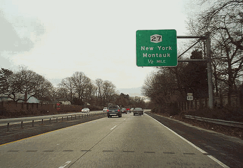
 |
 |
 |
 |
 |
 |
 |
 |
 |
 |
 |
 |
 |
 |
 |
 |
 |
 |
 |
 |
 |
 |
 |
 |
 |
|
|
|
|
|
|
|
|
|
|
|
|
|
|
|
|
|
|
|
|
|
|
|
|
|
|
 |
|
|
|
 |
|
|
|
|
|
|
|
NORTHBOUND: start at the top of the page SOUTHBOUND: start at the bottom of the page
|
|
|
|
|
|
 |
|
|
|
 |
|
|
|
|
|
|
|
|
|
 |
|
|
|
|
 |
|
 |
|
|
|
|
|
Montauk Highway (NY 27A)
WEST - Babylon, Amityville EAST - West Islip, Bay Shore
|
|
|
|
|
|
|
|
|
|
|
|
|
|
|
 |
|
|
|
|
|
|
|
|
Good Samaritan Hospital use NY 27A EAST
|
|
|
|
|
|
|
|
|
|
|
|
|
Sagtikos Manor use NY 27A EAST
|
|
|
|
|
|
|
|
|
|
|
|
|
|
|
|
(SOUTHBOUND JUNCTION ONLY)
|
|
|
|
|
|
|
|
|
|
 |
|
|
|
|
 |
|
 |
|
 |
|
|
|
|
|
|
|
|
|
|
|
 |
|
|
|
|
 |
|
|
|
|
|
John Street (CR 50)
Babylon, West Islip
|
|
|
|
|
|
|
|
|
|
|
 |
|
|
|
|
|
|
|
|
|
|
|
 |
|
|
|
|
 |
|
|
|
|
|
Sunrise Highway (NY 27)
EAST - Montauk WEST - New York
|
|
|
|
|
|
|
|
|
|
|
 |
|
|
|
|
|
|
|
|
|
|
|
|
 |
|
|
|
|
 |
|
 |
|
 |
|
|
|
|
|
|
|
|
|
|
|
 |
|
|
|
|
 |
|
|
|
|
|
Hunter Avenue
North Babylon, West Islip
|
|
|
|
|
|
|
|
|
|
|
|
|
|
|
|
 |
|
|
|
|
 |
|
|
|
|
|
|
|
|
 |
|
|
|
|
 |
|
|
|
|
|
Deer Park Avenue (CR 34)
SOUTH - North Babylon, Babylon
|
|
|
|
|
|
|
|
|
|
|
 |
|
 |
|
|
|
|
|
|
|
|
|
|
|
|
Deer Park Avenue (NY 231)
NORTH - Dix Hills, Northport, Huntington
|
|
|
|
|
|
|
|
|
|
|
|
|
|
|
|
NY 231 continues north to Dix Hills as Deer Park Avenue, a four-lane grade-level arterial. In Dix Hills, where NY 231 ends, the road splits into CR 66 (toward Northport) and CR 35 (toward Huntington).
|
|
|
|
|
|
|
|
|
 |
|
|
|
|
 |
|
|
|
|
|
|
|
|
|
|
 |
|
|
|
|
|
|
|
|
|
|
 |
|
|
|
|
|
Sign images are from the Manual of Traffic Signs by Richard C. Moeur. Additional sign images by C.C. Slater. Route shields by Ralph Herman and Jim Poserina.
Current conditions provided by metrocommute.com.
|
|
|
|
|
|
|
|
|
|
 |
|
|
|
|
|
|
|
 |
|