

|
|
||
|
This 2002 photo shows the southbound I-91 at EXIT 1 (CT 34 Expressway / Oak Street Connector) in New Haven. (Photo by Jim K. Georges.) |
||
|
Length: |
||
|
58.0 miles (93.3 kilometers) |
||

|
DESIGN AND CONSTRUCTION OF I-91 IN CONNECTICUT: In conjunction with the national highway system being developed by the Federal government, the Connecticut Highway Department proposed three major freeways in December 1944 as part of the postwar construction program. Routes on the freeway network, which eventually became I-84, I-91, and I-95, were to provide high-speed bypasses of existing US 6, US 5, and US 1, respectively. The routes were also part of the 1953 statewide system of freeways. |
||
|
Construction of what would eventually become I-91 actually commenced in 1940, four years prior to the Connecticut Highway Department study. This initial section along the Connecticut River in Hartford, originally called the "Park River Highway," opened in 1945 after three years of wartime delays and material shortages. |
||
|
LEFT: This 1963 aerial photo shows the nearly completed I-91, looking north toward the I-84 / I-91 interchange in downtown Hartford. TOP: State Highway Commissioner Howard Ives removes the barricades from the Windsor-Enfield section of I-91 in this 1959 photo. (Photos by Connecticut Highway Department.) |
||
|
HARTFORD NORTH TO ENFIELD: Work resumed northward on I-91 in 1948 beginning at State Street in downtown Hartford, continuing through the North Meadows area of Hartford, and ending at Windsor. The four-lane "North Meadows Expressway," which was originally planned in 1943 as a relocation of US 5, was opened from downtown Hartford north to EXIT 34 (Main Street) at the city line in 1950. The expressway was extended north to EXIT 38 (CT 75) in Windsor in 1956, and to EXIT 49 (US 5) in Enfield in 1959. When the last "North Meadows" section was completed, the highway was re-designated I-91. |
||
|
HARTFORD SOUTH TO MERIDEN: Construction of the "South Meadows" section of I-91 from Hartford south to New Haven began in 1960. This work included reconstruction of the original 1940s-era "Park River Highway" in Hartford to modern Interstate standards. A small, eight-to-ten lane section through downtown Hartford, from State Street south to the Charter Oak Bridge (CT 15), was completed in 1964. When it opened, this section was characterized by a number of deficiencies, including successive left-hand exits and incomplete access to I-84. (The routes that were to provide additional access, I-291 and I-484, were never completed.) |
||
|
When the 12-mile-long, six-lane Hartford-to-Meriden section of I-91 opened in October 1965, motorists were now able to travel non-stop on controlled-access highways between Washington and Boston. Before it opened, traffic from the controlled-access Wilbur Cross Parkway (CT 15) emptied out onto Berlin Turnpike, which was described in The New York Times as follows: |
||

|
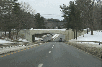
LEFT: This 1999 photo shows the northbound I-91 at EXIT 5 (US 5) in New Haven. RIGHT: This 1999 photo shows the northbound I-91 at EXIT 10 (CT 40 Expressway / Mount Carmel Connector) in North Haven. (Photos by Steve Anderson.) |
||
|
RECONSTRUCTION EFFORTS: As early as 1967, state officials realized the need to improve and add capacity to the pre-Interstate and early-Interstate era sections of I-91 from the Capital Area north to the Connecticut-Massachusetts border. Faced with projected traffic volumes of 120,000 vehicles per day by 2000, the Connecticut Department of Transportation (ConnDOT) began reconstruction efforts in the mid-to-late 1970s. The first upgrade took place from Hartford south to Wethersfield, where ConnDOT widened a six-lane section of I-91 to eight lanes. |
||

|
Around that time, ConnDOT floated plans for a $700 million reconstruction of I-91 north of Hartford. Under these plans, I-91 was to be widened to eight general-use lanes between I-84 in Hartford and the proposed I-291 in Windsor, and to six general-use lanes north to Enfield. ConnDOT also considered bus-only lanes along this stretch. In 1980, after nine years of public hearings along the route, ConnDOT decided on the following configurations for the I-91 reconstruction: |
||
|
The reconstruction of I-91 north of Hartford began in 1987, a project that included upgrading the highway to contemporary Interstate standards, adding HOV lanes, and installing noise abatement walls. During this process, 80 families (mostly in the Windsor area) were displaced. This project was completed in 1992. Throughout the 1990's, I-91 was improved expanded once again, this time from Wethersfield south to Rocky Hill. This project included widening the roadway from six to eight general-use lanes, reconstructing EXITS 25-26 (CT 3) in Wethersfield, and eliminating the unused I-291 overpasses (at what was to have been EXIT 23A) in Rocky Hill. HIGHWAY RECONSTRUCTION AND URBAN RENEWAL IN HARTFORD: The I-91 / I-84 / CT 2 interchange improvement project, also known as the "Riverfront Plaza and Founders Bridge Reconstruction Project," was envisioned as a means to revitalize downtown Hartford. The 1981 plan had three main goals:
Construction of the $115 million project began in 1987. During this project, the southbound lanes of I-91 were moved from above to below the Founders Bridge approaches to permit construction of the 1.5-acre landscaped deck (Riverfront Plaza). The landscaped deck, which spans I-91, railroad tracks and flood control walls, is a platform-supported, terraced structure that steps down to the waterfront. ConnDOT also constructed new flyover ramps to provide direct access from I-91 to I-84, taking exiting traffic off downtown streets. The new interchange was completed in 1998, and the opening of Riverfront Plaza followed two years later. The new Riverfront Plaza is expected to generate $700 million in new development, including a convention center, hotel, science center, stores and residential units. |
||


|
LEFT: This 1999 photo shows the northbound I-91 (inner roadway) and the northbound CT 15 (outer roadway) in Meriden. I-91, I-691, CT 15, and CT 66 converge at this massive interchange. RIGHT: This 2001 photo shows the northbound I-91 at EXITS 25-26 (CT 3 Expressway) in Wethersfield. This interchange was rebuilt in the early 1990s. (Photos by Steve Anderson.) |
||
|
CURRENT AND FUTURE IMPROVEMENTS: According to ConnDOT, Interstate 91 carries approximately 135,000 vehicles per day through the New Haven area, falling to approximately 80,000 vehicles per day through the Meriden area, rising back to approximately 140,000 vehicles per day through downtown Hartford, and dipping back to approximately 90,000 vehicles per day north from the North Meadows area to the Connecticut-Massachusetts border. |
||
|
In 1998, ConnDOT increased the speed limit to 65 MPH along I-91 from EXIT 8 (CT 17 and CT 80) in New Haven north to EXIT 16 (East Main Street) in Meriden, from EXIT 19 (Baldwin Avenue-Preston Avenue) in Meriden north to EXIT 25 (CT 3 Expressway) in Wethersfield, and from EXIT 35 (I-291 and CT 218) in Windsor north to the Connecticut-Massachusetts border. Other sections of I-91 are posted at 50 MPH and 55 MPH. |
||


|
LEFT: This 1999 photo shows the northbound I-91 approaching EXIT 29A (CT 598 / Whitehead Highway) in downtown Hartford. This left-hand exit was originally intended to direct traffic onto westbound I-484, which was to tunnel under the State Capitol and continue onto westbound I-84. (Photo by Steve Anderson.) RIGHT: This 1998 photo shows the southbound I-91 approaching EXIT 30 (I-84 and CT 2) in downtown Hartford. (Photo by Jim K. Georges.) |
||
|
I-91 TO LONG ISLAND? Since the late 1960s, a number of proposals have been floated for a 19.3-mile-long, four-lane Long Island Sound bridge between New Haven and Shoreham, New York. From Shoreham, I-91 would have been extended south along William Floyd Parkway (Suffolk CR 46) to at least the Long Island Expressway (I-495) in Yaphank, and perhaps as far south as Sunrise Highway (NY 27) in Shirley. |
||
|
Two approaches were considered for the Shoreham-New Haven Bridge. The first approach would have taken I-91 south along I-95 to West Haven, where I-91 would have cut a path through West Haven. The second approach would have taken I-91 along I-95 east of the Quinnipiac River to East Haven, where I-91 was to travel south through a less sparsely populated area. It was selected as the preferred approach alternative for the bridge. |
||

|
This 2006 photo shows the northbound I-91 at EXIT 35 (I-291 and CT 218) in Windsor. Originally built in the 1950s, this section was widened and rebuilt in the late 1980s and early 1990s. (Photo by Steve Anderson.) |
||

|
As part of the construction of the Shoreham-New Haven crossing, a new approach route should be constructed for I-91 along the east side of the Quinnipiac River. The new I-91 approach route would begin near EXIT 8 (CT 17 and CT 80) in New Haven, and continuing south and utilizing the Amtrak right-of-way wherever possible. A new full-cloverleaf interchange would be constructed with the Connecticut Turnpike (I-95) near EXIT 51 in East Haven. No additional interchanges would be constructed along the new I-91 south of I-95. |
||


|
SOURCES: Regional Highways: Status Report, Tri-State Transportation Commission (1962); Connecticut Highways (1959-1963), Connecticut Highway Department (1963); "New Road Pushed by Connecticut" by Richard H. Parke, The New York Times (8/07/1964); "Connecticut Gap in Route 91 Closed," The New York Times (1/07/1966); Connecticut Highway Needs, Connecticut Highway Department (1967); "Estimate of the Cost of Completing the National System of Defense Highways in Connecticut," Federal Highway Administration and Connecticut Highway Department (1968); Public Works: A Dangerous Trade by Robert Moses, McGraw-Hill (1970); A Comprehensive Transportation Study for Proposed Bridge Crossings, Creighton, Hamburg, Incorporated (December 1971); "Interstates 91 and 291, Administrative Action Final Environmental Impact Statement and Section 4(f) Statement," Federal Highway Administration and Connecticut Department of Transportation (1973); "A Bridge Link to Connecticut Could Spur Long Island's Economic Growth," Newsday (3/22/1978); Long Island Sound Bridge Study, New York State Department of Transportation (December 1979); Greater Hartford Study, Connecticut Department of Transportation (1980); "Anxiety Over Road Plans" by Deborah Gieringer, The New York Times (3/08/1981); "Interstate 91, Hartford to Enfield, Connecticut: Administrative Action Final Environmental Impact Statement and Section 4(f) Statement," Federal Highway Administration and Connecticut Department of Transportation (1981); Divided Highways by Tom Lewis, Viking-Penguin Books (1997); "To Get There from Here, Wait 20 Years" by Vivian S. Toy, The New York Times (6/25/2000); "Truck Stop and Rest Area Parking Study," Connecticut Department of Transportation (2000); "Efforts To Solve Traffic Congestion Hit Roadblocks," The Associated Press (2/20/2001); "Inventory of Comparative Decking Projects," Parsons, Brinckerhoff, Quade and Douglas (2001); "I-95 New Haven Harbor Corridor Crossing Improvement Program," Connecticut Department of Transportation (2008); Berger, Lehman Associates; Erich Bachman; Jay Hogan; Scott Oglesby; Alexander Svirsky. |
||
|
INTERSTATE 91 LINKS: |
||
|
INTERSTATE 91 (CONNECTICUT) CURRENT TRAFFIC MAPS: |
||
|
INTERSTATE 91 (CONNECTICUT) VIDEOS: |
||

|
THE EXITS OF METRO NEW YORK: |
||

|
|
||

|
Back to The Roads of Metro New York home page. |
||
|
Site contents © by Eastern Roads. This is not an official site run by a government agency. Recommendations provided on this site are strictly those of the author and contributors, not of any government or corporate entity. |
||