
|
|
||
|
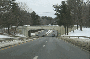
This 2017 photo shows the northbound I-395 at EXIT 13 (CT 2 Expressway) in Norwich. (Photo by Steve Anderson.) |
||
|
Length: |
||
|
54.7 miles (88.0 kilometers) |
||

|
PART OF THE ORIGINAL CONNECTICUT TURNPIKE: In 1954, the Connecticut state legislature authorized construction of the "Greenwich-Killingly Expressway," a 129-mile-long, controlled-access toll superhighway connecting the New York metropolitan area with Rhode Island. The route was to run east-northeast along Long Island Sound from Greenwich to East Lyme (the route of today's I-95), then northeast to Killingly (the route of today's I-395 and CT 695). The 1954 legislation enabled the State Highway Commission to issue construction bonds, which would be covered by tolls and other income. |
||
|
Work began on the new superhighway, now called the Connecticut Turnpike, in early 1955. Engineered for a design speed of 60 miles per hour, and a design capacity of 50,000 vehicles per day (AADT), the north-south section of the Connecticut Turnpike was constructed with four lanes between Waterford and Killingly. Like most of the pre-Interstate era turnpikes, a narrow median (topped by a steel guardrail) separated the two carriageways. |
||
|
A NEW ROUTE SERVING EASTERN CONNECTICUT: The $464 million Connecticut Turnpike opened to traffic on January 2, 1958. With the opening of the New England Thruway (I-95) in October of that year, motorists could travel nonstop all the way from the Bronx to the Connecticut-Rhode Island border. |
||
|
When the Connecticut Turnpike opened, the 93.4 miles between Greenwich and Waterford became part of I-95. (The remaining 18.2 miles of the non-turnpike section of I-95, from Waterford to Connecticut-Rhode Island border, opened to traffic in 1964.) Turning north from Waterford, the remaining 35.6 miles of the Connecticut Turnpike, which did not get a designation until the mid-1960s, eventually received a new designation: CT 52. |
||
|
Design standards on the four-lane CT 52 Expressway were similar to those on the original Connecticut Turnpike section to the south, except that a narrow, steel-guardrail barrier had been replaced with a wide, variable median. This change reflected contemporary highway design standards. |
||


|
YESTERDAY AND TODAY
LEFT: This 1963 aerial photo shows the interchange between I-395 (then known as CT 12, later known as CT 52) and US 6 in Danielson, looking east along US 6. The missing interchange movements at this cloverleaf are provided by the Killingly section of the original Connecticut Turnpike. (Photo by Connecticut Highway Department.) RIGHT: This 2000 aerial photo shows I-395 at EXIT 81 (CT 2 Expressway) in Norwich, looking northeast. (Photo by Greg Amy.) |
||
|
THE CT 52 EXPRESSWAY BECOMES I-395: In September 1983, the Connecticut Department of Transportation (ConnDOT) traded in the Interstate highway mileage for the once-proposed, but never built section of I-84 (between Bolton and the Connecticut-Rhode Island border) for the CT 52 Expressway. The new I-395 designation extended north along the entire 67-mile length of the CT 52-MA 52 Expressway from I-95 north to I-90. (North of I-90, the highway becomes I-290.) |
||
|
This was not the first attempt at Interstate status for this road. During public hearings held in 1972 and 1973, officials considered a new Interstate corridor extending north from New London, Connecticut to Manchester, New Hampshire. The proposed Interstate would have gone along the existing CT 52, I-290 and I-190 corridors north to Leominster, Massachusetts, and would have continued north along a new corridor to New Hampshire. |
||

|
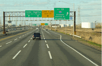
This 2017 photo shows the northbound I-395 approaching EXIT 37 (US 6 West) in Danielson. (Photo by Steve Anderson.) |
||

|
SOURCES: "Connecticut Turnpike To Be Opened to Traffic Today," The New York Times (1/02/1958); "Connecticut's 129-Mile, $464 Million Turnpike Is Opened to Traffic" by Richard H. Parke, The New York Times (1/03/1958); "Dates Set To Open New Route from the Bronx to Rhode Island" by Merrill Folsom, The New York Times (7/18/1958); Regional Highways: Status Report, Tri-State Transportation Commission (1962); Connecticut Highways (1959-1963), Connecticut Highway Department (1963); Connecticut Highway Needs, Connecticut Highway Department (1967); Planning for the Future, Connecticut Highway Department (1968); "Relocation of US 6: Administrative Action Draft Environmental Impact Statement and Section 4(f) Statement," Federal Highway Administration and Connecticut Department of Transportation (1984); "Truck Stop and Rest Area Parking Study," Connecticut Department of Transportation (2000); "A Changing Road Map: Connecticut Highways To Gradually Get New Exit Numbers" by Don Stacom, The Hartford Courant (12/07/2014); Jay Hogan; Scott Oglesby; Alexander R. Svirsky.
Connecticut Turnpike shield by James Lin. Lightposts by Millerbernd Manufacturing Company. |
||

|
INTERSTATE 395 LINKS: |
||
|
INTERSTATE 395 (CONNECTICUT) CURRENT TRAFFIC MAPS: |
||
|
INTERSTATE 395 (CONNECTICUT) VIDEO LINKS: |
||

|
THE EXITS OF METRO NEW YORK: |
||

|
|
||

|
Back to The Roads of Metro New York home page. |
||
|
Site contents © by Eastern Roads. This is not an official site run by a government agency. Recommendations provided on this site are strictly those of the author and contributors, not of any government or corporate entity. |
||