 |
|
|
|
|
|
|
|
|
|
|
|
|
|
|
|
|
|
|
|
|
|
|
|
|
|
|
|
|
|
|
|
|
|
|
|
|
|
|
|
|
|
|
|
|
|
|
|
|
|
|
|
|
|
|
|
|
|
|
|
|
|
|
|
|
|
|
|
|
|
|
|
|
|
|
|
|
|
|
 |
|
|
|
|
 |
|
 |
|
|
|
|
|
|
|
|
|
|
|
|
|
|
|
|
 |
|
|
|
|
|
|
|
|
|
|
|
|
|
|
|
 |
|
|
|
|
|
|
|
|
|
|
|
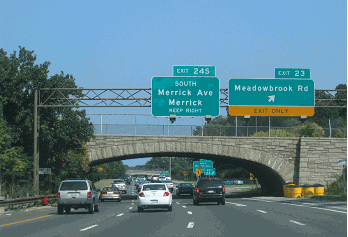
This 2004 photo shows the northbound I-287 at EXIT 21 (I-78) in Pluckermin Township. Traffic for I-78 westbound left-exits from the I-287 express lanes, while traffic for I-78 eastbound right-exits from the I-287 local lanes. (Photo by Jim K. Georges.)
|
|
|
|
|
|
|
|
|
 |
|
|
|
|
 |
|
|
|
|
|
|
|
|
|
1958-1994
67.5 miles (108.7 kilometers)
|
|
|
|
|
|
|
|
|
 |
|
|
|
|
 |
|
|
|
|
|
THE NEED FOR A NEW YORK-NEW JERSEY BELTWAY: In 1929, the Regional Plan Association (RPA) first proposed a controlled-access beltway that would encircle the New York-New Jersey metropolitan area. The proposed beltway was to be part of a network of express highways that would serve the burgeoning motor vehicle population. The circumferential route, which was to be similar in design to today's I-287, was to begin at the new Outerbridge Crossing, and was to include a new trans-Hudson crossing between Rockland and Westchester counties. It was to encircle the outer edge of suburban development and provide a bypass for interstate traffic.
|
|
|
|
|
|
|
|
|
|
|
|
|
|
|
|
|
|
|
|
|
During the early 1930s, planners proposed a controlled-access "Edison Memorial Parkway" that was to connect US 22 in Watchung with the Edison Memorial Tower in Edison, the Edison Bridge (US 9) in Keasby (Edison Township) and the Outerbridge Crossing. Borrowing from the design concepts of the early New York parkways, the Edison Memorial Parkway was to have bridle paths and scenic overlooks. The ongoing Great Depression prompted officials to shelve these plans.
Official discussions for an east-west highway in Middlesex County resumed in 1937 after initial traffic studies revealed the need for an express route between the Outerbridge Crossing, US 9, US 1 and US 22. With postwar demands taking their toll on local and regional roads, further studies for the Middlesex Freeway were undertaken when plans were revived in 1947.
In 1951, the New Jersey State Legislature passed legislation to begin route planning studies along the northern section of the route from US 22 in Somerville to NJ 17 in Mahwah. It was to be constructed as a "Relocated US 202." Two years later, the legislature passed similar legislation for the southern section of the route from US 22 in Somerville to the Outerbridge Crossing, the same section that had been advocated in 1937 and 1947 plans.
Governor Alfred E. Driscoll subsequently signed a bill authorizing construction of this southern section, but did not take action on the northern section. The 18.5-mile-long, four-lane freeway was to connect the Outerbridge Crossing with US 1, US 9, US 22, along with the new controlled-access Garden State Parkway and New Jersey Turnpike. The route, which was planned to carry 25,000 vehicles per day (AADT) by 1965, required the condemnation of 275 buildings. As an integral part of the 1955 Joint Study of Arterial Facilities headed by Robert Moses, the Middlesex Freeway was to eventually feed into the proposed (Verrazano) Narrows Bridge via the Outerbridge Crossing.
However, officials did not give up on constructing the northern section of the beltway. In 1957, representatives from New Jersey and New York revived the beltway idea by extending the route of the Middlesex Freeway north to meet the New York State Thruway mainline. The New Jersey State Highway Department lobbied the Bureau of Public Roads (BPR) to have the beltway included in the proposed Federal-aid Interstate Highway System, which at that time included neither distributors nor cross-connecting routes.
An excerpt from the 1955 state highway department study follows:
The necessity for providing highway facilities in New Jersey to serve urban population centers in New York and Pennsylvania is not limited to the provision of interstate circumferentials, but applies also to the provision of distributor or cross-connecting routes for traffic destined to various points within the central urban areas. For example, consider the fact that there are three interstate routes approaching New York City through New Jersey, and four major crossings of the Hudson River (George Washington Bridge, Lincoln Tunnel, Holland Tunnel, and proposed Narrows Bridge). Because of the great size of the area involved, it is not sufficient to connect one route to one crossing. Such a system would result in many vehicle miles of unnecessary terminal travel on local city streets.
The only proper and feasible system is to provide adequate cross-connectors so that interstate traffic approaching the area on any of the interstate routes may select either a bypass of the area, or a connection to the river crossing that will lead most nearly to the trip destination. In a reverse sense, these facilities will render the same service to traffic leaving the areas. Such a system would appear to be essential for any problem of urban area evacuation.
|
|
|
|
|
|
|
|
|
|
|
|
|
|
|
|
|
An overall system of interstate routes, including both radial distributors and belt routes, would appear to be essential from both civil defense and military bases. In an urban area of the size of New York, with an urban population in excess of 12 million spread over many square miles, any disaster would create severe congestion with a potential stoppage of all traffic. Provision of an integrated network of controlled-access highways on the Interstate system would provide a basic system that could be reserved for essential use in any time of civilian or military emergency.
|
|
|
|
|
|
|
|
|
|
|
|
|
|
|
|
|
|
In order to provide for free interchange of traffic on all interstate routes approaching New York, it is proposed to provide a "northern metropolitan area belt route" as nearly as possible around the edge of the urban development. Such a route would provide a high-speed facility for the movement of traffic bypassing the area, and would also provide a means of transferring from one route to the other. It is expected that the route proposed in New Jersey would connect with a similar route in New York at the Outerbridge Crossing and again near Suffern, and that a complete loop will be provided in the two states.
Despite the fact that the route suggested in New Jersey is many miles west of the Hudson River, studies have shown that there would be immediate traffic use by 15,000 vehicles per day, and that by 1975 this would increase so that there would be 30,000 vehicles per day on most sections, with some sections serving in excess of 30,000 vehicles per day.
For a proper functioning system, this proposed bypass or belt route is considered to have highest priority.
On April 26, 1956, New Jersey Governor Meyner and New York Governor Harriman met at Robert Moses' office at Bear Mountain State Park to coordinate and finalize plans for the Middlesex Freeway. The lobbying effort by the two states to the Federal Bureau of Public Roads (BPR) was successful, and on June 26, 1956, the 93-mile-long metropolitan beltway was added to the National System of Interstate and Defense Highways as "FAI Corridor 104." In September 1958, this circumferential highway became known as I-287.
|
|
|
|
|
|
|
|
|
|
|
|
|
|
|
|
 |
|
 |
|
|
|
|
|
|
|
|
LEFT: This 1965 photo shows an aerial view of I-287 over the Raritan River in Middlesex County. (Photo by New Jersey State Highway Department.) RIGHT: This 1970 photo, which shows the northbound I-287 approaching EXIT 14 (US 22) in Bridgewater Township, was shown in a Federally-funded study of diagrammatic signing. (Photo by New Jersey Department of Transportation.)
|
|
|
|
|
|
|
|
|
|
|
|
|
|
|
|
|
|
|
|
DESIGN AND CONSTRUCTION OF I-287: The Middlesex Freeway, now officially known as Interstate 287, was to be built to comply with Interstate standards. The four-to-eight lane freeway was to be constructed within a 300-to-400 foot right-of-way, have 50-to-100 foot medians, and have a design speed of 70 miles per hour. Wherever appropriate, there were to be collector and distributor roads to separate local and express traffic. Along its southern half, I-287 was to serve east-west traffic between the Outerbridge Crossing and I-78. From I-78 north to the New Jersey-New York border, I-287 was to serve as a north-south bypass of US 202. As originally proposed, the 62.9-mile-long I-287 in New Jersey was estimated to cost $235 million.
|
|
|
|
|
|
|
|
|
|
|
|
|
|
The general route of I-287, as excerpted from official 1967 state and 1982 Federal documents, was to be as follows:
The circumferential route begins as Route 440 in Staten Island, New York, crossing the Arthur Kill into New Jersey via the Outerbridge Crossing. It then travels westward to a junction with the New Jersey Turnpike (I-95). The I-287 designation begins at the turnpike in Edison, New Jersey. The route first proceeds west, then north, and then east, merging with I-87 at the New York state line and continuing east to its terminus at I-95 in Port Chester, New York.
In addition to the interchanges with I-95, the completed I-287 will also complete connections with the Garden State Parkway, I-78, I-80, I-87, the Palisades Interstate Parkway, I-684, and other major highways in New Jersey and New York.
In its 1966 report, Transportation 1985: A Regional Plan, the Tri-State Transportation Commission buttressed the case for completing I-287:
The proposed I-287 will complete the outer belt route around the western and northern portions of the region by tying together existing sections. It will provide a route between suburban area, including important new industrial areas.
PART OF I-287 WAS TO BE I-95: Initially, the first several miles of I-287 through Middlesex County were not to be signed as I-287, but as I-95. However, only signs for I-287 were actually posted along this section. The only evidence that I-95 was to use this section was the unnumbered exits. The unbuilt I-95 / Somerset Freeway, which was to continue south to I-295 in Ewing Township, was canceled in 1982.
William F. Yurasko, New Jersey contributor to nycroads.com, provided the following information on this section:
Since the first few miles of I-287 were really supposed to be I-95, the exits along that stretch would have been part of the exit numbering scheme of I-95, not that of I-287. Reflecting this uncertainty, the portion of I-287 that was to be EXIT 1 through EXIT 6 was never posted. Existing exits, generally posted after US 22 (current EXIT 14), were increased by four. During the mid-1990s, the exits on I-287 were re-assigned to reflect the actual I-287 terminus at the New Jersey Turnpike (I-95). For the first time, most of the exits in the first ten miles were actually posted.
EARLY CONSTRUCTION AND RESISTANCE: Construction of I-287 began in Middlesex and Somerset counties in 1958. The first sections of highway opened in the early 1960's. By 1964, a continuous route from the New Jersey Turnpike (I-95) in Metuchen northwest to I-78 and US 202 / US 206 (EXITS 21-22) in Bedminster had opened to traffic.
Further north in Morris County, stiff resistance to the route was encountered in Morristown, the site of the Morristown National Historic Park (George Washington's headquarters during the Revolutionary War). Interstate 287 was to cut a 250-foot-wide swath through the community of 18,000 residents, some of whom dressed in the uniforms of Revolutionary War soldiers to protest the freeway. Since the freeway was to traverse Federal parkland, Interior Secretary Udall tried to move it to a less disruptive alignment. In 1965, as construction crews moved into Morristown, the townspeople sat on the blades of the invading bulldozers, but this final desperate attempt failed.
Construction of I-287 progressed, with 30 miles completed as of 1967. By 1973, motorists could travel could travel on I-287 uninterrupted for 47 miles from the New Jersey Turnpike (I-95) in Metuchen north to US 202 (EXIT 44) in Montville, Morris County.
|
|
|
|
|
|
|
|
|
|
|
|
|
|
|
 |
|
|
|
|
|
|
|
|
This 2008 photo shows the southbound I-287 at EXIT 13 (NJ 28 / Union Avenue) in Bridgewater Township. (Photo by Steve Anderson.)
|
|
|
|
|
|
|
|
|
|
|
|
|
|
|
|
|
|
|
|
COMPLETING THE MISSING LINK: In 1965, communities in Morris, Passaic and Bergen counties in New Jersey, and Rockland County in New York, began their fight against the remaining 20 miles of I-287 between US 202 in Montville and the New York State Thruway (I-87) in Suffern. A number of issues, among them disruption of community services, air and noise pollution, underground well contamination, and an increased possibility of severe flooding, were raised by community and environmental groups. Siding with these groups, even the RPA argued against completing I-287 by the 1970s.
|
|
|
|
|
|
|
|
|
|
|
|
|
|
Over the next decade and a half, the New Jersey Department of Transportation (NJDOT) proposed three different alternative routes as follows:
EASTERN ALIGNMENT: Originally proposed in 1968, the eastern alignment would have continued the route of I-287 east along US 202 through Montville, Lincoln Park and Wayne. Near the intersection of US 202 and NJ 23 in Wayne, I-287 was to veer north toward Franklin Lakes and Oakland. It was to then continue northeast through the Campgaw Mountain Reservation to the Mahwah-Suffern area. Since this route would have gone through the most heavily populated areas, it was met with vociferous opposition.
WESTERN ALIGNMENT: Proposed in 1973, the western alignment would have continued the route of I-287 parallel to, and west of the Morris-Passaic CR 511 corridor through Kinnelon, Butler, Bloomingdale and Wanaque. It was to continue northeast through the Ramapo Mountains west of the Ramapo River valley, intersecting with an extended NJ 208 west of Oakland. I-287 was to meet I-87 and Route 17 in the Mahwah-Suffern area. It would have avoided heavily populated areas and parklands, but construction costs through mountainous areas were prohibitive.
CENTRAL ALIGNMENT: In 1977, a central alignment for I-287 was presented by NJDOT. I-287 was to continue northeast from the US 202 terminus in Montville to the Bloomingdale-Pompton Lakes area, where it was to intersect NJ 23 and Morris-Passaic CR 511. It was to continue northeast through Oakland, where it was to intersect and use part of the existing NJ 208 right-of-way. From this point, I-287 was to continue northeast along the eastern edges of Campgaw Mountain Reservation and Ramapo College to the Mahwah-Suffern area. Like the western alignment, the central alignment avoided the most populous areas. Construction costs were minimized by construction the highway on the edge of the Ramapo Mountains.
The expressway was to have six lanes from EXIT 47 in Montville to EXIT 59 (NJ 208) in Oakland, and four lanes from EXIT 59 to EXIT 66 (NJ 17) in Mahwah. Design capacities were established at 50,000 vehicles per day (AADT) by 1995, increasing to 75,000 vehicles per day by 2010. I-287 was to be constructed with a 50-foot-wide median, wide enough to accommodate an additional lane in each direction, and have a 300-to-400 foot right-of-way. (However, only eight of the 20 new miles had the 50-foot-wide median.) Natural and artificial barriers were designed not only to protect residents from the effects of the highway, but also to add aesthetic beauty for motorists.
Despite threats of lawsuits from 11 municipalities in the highway's path, the FHWA approved construction of the 20-mile, $1 billion "central alignment" of I-287 on September 3, 1982. This alignment added four miles to the originally allocated 62.9-mile length of I-287. Six years later, construction began with the issuance of the final permits from the Army Corps of Engineers.
On November 19, 1993, after nearly four decades of planning and construction, Governor Jim Florio opened the entire 66.9-mile length of I-287 to traffic. According to state transportation commissioner Thomas Downs, the 20-mile section of I-287 represented "the largest unopened section of interstate highway in the United States today." The entire I-287 metropolitan beltway became fully operational in August 1994, when the reconstructed EXIT 15 on the New York State Thruway was opened to traffic.
More from nycroads.com contributor William F. Yurasko as follows:
Governor Jim Florio tried to get I-287 open in time for Election Day. The Army Corps of Engineers delayed the opening to conduct drainage tests and Florio lost the election. There used to be quite a few "Impeach Florio" bumper stickers attached to guide signs on I-287, but I think most are gone now. Anyway, it opened a little more than two weeks after Election Day, on a Friday. The next day, I was on it with my family on the way to Yale Bowl in New Haven for the Yale-Harvard game. Needless to say, it was good timing. The road was all concrete and very impressive. Some possibly spectacular views were eliminated though, since wire baskets full of rock were used as walls obscuring any such view. My dad and I can never for the life of us remember what that is called, only that it is a French word.
|
|
|
|
|
|
|
|
|
|
|
|
|
|
|
 |
|
|
|
|
|
|
|
|
This 2004 photo shows the northbound I-287 approaching EXIT 36 (Morris CR 510 / Morris Avenue) in Morristown. Shown just before the exit is the viaduct carrying the NJ Transit-Morristown (Morris and Essex) Line over I-287. (Photo by Jim K. Georges.)
|
|
|
|
|
|
|
|
|
|
|
|
|
|
|
|
|
|
|
|
|
|
|
|
|
|
|
|
|
|
BELTWAY AND BYPASS: The opening of I-287, while increasing inter-regional traffic around New York City, has reduced congestion on local roads. Through traffic from upstate New York and New England to Pennsylvania can use I-287 as a shortcut to I-80 and I-78. Similarly, motorists on I-95 from the Middle Atlantic states can travel on I-287 to access I-87 and other intersecting routes, thereby avoiding metropolitan area traffic.
|
|
|
|
|
|
|
|
|
|
|
|
|
|
Perhaps most importantly, interstate trucks can use the route to bypass congested expressways in New York City. Jeffrey Zupan, transportation consultant to the RPA, said the following about I-287:
It was needed because it makes the movement of goods around the region easier. If it is difficult and expensive to move things from one place to another, if every truck headed to New England has to go through the Bronx, then the region is not going to stay competitive.
Many community leaders have praised the completion of I-287 for the new tax revenue coming from increased development. In the year after I-287 opened, some $75 million worth of new housing, retail and office buildings construction took place along the route. However, some fear that I-287 would spur development in the environmentally sensitive Ramapo Mountains.
ROADWAY LAYOUTS AND TRAFFIC COUNTS: The different sections of I-287 are described as follows:
I-95 / New Jersey Turnpike (southern terminus) in Edison to EXIT 14 (US 22) in Bridgewater: This section has eight lanes (4-4) from I-95 to EXIT 2 (NJ 27), six lanes (3-3) from EXIT 2 to EXIT 13 (NJ 28), and eight lanes (4-4) from EXIT 13 to EXIT 14 (US 22). While this section is the second-most traveled on I-287 - it carries approximately 100,000 vehicles per day (AADT) - it is the only section not to have been widened since it was built back in the early 1960s. (The proposed I-95 / I-695 project would have widened I-287 to eight lanes from the New Jersey Turnpike to the unbuilt I-95 interchange in Piscataway. In preparation for this project, I-95 was "secretly" designated on I-287 between milepost 0.0 and milepost 5.7 from 1966 until 1982; the I-95 designation went as far north as milepost 9.6 until 1973. According to nycroads.com contributor Raymond C. Martin, the I-95 designation - not the I-287 designation - would have applied on this section had the unbuilt Somerset Freeway been constructed.) The speed limit on this section is 65 MPH.
EXIT 14 to EXIT 17 (US 202-US 206) in Bridgewater: This section, which carries approximately 80,000 vehicles per day, was originally built as a four lane (2-2) section in the early 1960s, and widened to six lanes (3-3) in the mid-1990's. The speed limit on this section is 65 MPH.
EXIT 17 to EXIT 21 (I-78) in Bedminster: This section, which carries approximately 80,000 vehicles per day, was originally built as an eight-lane (2-2-2-2) section in the early 1960s, and widened to its present 11-lane (3-3-3-2) configuration in the mid-1990s. The northbound outer roadway is used for I-78 eastbound traffic, while the northbound inner roadway is used for I-78 westbound traffic. (Through traffic could use either northbound roadway.) The southbound outer roadway comes from I-78 westbound and leads to right-hand EXIT 17 (US 202-US 206). The southbound inner roadway comes from I-78 eastbound and leads to left-hand EXIT 17. The speed limit on this section is 65 MPH.
EXIT 21 to EXIT 37 (NJ 24 Freeway) in Morristown: This section, which carries approximately 70,000 vehicles per day, has nine lanes (4 southbound-5 northbound) immediately north of I-78 to EXIT 22 (US 202 / US 206), then narrows to six lanes (3-3) from north of EXIT 22 to EXIT 33 (Harter Road). The roadway then widens to eight lanes (4-4) from EXIT 33 to EXIT 37. From when the highway opened in the mid-to-late 1960s, until the HOV lane project in the mid-1990s, this part was seven lanes (3 southbound-4 northbound), then four lanes (2-2), then six lanes (3-3), over the same sections. The speed limit on this section is 65 MPH.
EXIT 37 to EXIT 41 (I-80 and US 46) in Parsippany-Troy Hills: This section, which carries approximately 110,000 vehicles per day, has ten lanes (5-5) from EXIT 37 to EXIT 39 (NJ 10), then 11 lanes (4 southbound outer-2 southbound inner-5 northbound) from EXIT 39 to EXIT 41 (I-80 and US 46). When this section was constructed in the mid-to-late 1960's, it was eight lanes (4-4) from EXIT 37 (which opened in 1992) to EXIT 39, then eight lanes (4-4) from EXIT 39 to EXIT 41. The present configuration dates from the HOV lane project in the mid-1990s. The southbound side got a "Jersey wall"-separated inner roadway, which was originally intended to be a HOV lane-to-HOV lane flyover ramp. These inner lanes on the southbound side come from I-80 west, and there is no access from these inner lanes to EXIT 40 (Morris CR 511) southbound. The speed limit on this section is 55 MPH.
EXIT 41 to EXIT 52 (NJ 23) in Pompton Plains: This section, which carries approximately 55,000 vehicles per day, has eight lanes (4-4) from EXIT 41 to EXIT 42 (US 46-US 202), then six lanes (3-3) from EXIT 42 to EXIT 52. The sub-section from EXIT 41 north to EXIT 47 (US 202) has not been widened since it opened in the late 1960s. The six-lane sub-section north of EXIT 47 opened in 1993. The speed limit on this section is 65 MPH.
EXIT 52 to EXIT 59 (NJ 208) in Franklin Lakes: This six-lane (3-3) section carries approximately 70,000 vehicles per day. In 1990, the first sub-section - a one-mile-long bypass of Pompton Plains - opened between EXIT 52 and EXIT 53 (Morris CR 694 and Morris CR 511A). Three years later, the remainder of the section opened north to EXIT 59. (This sub-section included a reconstructed western terminus of NJ 208, which was originally constructed in the early 1960s). In the late 1990's, several years after this section opened, a new EXIT 55 (Passaic CR 511 and Passaic CR 511A) opened in Wanaque Borough. The speed limit on this section is 65 MPH.
EXIT 59 to New York State Thruway (I-87 / I-287) in Suffern: This section carries approximately 50,000 vehicles per day. The four-lane (2-2) sub-section from EXIT 59 to EXIT 66 (NJ 17) opened in 1993, and the six-lane (3-3) I-287 / NJ 17 connector to the New York State Thruway opened in 1994. The speed limit is 65 MPH on the four-lane sub-section, dropping to 55 MPH on the connector.
|
|
|
|
|
|
|
|
|
|
|
|
|
|
|
 |
|
|
|
|
|
|
|
|
This 2004 photo shows the northbound I-287 at EXIT 40 (Morris CR 511 / Parsippany Road) in Parsippany-Troy Hills Township. (Photo by Jim K. Georges.)
|
|
|
|
|
|
|
|
|
|
|
|
|
|
 |
|
|
|
|
|
THE RISE AND FALL OF THE HOV LANES: In 1994, construction crews were not finished with I-287. Beginning that year, and lasting through January 1998, crews built 20.2 miles of northbound and southbound HOV lanes in the center median of I-287 between EXIT 22 (US 202 and US 206) in Bedminster and EXIT 41 (I-80) in Parsippany-Troy Hills. The lanes, which were opened to vehicles with two or more occupants during rush-hour periods, and to all vehicles during non-rush periods, cost $200 million to construct.
|
|
|
|
|
|
|
|
|
|
|
|
|
|
Along the stretch under HOV lane construction, existing mainline sections were widened and improved. Provisions were to be made for proposed (but never constructed) HOV lane-to-HOV lane flyover exit ramps between I-287 and I-80 in Parsippany.
Further south, from Bridgewater southeast to Metuchen, minor modifications were made to I-287. New pavement, signs and safety improvements were made to the existing roadway. Moreover, for the first time, exits followed a logical, milepost-based numbering scheme from Metuchen north to Mahwah.
The new HOV lanes were not met with great fanfare. While traffic continued to build on the general-use lanes, the HOV lanes often went unused. This reflected of variety of factors: lower fuel prices, decentralized suburban development, two-career families and multi-stop commuting. Since the HOV lanes were planned in the early 1980's, carpool usage had plummeted from 18 percent to 8 percent by the mid-1990's. Spurred by angry commuters, local politicians soon demanded the removal of the HOV lanes.
Using the following national criteria established by the FHWA, the NJDOT undertook studies to analyze the effectiveness of the I-287 HOV lanes:
Do the HOV lanes encourage carpooling?
Do the HOV lanes carry 700 vehicles per hour for usage, while carrying as many people in the HOV lanes as the average of the general purpose lanes?
Do the HOV lanes reduce the current level of congestion and air pollution?
The NJDOT determined that the I-287 HOV lanes failed on two out of these three criteria. Soon thereafter, Governor Christine Whitman announced the elimination of the HOV lanes:
After careful analysis of the situation, New Jersey has concluded that the lanes do not succeed in alleviating traffic congestion or improving air quality, and that their removal is warranted. Accordingly, the state intends to terminate their operation on Monday, November 30, 1998. We have taken a long, hard look at New Jersey's HOV lanes and concluded that they simply are not producing the results that we all had hoped for.
The HOV lanes were converted into general-use lanes. Since the NJDOT found that the HOV lanes did not meet the national criteria for effectiveness, U.S. Transportation Secretary Rodney Slater waived the $200 million cost, most of which came from Federal funds, of the I-287 HOV lanes.
|
|
|
|
|
|
|
|
|
|
|
|
|
|
|
 |
|
|
|
|
|
|
|
|
This 2007 photo shows the southbound I-287 at EXIT 55 (Passaic CR 511 / Union Avenue and Passaic CR 511A / Ringwood Avenue) in Wanaque Borough. (Photo by Steve Anderson.)
|
|
|
|
|
|
|
|
|
|
|
|
|
|
|
|
|
|
|
|
CURRENT AND FUTURE IMPROVEMENTS: From south to north, the NJDOT has built or planned the following improvements on I-287:
The NJDOT plans to repave six miles of I-287 from the New Jersey Turnpike (I-95) in Edison north to EXIT 6 (Middlesex CR 665 / Washington Avenue) in Piscataway during 2007 and 2008. The project is estimated to cost $16 million.
|
|
|
|
|
|
|
|
|
|
|
|
|
|
The NJDOT has long-range plans to rebuild the I-287 bridge over the Raritan River in South Bound Brook. Approaches also may be rebuilt between EXIT 9 (Middlesex CR 514 / River Road) and EXIT 10 (Somerset CR 527 / Easton Avenue).
Between EXIT 17 (US 202-US 206) in Bridgewater Township and EXIT 22 (US 202-US 206) in Bedminster Township, the NJDOT is planning a major reconstruction project. The NJDOT will rebuild EXIT 21 (I-78) in Pluckermin Township, and add missing movements to and from nearby US 202-US 206. The new ramps will be designed such as not to require further land takings. In addition, the NJDOT will widen US 202-US 206 from two to four lanes in the area of the interchange. Major reconstruction work is not scheduled to begin until after 2010.
The NJDOT plans to mill and resurface five miles of I-287 from EXIT 30 (Maple Avenue) in Basking Ridge to EXIT 35 (NJ 124 / Madison Avenue) in Morristown. The $6.2 million project is slated for completion in 2007.
At EXIT 37 in Morristown, the NJDOT widened the existing one-lane ramp connecting southbound I-287 to the eastbound NJ 24 Freeway to two lanes. The $4 million project, which required widening the NJ 24 overpass over I-287, was completed in late 2003.
Just north of EXIT 39 (NJ 10) in Hanover Township, the NJDOT planned an overpass over I-287 to connect Ridgedale Avenue with Eastmans Road. The $14 million project was designed to improve circulation between Hanover and Parsippany. However, local concerns about potential impacts on a nearby residential development and a wetlands area shelved the project indefinitely.
The NJDOT will repave six miles of I-287 from EXIT 41 (I-80) north to EXIT 47 (US 202) in Montville during 2006 and 2007. However, reconstruction of the ramps between I-287 and I-80 likely will wait until at least 2009. The $75 million interchange reconstruction project, which would include pavement rehabilitation of the I-80 mainline, replacement of bridge decks, and extension of acceleration-deceleration lanes, likely would continue through at least 2012.
The NJDOT rehabilitated the pavement of the mainline I-287 from EXIT 47 (US 202) in Montville north to EXIT 59 (NJ 208) in Franklin Lakes. Part of the final section of I-287 to be constructed, this stretch section was built with a grooved pavement designed to improve drainage and traction. However, residents complained about the noise generated from trucks passing over the grooved pavement. The $12 million project was completed in 2002.
Major improvements are planned for the area of EXIT 66 (NJ 17) in Mahwah, where the NJDOT will construct a new truck weigh station, parking area and maintenance facility along the southbound lanes of I-287. The $41 million project, which includes lengthening the acceleration-deceleration lanes on I-287, widening the I-287 bridge over the Ramapo River, and improving the nearby intersection between NJ 17 and Stag Hill Road, originally was scheduled for completion by 2006, but has been delayed.
DO YOU BELIEVE IN MAGIC? In 2000, the NJDOT activated the $45 million "MAGIC" intelligent transportation system along I-287 and other North Jersey roadways. The "MAGIC" system, which stands for Metropolitan Area Guidance Information and Control, uses radar, pavement sensors, electronic message signs, fiber-optic cable and closed circuit cameras to alert drivers to traffic accidents or weather hazards, and to post the best alternate routes.
|
|
|
|
|
|
|
|
|
|
|
|
|
|
|
 |
|
|
|
|
|
|
|
|
This 2004 photo shows the northbound I-287 approaching EXIT 66 (NJ 17) and the New York State border in Mahwah. (Photo by Jim K. Georges.)
|
|
|
|
|
|
|
|
|
|
|
|
|
|
 |
|
|
|
|
|
To meet current and anticipated demand on I-287, the existing six-lane section from EXIT 2 (NJ 27) north to EXIT 13 (NJ 28) should be widened to at least eight lanes, and the existing four-lane section from EXIT 59 (NJ 208) north to EXIT 66 (NJ 17) should be widened to at least six lanes.
Chris Blaney, New Jersey contributor to nycroads.com, provided the following recommendation for widening the southern section of I-287:
|
|
|
|
|
|
|
|
|
|
|
|
|
|
The most heavily traveled section of highway, from EXIT 14 (US 22) south to the New Jersey Turnpike (I-95), has not been widened since it was opened. This should be corrected by adding a reversible two-lane center roadway from EXIT 17 (US 202-US 206) to the New Jersey Turnpike.
The new reversible roadway would not be set aside for HOV use when it opens. Instead, the roadway would be opened only to passenger cars equipped with EZ-Pass (like the Gowanus Expressway HOV lane) and for starters, charge no toll. It would be used for southbound traffic in the morning rush, and used for northbound traffic in the evening rush. The EZ-Pass would only be for traffic control (vehicles on this roadway without an EZ-Pass tag would get fined and two points).
Once completed, the roadway would be an eight-lane (3-2-3) configuration through much of the area, and a ten-lane configuration (4-2-4) in the area of EXIT 14. I-287 would then provide five lanes of southbound traffic in the morning rush, and five lanes of northbound traffic in the evening rush. The reversible "express" roadway, which would have a speed limit of 65 MPH (as opposed to 60 MPH in the outer lanes), would only have crossover ramps near major interchanges.
|
|
|
|
|
|
|
|
|
 |
|
|
|
|
|
|
|
|
|
 |
|
|
|
 |
|
|
|
|
|
SOURCES: Joint Study of Arterial Facilities, The Port of New York Authority and the Triborough Bridge and Tunnel Authority (1955); "Middlesex Freeway," New Jersey State Highway Department (1956); "New Roads with New Numbers Will Parallel Old U.S. Routes" by George Cable Wright, The New York Times (9/19/1958); "Savings of $31,000 Yields $25 Million" by George Cable Wright, The New York Times (9/09/1960); Regional Highways: Status Report, Tri-State Transportation Commission (1962); Transportation 1985: A Regional Plan, Tri-State Transportation Commission (1966); New Jersey Highway Facts, New Jersey Department of Transportation (1967); Road to Ruin by A.Q. Mowbray, J.B. Lippincott Company (1969); "Route I-287: Change Unlikely" by Michael Monroe, The New York Times (6/17/1973); "New Route Proposed for I-287 Extension" by Robert Hanley, The New York Times (10/04/1977); "Interstate Route 287: Technical Study for the Preferred Alternative," Federal Highway Administration and New Jersey Department of Transportation (1978); "Interstate 95," Delaware Valley Regional Planning Commission (1978); "Interstates 95 and 695: Administrative Action Draft Environmental Impact Statement and Section 4(f) Statement," Federal Highway Administration and New Jersey Department of Transportation (1979); "Interstate 287," New Jersey Department of Transportation (1981); "Interstate Route 287, Administrative Action Final Environmental Impact Statement and Section 4(f) Statement," Federal Highway Administration and New Jersey Department of Transportation (1981); "U.S. Approves Jersey Link to Thruway," The New York Times (9/04/1982); "Missing Link of Interstate Opens, Despite Lawsuit," The New York Times (11/20/1993); Divided Highways by Tom Lewis, Viking-Penguin Books (1997); "Highway HOV Lanes Seem To Be an Idea Whose Time Has Passed" by Daniel Machalaba, The Wall Street Journal (8/27/1998); "Are HOV Lanes Helping Ease Traffic?" by George Lewis, NBC News (12/01/1998); "Repaving Set for Noisy Part of I-287" by Doug Most, The Bergen Record (4/27/2000); "DOT's Electronic Signs Finally Get Their Smarts" by Pat R. Gilbert, The Bergen Record (6/22/2000); "Route 287 Connection Opposed" by Darran Simon, The Daily Record (8/04/2001); "DiFrancesco Backs Plan To Expand 65 MPH Speed Limit," The Associated Press (8/15/2001); "Long and Winding Road to Improving I-287" by Rob Jennings, The Daily Record (3/12/2006); North Jersey Transportation Planning Authority; George Alexander; Chris Blaney; Phil Case; Frank Curcio; Rich Dean; Keith Dennison; Ralph Herman; Michael G. Koerner; George Kowal; Arthur Malkin, Raymond C. Martin; Christopher G. Mason; Dan Moraseski; Jim Padykula; Michael Romero; Gerard Trabalka; William F. Yurasko.
I-287 shield by Ralph Herman.
Lightposts by Millerbernd Manufacturing Company.
HOV sign by C.C. Slater.
|
|
|
|
|
|
|
|
|
|
|
|
|
|
|
|
 |
|
|
|
|
|
|
|
|
|
|
|
|
|
|
|
|
|
|
|
 |
|
|
|
|
|
|
|
|
|
 |
|
|
|
|
|
THE EXITS OF METRO NEW YORK:
I-287 (New Jersey) exit list by Steve Anderson.
|
|
|
|
|
|
|
|
|
|
|
 |
|
|
|
|
|
|
|
|
 |
|
|
|
|
|
|
|
|
|
|
|
|
Site contents © by Eastern Roads. This is not an official site run by a government agency. Recommendations provided on this site are strictly those of the author and contributors, not of any government or corporate entity.
|
|
|
|
|
|
|
|
|
 |
|