
|
|
||
|
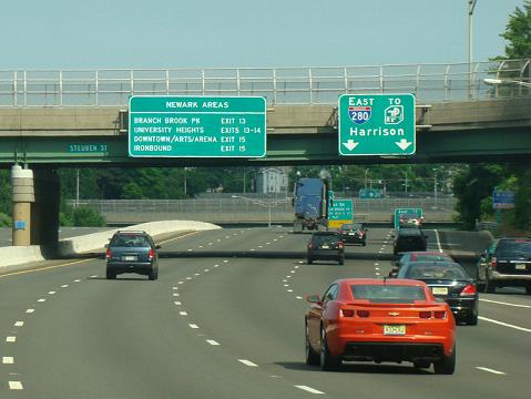
This 2014 photo shows the eastbound I-280 approaching EXIT 13 (First Street) in Newark. The depressed roadway alternative resulted from intense community opposition to the original elevated highway alternative. The bridges over I-280 were constructed several years before the roadway was completed. The multi-lane left exit for EXIT 13 was to have been used for the unbuilt NJ 75 Freeway. (Photo by David Golub, www.eastcoastroads.com.) |
||
|
Length: |
||
|
17.9 miles (28.7 kilometers) |
||

|
AN EARLY EXPRESSWAY TO THE STICKEL BRIDGE: Interstate 280, originally known as the Essex Freeway, had its beginnings as NJ 25A, a 1.1-mile-long highway connecting Clifton Avenue in downtown Newark with Grant Avenue in Harrison. In 1949, the William J. Stickel Memorial Bridge, a four-lane span carrying NJ 25A over the Passaic River, was opened to traffic. Named after a one-time Essex County engineer, the 125-foot-long vertical span has a vertical clearance of 35 feet over mean high water. |
||
|
The same year that the Stickel Bridge opened, the New Jersey State Highway Department proposed the Essex Freeway, an east-west road stretching from the proposed New Jersey Turnpike in Hudson County to US 46 in Morris County. In 1954, one year after the highway was re-christened NJ 58, an approach stretching one-half to the west of the lift span was opened to traffic. These initial sections of NJ 58 formed part of the new Essex Freeway, which was to continue west through Newark into the area of Parsippany. Most of the new route was to parallel NJ 10, a congested, two-lane radial route. |
||
|
To hold down construction costs, the state commissioned the engineering firm S.J. Groves and Sons to construct a temporary railroad along the I-280 right-of-way. Engineers first cut through First Mountain, and had approximately 1.5 million cubic yards of rock ready to haul to a replacement fill toward the western end of I-280, where a separate section was being graded over unstable land. However, after determining that the gravel on the completed section of roadbed was too hard on oversized truck tires (not to mention the grades that the trucks had to negotiate), engineers decided to construct a temporary railroad to haul the rock fill west along the route of I-280. The temporary railroad stretched approximately seven miles from West Orange to the I-80 interchange in Parsippany. |
||
|
CONSTRUCTION TIMELINE: In 1960, construction of I-280 began in the Orange-West Orange area. Between 1966 and 1973, 14.5 miles of the route from Parsippany east to Harrison were opened to traffic, leaving 3.4 miles of I-280 remaining unbuilt. In Newark, an unfinished interchange - EXIT 13 - was constructed to accommodate the unbuilt NJ 75 (Newark Midtown) Freeway. |
||
|
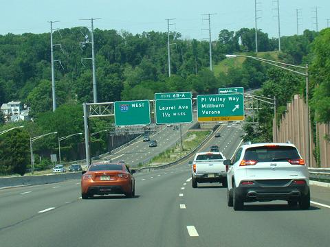
This 2016 photo shows the westbound I-280 approaching EXIT 7 (Pleasant Valley Way) in West Orange. During the design stage in the late 1950s, state highway officials decided upon a longer, less costly route for I-280 rather than constructing a vehicular land tunnel through First Mountain. The power line poles shown in this photo replaced older steel lattice towers in the mid-2010s.(Photo by David Golub, www.eastcoastroads.com.) |
||
|
ROADWAY LAYOUT AND TRAFFIC COUNTS: The different sections along I-280 are described as follows: |
||
|
MUCH-NEEDED REHAB FOR THE STICKEL BRIDGE: Some years ago, the NJDOT considered replacing the existing four-lane Stickel Bridge with a six-lane vertical lift bridge. The I-280 proposal was part of a never-implemented NJDOT master plan to rebuild the New Jersey Transit-Broad Street Station and provide a separate new vertical lift span for the old Delaware, Lackawanna, and Western (DL&W) Railroad swing bridge. In mid-1998, officials from the NJDOT asked the U.S. Coast Guard to change the operating rules for the Stickel Bridge. The NJDOT proposal would close the bridge permanently to navigation, which allows for closure of a moveable bridge due to infrequent use. The April 2001 release of a NJDOT report labeling the Stickel Bridge "structurally deficient and functionally obsolete" has prompted officials to consider options to either rehabilitate or replace the bridge. Inspectors found both the superstructure and substructure of the old span to be in "poor" condition, the result of wall cracks and severe corrosion of structural steel. Furthermore, the steel-grated roadway, narrow lanes and tight ramps leading to the local streets have contributed to the bridge's high accident rate. As an interim measure, the NJDOT has reduced the speed limit on the bridge to 40 MPH. The need to replace the bridge and approach roadways took on greater significance during three incidents during 2001. First, chunks of concrete from the elevated I-280 fell down onto the intersection of State Street and University Avenue in downtown Newark. The addition of new concrete supports between the bridge and EXIT 15 (NJ 21) may have weakened other parts of the road in the area, causing what the NJDOT called "a hole in the deck." Second, an expansion joint fell out from the main deck of the Stickle Bridge into the Passaic River. More recently, a small section of the bridge deck itself fell into the Passaic River. During the "conceptual development" phase, the NJDOT proposed the following alternatives for either rehabilitating or replacing the span, and upgrading the approach roadways:
In early 2005, the NJDOT decided on the "rehabilitation" option under the state's "hyperbuild" initiative designed to cut costs and save construction time. Construction of the $42 million project began in 2006 and was completed in 2009. |
||
|
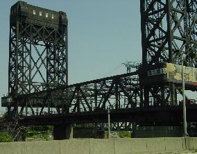
These 2002 photos show the Stickel Bridge over the Passaic River. Built in 1949, the four-lane bridge is structurally deficient and functionally obsolete. The NJDOT dropped plans to replace the span, and instead rehabilitated the bridge. (Photos by Jim K. Georges.) |
||
|
OTHER IMPROVEMENTS ON I-280: In 2000, the NJDOT completed a long-delayed reconstruction project at EXIT 1 (Morris CR 632 / New Road). Previously a partial interchange diamond interchange, the rebuilt EXIT 1 received a new eastbound off-ramp and a new westbound on-ramp. In addition, the existing westbound off-ramp and eastbound on-ramp were replaced with new ramps. |
||
|
In 2006, the NJDOT replaced the eastbound bridge over the Morristown-Erie Railroad just east of EXIT 4 (Essex CR 609 / Eisenhower Parkway). The $4 million project took only three weeks using a "hyperbuild" design strategy. The project contractors built the deck panels off-site and transported them to the bridge to install. A more traditional strategy of building the deck on-site would have taken up to nine months to complete. |
||
|
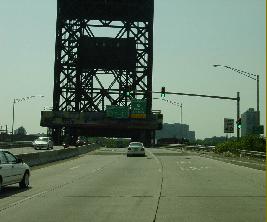
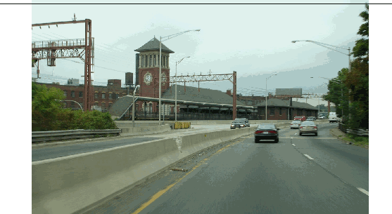
This 2005 photo shows the westbound I-280 just west of the Stickel Bridge. The four-lane section of I-280 shown here was built during the early 1950s as NJ 58. Shown on the left is the NJ Transit-Broad Street Station. (Photo by Jim K. Georges.) |
||

|
I-280 EAST TO THE HOLLAND TUNNEL? The original 1957 proposal for I-280 submitted by the New Jersey State Highway Department included an extension east of I-95 to the Holland Tunnel approach (I-78) in Jersey City. This route, which was to parallel NJ 7 (Newark Pike) and Hudson CR 508 (Harrison Avenue) through Kearny and Jersey City, was to run through the ecologically sensitive New Jersey Meadowlands, near the confluence of the Hackensack and Passaic rivers. |
||

|
SOURCES: "Report on East-West and Route 10 Freeways and Connections," New Jersey State Highway Department (1948), "FAI 105 Interstate Highway Corridor: Recommendation Report," New Jersey State Highway Department (1957); "New Roads with New Numbers Will Parallel Old U.S. Routes" by George Cable Wright, The New York Times (9/19/1958); "Depressed Road Backed in Essex" by Milton Honig, The New York Times (4/01/1959); "Public Hearing on the Depression of Essex Freeway," New Jersey State Assembly (3/29/1961); "Newark Transportation Study," New Jersey State Highway Department (1961); Regional Highways: Status Report, Tri-State Transportation Commission (1962); Transportation 1985: A Regional Plan, Tri-State Transportation Commission (1966); "Interstate Route 280: Stickel Bridge to I-95," New Jersey Department of Transportation (1967); New Jersey Highway Facts, New Jersey Department of Transportation (1967); Maintaining Mobility, Tri-State Regional Planning Commission (1975); "S.J. Groves and Sons," Extra 2200 South (November 2000); "State Looks To Fix the Stickel" by Guy Sterling, The Star-Ledger (4/20/2001); "Elevated Route 280 Section Drops Chunks on Newark" by Guy Sterling, The Star-Ledger (5/02/2001); "DiFrancesco Backs Plan To Expand 65 MPH Speed Limit," The Associated Press (8/15/2001); "Parkway Upgrades Traveling in Fast Lane" by Daniel Sforza, The Bergen Record (12/19/2004); "State Scales Back Plans for Bridge" by Joe Malinconico, The Star-Ledger (3/17/2005); "I-280 / Route 21 Interchange Improvements," Engineering News-Record (9/24/2019); "I-280 / Route 21 Interchange Improvements," Roads and Bridges (10/04/2019); North Jersey Transportation Planning Authority; Chris Blaney; Frank Curcio; Yuri Dieujuste; Hank Eisenstein; Bill Guimes; Tim Hester; Michael G. Koerner; George Kowal; Arthur Malkin; Raymond C. Martin; Christopher G. Mason; Dan Moraseski; Scott Oglesby; William F. Yurasko. |
||

|
INTERSTATE 280 LINKS: |
||
|
INTERSTATE 280 (NEW JERSEY) CURRENT TRAFFIC MAPS: |
||
|
INTERSTATE 280 (NEW JERSEY) VIDEO LINKS: |
||

|
THE EXITS OF METRO NEW YORK: |
||

|
|
||

|
Back to The Roads of Metro New York home page. |
||
|
Site contents © by Eastern Roads. This is not an official site run by a government agency. Recommendations provided on this site are strictly those of the author and contributors, not of any government or corporate entity. |
||