 |
|
|
|
|
|
|
|
|
|
|
|
|
|
|
|
|
|
|
|
|
|
|
|
|
|
|
|
|
|
|
|
|
|
|
|
|
|
|
|
|
|
|
|
|
|
|
|
|
|
|
|
|
|
|
|
|
|
|
|
|
|
|
|
|
|
|
|
|
|
|
|
|
|
|
|
|
|
|
|
|
|
|
|
|
|
|
|
|
|
|
|
|
|
|
|
|
|
|
|
|
|
|
|
|
|
|
|
|
 |
|
|
|
|
 |
|
 |
|
|
|
|
|
|
|
|
|
|
|
|
|
|
|
|
 |
|
|
|
|
|
|
|
 |
|
|
|
|
|
|
|
|
|
|
|
|
|
|
|
|
|
|
|
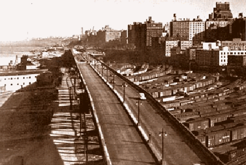
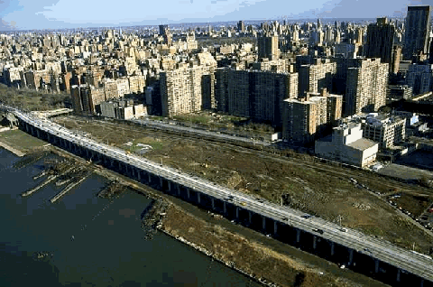
The West Side Highway (circa 1936) over the West Side Railroad Yard between 59th and 72nd Streets, looking north. Reconstruction is underway on this last remaining section of elevated highway. (Photo by New York City Municipal Archives.)
|
|
|
|
|
|
|
|
|
 |
|
|
|
|
 |
|
|
|
|
|
|
|
|
|
5.7 miles (9.2 kilometers)
1927-1948 (original elevated highway)
1995-2001 (reconstructed surface arterial)
|
|
|
|
|
|
|
|
|
 |
|
|
|
|
|
|
|
|
Tolls are not charged for the West Side Highway itself.
CONGESTION PRICING: Motorists exiting from the West Side Highway onto streets in Lower Manhattan are subject to the following congestion pricing fees (via EZ-Pass). There is a surcharge for bill-by-plate.
|
|
|
|
|
|
|
|
|
|
|
|
|
|
5:00am-9:00pm Monday through Friday
9:00am-9:00pm Saturday and Sunday
|
|
|
|
|
|
|
|
|
|
|
|
|
|
|
9:00pm-5:00am Monday through Friday
9:00pm-9:00am Saturday and Sunday
|
|
|
|
|
|
|
|
|
|
|
|
|
|
 |
|
|
|
|
|
THE ORIGINAL WEST SIDE HIGHWAY: For nearly five decades, the line of demarcation between the Hudson River shoreline and the interior of Manhattan was the elevated structure of the West Side Highway. The West Side Highway, originally designated NY 9A north of the Holland Tunnel and NY 27A south of the Holland Tunnel, was part of a limited-access, automobile-only system of parkways conceived by New York's master planner, Robert Moses. The original elevated highway from West 72nd Street south to Chambers Street was constructed between 1927 and 1931. It was extended south from Chambers Street to the Brooklyn-Battery Tunnel approach between 1945 and 1948.
|
|
|
|
|
|
|
|
|
|
|
|
|
|
|
When the highway, known officially as the Miller Elevated Highway (named after former Manhattan Borough President Julius Miller), was constructed, it was well suited to its purpose and location. Its elevated structure allowed trucks to travel between the piers to its west and the factories and warehouses to its east, while automobile traffic was unimpeded overhead.
|
|
|
|
|
|
|
 |
|
 |
|
|
|
|
|
|
|
|
|
|
To avoid buildings on either side, the highway was constructed with sharp curves and narrow entrance-exit ramps. The design of the highway, while inadequate for today's needs, was not an overriding concern at the time. Even on limited-access highways, speeds often did not exceed 35 to 40 miles per hour. Indeed, one of the reasons that the highway was constructed was to afford motorists a scenic route from the Battery to Westchester County.
EARLY PLANS TO IMPROVE THE WEST SIDE HIGHWAY: The deterioration and obsolescence of the West Side Highway were recognized as early as 1957, when the first of six studies on improving the elevated road was published. By that time, traffic counts on the West Side Highway had already measured 140,000 vehicles per day (AADT).
The initial 1957 study, which was conducted by the Triborough Bridge and Tunnel Authority (TBTA), called constructing three lanes in each direction throughout the length of the route, realigning the highway's sharp "reverse-S" curves, building new interchanges for the Holland Tunnel and Lincoln Tunnel approaches, and improving the exit ramps at West 23rd Street and West 59th Street. Completion of this $22 million project was scheduled for 1964.
A more ambitious reconstruction of the West Side Highway was recommended in a 1965 study, also conducted by the TBTA. The recommended improvements were stated as follows:
From the Brooklyn-Battery Tunnel north to the Holland Tunnel, the existing six-lane elevated highway would have been refurbished. New direct access and exit ramps would have been constructed to the Brooklyn-Battery Tunnel (I-478), and to the proposed Lower Manhattan Expressway (I-78).
From the Holland Tunnel north to the Lincoln Tunnel, the elevated highway would have been refurbished, and widened from six to eight lanes. In the vicinity of West 23rd Street, the highway would have been realigned to eliminate the "reverse-S" curve. New direct access and exit ramps would have been constructed to the proposed Mid-Manhattan Expressway (I-495).
From the Lincoln Tunnel north to West 59th Street, the elevated highway would have been refurbished, and widened from six to ten lanes. In the vicinity of West 42nd Street and West 57th Street, the highway would have been realigned to eliminate the "reverse-S" curves.
North of West 59th Street, the refurbished elevated structure would have transitioned from the ten-lane, 5-5 alignment of the West Side Highway to the proposed 3-2-3 alignment of the upgraded Henry Hudson Parkway. A new exit would have been constructed at West 65th-West 66th Streets for the proposed Lincoln West development.
Throughout the entire length of the highway, 11-foot-wide lanes would have been provided. Left-hand exits would have been replaced with right-hand exits, and adequate acceleration-deceleration ramps would have been constructed.
After completion, access to the West Side Highway would have remained restricted to passenger cars. Trucks and buses would have used a widened West Street underneath the elevated highway. The $76 million widening project, originally scheduled for completion by 1972, was never constructed.
The sixth and final study, which was conducted in 1971 (the "Wateredge" plan), proposed constructing a replacement highway built on pilings and platforms in the area between the edge of land at the bulkhead line and the ends of the piers at the pierhead line. Moses, who built the original West Side Highway, was instrumental in developing plans for its replacement.
|
|
|
|
|
|
|
|
|
|
|
|
|
|
|
|
|
|
|
|
|
 |
|
 |
|
|
|
|
|
|
|
|
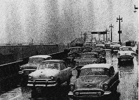
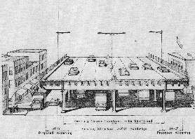
LEFT: In this 1957 photo, motorists slow down on a "reverse-S" curve at West 57th Street. RIGHT: This artist's rendition from 1965 shows the widened West Side Highway over West Street. (Photo and artist's rendition by Triborough Bridge and Tunnel Authority.)
|
|
|
|
|
|
|
|
|
|
|
|
|
|
|
|
|
|
|
|
DETERIORATING BEYOND REPAIR: In its 1966 report Transportation 1985: A Regional Plan, the Tri-State Transportation Commission made the following recommendation for the West Side Highway:
Throughout New York City, as well as in certain other portions of the region, there is an urgent need to replace and reconstruct outmoded and worn-out facilities. The city is unique in its need for highway renewal as well as urban renewal, for it has many early facilities that have undergone long and heavy usage. The prime candidate for replacement is the West Side Highway, whose tortuous curves and constricting width are far below modern design standards required for better speeds and higher volumes. The changed face of the City's waterfront also provides the opportunity to coordinate this highway reconstruction with potentially new and more appropriate uses of adjacent land. In such a case, highway renewal coupled with new land uses provides an unparalleled opportunity for civic improvements.
|
|
|
|
|
|
|
|
|
|
|
|
|
|
|
The inadequacies of the West Side Highway had become more acute by the early 1970s. The narrow ramps, left-hand entrance-exit ramps, sharp curves, and a crumbling structure posed serious hazards. Because of these hazards, cars could not travel at the speeds common on other area highways. Furthermore, trucks were prohibited from using the highway due to the inadequate size, shape and strength of the ramps and elevated structure. As New York City entered fiscally dire straits, it became more difficult for the City simply to maintain the existing highway in its deteriorated condition.
|
|
|
|
|
|
|
|
|
|
|
|
|
|
|
|
|
|
Ralph Herman, frequent contributor to NYCRoads.com and misc.transport.road, added the following on the original West Side Highway:
The roadway was cobblestone... It was originally designed as a four-lane highway, and in later years was marked as a six-lane road. I remember around 1970, the roadway was reduced back to four lanes in the area of the hairpin curves, where the speed was reduced from 40 MPH to 25 MPH.
It was a challenge to hold on to the steering wheel at 40 MPH with those cobblestones, and was extremely slick when wet. During heavy rainstorms, the tiny sewer gratings would clog up with road debris and silt, causing water to collect on the roadway at "low points" on the elevated structure. Because the curbing was so high, the water could get deep -- about a foot or so -- slowing traffic to a crawl. This was probably one of the few elevated roads that could be blocked due to flooding during a rainstorm!
|
|
|
|
|
|
|
|
|
|
|
|
|
|
 |
|
 |
|
|
|
|
|
|
|
|
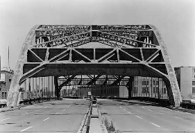
LEFT: The elevated West Side Highway at Gansevoort Street, not far from the collapsed section of highway. RIGHT: The West Side Highway crossed over Canal Street on a steel-arch span. (Photos by Library of Congress, Prints and Photographs Division, Historic American Buildings Survey / Historic American Engineering Collection, LC-HAER-NY31-NEYO-88-1 and LC-HAER-NY31-NEYO-88-15.)
|
|
|
|
|
|
|
|
|
|
|
|
|
|
 |
|
|
|
|
|
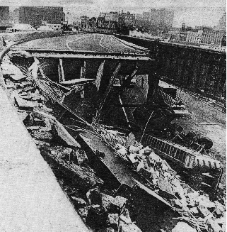
END OF THE HIGHWAY: On December 16, 1973, in the most ironic of circumstances, a cement truck that was traveling to make repairs on the West Side Highway caused a 60-foot section of the northbound roadway to collapse at Gansevoort Street. Immediately, the entire highway from the Battery north to West 46th Street was closed. Subsequent to the collapse and closure of this section, engineering inspections were made to determine if repairs could be made and this section could be reopened.
|
|
|
|
|
|
|
|
|
|
|
|
|
|
Analysis indicated that very extensive repairs would be required, which the New York City Department of Transportation (NYCDOT) declined to make because of its $88 million cost, and the fact that this repair would make no material improvements to the highway's capacity and safety characteristics. Not long thereafter, the NYCDOT closed the West Side Highway from West 46th Street north to West 57th Street.
Soon after the collapse of the elevated highway, a temporary roadway was hastily constructed along West Street and 12th Avenue. For a quarter-century after the collapse, this temporary highway served as the primary north-south highway on the West Side of Manhattan. Demolition of the elevated roadway, which began in 1977, would not be completed until 1989. In the intervening years, the abandoned roadway found multiple uses as a very popular running and bicycling path, as well as a staging area for concerts. From nycroads.com contributor Jeff Saltzman:
The rotting hulk of the old highway was eventually torn down in stages, but the section stretching from the 40s to 57th Street lingered on for years. My friends and I took in many a pier concert from that highway. It was a great place to hang out and gave great views of the concerts below.
|
|
|
|
|
|
|
|
|
|
|
|
|
|
 |
|
 |
|
|
|
|
|
|
|
|
LEFT: The aftermath of the December 16, 1973 collapse of the West Side Highway at Gansevoort Street. RIGHT: Shortly after the collapse, the entire length of the West Side Highway was closed to all traffic. The tight left-hand exits were among the characteristics that made the old highway functionally obsolete. (Photos by New York State Department of Transportation and Federal Highway Administration.)
|
|
|
|
|
|
|
|
|
|
|
|
|
|
|
|
|
|
|
|
|
|
|
|
 |
|
|
|
|
|
AFTER WESTWAY: In September 1986, the highway design firm Vollmer Associates was commissioned to develop alternatives for the West Side Highway Replacement Project. The four new proposals for NY 9A (now the working designation, as the I-478 designation was removed) were as follows:
|
|
|
|
|
|
|
|
|
|
|
|
|
|
Alternative 1 rebuilds the existing roadway (West Street-Twelfth Avenue) providing a 20-year life. New pavement, improved drainage, permanent median barriers, sidewalks and curbs are included. The alternative maintains the existing number of through lanes in each direction: three lanes south of Canal Street and two lanes north of that area. Pedestrian access is improved somewhat with several additional crossings and modest refuge areas in the center median between the north and south through roadways. Some landscaping is provided along the east sidewalk and in a planter strip adjacent to the southbound through roadway. The bicycle path is rebuilt along this planter strip. Because traffic conditions on Alternative 1 will be essentially that of the existing roadway without any improvement, Alternative 1 can be considered the "no-build" condition in the analysis of future impacts and benefits.
Alternative 2 provides longer turn lanes and slip ramps, wider medians between roadways and better alignment at the Gansevoort Street area than Alternative 1. A southbound frontage roadway is provided adjacent to Battery Park City, and access to the development is compatible with the internal roadway system. Wider medians provide ample pedestrian refuge areas and opportunities for landscaping. A bicycle path and walkway are provided along the western edge of the roadway.
Alternative 3 provides three through lanes in each direction throughout and incorporates the improvements in Alternative 2. Also provided are a southbound frontage road adjacent to the proposed Hudson River Center waterfront development (Chelsea Piers), and an improved alignment at West 23rd Street, requiring the taking of occupied private property in the block between West 23rd Street and West 24th Street, and Eleventh and Twelfth Avenues.
Alternative 4 introduces grade separations for through traffic. At the southern end of the corridor, two concepts are considered. One includes a depressed, reversible roadway providing access to Battery Park City and carrying traffic under the busy cross streets. The roadway would operate in the southbound direction, except during weekday morning rush hours when it would be reversed to handle the peak-direction traffic. The second concept provided a depressed section connecting with the Brooklyn-Battery Tunnel and the Battery Park underpass, thereby relieving the congestion at this location. The roadway is at-grade north of this area. At Canal Street, an overpass for northbound traffic reduces conflicts for southbound turning movements to and from the Holland Tunnel. Elevated through roadways are provided at the northern end, adjacent to the Convention Center, with one concept touching down at West 32nd Street and an alternative concept meeting grade at West 36th Street.
After seven additional years of delays, a coalition of local, city and state officials approved a variation of "Alternative 3" in May 1993. At a cost of $380 million, community board members called the urban boulevard "Lessway" because of its lower cost relative to earlier proposals for the West Side Highway.
The lane configurations for the new West Side Highway are as follows:
Brooklyn-Battery Tunnel (I-478) to Chambers Street: four lanes northbound, four lanes southbound
Chambers Street to West 14th Street: four lanes northbound, three lanes southbound
West 14th Street to West 24th Street: three lanes northbound, three lanes southbound
West 24th Street to West 42nd Street: four lanes northbound, three lanes southbound
West 42nd Street to West 57th Street: four lanes northbound, four lanes southbound
North of West 57th Street, the urban boulevard ties into the rebuilt "Miller Highway" viaduct. Originally constructed as an extension of the West Side Highway, this elevated highway opened in 1936 to serve as a connector to the Henry Hudson Parkway (which officially begins at West 72nd Street). Throughout the 1990's, the Federal and state governments spent $80 million to bring the viaduct up to current operational and seismic standards. (Preliminary studies are underway for the relocation of the elevated "Miller Highway" section from West 72nd Street south to West 59th Street.)
|
|
|
|
|
|
|
|
|
|
|
|
|
|
 |
|
 |
|
|
|
|
|
|
|
|
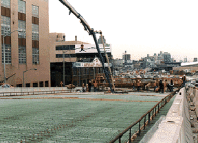
These photos taken during the spring of 1999 show the construction progress on the "new" West Side Highway. (Photos by New York State Department of Transportation.)
|
|
|
|
|
|
|
|
|
|
|
|
|
|
|
|
|
|
|
|
THE NEW WATERFRONT BOULEVARD: Working for the NYSDOT, project director John Ronayne said the following about the NY 9A proposal:
|
|
|
|
|
|
|
|
|
|
|
|
|
|
With its "context-sensitive" design, the West Side Highway is an integral part of the new Hudson River Park. Leslie Peoples elaborates in the following excerpt from Landscape Online:
The Route 9A urban boulevard reflects the development of new roadway construction features, and in some cases the creation of new design standards that allow for the design of an aesthetically pleasing roadway while meeting state and city safety criteria. Materials and details incorporated into the design of Route 9A not previously used by the state include low-profile barrier curbs, 19-foot wide medians, special lighting, granite block paving details and a stone wall to accommodate grade changes along a portion of the bikeway.
The raised medians, made possible by the low barrier curbs, were designed with safety and aesthetics in mind. While they discourage mid-block crossing by pedestrians and offer protection from traffic for those unable to cross the street in one-traffic cycle, the raised medians also enhance the boulevard concept by permitting planting of more and larger trees closer to the road. The height of the median protects the lush vegetation from vehicles and safeguards roadside plantings from salting, offering a suitable entrance to the waterfront park.
The corridor's overall feeling of continuity is conveyed not only by lush landscaping but also by urban design elements consistently used throughout the corridor. Decorative light poles, for example, convey the history of the area as well as the elegance of the urban boulevard. Their design is repeated in high and low street poles for uniformity. Similarly, paving material, chosen for its durability and aesthetic quality, is repeated in the bikeway, walkway and sidewalks along the corridor.
Construction of the new West Side Highway began in April 1996. The first section of the project, between Clarkson Street and Horatio Street, was finished in August 1998. The entire "NY 9A Reconstruction Project" was completed in August 2001.
According to the NYSDOT, the new West Side Highway handles approximately 75,000 vehicles per day (AADT). The I-478 designation remains today - albeit in truncated form - and applies only to the Brooklyn-Battery Tunnel and its approaches. There are no I-478 shields or NYSDOT reference markers along the West Side Highway itself.
|
|
|
|
|
|
|
|
|
|
|
|
RENAMING THE WEST SIDE HIGHWAY AFTER A BASEBALL GREAT: During ceremonies held at Yankee Stadium on April 25, 1999, the West Side Highway between Battery Park and West 72nd Street became the "Joe DiMaggio Highway." The highway was ceremonially renamed after the 13-year New York Yankee center fielder who is best remembered for his hitting streak that lasted 56 consecutive games during the 1941 season.
From the New York State Senate archives:
|
|
|
|
|
|
|
 |
|
|
|
|
|
|
|
|
|
|
Portion of the state highway system to be designated as the "Joe DiMaggio Highway:" Notwithstanding any other provision of law to the contrary, all that portion of the state highway system in the county of New York which is identified and known as the West Side Highway, the Miller Highway or Route 9A, running from Battery Place to West 72nd Street, shall be designated and known as the "Joe DiMaggio Highway."
|
|
|
|
|
|
|
|
|
|
|
|
|
|
|
 |
|
|
|
|
|
|
|
|
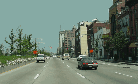
This 2000 photo shows the northbound West Side Highway (NY 9A) through the West Village. (Photo by Jim K. Georges.)
|
|
|
|
|
|
|
|
|
|
|
|
|
|
|
|
|
|
|
|
TOO LITTLE, TOO LATE? Despite its aesthetic benefits, the "Lessway" alternative has been criticized for inadequately dealing with present and future transportation demands along the West Side corridor. Douglas A. Willinger posted the following in misc.transport.road:
|
|
|
|
|
|
|
|
|
|
|
|
|
|
The wall of traffic along the west side on the surface, and the future expense of having to rip up the myopic West Side "Highway" - the boulevard now under construction - for the tunnel that should be a part of this existing construction project, is a legacy of letting those who oppose anything highway related be seen as necessarily synonymous with improving the environment. Indeed, a truly progressive solution would have been a Westway highway tunnel for I-478 express traffic, beneath a waterfront boulevard that would actually be able serve more as a low speed boulevard, with a waterfront trolley in the fashion of what was recently done along the Embarcadero in San Francisco.
Alexander Medwedew added the following post:
The striped bass argument against Westway really was bogus. Rather, the real threat to the stripped bass is over-fishing. The fact that the bass were able to spawn before the piers were built and will probably do very well when the piers are removed is something that no one seems to understand. If the environmentalists were true to their cause to help the stripped bass, these piers and other man-made obstructions would have to be removed. Indeed, many of these piers have ceased to exist due to decay. Returning the Hudson River to its original state is something that would make more sense.
The resulting loss of Westway has caused many problems for New York, one of which is massive traffic congestion due to mixture of through and local traffic on city streets. The air pollution created by trucks traveling on local streets could have been reduced if moved underground.
New York City has been developed heavily above ground. Real estate developers and community groups are constantly battling about air rights over a limited amount of land. The last resource for expansion is underground. As I see it, tunnels are the only way to route certain kinds of traffic though New York City. If it had been approved, Westway would have been a start in the right direction.
|
|
|
|
|
|
|
|
|
|
|
|
|
|
|
 |
|
|
|
|
|
|
|
|
This 2000 photo shows the northbound West Side Highway (NY 9A) approaching the World Trade Center and World Financial Center. Reconstruction of the landscaped arterial was still underway. (Photo by Jim K. Georges.)
|
|
|
|
|
|
|
|
|
|
|
|
|
|
|
|
|
|
|
|
THE IMPACT OF SEPTEMBER 11, AND TALK OF A NEW TUNNEL: The destruction caused by the September 11, 2001 terrorist attack on the World Trade Center will necessitate reconstruction of the recently completed section from the Brooklyn-Battery Tunnel north to Chambers Street. For more than six months, the boulevard was closed in this area to all traffic except official and construction vehicles.
|
|
|
|
|
|
|
|
|
|
|
|
|
|
As an interim measure, the NYSDOT constructed a six-lane temporary roadway between Vesey Street and Liberty Street, in the area between the World Trade Center site and the World Financial Center. The temporary roadway, which provides access to the Brooklyn-Battery Tunnel, opened on March 29, 2002.
Since the temporary roadway opened to traffic, the NYSDOT presented three alternatives to restore capacity through the area of the World Trade Center site. These alternatives were as follows:
NO-BUILD: The at-grade alternative would restore the West Side Highway to its pre-9/11/2001 capacity of eight lanes (four in each direction). The restoration of the boulevard alternative would require a slight alignment shift to the west in order to avoid the now-exposed slurry wall at the World Trade Center site. The alternative would have left-turn lanes at Liberty and Vesey streets, a wide planted median, and accommodation for a tunneled pedestrian concourse between the World Financial Center and the World Trade Center (PATH-MTA) underground transit facilities. The $175 million plan would take two and one-half years to plan and construct.
SHORT TUNNEL: This alternative also would restore eight lanes through the area of the World Trade Center site by depressing four through-traffic lanes and providing four local lanes at-grade. The bypass would drop below existing street grade north of Albany Street and rise to street level just south of Murray Street. Approximately 75 percent of the traffic on NY 9A would utilize the tunnel. The 30-foot-wide landscaped median atop the tunnel would create a pedestrian-friendly environment, and help reconnect Battery Park City to the rest of lower Manhattan. (However, some contend that air pollution would increase near tunnel portals.) This alternative also would accommodate an underground walkway between the World Financial Center and the World Trade Center (PATH-MTA) underground transit facilities. The $860 million plan would take two and one-half years to plan and construct, though this schedule could be compressed through a design-build process.
LONG TUNNEL: This alternative would have called for the construction of a four-lane tunnel stretching three-quarters of a mile from the Brooklyn-Battery Tunnel north to Murray Street. Above ground, the alternative would have accommodated six lanes for local traffic. The $2.3 billion plan would have taken up to nine years to design and build, and required a new environmental impact statement to be drafted. Because of the efforts of groups such as "Save West Street," which opposed a new tunnel due to cost and community disruption concerns, the NYSDOT dropped this alternative.
On April 13, 2005, Governor George Pataki, who had been a proponent of a tunnel, reversed his position after Goldman Sachs abandoned plans to build a new 40-story headquarters tower on West Street at the northern portal of the proposed tunnel.
TRUMP GETS HIS WISH, WITH HELP FROM THE CITY: In July 2005, a state appeals court upheld a decision by city officials to close the northbound ramp at EXIT 9 (West 72nd Street) to accommodate the $3 billion Trump Place (now Riverside South) project that at the time was being developed by future President Donald Trump. The decision, which reversed a lower court ruling blocking the closure, allows the NYCDOT to begin closing the northbound exit. The NYCDOT based its decision to close the exit on a 1992 environmental impact statement and a 2003 follow-up study, which stated the closure would not have a detrimental effect on traffic or air quality.
|
|
|
|
|
|
|
|
|
|
|
|
CONNECTING TO OTHER GREENWAYS: The Route 9A pedestrian and bike paths ultimately will connect with waterside paths through the Riverside South development and the parks extending to the northern tip of Manhattan. With connections to the Bronx and Staten Island, the route will link with the planned Hudson River Valley Greenway from Westchester to Albany. The Route 9A Greenway would form the western leg of the East Coast Greenway through Manhattan. The eastern leg of the East Coast Greenway is currently being built along the FDR Drive and the East River.
|
|
|
|
|
|
|
 |
|
|
|
|
|
|
|
|
 |
|
|
|
|
|
 |
|
|
|
|
|
|
|
|
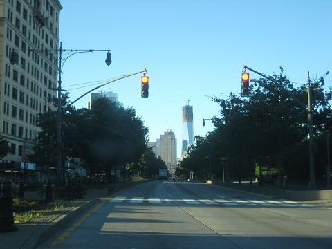
This 2012 photo shows the West Side Highway (NY 9A) looking south towards Lower Manhattan. The roadway was rebuilt as a landscaped boulevard from 1995 to 2001. The new One World Trade Center is shown nearing completion; the skyscraper was finished the following year. (Photo by Steve Anderson.)
|
|
|
|
|
|
|
|
|
|
|
|
|
|
|
|
|
|
|
 |
|
|
|
 |
|
|
|
 |
|
|
|
|
|
PLANNING A NEW WATERFRONT INTERSTATE: Before the demise of the original West Side Highway in 1973, plans were already being drawn up for its replacement. In 1971, the "Wateredge" project was announced. Unlike its progeny, the "Wateredge" highway was to have been built on piles, not on landfill. Above the highway and an adjacent "transitway" (designed for either a new subway line or dedicated bus lanes, or both), 700 acres were to have been created between the Battery and West 72nd Street. This would have provided enough room for 85,000 new apartments, as well as a new 150-acre park.
|
|
|
|
|
|
|
|
|
|
|
|
|
|
The new expressway proposal captured the attention of Governor Nelson Rockefeller and Mayor John Lindsay, both of whom proposed using Interstate funds for construction of "Wateredge." In exchange for cancellation of other Interstate projects through New York City (most notably the "I-78 through NYC" plan), the new highway was to get the I-478 designation.
By 1974, John Zuccotti, chairman of the New York City Planning Commission, dubbed a new name for the project: Westway. By then, opposition to the proposed highway was starting to grow. Hugh Carey, a Brooklyn Congressman running for governor, and Edward Koch, the Manhattan Congressman who would later become mayor, led groups contending that the I-478 Westway would generate more traffic, drain city resources, and cause environmental damage in the city and beyond. In response to comments that the proposed highway was "a waste of government funds" and "a giveaway to developers," proponents of Westway defended its environmental and economic on lower Manhattan and the West Side. By the mid-1970's, both areas had been particularly hard-hit by the loss of manufacturing and shipping jobs.
WESTWAY ALTERNATIVES: The six alternative proposals for Westway were described in the Final Environmental Impact Statement as follows:
OUTBOARD: The original outboard alternative consisted of three major transportation facilities - a six-lane Interstate highway, a new transitway, and a reconstructed West Street and Twelfth Avenue. This alternative would provide a significant transformation of the Hudson River waterfront. Likewise, all of the existing waterfront facilities south of 37th Street would be demolished and replaced by 243 acres of new landfill from Battery Park City to West 34th Street. The Interstate highway would be a six-lane, limited-access facility, and would be depressed, covered and ventilated in newly created land near the pierhead line for most of its length. In lower Manhattan, however, the facility would be depressed and partially covered in the existing West Street right-of-way. Full directional interchanges were proposed at the Brooklyn-Battery, Holland and Lincoln Tunnels, and connections would also be provided with the Battery Park Underpass, West 14th Street, and connecting with the existing West Side Highway at West 43rd Street. The transitway would be a depressed and covered facility throughout the length o the corridor, located adjacent to the new highway. The transitway could accommodate either bus or rail systems, and could be converted from an express bus system to rail. West Street and Twelfth Avenue would be reconstructed in its present right-of-way as a service road, providing three lanes of traffic in each direction.
MODIFIED OUTBOARD: The "modified outboard" alternative was similar in many ways to the original "outboard" proposal. The new 4.2-mile highway was to have been located on a new alignment in waterfront landfill for much of its length between the Brooklyn-Battery Tunnel and West 42nd Street, except in Lower Manhattan where it was have utilized the existing West Street-West Side Highway right-of-way. Access points were to have been provided at the Battery Park Underpass, Greenwich Street, Canal Street-Holland Tunnel (Interstate 78), West 14th Street, West 30th Street-Lincoln Tunnel (Interstate 495) and West 42nd Street. During the morning and evening rush hours, the inner lane of the highway in each direction was to be designed to accommodate an HOV lane for express buses and other high-occupancy vehicles. This alternative would have required the creation of fewer acres of landfill - 93 acres versus 243 acres - than the original "outboard" proposal. Furthermore, because of its lower capacity - this alternative featured a four-lane West Street replacement and no separate transitway - the "modified outboard" alternative was seen as less disruptive and less costly than the original proposal.
ARTERIAL: The "arterial" alternative proposed the replacement of the existing West Side Highway with two new transportation facilities: an at-grade arterial from Battery Place to West 59th Street, and a depressed and covered transitway. Both facilities were to have utilized the existing West Street right-of-way. No new land for redevelopment would have been created. This facility would have provided lower traffic capacity than the pre-existing West Side Highway and West Street combination.
MAINTENANCE: The "maintenance" proposal for the West Side Highway was the closest to the "no-build" alternative. Such a proposal would have consisted of repairs to the deck and supporting structure of the roadway between the Battery and West 72nd Street. (A provision would have been made for a replacement of the elevated roadway between Jane Street and West 26th Street - the section affected by the December 1973 collapse.) Like the pre-existing highway, this proposal contemplated that trucks would not be able to use the alternative, shifting them to local streets. Studies on this alternative found that repairing and maintaining the existing highway would have resulted in increased congestion, higher accident rates (due to the fact that none of the sharp curves and narrow ramps would have been rectified) and worsened air quality.
RECONSTRUCTION: The "reconstruction" proposal would have provided for the rehabilitation and partial reconstruction of the existing West Side Highway between the Battery and West 72nd Street. Specific modifications included new access ramps, the elimination of sharp curves, and the provision of safety shoulders that would have removed some of the most dangerous features of the existing highway. Unlike the "maintenance" proposal, trucks would have been permitted to use the rehabilitated highway. While providing improved safety and operational benefits, however, the capacity of the highway would have been reduced from six to four lanes. According to the EIS Statement, "its marginal operational and safety improvements would not balance negative environmental impacts and high construction costs."
INBOARD: The "inboard" alternative would have created three new transportation facilities: a six-lane Interstate highway, a new transitway, and a reconstructed West Street-Twelfth Avenue. Unlike the two "outboard" alternatives described earlier, no new land or land uses were to have been created. Indeed, the alternative was designed to preserve the existing character and facilities of the existing Hudson River waterfront. Although it provided as much traffic service as the "outboard" alternatives, the "inboard" proposal "failed to produce significant additional benefits to offset its high costs." According to the EIS Statement, "the alternative failed to overcome some of the most prominent objections to highway construction in urban areas."
On March 7, 1975, Governor Hugh Carey (who previously opposed Westway) and Mayor Abraham Beame approved the "modified outboard" alternative. An extension of the I-478 designation along the Henry Hudson Parkway (NY 9A) north of West 59th Street, which would have necessitated further reconstruction to accommodate commercial traffic, was rejected as part of the Westway proposal.
MORE INFORMATION ON HIGHWAY TUNNELS: The "modified alternative" would have involved the construction of highway tunnels throughout a significant portion of its length. Douglas A. Willinger of the Takoma Park Highway Design Studio, frequent contributor to NYCRoads.com and misc.transport.road, provides the following information on highway tunnels:
Roadway tunnels are a logical means of constructing a limited-access roadway, where an exposed surface roadway may be locally undesirable for environmental and aesthetic reasons, where such a project would be impossible politically, and where there is a significant degree of traffic demand (given the undeniable extra costs). These highway tunnel segments can be constructed along waterfronts, through or adjacent to some central business districts, and through or adjacent to neighborhoods. In all three cases, the need for encasing the highway is directly related to its proximity to built-up areas.
Roadway tunnels, which can be seen as roadway encasing with the necessary structure, provide the opportunity to reconcile the conflicting needs. For example, such tunnels can bring traffic through areas that would have the greatest need for expressways, yet are unwilling to accept a conventional surface highway as a neighbor because of its concomitant noise and air pollution.
Cut-and-cover (or trench-and-bury) tunnels are generally appropriate in areas with significant existing rights-of-way, including existing surface streets, existing limited-access divided highways, railroads and utility rights-of-way. Cut-and-cover tunnel construction, though requiring surface disruption, allows the possibility for creative redevelopment of such existing corridors, including more attractive surface boulevards atop the cut and cover tunnel, as well as the creation of linear greenways as being done with the current Central Artery / Tunnel project (I-93) in Boston. The nearby buried segment of US 1 to the immediate northeast of Boston's CBD with its Charlestown Town Square (constructed during the late 1980's and early 1990's) provides a splendid example of this potential on a smaller scale.
Bored tunnels are especially appropriate for constructing a limited-access roadway where no such acceptable surface right of way exists for constructing a sufficiently wide highway when surface options are clearly not politically feasible. Logical candidates for such projects would be those where the area is too built up, especially if there are historic buildings that lack acceptable existing surface corridors to recycle, such as can be accomplished through a cut-and-cover project. While cut-and-cover can be quite feasible with slurry wall construction, areas lacking such potential rights-of-way would require surface demolition, whereas tunnel boring offers the potential to avoid undesirable demolitions. An older city with narrow or twisted street grids need not be ripped into two, not have its historic districts partially demolished for bringing its road network into the twenty-first century.
MOSES WEIGHES IN ON WESTWAY: In November 1975, Robert Moses, by then an 87-year-old "consultant" for the TBTA, made his opinion known on Westway in the Civil Engineering-ASCE Magazine piece "A Practical Proposal for Restoring Manhattan's West Side Highway." Moses analyzed the proposals as follows:
"OUTBOARD" (ALTERNATIVES 1 AND 2): (remove existing structure and construct new Interstate highway similar to Inboard Alternative, except that the northerly half is in a tunnel built in fill deposited out in the Hudson River): cost $1.2 billion
"ARTERIAL" (ALTERNATIVE 3): cost $76 million
"MAINTENANCE" (ALTERNATIVE 4): cost $86 million
"RECONSTRUCTION" (ALTERNATIVE 5): cost $239 million
"INBOARD" (ALTERNATIVE 6): cost $950 million
Upon analyzing these alternatives, Moses rejected the "maintenance" and "arterial" alternatives because they would provide no traffic solution, and rejected the "inboard" and "outboard" alternatives because of their cost. He added, "New York State's entire Interstate share for 10 years would not pay this West Side Manhattan bill. And construction of either of these two alternatives would take 12 years."
Moses' proposal was a compromise. He proposed salvaging the parts of the highway that were salvageable. From the Battery north to Canal Street, he recommended replacing the elevated structure with a highway at grade with separated crossings where required. From Canal Street north to West 59th Street, he recommended repairing, strengthening, and refurbishing the existing structure, taking out abrupt curves and providing improved ramp arrangements. From West 59th Street to West 72nd Street, he recommended relocating the highway to the easterly portion of a scheduled-to-be-abandoned railroad freight yard. North of West 72nd Street, along the Henry Hudson Parkway, he said that structures needed repair only.
According to Moses, this proposal would be completed in three to four years "at a reasonable cost." (He did not provide a cost estimate in the article.)
|
|
|
|
|
|
|
|
|
|
|
|
|
|
|
 |
|
|
|
|
|
|
|
|
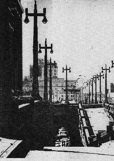
The existing West Side Highway, facing north along the Upper West Side. This section of NY 9A (from West 59th Street north to West 72nd Street) leading into the Henry Hudson Parkway is the only existing limited-access portion remaining. (Photo by Parsons-Brinckerhoff.)
|
|
|
|
|
|
|
|
|
|
|
|
|
|
|
|
|
|
|
|
|
|
|
|
|
|
|
|
|
|
THE BATTLE OVER WESTWAY: In 1978, newly elected Mayor Ed Koch also changed his mind, joining Governor Carey in his support of the Westway superhighway and Westway State Park. In August 1981, just as the Army Corps of Engineers were granted a dredging and landfill permit, President Ronald Reagan joined in his support of Westway, ceremonially cutting an $85 million check to state and city officials. However, transportation officials and fiscal conservatives at the Federal level joined in a loose alliance with bureaucrats and environmentalists to undermine Westway.
|
|
|
|
|
|
|
|
|
|
|
|
|
|
The bipartisan agreement was reported in The New York Times as follows:
The agreement by the two Democratic leaders after ten years of wrangling between the city and state established the highway project as "the official policy" for the replacement of the West Side Highway between the Battery and West 42nd Street in Manhattan. The Westway is planned as a 4.2-mile roadway, sunken in some places and elevated in others, running along the Hudson River. It would be surrounded by 93 acres of parkland and 110 acres of landfill for future residential and commercial development. The cost would be more than $2.3 billion (in 1981 dollars).
In 1982, Judge Thomas Griesa of U.S. District Court blocked the 1981 landfill permit, citing that the Corps of Engineers failed to assess the impact of the landfill on striped bass in the Hudson River. After three more years of delays and additional study, the Corps determined that at most, one-third of the striped bass in the Hudson would not survive the dredging and construction process. Still, Judge Griesa would not issue construction permits, citing that the evaluation procedures were inadequate. Governor Mario Cuomo, the third Governor to support Westway, vowed a swift repeal of the decision.
However, after a 14-year battle, opposition forces finally gained victory. On September 30, 1985, New York City leaders decided to abandon Westway, allocating 60 percent of the approximately $1.7 billion in Federal Interstate funds to mass transit. The other 40 percent (about $690 million) of Federal funds, plus an additional state and city share of $121 million, was to be allocated to the "West Side Highway Replacement Project." This $811 million cap was to include the entire replacement facility from Battery Place north to West 59th Street.
When the project was killed, The New York Times, historically a pro-highway voice during the Robert Moses era, had this to say about the demise of Westway:
Why did a project offering so much to so many finally fall as flat as the old elevated West Side Highway it was to replace? The answer is horror of the automobile.
|
|
|
|
|
|
|
|
|
|
|
|
|
|
|
 |
|
|
|
|
|
|
|
|
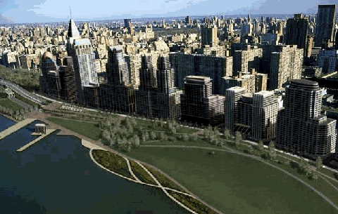
Simulation of plan to create underground West Side Highway, along with riverfront park along the Hudson River, near the same location as the photo above. (Photo composite by Parsons-Brinckerhoff.)
|
|
|
|
|
|
|
|
|
|
|
|
|
|
 |
|
|
|
|
|
WESTWAY REVISITED? Douglas A. Willinger submitted the following proposal for placing the West Side Highway underground in lower Manhattan:
A tunneled roadway that transitions to a surface roadway (on an essentially flat grade) would require an uncovered depressed roadway transition, and any interstate highway design (this being connected to the Brooklyn-Battery Tunnel / I-478) would have grading requirements for mixed traffic.
|
|
|
|
|
|
|
|
|
|
|
|
|
|
Placing the West Side Highway underground would go far to improve the environment for the people who live and work in the area, not only by improving waterfront access and pedestrian activity, but also by reducing ambient noise pin noise abatement. Furthermore, since this would be an encased roadway in a built up area, its ventilation would be equipped with a filtration (rather than mere dilution) system. The more traffic that it can handle, the more traffic emissions it may capture, rather than simply be released into the general atmosphere.
|
|
|
|
|
|
|
|
|
 |
|
|
|
|
|
|
|
|
|
|
|
|
|
 |
|
|
|
|
|
SOURCES: "New York Rebuilds Itself on a Huge Scale" by James C. Young, The New York Times (7/27/1926); "Miller Highway-West Side Elevated Improvement," Triborough Bridge and Tunnel Authority (1957); "Plan To Increase the Capacity of the Miller Highway and Henry Hudson Parkway," Triborough Bridge and Tunnel Authority (1965); Transportation 1985: A Regional Plan, Tri-State Transportation Commission (1966); "Estimate of the Cost of Completing the National System of Defense Highways in New York," Federal Highway Administration and New York State Department of Transportation (1971); "West Side Highway-Interstate Route 478, Summary of Alternatives," Federal Highway Administration and New York State Department of Transportation (1974); The Power Broker by Robert A. Caro, Vintage Books-Random House (1974); "A Practical Proposal for Restoring Manhattan's West Side Highway" by Robert Moses, Civil Engineering-ASCE Magazine (November 1975); "West Side Highway-Interstate Route 478, Administrative Action Final Environmental Impact Statement and Section 4(f) Statement," Federal Highway Administration and New York State Department of Transportation (1977); "Battle of the Westway: Bitter 10-Year Saga of a Vision on Hold" by Sam Roberts, The New York Times (6/04/1984); "US Judge Blocks New York Highway Project" by Ellan Cates, The National Law Journal (8/26/1985); "West Side Highway Replacement Study: Final Report," Vollmer Associates (September 1986); "Westway Task Force to Release Final Highway Recommendations" by Carol Polsky, Newsday (1/08/1987); "City-State Pact Paves Way for New Road on West Side" by Rex Smith and Marianne Arneberg, Newsday (8/22/1987); "West Side Highway Proposal" by Jose Gomez-Ibanez and Marc Roberts, Harvard University-Kennedy School of Government (1989); "The Miller Highway: Razed or Rebuilt, It's a Lost Cause" by Christopher Gray, The New York Times (2/17/1991); "End of Road for Westway is 'Lessway'" by Molly Gordy, Newsday (5/13/1993); "Final Environmental Impact Statement, Design Report and Section 4(f) Statement for Route 9A Reconstruction Project," U.S. Department of Transportation (1994); Toll Facilities in the United States, Federal Highway Administration (February 1997); "A Green Boulevard for Manhattan's West Side" by Leslie Peoples, Landscape Online (1997); "Highway Hopes That Faded" by Sidney C. Schaer, Newsday (11/05/1999); "A Ghost of Westway Rises Along the Hudson" by Adam Nagourney, The New York Times (3/03/2002); "Crews Are Rushing To Restore WTC's Hard-Hit Infrastructure" by Debra K. Rubin, Engineering News-Record (3/11/2002); "Downtown, A Debate Over Burying West Street" by Edward Wyatt, The New York Times (10/01/2002); "Tunnel Vision on West Street" by Steve Cuozzo, New York Post (12/30/2004); "Heeding Outcry, State Drops Plans for Tunnel at Ground Zero" by David W. Dunlap, The New York Times (4/14/2005); "New York Is Supported in Ruling on Exit Ramp" by Robert F. Worth, The New York Times (7/16/2005); American Society of Civil Engineers; New York City Planning Department; New York Metropolitan Transportation Council; New York State Department of Transportation; Ralph Herman; Hilary Kitasei; Scott Kozel; Alexander Medwedew; Jeff Saltzman; Steve Summers; Kevin Walsh; Douglas A. Willinger; William F. Yurasko.
NY 9A, NY 27A, and I-478 shields by Ralph Herman.
Lightposts by Jeff Saltzman.
Bike route sign by Richard C. Moeur.
Bridge abutment "wheel" detail photo by Kurt Kaufman.
Joe DiMaggio plaque photo by William F. Yurasko.
|
|
|
|
|
|
|
|
|
|
|
|
|
|
|
|
|
|
 |
|
|
|
|
|
|
|
|
|
|
|
|
|
|
|
|
|
|
|
|
|
 |
|
|
|
|
|
|
|
|
|
 |
|
|
|
|
|
|
|
|
 |
|
|
|
|
|
|
|
|
 |
|
|
|
|
|
|
|
|
|
|
|
|
Site contents © by Eastern Roads. This is not an official site run by a government agency. Recommendations provided on this site are strictly those of the author and contributors, not of any government or corporate entity.
|
|
|
|
|
|
|
|
|
|