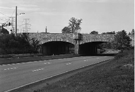
This 2000 photo shows the northbound Taconic State Parkway at US 6 in Yorktown, Westchester County. Note the original stone-arch overpass and single-carriageway construction. A "box-rail" barrier was added later. (Photo by Steve Anderson.)
THE TACONIC PARKWAY IN WESTCHESTER COUNTY: Originally designated as the "Bronx Parkway Extension," the route of the Taconic State Parkway was approved by the New York State Legislature in 1923. Combined with the already completed section of the Bronx River Parkway, this section of the Taconic was to provide a scenic, rapid route from New York City to the Bear Mountain Bridge and points north.
In Yorktown, near the Westchester-Putnam county border, the Bronx Parkway extension was to diverge. The left fork was to make a 90-degree turn from north to west. This section, which later became known as the Bear Mountain State Parkway, was originally part of the "Bronx Parkway Extension." The right fork was to continue north to the "Eastern State Parkway," which later became the Taconic State Parkway.
Work began on the 20.7 miles of the Taconic State Parkway through Westchester County in 1927. Four years later, the Westchester County Park Commission Report described the natural attractions of the region through which the parkway passed as follows:
From Briarcliff Manor northward through Mohansic Park and leading up to the gateway of the Hudson River Highlands at Peekskill, the parkway threads a region of wild, picturesque scenery. The parkway will disclose the scenic charm of a region of Westchester now unknown to the motoring public.
The new Taconic State Parkway, which included one major park and three small picnic areas, was completed in 1932 in two parts: the "Bronx Parkway Extension" from the Kensico Dam Plaza to the Bear Mountain Parkway, and the four-mile-long spur north to the Westchester-Putnam border, known as the "state parkway," which linked the Westchester parkway system to the parkway being planned by the new Taconic State Park Commission.
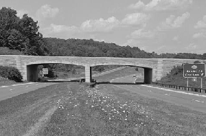
When the Taconic State Parkway was completed through Westchester County, it consisted of a 42-foot-wide undivided roadway, 12 highway bridges, two railroad bridges, and a 750-foot steel arch bridge spanning Croton Lake. With the exception of the Croton Lake Bridge, the grade separations followed the stone-arch design convention established earlier on the Long Island and Westchester parkways. Service stations and restaurants built along the route were designed to blend in with the rustic surroundings of the areas through which the parkway passed.
The Taconic State Parkway continued the design precepts of the original Bronx River Parkway north through Westchester County. Like its predecessor, the Taconic State Parkway took a valley route, and was designed with narrow, unseparated lanes, a relatively narrow right-of-way, and a tightly framed landscape (consisting of local vegetation and earthen berms) that screened out the dense development of the county. The Taconic State Parkway played an important role not only establishing standards in transportation planning, but also in preserving open space amid rapid suburbanization.
This parkway section was maintained by Westchester County until 1961, when it was transferred to the East Hudson Parkway Authority, a New York State agency. When the last of the agency's bonds were paid off in 1980, jurisdiction over the parkway was transferred to the New York State Department of Transportation (NYSDOT).
LEFT: This 1940 photo shows the Taconic State Parkway looking north through Hudson Highlands. The original "Eastern State Parkway" was built as a four-lane undivided roadway through the area. (Photo from Historic American Buildings Survey/Historic American Engineering Record, #HAER, NY, 014-POKEP.V, 1-101.) RIGHT: This more recent photo shows the Taconic State Parkway looking north at the NY 203 interchange in Chatham. The "standardized" stone-arch design overpass was erected in 1960. Later sections of the parkway benefited from safety advances such as wide grade medians and higher design speeds. (Photo from Historic American Buildings Survey/Historic American Engineering Record, #HAER, NY, 014-POKEP.V, 1-96.)
THE TACONIC PARKWAY UPSTATE: In 1924, one year after it approved the route of the "Bronx Parkway Extension," the New York State Legislature created the Taconic State Park Commission (TSPC). The parkway and four proposed state parks tied to the parkway were to provide the backbone for the state park system in the eastern Hudson Valley.
However, the northward progress of the Taconic State Parkway ran into roadblocks. Desiring to make the Catskill and Adirondack regions more accessible to New Yorkers, Franklin D. Roosevelt, the new chairman of the Taconic State Park Commission under Governor Al Smith, sought to extend the Bronx River Parkway through the Hudson Valley all the way north to Albany.
At the same time, Robert Moses was seeking to procure funds for his Long Island park and arterial system. Moses had a distinct advantage: he chaired the State Parks Council, which allocated funds to parks and parkway projects throughout the state. Moses slashed Roosevelt's budget requests, and even said that the Taconic Parkway should not extend north to Albany, but end in Westchester County.
More on the Moses-FDR feud from Robert A. Caro's The Power Broker:
Roosevelt had at least one bitter face-to-face confrontation with Moses, the details of which can only be imagined. Then Roosevelt tried to go over Moses' head. In December 1926, he wrote Smith asking the Governor to restore the funds he had requested. "It is an absurd and humiliating position to be put in, to be informed that we could have no money because through lack of an Executive we have not been able to properly expend the money we had and then to be informed that we cannot have an Executive because we have not been given more money," he wrote.
But Smith was taking Moses' word as to what was happening in park matters. He asked Moses about the Taconic situation and Moses wrote Smith: "I suggest you write him (Roosevelt) a letter along the line attached." The "attached said that of course the parkway would go through - it did not say through to where - but that there was so much competition for the limited money available that it must be concentrated on those projects which were moving ahead fastest, and the Taconic Parkway was not one of those
A year later, the State Parks Council eliminated from the Taconic Commission's request all funds except those needed for bare maintenance of existing parks. "Moses simply used us," Roosevelt said. "The enormous appropriations for Long Island, while perhaps necessary, prove merely that we have been completely useful to other people."
With no pressing transportation or development problems, the focus of the parkway was to be strictly recreational in nature. The route of the parkway avoided towns and villages, and like the earlier section, incorporated parks in its design.
Roosevelt selected a route that would take motorists through a high, narrow ridge bounded by the Hudson River and the Catskills Mountains to the west, and by the Berkshire Mountains to the east. Unlike Moses, whose parkways encouraged the motorist to remain focused on the right-of-way, Roosevelt incorporated the sweeping landscape of rugged mountains and family farms into the design of the northern Taconic. This pastoral landscape supported his view of the history of the Hudson Valley.
Kathleen LaFrank, historic preservation program analyst for the New York State Historic Preservation Office, breaks down the three sections constructed by the TSPC as follows:
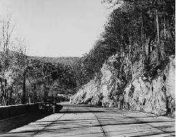
PUTNAM COUNTY-DUTCHESS COUNTY (1932-1938): Like the Westchester section, the first section completed by the TSPC follows earlier models. Built in two parts, this took the Taconic through Putnam County and into southern Dutchess County. This section also featured narrow, undivided lanes; however, taking the parkway through rugged mountainous terrain was a new challenge. Deep cuts were necessary, and the steep terrain dictated extensive use of stone retaining walls and rustic wooden guardrails. The road followed a tightly curving alignment, and although the effect of driving through a narrow corridor was repeated here, it was created using the natural environment. Features included large rock outcroppings and formal paintings closely integrated with native ones. Concrete curbs were square, integral and cast in place. This section also combined recreational uses by pairing the parkway with an extensive network of bridle paths. Bridges were narrow and rustic in nature, with large uncut stones laid with thick mortar (at FDR's insistence); interchanges were small and tightly configured.
DUTCHESS COUNTY-COLUMBIA COUNTY (1938-1955): The next portion of parkway, which covers the rest of Dutchess County and the southern end of Columbia County, was constructed in four parts. In southern Dutchess County, the landscape begins to open up into rolling farmland. The parkway landscape seems enormous because views begin to expand to the Catskills. Curbs are still square; lanes are consistently separated. Curves become longer, the grade gentler and the median wider. Lanes are often at different elevations. Landscaping with native plants continues, more formal in the median and naturalistic in the right-of-way. Reforestation is used to enhance the native landscape rather than exclude it. As the parkway moves north, a new concrete curb type, mountable, hand-fluted and painted with white metallic paint, is introduced. Bridges retain stone facing, but become more regular and less rustic (as do guardrails), and interchanges are significantly larger and more fully developed.
COLUMBIA COUNTY (1955-1963): The rest of the parkway, through the remainder of Columbia County, was constructed in three sections. The route is slightly more elevated, and long views become more predominant. Two overlooks here provide views that are among the most dramatic on the parkway. This section is very much like the previous one; however, bridges are more contemporary and streamlined; in some cases, designs combine steel structures with smaller amounts of regular stone facing (such as on the abutments only). While the road up to this point was uniformly concrete, the very last section to be completed was paved with asphalt.
After four decades of planning and construction, the 105.3-mile-long Taconic State Parkway was completed in November 1963. At the completion of one of the sections, Moses - who earlier locked horns with FDR on this issue - spoke favorably of the parkway as follows:
Rolling through the natural scenic charm of one of New York State's most beautiful country regions, the (Taconic State) Parkway is a composite of safety, beauty and utility, representing every known facility for safe and modern parkway construction yet devised While safety engineering has been the starting point for designing and constructing the parkway, at the same time the Taconic State Park Commission has sought to provide a parkway that takes advantage of all the natural beauty New York's country area provides.
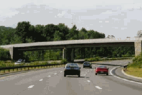
LEFT: This photo from the 1990's shows the northbound Taconic State Parkway at NY 117 in Pleasantville. (Photo from Historic American Buildings Survey/Historic American Engineering Record, #HAER, NY, 014-POKEP.V, 1-4.) RIGHT: This 1998 photo shows the northbound Taconic State Parkway at the northbound connector to NY 9A-NY 100 in Pleasantville. During the 1970's and 1980's, the parkway was reconstructed through much of Westchester County. The project saw the construction of a new carriageway (bringing capacity from four to six lanes) and the removal of at-grade intersections. (Photo by Steve Anderson.)
DESIGN CHANGES: With the northern extension of the Taconic State Parkway shelved, officials at the East Hudson Parkway Authority focused on reconstruction efforts, particularly in Westchester County. In 1965, the NYSPDW purchased 22 miles of the New York Central Railroad's old Putnam Division, which had been abandoned seven years earlier. Most of this land lay adjacent to the Taconic State and Saw Mill River parkways in Westchester County.
In 1969, the NYSDOT released a master plan for the Taconic State Parkway that recommended eliminating the 22 remaining grade crossings north of Westchester County. According to Robert Dennison, regional director at the NYSDOT, the plan was developed before community, environmental and historic preservation concerns had to be taken into account.
In the ensuing years, the NYSDOT implemented the following changes along the parkway through Westchester County:
Between 1969 and 1972, the section from NY 100-NY 133 in Millwood to US 202-NY 35 in Yorktown was widened to six lanes. Included in this widening was a parallel steel-girder span over the Croton Reservoir.
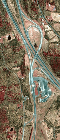
In 1972, the dangerous "Hawthorne Circle" with the Saw Mill River Parkway was replaced with a three-level interchange. The interchange, which has crossover ramps on the center level, provides only parallel connections (i.e., north-to-north, south-to-south); reverse connections are not provided. The $25 million interchange project took three years to complete.
In 1980, the NYSDOT completed a new interchange to connect the Taconic State Parkway with the newly completed Sprain Brook Parkway in Hawthorne. The bridges at this interchange were actually built in the early 1970's, in anticipation of the Sprain Brook Parkway completion. (A traffic turnabout at this location is no longer used.)
In the late 1980s and early 1990s, the section from NY 100-NY 133 in Yorktown south to the Saw Mill River Parkway was finally widened to six lanes, and the dangerous at-grade intersections along this section were finally removed.
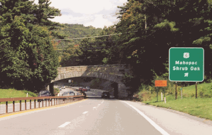
In the early 1990s, a parallel bridge was built over US 6 in Yorktown for southbound traffic. Northbound traffic continues to use the original bridge.
Several at-grade intersections remain along the parkway from the Kensico Dam Plaza circle (at the intersection of the Bronx River Parkway and NY 22) in Valhalla north to Stevens Avenue in Mount Pleasant.
Further north in Putnam and Dutchess counties, the NYSDOT widened shoulders and added grade separation structures. New bridges were constructed at Secor Road in Putnam County, Stormville Road in Dutchess County, and Bulls Head Road in Dutchess County.
This 2001 photo shows the northbound Taconic State Parkway at the steel-arch bridge spanning the Croton Reservoir. Completed in 1932, the bridge originally carried four lanes of traffic. After a three-lane, box-girder span opened to southbound traffic in the early 1970's, the existing bridge was converted to three-lane northbound use. (Photo by Mike Tantillo.)
PRESERVATION EFFORTS: In 1992, the New York State Legislature designated the Taconic State Parkway as a "State Scenic Byway." The scenic historic parkway is also eligible for listing in the National Register of Historic Places, and for nomination as a "National Scenic Byway." To preserve the parkway's heritage while balancing safety and transportation concerns, the NYSDOT, in conjunction with the New York State Office of Parks, Recreation and Historic Preservation (NYSOPRHP) and other agencies, established a multi-disciplinary Scenic Byway Corridor Management Plan.
Some of the recommendations put forth in the plan were as follows:
PUTNAM COUNTY AND DUTCHESS COUNTY (SOUTH OF I-84): The Taconic State Parkway reconstruction shall be implemented with eight-foot paved right shoulders, and standard acceleration and deceleration lanes (with reduced shoulders and curbing). Fluted mountable curbing shall be installed where curbing exists or existed. Guardrails separating northbound and southbound lanes shall not be replaced with Jersey Barriers. The NYSDOT shall consult with the NYSOPRHP on the use of aesthetic guardrails, such as rustic box guardrails, rustic "W" guardrails, or stone-faced concrete barriers. Finally, the Miller Hill Road crossing shall proceed in accordance with plans submitted to the NYSOPRHP on June 19, 1997.
DUTCHESS COUNTY (NORTH OF I-84) AND COLUMBIA COUNTY: The Taconic State Parkway reconstruction shall be implemented with two-lane roadways (two 12 foot-wide lanes in each direction), and three-foot paved left shoulders and four-foot paved right shoulders set within mountable, fluted curbs on both sides of the roadway. A closed drainage system shall be installed. Plans for the drainage system shall be submitted to the NYSOPRHP for review and comment prior to final design. For rehabilitation projects in the absence of compelling safety concerns, there shall be minimal changes to acceleration and deceleration lanes, or to ramps. There shall be no concrete "Jersey" barriers installed. There are no changes proposed to the parkway maintenance facilities. The NYSDOT shall explore the use of concrete paving and document the final selection of paving material to the NYSOPRHP. Plans shall be submitted to the NYSOPRHP for review and comment for any amenities associated with this section including, but limited to, proposed park-and-ride lots and new service stations.
ALL SECTIONS: Stone-faced culverts shall be retained or replaced. Replacement stone facing shall match the appearance and overall visual qualities (stone finish, size, color and type, pattern, mortar color) of the existing random fieldstone examples. Foot and horse trails shall be retained. Rock cuts shall be designed generally to be at a 3:1 ratio or steeper. If exceptions to this are required to create a stable slope, the NYSDOT and the NYSOPRHP shall reach agreement on the plans through consultation. The NYSDOT shall provide the NYSOPRHP with an opportunity to comment on the selection of an appropriate fluted mountable curbing to be used on the parkway. Treatments for existing bridges and/or replacement bridges shall be designed for compatibility with historic parkway bridges. Plans for all bridges shall be submitted to the NYSOPRHP for review and comment prior to final design. The NYSDOT and NYSOPRHP shall conduct a site visit to identify landscape elements that should be retained or removed to establish the "clear zone" for vegetation. The NYSDOT shall investigate the possibility of reopening a closed overlook or look for opportunities to establish a new overlook on the parkway. Finally, the medians at at-grade crossings to be closed to crossing traffic shall be blocked off with guardrail or replanted to match the adjacent landscape treatment.
RECENT IMPROVEMENTS: In recent years, the NYSDOT completed the following projects to improve safety and increase accessibility on the parkway:
In 2001, the Dutchess County Legislature passed a resolution to close the 21 at-grade crossings along the 39 miles of parkway in the county. Jody Morrison, a Manhattan resident whose daughter was killed last year while riding in a car at an intersection at Hibernia Road in Clinton, successfully lobbied county and state officials to close all median crossings on the parkway through Dutchess County. Subsequently, the NYSDOT closed six of the most dangerous at-grade crossings: Carpenter Road, Hosner Mountain Road, Arthursburg Road, Bogardus Lane, Stormville Road and Todd Hill Road. Future plans call for a grade-separated interchange at Carpenter Road, and an underpass at Hosner Mountain Road.
In Hawthorne, Westchester County, the NYSDOT rehabilitated the bridge over the Metro North Railroad-Harlem Line. The $3.5 million project was completed in 2006.
Minor improvements, including resurfacing of the main roadway and shoulders, improving drainage and cutting back existing rock outcrops, are planned throughout Westchester and Putnam counties. The $6.0 million project was completed in 2006.
In Yorktown Heights, Westchester County, from US 202-NY 35 (Crompond Road) north to US 6 (Main Street), the Taconic State Parkway was widened from four to six lanes. As part of this project, the bridges at US 202-NY 35, the Bear Mountain State Parkway, NY 132 and US 6 were replaced. Begun in 2003, the $62 million project was completed in 2007.
In Pleasantville, Westchester County, the NYSDOT built a new ramp from the southbound Briarcliff-Peekskill Parkway (NY 9A and NY 100) to the southbound Taconic State Parkway. The $13 million project was completed in 2008.
According to the NYSDOT, the Taconic State Parkway carries approximately 65,000 vehicles per day (AADT) through Westchester County, approximately 25,000 vehicles per day through Putnam County and southern
THE ABANDONED: In 2002, the NYSDOT permanently closed the Shenendoah service area. Located in the median of the Taconic State Parkway just north of I-84 in East Fishkill, the service area consisted of stone-faced gas station featuring a sloping shingled roof. The closure was undertaken in conjunction with safety improvements on the parkway.
DO EXIT NUMBERS EXIST ON THE TACONIC? Exit numbers do exist on the Taconic State Parkway, but the actual interchanges are not numbered. Roads that cross the parkway were assigned an exit number designation, and a letter (W for Westchester, P for Putnam, D for Dutchess, C for Columbia) preceded each exit number. Over the years, however, newer NYSDOT sign assemblies have not included the exit numbers.
More from nycroads.com contributor Mike Tantillo in a 2001 post on misc.transport.road:
The exit numbers still exist. The actual interchanges are not numbered. The roads that cross the parkway at-grade are numbered by county though. The only signage on these are a yellow diamond (plus-sign), with a green sign underneath with the name of the road, then a small green sign the size of a NYSDOT reference marker with a letter on top (W for westchester county...but there are no more at-grade exits in Westchester, P for Putnam, D for Dutchess, C for Columbia) and a number on the bottom. Numbers are sequential. That is the first sign assembly. The next one is just a green sign at the actual crossing with the name of the road, just like an oversize street sign. Many of the "exit number" signs are missing however, and it is not a priority of NYSDOT to fix them, since no one refers to the exits by their numbers.
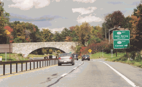
This 2000 photo shows the northbound Taconic State Parkway at NY 301 in Putnam County. Safety improvements in recent years have preserved the design integrity of the parkway through this area. (Photo by Steve Anderson.)
BEYOND THE BERKSHIRE THRUWAY: At the parkway's northern terminus in East Chatham, Columbia County, an interchange was constructed with the Berkshire Thruway (I-90), resulting in a "toll trap."
The "toll trap" had not always been planned this way. Throughout the 1950's, officials at the New York State Department of Public Works (NYSDPW) planned to extend the Taconic State Parkway as far north as US 20 in West Lebanon, Rensselaer County. Some maps show the proposed Taconic Parkway extending as far north as Buskirk (at the intersection of NY 67 and NY 22), on the Rensselaer-Washington county border. (Still earlier plans had the parkway extend as far north as the Canadian border.)
In 1963, a reduction in statewide road construction funds forced state officials to shelve the extension to US 20. Soon thereafter, the East Hudson Parkway Authority established as its northern jurisdictional boundary the Taconic Parkway-Berkshire Thruway toll plaza, thwarting any future extension.
Decades after the Taconic Parkway extension was canceled, graded but unpaved roadway alignments remain at the interchange with the Berkshire Thruway. This evidence of a once-proposed "double-trumpet" interchange remains even after a 1998 New York State Thruway Authority (NYSTA) project added new bridges and ramps to this location.
To improve safety, all remaining at-grade intersections along the Taconic State Parkway should be eliminated. Where appropriate, grade-separated interchanges should be constructed.
The recommended exit numbering scheme for the Sprain Brook Parkway should be continued on the controlled-access sections of the Taconic State Parkway through Westchester, Putnam, and Dutchess counties (and at a later date, into Columbia County).
SOURCES: Reports of the Westchester County Parks Commission (1926-1935), Westchester County Parks Commission (1935); "Taconic Project Put Off by State" by Joseph C. Ingraham, The New York Times (5/21/1963); "New Taconic Link" by Bernard Stengren, The New York Times (11/17/1963); "State Purchases Railroad Route" by Merrill Folsom, The New York Times (7/24/1965); "Kill the Hill! Pave That Grass!" by Paul O'Neil, Life (10/10/1969); Public Works: A Dangerous Trade by Robert Moses, McGraw-Hill (1970); The Power Broker by Robert A. Caro, Vintage Books-Random House (1974); "East Hudson Parkway Authority: Annual Report," East Hudson Parkway Authority (1977); "Pioneering in Parks and Parkways: Westchester County, New York (1895-1945)" by Marilyn E. Weigold, Public Works Historical Society (February 1980); "Taconic State Parkway: Multiple Contexts, Changing Design" by Kathleen LaFrank, New York State Office of Parks, Recreation and Historic Preservation (1998); "Taconic State Parkway Corridor Management Plan" by Patricia M. O'Donnell and Lori Tolliver, National Trust for Historic Preservation (4/08/2000); "Developing the Programmatic Approach between the Two State Agencies" by Philips Crocker and Michael F. Lynch, National Trust for Historic Preservation (4/08/2000); "Taconic Crossing Delays a Slow Go" by Anthony Farmer, The Poughkeepsie Journal (12/02/2000); "Dispute on the Taconic: Safety or Convenience" by Winnie Hu, The New York Times (7/03/2001); "A Strong Trunk and Branches: Granite Construction Builds on a California Base" by Allen Zeyher, Roads and Bridges (September 2003); "Upbeat Forecast for 2004" by Alex Philippidis, Westchester County Business Journal (1/05/2004); New York Metropolitan Transportation Council; New York State Thruway Authority; Rob Adams; Leo Auray; Russ Blau; David J. Greenberger; Ralph Herman; David Jackino; Nick Klissas; John Mara; Dan Moraseski; Mike Moroney; Mike Natale; Nathan W. Perry; Alexander Svirsky; Mike Tantillo; Mark Terribile; Stu Thorn; Douglas A. Willinger.
Taconic State Parkway shield by Ralph Herman. Lightposts by Jeff Saltzman.