 |
|
|
|
|
|
|
|
|
|
|
|
|
|
|
|
|
|
|
|
|
|
|
|
|
|
|
|
|
|
|
|
|
|
|
|
|
|
|
 |
|
 |
|
|
|
|
|
|
|
|
|
|
|
AFTER DECADES IN PLANNING, A DREAM REALIZED: Originally planned by the Westchester County Parks Commission in 1925, the Sprain Brook Parkway was designed to alleviate traffic in the Yonkers-to-Elmsford corridor, and to assist the development of the Grassy Sprain Valley. Included in the parkway proposal was the development of Sprain Ridge Park and Sprain Lake Golf Course, both overlooking Grassy Sprain Reservoir.
The onset of the Great Depression, and later of World War II, delayed construction of the Sprain Brook Parkway. Soon after World War II, congestion to the existing parkways made urgent the need to build new highways, including the Sprain Brook Parkway. The New York State Department of Public Works (NYSDPW) and the Tri-State Transportation Commission recommended this "priority project" as follows:
The Sprain Brook Parkway, a north-south route that has been proposed for decades, will relieve congested, outmoded parallel parkways. It will also provide an interchange with the east-west Cross Westchester Expressway.
During the early 1950's, New York arterial coordinator Robert Moses proposed the Sprain Brook Parkway right-of-way as a possible routing for the New York State Thruway. Moses' Thruway proposal was rejected in favor of a more westerly routing along the Saw Mill River Parkway that advanced by Westchester County and New York State Thruway Authority (NYSTA) officials.
It was not until 1957 - more than three decades after the Sprain Brook Parkway was first proposed - that Moses finally advanced construction of the $47 million, six-lane parkway. The East Hudson Parkway Authority, a newly created state agency that assumed jurisdiction of several parkways from the Westchester County Parks Commission, soon began construction on the parkway.
|
|
|
|
|
|
|
|
|
|
|
|
|
|
 |
|
|
|
|
|
 |
|
|
|
|
|
|
|
|
This 1960 photo shows the Sprain Brook Parkway under construction at the Tuckahoe Road overpass. (Photo by Triborough Bridge and Tunnel Authority.)
|
|
|
|
|
|
|
|
|
|
|
|
|
|
|
|
|
|
THE PARKWAY, SECTION BY SECTION: The Sprain Brook Parkway begins at the Bronx River Parkway, just north of the Cross County Parkway in Mount Vernon. From this point, work began on the parkway in 1958 under the direction of Robert Moses. The first section of the Sprain Brook Parkway, from the southern terminus north to Central Park Avenue (NY 100) in Yonkers, opened in September 1961.
In December 1963, the second section of parkway was completed north to Jackson Avenue in Hastings-on-Hudson. Along this section through Sprain Ridge Park, Grassy Sprain Reservoir serves as the median for the parkway. Northbound traffic travels along the eastern shore of the reservoir, while southbound traffic travels along the reservoir's western shore.
The third section of parkway, from Jackson Avenue north to the Cross Westchester Expressway (I-287) in Elmsford, was completed in November 1969. In the Village of Elmsford, "Sprain Brook Parkway Drive," a local side street, serves as a reminder of the original alignment. Originally planned to end at the Saw Mill River Parkway, the new alignment of the Sprain Brook Parkway was shifted about one-half mile to the east of Saw Mill River Road (NY 9A).
|
|
|
|
|
|
|
|
|
|
|
|
|
|
Under the auspices of the New York State Department of Transportation (NYSDOT), the final 2.7-mile, six-lane segment of the Sprain Brook Parkway, from the Cross Westchester Expressway north to the Taconic State Parkway in Hawthorne, was completed on October 28, 1980 at a cost of $25 million. As the newest parkway segment in the New York metropolitan area, the northernmost section of parkway features bridges with 18-foot clearances to accommodate buses. The completion of the Sprain Brook Parkway helped fuel residential and commercial development in northern Westchester County throughout the 1980's.
|
|
|
|
|
|
|
|
|
|
|
|
|
|
|
|
|
|
Daniel T. Dey, frequent contributor to nycroads.com, submitted the following about one of the overpasses on the parkway:
The high bridge that carries Heatherdell Road over the Sprain Brook Parkway in Ardsley actually has a clearance of 43 feet, six inches. You could drive an off-highway mining truck under it, if trucks were allowed on the parkways. (Not that they should be, of course!)
The lessons learned on the older Westchester parkways were applied to the Sprain Brook Parkway, which benefited from many safety advances such as grade separation, 12-foot-wide lanes, 12-foot-wide shoulders, longer acceleration and deceleration lanes, wider medians, and higher design speeds. When the southernmost section of parkway opened in 1961, it featured modern truss-arm lightposts with mercury fixtures. (The lights on the Sprain Brook Parkway were turned off after the 1974 energy crisis; the lightposts were not removed until the early 1990's.)
According to the NYSDOT, the Sprain Brook Parkway carries approximately 90,000 vehicles per day (AADT) south of I-287, and approximately 70,000 vehicles per day north of I-287.
RECONSTRUCTION EFFORTS: Beginning in the mid-1990's, the NYSDOT rehabilitated the southern ten miles of the Sprain Brook Parkway between the Bronx River Parkway and the Cross Westchester Expressway. The $25 million project, which ended in late 1999, included reconstruction of the mainline parkway, installation of new guardrails and upgrading of the drainage systems. Along the bridges, steel guardrails were replaced with stone walls.
ATTEMPTING TO PROTECT THE BUFFER
When New York State purchased right-of-way during the 1950's and 1960's for the Sprain Brook Parkway, it purchased wooded "buffer zones" to protect residents from nearby parkway noise while providing a scenic view for motorists. For many years, these buffers were shown on county and state maps as "parkway land."
During the 1990's, the NYSDOT auctioned off two parcels of this parkway land in Elmsford as surplus to developers. Local resident and civic associations opposed the NYSDOT land sale, and took their case to the New York State Supreme Court. In 2001, Court ruled that "parkland acquired for the purpose of creating a parkway is not protected from alienation as dedicated parkland." It ruled that the parkland was "an open space buffer to ease the burden of and compensate the neighborhood for noise and pollution from the parkway," and that the NYSDOT had the authority to sell the surplus land.
WHILE PROTECTING MOTORISTS BELOW: Following a wave of rock assaults from overpasses on Westchester parkways, including a fatal rock-throwing incident in April 2004, the NYSDOT installed new eight-foot-high fencing along the Palmer Avenue, Kimball Avenue and Central Avenue overpasses on the Sprain Brook Parkway. More fence installations may follow soon.
|
|
|
|
|
|
|
|
|
|
|
|
|
|
|
 |
|
|
|
|
|
|
|
|
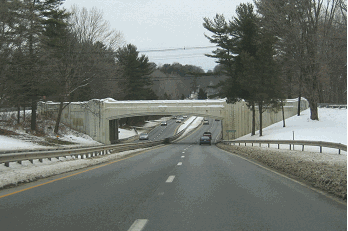
This 1999 photo shows the Sprain Brook Parkway looking north from the NY 100 (Bradhurst Avenue) in Hawthorne. One of the newer routes in the New York metropolitan area, the Sprain Brook Parkway, which was completed in 1980, benefited from decades of advances in highway design. (Photo by Steve Anderson.)
|
|
|
|
|
|
|
|
|
|
|
|
|
|
 |
|
|
|
|
|
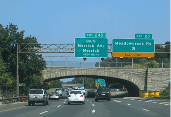
In keeping with New York exit numbering convention, exits on the Sprain Brook Parkway should be numbered sequentially. These exits should be numbered as follows:
JUNCTION: Bronx River Parkway (southern terminus)
EXIT 1: NY 100 (Central Park Avenue)
EXITS 2 E-W: Tuckahoe Road
EXIT 3: Jackson Avenue
EXIT 4: NY 100B (Dobbs Ferry Road)
EXITS 5 E-W: I-287 (Cross Westchester Expressway)
EXIT 6: NY 100C (Grasslands Road)
EXIT 7: NY 100 (Bradhurst Avenue)
JUNCTION: Taconic State Parkway (northern terminus)
|
|
|
|
|
|
|
|
|
|
|
|
 |
|
|
|
|
|
|
|
|
|
|
 |
|
|
|
 |
|
|
|
|
|
SOURCES: Reports of the Westchester County Parks Commission (1926-1935), Westchester County Parks Commission (1935); Parks Department Road Contracts (1934-1974), Westchester County Parks Commission (1974); "Two Parkways in Westchester Will Be Modernized by State," The New York Times (10/18/1961); "Parkway Section Opens at Yonkers," The New York Times (12/24/1963); "Expressway Plans," Regional Plan Association News (May 1964); Arterial Progress 1959-1965, Triborough Bridge and Tunnel Authority (1965); Transportation 1985: A Regional Plan, Tri-State Transportation Commission (1966); "Governor Rockefeller Announces Opening of Parkway Link," The New York Times (11/29/1969); The Power Broker by Robert A. Caro, Vintage Books-Random House (1974); "East Hudson Parkway Authority: Annual Report," East Hudson Parkway Authority (1977); "Pioneering in Parks and Parkways: Westchester County, New York (1895-1945)" by Marilyn E. Weigold, Public Works Historical Society (February 1980); "A Key Westchester Road of 2.7 Miles Opens Today" by Edward Hudson, The New York Times (10/28/1980); Henry Hudson Parkway Task Force; New York State Department of Transportation; Daniel T. Dey; Joel Gultz; Ralph Herman; Nathan W. Perry; Jeff Saltzman; Douglas A. Willinger.
Sprain Brook Parkway shield by Ralph Herman.
|
|
|
|
|
|
|
|
|
|
|
|
|
|
|
|
 |
|
|
|
|
|
|
|
|
|
 |
|
|
|
|
|
|
|
|
|
 |
|
|
|
|
|
THE EXITS OF METRO NEW YORK:
Sprain Brook Parkway exit list by Steve Anderson.
|
|
|
|
|
|
|
|
|
|
|
 |
|
|
|
|
|
VIEW OR SUBMIT YOUR RATING TO RATETHEROADS.COM:
Sprain Brook Parkway
|
|
|
|
|
|
|
|
|
|
|
|
 |
|
|
|
|
|
|
|
|
|
|
|
|
|
|
Site contents © by Eastern Roads. This is not an official site run by a government agency. Recommendations provided on this site are strictly those of the author and contributors, not of any government or corporate entity.
|
|
|
|
|
|
|
|
|
|