
|
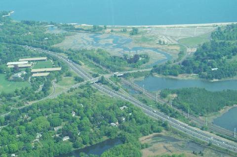
In this 2000 aerial photo, the Sherwood Island Connector is shown at EXIT 18 of the Connecticut Turnpike (I-95) in Westport, looking southeast toward Sherwood Island State Park and Long Island Sound. The Sherwood Island Connector, which also connects to Boston Post Road (US 1), was part of a larger plan for a Sherwood Island Parkway, which was to serve a spur of the Merritt Parkway (CT 15). (Photo by Greg Amy.) |
||
|
MERRITT SPUR AT WESTPORT TO THE SOUND: In 1935, the Merritt Highway Commission, the authority assigned for the design and construction of the Merritt Parkway, published an official map revealing a proposed north-south spur through Westport from the Merritt Parkway to Sherwood Island State Park. The Sherwood Island Parkway was designed not only for recreational purposes, but also to provide an express route from US 1 (Boston Post Road) to the Merritt Parkway. |
||
|
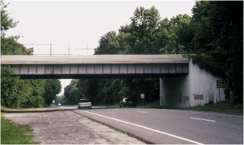
This 2000 photo shows the Sherwood Island Connector at the Hillandale Road overpass, just south of Boston Post Road (US 1) in Westport. Note that the late 1950's-era bridge has additional underclearance for a second carriageway, in anticipation of construction of the controlled-access Sherwood Island Parkway. (Photo by Steve Anderson.) |
||

|
SOURCES: "Expressway Plans," Regional Plan Association News (May 1964); Connecticut Highway Needs, Connecticut Highway Department (1967); Planning for the Future, Connecticut Highway Department (1968); The Merritt Parkway by Bruce Radde, Yale University Press (1993); "Merritt Parkway Cruises to Its 65th Anniversary" by Marian Gail Brown, The Connecticut Post (6/29/2003); Scott Oglesby. |
||
|
SHERWOOD ISLAND PARKWAY LINKS: |
||

|
Back to The Roads of Metro New York home page. |
||
|
Site contents © by Eastern Roads. This is not an official site run by a government agency. Recommendations provided on this site are strictly those of the author and contributors, not of any government or corporate entity. |
||