
|
This 2005 photo shows the northbound Sheridan Expressway (I-895) approaching the overpass for Westchester Avenue. The reconstruction project along this section was just completed when this photo was taken. (Photo by Alex Nitzman, www.aaroads.com.) |
||

|
PLANNING, DESIGN, AND CONSTRUCTION: In 1941, the New York City Planning Department proposed a short expressway spur connecting the "Bronx Crosstown Highway" (Cross Bronx Expressway) to the north with the "Southern Boulevard Express Highway" (Bruckner Expressway) to the south. The proposed expressway was to serve vehicles that could not travel on the Bronx River Parkway, whose extension into the Bronx was in the design stages at the time. |
||
|
Four years later, when he developed the city's postwar arterial development program, New York City arterial coordinator Robert Moses proposed a "Bronx River Expressway" along roughly the same route. The proposed expressway was renamed after Arthur V. Sheridan, the chief engineer of Bronx Borough President James J. Lyons and a staunch ally of Moses who was killed in an automobile accident, in 1956. |
||
|
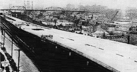
An elevated section of the Sheridan Expressway (I-895) awaits completion in this 1962 photo. (Photo by Triborough Bridge and Tunnel Authority.) |
||
|
REBUILDING THE SHERIDAN: In 1998, the New York State Department of Transportation (NYSDOT) announced a long-range safety and operational improvement plan to better serve the approximately 45,000 vehicles that use the expressway each day. The multi-year project, which began in 2001, included the following improvements: |
||
|
The $200 million Sheridan Expressway reconstruction project was completed in 2005. During reconstruction, roadway capacity is being reduced to one lane in each direction. LONG-RANGE PLANS: State and city officials have considered the following long-term plans for future construction:
|
||
|
EXPRESSWAY TO BE CONVERTED INTO PARK? Beginning in the late 1990's, anti-highway groups pressured local and state officials to have the Sheridan Expressway demolished and converted into a 28-acre riverfront park. Since it was not extended to connect with the Bronx River Parkway and the New England Thruway, the Sheridan Expressway has fallen short of traffic projections. In addition to demolishing the expressway, these groups are seeking transit alternatives for the area. |
||
|
Countering these protests, Peter King, planning and development supervisor for the NYSDOT, defended the agency's decision to upgrade the expressway as follows: |
||
|
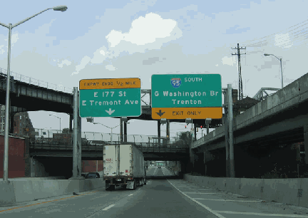
This 1998 photo shows the northern termimus of the Sheridan Expressway (I-895) at the Cross Bronx Expressway (I-95). Original plans called for the Sheridan Expressway to be extended north to the New England Thruway (I-95), in the area of Co-Op City. (Photo by Steve Anderson.) |
||

|
THE SHERIDAN EXTENSION: The proposed extension of the Sheridan Expressway actually derived from a 1941 plan to convert a section of nearby Boston Post Road (US 1) between Pelham Parkway and the city line into an expressway. The plan was described as follows: |
||
|
In 1945, Moses called for a combination of "Bronx River" and "Boston Road" express highways from the city's earlier plan into a unified route. A decade later, the Joint Study of Arterial Facilities, a joint effort of various planning agencies that Moses headed, advocated swift construction of the route. The Federal Bureau of Public Roads (BPR) added the entire length of the route - from the Bruckner Expressway to the New England Thruway - to the proposed Interstate highway network. |
||

|
ON EXTENDING--NOT REMOVING--THE EXPRESSWAY: The Sheridan Expressway should be extended south along Edgewater Road to the Hunts Point Market. The extension would take truck traffic off local roads, improving both traffic circulation and air quality, while the demolition alternative would worsen congestion on the Bruckner and Major Deegan expressways, as well as local roads. Moreover, the removal of the Sheridan Expressway likely would hasten a move of the wholesale produce business away from the Hunts Point Market to New Jersey, where better access to highways would be a key selling point for the move. For these reasons, any plan to tear down the Sheridan Expressway thus would be a non-starter, and the NYSDOT should reconsider plans to extend the expressway north along East 177th Street to the Bronx River Parkway to remove a bottleneck on the Cross Bronx Expressway. |
||
|
One of the arguments for removing the expressway is that it is aesthetically unpleasant, and that turning the right-of-way into a park would remedy this. However, there is no mention of removing the Metro-North tracks, which share the right-of-way with the Sheridan Expressway, and forms just as much as a barrier between the Bronx River and nearby communities. |
||

|
SOURCES: "Master Plan: Express Highways, Parkways and Major Streets," New York City Planning Department (1941); Joint Study of Arterial Facilities, The Port of New York Authority and the Triborough Bridge and Tunnel Authority (1955); "Expressway Named in Honor of Sheridan," The New York Times (8/21/1956); "Elevated Road To Open in the Bronx," The New York Times (10/14/1962); Arterial Progress 1959-1965, Triborough Bridge and Tunnel Authority (1965); Transportation 1985: A Regional Plan, Tri-State Transportation Commission (1966); "Lower Manhattan Road Killed Under State Plan" by Francis X. Clines, The New York Times (3/25/1971); The Power Broker by Robert A. Caro, Vintage Books-Random House (1974); "Dreaming of a Park on the Sheridan Expressway" by Heather McRea, The Bronx Beat (4/05/1999); "Exit Strategies" by Clara Hemphill, Newsday (10/03/1999); "Boondoggle Highway: $420 Million for Highway to Nowhere" by Tom Topousis, New York Post (10/02/2000); "Hunts Point Growing Pains" by Bill Egbert, New York Daily News (3/17/2002); "Bruckner-Sheridan Interchange and Commercial Access to Hunts Point Peninsula," New York State Department of Transportation (2002); 13 Projects for the Sheridan Expressway by Jonathan D. Solomon, Princeton Architectural Press (2004); "New Jersey Lures Hunts Point Market" by Meredith Melnick, New York Daily News (12/10/2008); "Local Traffic Would Worsen Without Sheridan, Study Shows" by Sam Dolnick, The New York Times (7/13/2010); "End of Sheridan: The Great Highway Unbuilders of the Bronx" by Katharine Jose, CapitalNewYork.com (10/20/2010); New York Metropolitan Transportation Council; Tri-State Transportation Campaign; Daniel T. Dey; David J. Greenberger; Ralph Herman; Scott Oglesby; Jeff Saltzman; Tom Scannello; Stephen Summers; Douglas A. Willinger. |
||

|
SHERIDAN EXPRESSWAY LINKS: |
||
|
SHERIDAN EXPRESSWAY VIDEO LINK: |
||
|
SHERIDAN EXPRESSWAY CURRENT CONDITIONS: |
||

|
THE EXITS OF METRO NEW YORK: |
||
|
VIEW OR SUBMIT YOUR RATING TO RATETHEROADS.COM: |
||

|
Back to The Roads of Metro New York home page. |
||
|
Site contents © by Eastern Roads. This is not an official site run by a government agency. Recommendations provided on this site are strictly those of the author and contributors, not of any government or corporate entity. |
||