 |
|
|
|
|
|
|
|
|
|
|
|
|
|
|
|
|
|
|
|
|
|
|
|
|
|
|
|
|
|
|
|
|
|
|
|
|
|
|
|
|
|
|
|
|
 |
|
 |
|
|
|
|
|
|
|
 |
|
|
|
|
|
PARKWAY TO THE GARDEN SUBURB: When it was proposed by the Westchester County Parks Commission plan in 1924, the Saw Mill River Parkway was promoted as "a key project in the creation of the garden suburb." The parkway was to be modeled after the Bronx River Parkway, which had just been completed a few miles to the east. Like many Westchester parkways of the 1920's and 1930's, the Saw Mill River Parkway is a hybrid limited-access highway, with at-grade intersections in some locations. Decorative stone arch bridges are used for grade separations.
|
|
|
|
|
|
|
|
|
|
|
|
|
|
From a planning standpoint, the Saw Mill River Parkway was important because it included the construction of a trunk sewer without which the water supply of Yonkers would have become contaminated. The Westchester County Parks Commission also stated that parkway project would help prevent flooding in the Saw Mill River valley.
The first section of the parkway, a short bypass of downtown Yonkers, was completed in 1926. Extending the parkway north and south posed challenges. South of Yonkers, agreements had to be reach in order to connect the Saw Mill River Parkway with a proposed Henry Hudson Parkway in the Bronx. North of Yonkers, the original route of the parkway had to be revised in order to avoid an industrial area. To accomplish this, the Saw Mill River was diverted to a new channel west of the New York Central Railroad's Putnam Division tracks. This newly revised route went through a heavily wooded area, enhancing the scenic value of the parkway.
EXTENDING THE PARKWAY: The next four-mile section of the parkway, from Tuckahoe Road in Yonkers to Ashford Avenue in Dobbs Ferry, was completed in September 1929. Another four-mile section, between Dobbs Feery and NY 119 (Tarrytown Road) in Elmsford, was completed in 1930. This second section entailed considerable grading and the construction of two bridges across the Saw Mill River. When this section was completed, rights-of-way were set aside for an interchange with the Central Westchester Parkway (which later evolved into the Cross Westchester Expressway).
|
|
|
|
|
|
|
|
|
|
|
|
|
|
|
|
|
The original plans called for the Saw Mill River Parkway to end at a park along the shores of the New Croton Reservoir in Katonah. Grading began on the 20-mile-long, Elmsford-to-Katonah section in the mid-1930's. The parkway was extended north to Chappaqua in 1940, but World War II delayed completion of the parkway to Katonah (NY 22-NY 35-NY 117) until 1954. When it was completed, the parkway simply merged into the existing NY 22. In 1970, new ramps were constructed to tie the parkway into I-684, which was being constructed along the NY 22 right-of-way through Katonah.
|
|
|
|
|
|
|
|
|
|
|
|
|
|
|
|
|
|
WIDENING PLANS THWARTED: In 1955, Westchester County proposed a $61 million plan to bring the parkways up to modern design standards. The following design changes were to be made to the Saw Mill River Parkway:
The parkway was to be widened to eight lanes from the Bronx-Westchester border north to the Cross Westchester Expressway (I-287). This widening was to be facilitated by the subsequent purchase of the 22-mile-long New York Central Railroad-Putnam Division right-of-way in 1958. Eventually, the parkway was to be widened to ten lanes.
There was also a plan to remove the existing grade-level intersections and traffic signals from the parkway at Executive Boulevard, Hearst Street, Tompkins Avenue, Farragut Parkway and Lawrence Street.
Both plans were met with significant resistance from community groups in Yonkers, Hastings-on-Hudson and Dobbs Ferry.
|
|
|
|
|
|
|
|
|
|
|
 |
|
|
|
|
 |
|
 |
|
|
|
|
|
|
|
|
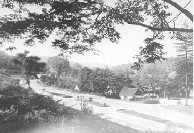
LEFT: This photo shows the Yonkers gas station along the Saw Mill River Parkway in the late 1920's. (Photo by Library of Congress, Prints and Photographs Division, LC-119875.)
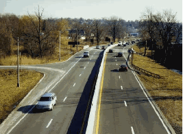
RIGHT: The Saw Mill River Parkway circa 1960, before the median barrier was installed. (Postcard supplied by James Rumbarger.)
|
|
|
|
|
|
|
|
|
|
|
|
|
|
|
|
|
|
|
|
DESIGN CHANGES: The widening plans of the 1950's and 1960's were never implemented, but a number of measures have been undertaken to improve safety and traffic flow on the Saw Mill River Parkway in the decades since then. The East Hudson Parkway Authority undertook these measures throughout the 1960's and 1970's.
The most notable of the changes by the East Hudson Parkway Authority was the construction of the $25 million three-level "half-stack" interchange with the Taconic State Parkway (EXIT 26) between 1969 and 1972. The interchange, which has crossover ramps on the center level, provides only parallel connections (i.e., north-to-north, south-to-south); reverse connections are not provided. It replaced the dangerous "Hawthorne Circle" at this location.
|
|
|
|
|
|
|
|
|
|
|
|
|
|
Since 1980, the New York State Department of Transportation (NYSDOT) has maintained the Saw Mill River Parkway. Under the NYSDOT, the 25-cent toll between EXIT 3 (McLean Avenue) and EXIT 4 (Cross County Parkway), which was originally implemented by Westchester County in 1936, was removed on October 31, 1994. More recently, the NYSDOT narrowed the parkway from six lanes to four lanes (two lanes in each direction), added shoulders, lengthened acceleration-deceleration lanes, and improved sight lines.
Although overshadowed by more modern parallel highways, the Saw Mill River Parkway continues to serve as an north-south artery, carrying approximately 60,000 vehicles per day (AADT) from the Bronx-Westchester border north to the Cross Westchester Expressway (I-287), and approximately 35,000 vehicles per day from I-287 north to I-684.
CURRENT AND FUTURE IMPROVEMENTS: During 2003, the NYSDOT eliminated the unsignalized crossroads at EXIT 19 (Everett Macy Park) in Arsdley and EXIT 38 (Green Lane) in Bedford Hills to improve safety.
The NYSDOT and the New York Metropolitan Transportation Council (NYMTC) scheduled the following improvements along the Saw Mill River Parkway during the next several years:
From EXIT 17 (Ashford Avenue) in Dobbs Ferry north to EXIT 22 (I-287 / Cross Westchester Expressway) in Elmsford, parkway rehabilitation is expected to continue through 2009. This project, which includes pavement rehabilitation, new shoulders, and other safety and drainage improvements, is expected to cost $23 million.
Along with the Army Corp of Engineers, the NYSDOT is studying ways to alleviate chronic flooding between EXIT 27 (Marble Avenue) and EXIT 29 (Manville Road). Local engineer Fred Haetinger proposed building a 200-foot-long levee at the spot of the worst flooding. Although the levee could be erected quickly, officials are concerned that the levee would push floodwaters elsewhere. The NYSDOT also may consider raising the parkway above the water table, a plan that was not received well by Pleasantville officials when it was last proposed in 1993.
From EXIT 32 (NY 120) in Chappaqua north to the northern terminus at I-684 in Katonah, parkway rehabilitation is expected to continue through 2011. This project, which includes rehabilitating the main roadways, constructing new shoulders and making other structural upgrades along the parkway, and constructing a new bridge for the Catskill Aqueduct over the parkway, is expected to cost $9 million.
THE ABANDONED: For two decades, two abandoned service stations designed by landscape architect (and former Westchester parks commissioner) Gilmore Clark have stood vacant along the parkway in Hastings-on Hudson. The rustic-style stations, which were built in the 1930's of stone and cedar with sloping, shingled roofs, have been proposed for a variety of purposes since they closed in 1980. Tearing them down would require permission from the New York State Historic Preservation Office.
Meanwhile, the abandoned New York Central Railroad-Putnam Division right-of-way, which last saw passenger service in 1958 and freight service in 1980, was converted into a pedestrian and cycling trail. Part of the right-of-way was incorporated into a nature trail in Van Cortlandt Park.
|
|
|
|
|
|
|
|
|
|
|
|
|
|
 |
|
 |
|
|
|
|
|
|
|
|
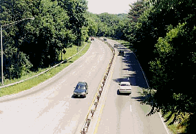
Two 1998 views of the Saw Mill River Parkway. LEFT: Looking south on the Saw Mill River Parkway from the Odell Avenue overpass in Yonkers. (Photo by Steve Anderson.) RIGHT: Looking north on the Saw Mill River Parkway in Ardsley. (Photo by Jeff Saltzman.)
|
|
|
|
|
|
|
|
|
 |
|
|
|
|
 |
|
|
|
|
|
RAISE THE PARKWAY: The Saw Mill River Parkway should be raised through Pleasantville. This work, which could be done in conjunction with a new grade-separated interchange at EXIT 27 (Marble Avenue) in Pleasantville, should be done in a context-sensitive fashion (e.g., stone barriers) while adhering to modern design standards.
|
|
|
|
|
|
|
|
|
|
|
|
|
|
|
|
|
|
|
|
|
 |
|
|
|
 |
|
|
|
|
|
SOURCES: "Westchester Park Plan Likely To Win," The New York Times (1/10/1926); Reports of the Westchester County Parks Commission (1926-1935), Westchester County Parks Commission (1935); "Westchester Gets Parkway Plans" by Merrill Folsom, The New York Times (1/18/1955); "State Purchases Railroad Route" by Merrill Folsom, The New York Times (7/24/1965); "Kill the Hill! Pave That Grass!" by Paul O'Neil, Life (10/10/1969); The Power Broker by Robert A. Caro, Vintage Books-Random House (1974); "East Hudson Parkway Authority: Annual Report," East Hudson Parkway Authority (1977); "Pioneering in Parks and Parkways: Westchester County, New York (1895-1945)" by Marilyn E. Weigold, Public Works Historical Society (February 1980); "Parkway Designs" by Edward Hudson, The New York Times (12/01/1985); "A Call for Saw Mill Proposals" by Joseph P. Griffith, The New York Times (9/16/1990); "The Tracks Are Gone" by John W. Farrell, The New York Times (1/18/1998); "Floods Beset Road, Pleasantville Mayor" by Shawn Cohen, The Journal-News (12/30/2005); "Levee Proposed for Saw Mill River Parkway," WINS Radio (12/30/2005); New York Metropolitan Transportation Council; Jane Daniels; Ralph Herman; Nathan W. Perry; Jeff Saltzman; Alexander Svirsky; Mike Tantillo; Mark Terribile; Otto Vondrak; Douglas A. Willinger; Rob Yasinac.
Saw Mill River Parkway shield by Ralph Herman.
Lightposts by Jeff Saltzman.
|
|
|
|
|
|
|
|
|
|
|
|
|
|
|
|
 |
|
|
|
|
|
|
|
|
|
 |
|
|
|
|
|
|
|
|
|
 |
|
|
|
|
|
THE EXITS OF METRO NEW YORK:
Saw Mill River Parkway exit list by Steve Anderson.
|
|
|
|
|
|
|
|
|
|
|
 |
|
|
|
|
|
|
|
|
|
 |
|
|
|
|
|
|
|
|
|
|
|
|
|
|
Site contents © by Eastern Roads. This is not an official site run by a government agency. Recommendations provided on this site are strictly those of the author and contributors, not of any government or corporate entity.
|
|
|
|
|
|
|
|
|
|