

|
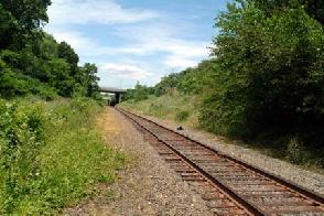
These 2004 photos show the New York Connecting Railroad at Metropolitan Avenue in Middle Village (left photo), and at 57th Avenue in Elmhurst (right photo). The right-of-way for the freight line was to be used for the Queens-Interboro Expressway (I-695). Photos by Kevin Walsh, www.forgotten-ny.com.) |
||

|
THE 1941 PLAN: First proposed by the New York City Planning Department in 1941, the Queens-Interboro Expressway was to connect southern Brooklyn with the Triborough and Bronx-Whitestone bridges. Combined with the Cross Brooklyn Expressway, it was to be part of a circumferential route for traffic seeking to bypass Manhattan. |
||
|
Middle Brooklyn-Queens Highway: This highway would form part of a circumferential route through the middle of Brooklyn and Queens. At its northerly end, it connects with the Grand Central Parkway via the Brooklyn-Queens Connecting Highway (Expressway). At its southerly end, it connects with the Belt Parkway system at Canarsie via the proposed Canarsie Connection, and at Owl's Head via the proposed Cross Brooklyn Express Highway (Expressway). It is proposed that the route be located over or in the vicinity of the New York Connecting Railroad. At this location, a minimum of grade separating structures would be required, since it would not be necessary to make provision for the crossing of streets that are already cut off by the railroad. It would tend to strengthen the industrial areas served by the railroad by providing them with express service for trucks. Preliminary studies by the Planning Department indicate that the cost of this improvement from the Connecting Highway at Roosevelt Avenue to the proposed Cross Brooklyn Express Highway at Linden Boulevard would be about $21,000,000. |
||
|
THE 1967 PLAN: According to 1967 state and city plans, the Queens-Interboro Expressway was to become the northern extension of the Cross Brooklyn Expressway. The "QIE" designation was to begin at the never-built interchange between the Cross Brooklyn Expressway, Bushwick Expressway and Jackie Robinson (Interborough) Parkway in East New York, Brooklyn. It was to continue north along the New York Connecting Railroad (now a freight line used by the LIRR) to the intersection of the Brooklyn-Queens Expressway (I-278) and Northern Boulevard (NY 25A) in Woodside, Queens. The combined Queens Interboro and Cross Brooklyn expressways were to serve as a north-south relief route for the Brooklyn-Queens, Gowanus and Van Wyck expressways. |
||
|
THE 1969 PLAN: In December 1969, the proposed route of the Queens-Interboro Expressway was revised to one similarly proposed in 1941. Under the new proposal, the expressway was to begin at the Belt Parkway near Pennsylvania Avenue in the Starrett City section of Brooklyn. Between Flatlands Avenue and Linden Boulevard (NY 27), two east-west expressways were to meet the Queens-Interboro Expressway. The first, the Nassau Expressway Extension (I-878), was to intersect near Flatlands Avenue. A second "future east-west expressway," the Cross Brooklyn Expressway (redesignated as I-878), was to split off from the Queens-Interboro Expressway near Linden Boulevard. North of Linden Boulevard, the "QIE" was to continue north along the route of the New York Connecting Railroad to its northern terminus at the "BQE" (I-278) in Woodside. |
||
|
Under this plan, no provision was made for the Bushwick Expressway (I-78), an expressway that Robert Moses fought for, but the city opposed and ultimately killed. The Federal government approved the new I-695 designation for the Queens Interboro route in 1970 (the state had listed this expressway as an unmarked state route as a prior to that time). |
||

|
The Queens-Interboro Expressway was to have four lanes between the Belt Parkway and Nassau Expressway Extension, eight lanes between the Nassau Expressway Extension and the Jackie Robinson Parkway, and six lanes between the Jackie Robinson Parkway and the Brooklyn-Queens Expressway. With this scheme, the "QIE" was to have a design capacity of 130,000 vehicles per day (AADT). In addition, allowances were to be made in the center median for a dual-track relocation of the L subway (Canarsie BMT) line from its existing elevated structure in Brooklyn, as well as for continuation of the freight rail line in the center median through Brooklyn and Queens. |
||
|
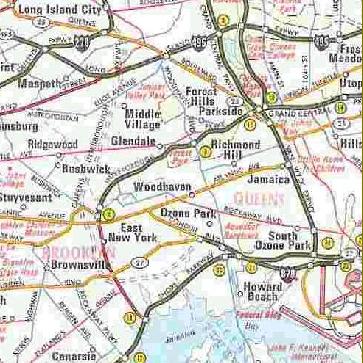
This scan shows a 1971 map plotting the route of the Queens-Interboro Expressway. No route designation was shown on this map, but official documents show the route as I-695. Note how the alignment on this map turns east along Linden Boulevard toward Conduit Boulevard and the Nassau Expressway. (Map © 1971 by Diversified Map Company; scanned by Daniel T. Dey.) |
||
|
The benefits of the Queens Interboro Expressway were stated in the Vollmer Associates consulting report as follows: |
||
|
The total cost of the 10.5-mile Queens Interboro Expressway was estimated at $322 million (1973 dollars), with an additional $52 million allocated for land acquisition. As part of the right-of-way acquisition, the expressway would have required relocation of 40 families in Queens and 471 families in Brooklyn. Completion of the expressway was scheduled for 1980. TOO LITTLE, TOO LATE? Even with the attention paid to mass transit and community development issues in the proposal, community opposition was strident, particularly in the Queens communities through which the expressway was to pass. By the end of 1973, officials permanently shelved the Queens Interboro Expressway proposal. Soon thereafter, Interstate highway funds were transferred to the Westway (I-478) project and other upstate projects. In 1986, the New York State Department of Transportation (NYSDOT) transferred the I-695 designation to the Throgs Neck Expressway in the Bronx. |
||

|
SOURCES: "Master Plan: Express Highways, Parkways and Major Streets," New York City Planning Commission (1941); Joint Study of Arterial Facilities, The Port of New York Authority and the Triborough Bridge and Tunnel Authority (1955); Arterial Progress 1959-1965, Triborough Bridge and Tunnel Authority (1965); "Linear City and Cross Brooklyn Expressway: Plan for Planning Report," Rogers, Taliaferro, Kostritsky and Lamb (1967); "US Agrees To Aid Lindsay Proposal for Linear City" by Richard Madden, The New York Times (6/29/1968); "Description of Touring Routes in New York State for the Interstate, Federal, and State Route Number Systems," New York State Department of Transportation (1970); "Queens Interborough Expressway: Planning Report," Vollmer Associates (1973); "Highway Hopes That Faded by Sidney C. Schaer, Newsday (11/05/1999); David Golub; Ralph Herman; Scott Oglesby; Tom Scannello; Kevin Walsh. |
||
|
QUEENS INTERBORO EXPRESSWAY LINKS: |
||

|
Back to The Roads of Metro New York home page. |
||
|
Site contents © by Eastern Roads. This is not an official site run by a government agency. Recommendations provided on this site are strictly those of the author and contributors, not of any government or corporate entity. |
||