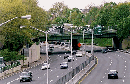
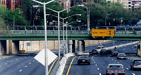
This 1998 photo shows the westbound Prospect Expressway (NY 27) at EXIT 3 (8th Avenue / 7th Avenue) in Brooklyn. (Photo by Jeff Saltzman.)
LINKING CENTRAL BROOKLYN WITH THE BATTERY TUNNEL: The Prospect Expressway, which links central Brooklyn with the I-278 and the Brooklyn-Battery Tunnel (I-478), marks the beginning of the 120-mile-long Route 27. The six-lane limited-access route with flanking service roads runs parallel to Prospect Avenue, ending at Ocean Parkway (an at-grade surface boulevard) just southwest of Prospect Park. The route of NY 27 continues east through Brooklyn along Linden Boulevard.
The expressway was first proposed in 1941 by the New York City Planning Department as follows:
Hamilton Avenue-Ocean Parkway Connection: This is an essential part of the approach highway system for the Brooklyn-Battery Tunnel, connecting the tunnel with Ocean Parkway. If the city is to realize the full benefits of the tunnel, adequate approach highways must be provided for it. Preliminary study by the Planning Department indicates that the cost of the improvement would be about $12,500,000.
In 1944, the New York State Department of Public Works (NYSDPW) added the Prospect Expressway to its postwar construction program, and one year later, Robert Moses, the arterial coordinator for New York City, added the route to the city's postwar program.
Construction of the Prospect Expressway began in 1953 at the junction of the Gowanus Expressway. The expressway was mostly complete by 1960, with the exception of the interchange at Fort Hamilton Parkway and Ocean Parkway. Two years later, this interchange was completed. The 2.1-mile-long Prospect Expressway took nine years and $28 million to construct.
RECONSTRUCTION EFFORTS AND CURRENT DEVEOPMENTS: In 1995, the New York State Department of Transportation (NYSDOT) embarked on a project to reconstruct the Prospect Expressway. This project, which included the construction of new roadways, shoulders, bridges, lighting and signs, the implementation of a motorist information system (including variable message signs), and the improvement of the expressway's acceleration and deceleration lanes, was completed in 1998 at a cost of $80 million.
During the late 1990's, the Regional Plan Association (RPA) advanced a proposal to place the nearby Gowanus Expressway (I-278) through a new tunnel. Once the Gowanus Tunnel is constructed, the existing elevated structure would be torn down. However, motorists traveling between the Prospect Expressway and points north would not enter the tunnel, but rather use the existing at-grade Hamilton Avenue. The $2.4 billion proposal would create new opportunities for waterfront esplanades and parks in Brooklyn. However, the NYSDOT favors a less costly rehabilitation of the existing Gowanus Expressway and the Prospect Expressway interchange.
According to the NYSDOT, the Prospect Expressway handles approximately 85,000 vehicles per day (AADT).
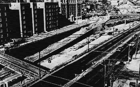
Construction progresses on the Prospect Expressway in this 1959 photo. (Photo by Triborough Bridge and Tunnel Authority.)
FOLLOWING ROUTE 27 THROUGH BROOKLYN: Continuing east from the terminus of the Prospect Expressway, nycroads.com contributor Ralph Herman described the routing for NY 27 through Brooklyn in misc.transport.road as follows:
Technically, the NY 27 routing at the eastern (southern) end of the Prospect Expressway continues east on Church Avenue, north on Coney Island Avenue, then east again on Caton Avenue to Linden Boulevard.
However, no turns are permitted from the eastbound Prospect Expressway to Church Avenue, so NY 27 eastbound routing continues south on Ocean Parkway to Beverly Road (the first legal left turn past Church Avenue), then left again to Coney Island Avenue.
It does not stop there: trucks are not permitted on Ocean Parkway. To continue east on NY 27, trucks must use a ramp just before Church Avenue to the Ocean Parkway service road. Therefore, TRUCK NY 27 east exits at the Fort Hamilton Parkway exit and continues on local streets: East 5th Street to Church Avenue, then east on Church Avenue to rejoin NY 27 as it crosses Ocean Parkway.
During 1976, when NYSDOT did a citywide route marker replacement project, the eastbound NY 27 routing was marked using Ocean Parkway, Beverly Road, Coney Island Avenue and Caton Avenue. (For westbound NY 27, the route is Caton Avenue to Coney Island Avenue to Church Avenue to the Prospect Expressway.)
Local residents objected initially to eastbound NY 27 routing on Beverly Road, but more importantly, the mainline of Ocean Parkway is restricted to passenger car traffic only. That is why a short time later, the NYCDOT placed TRUCK NY 27 markers at the Fort Hamilton Parkway (currently renamed Park Circle) exit, since left turns are prohibited at Church Avenue from the eastbound (southbound) Prospect Expressway. Commercial traffic was now directed to exit before Church Avenue for East 5th Street / Caton Avenue for routing to Linden Boulevard. I believed this was not officially NYSDOT sanctioned, but apparently the "official" eastbound NY 27 routing had been changed. Why the NYCDOT continued to mark the Fort Hamilton Parkway exit "TRUCK NY 27" through the 1980's is beyond me.
If you look at a map, of course the East 5th Street / Caton Avenue routing is the most direct to Linden Boulevard, but once again local community opposition changed the TRUCK NY 27 route. After a series of serious truck accidents using the Fort Hamilton Parkway exit (due to a weaving pattern for exit ramp traffic to access East 5th Street), the NYSDOT moved the primary routing to Park Circle / East 5th Street / Caton Avenue, and the truck routing to the 10th Avenue exit (to minimize the weaving across the service road at the Park Circle ramp.
There is another minor point about the east TRUCK NY 27 routing. NYCDOT installed the TRUCK NY 27 route markers from the Prospect Expressway a few years after the revised NY 27 markers were installed on the Prospect Expressway in Brooklyn. It was one of the few instances where NYCDOT crews installed MUTCD type route marker assemblies. (Usually, instead of using route market assemblies, NYCDOT usually places route shields on guide signs with the name of the route.)
Nathan Perry, webmaster of the "Empire State Roads" site, provided some additional answers from the NYSDOT route log as follows:
The Prospect Expressway is a state-maintained highway bearing reference number NY 27. We all know that reference numbers often differ from posted Touring Route numbers. Therefore, it is not surprising that the TMM's end at Church Street, indicating simply that this is the end of state-maintained NY 27 and meant to give no indication of further routing of Touring Route NY 27.
The surface streets that carry the NY 27 designation are not maintained by the state, but merely signed as a state Touring Route. Therefore, these routes do not have TMM's posted.
We are dealing with two slightly different levels of state route identification that usually agree. This is one situation where there is a discrepancy. Our confusion arises from being privy to that extra level, of which the public is not generally aware.
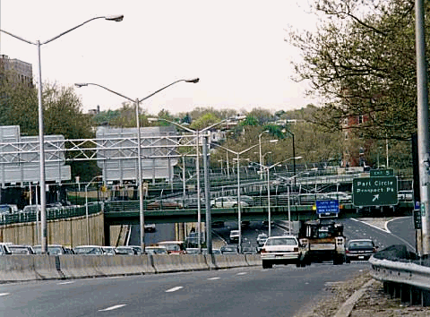
This 1998 photo shows the eastbound Prospect Expressway (NY 27) at EXIT 5 (Park Circle)near Prospect Park in Brooklyn. (Photo by Jeff Saltzman.)
AN EXTENSION TO SOUTHERN BROOKLYN: Plans to extend the Prospect Expressway were revived in the 1960's. In 1963, New York City Arterial Coordinator Robert Moses proposed a $10.5 million conversion of the existing Ocean Parkway into an expressway. The 4.2-mile-long project, would have provided a six-lane expressway with flanking service roads between Prospect Park and Coney Island. Future connections were to be provided with the east-west Cross Brooklyn Expressway.
In its 1966 report Transportation 1985: A Regional Plan, the Tri-State Transportation Commission recommended a Prospect Expressway extension along a different route, along Flatbush Avenue southeast to the Marine Parkway-Gil Hodges Memorial Bridge. The Commission stated the purpose and benefits of the Prospect Expressway extension as follows:
The proposed Prospect Expressway Extension, a north-south route through Brooklyn to the Rockaways, will fill the need for highway access in a large, unserved area. It will extend an existing stub-end route, better utilizing existing capacity. When completed, it will assist in the development of industrial sites in Brooklyn and recreational areas in the Rockaways.
Both expressway proposals were scheduled for completion by 1975. However, in the wake of disruption caused by expressway construction elsewhere in New York City, neither proposal to extend the Prospect Expressway was approved. With the departure of Robert Moses from his official posts in the late 1960's, attention shifted toward improving transit in the region.
"End of the road" for the Prospect Expressway in this 1998 photo, just before it becomes Ocean Parkway in the Prospect Park section of Brooklyn. (Photo by Jeff Saltzman.)
If the Gowanus Expressway Tunnel is built, direct access to and from the Prospect Expressway should be provided for a seamless, controlled-access route from central Brooklyn to points north.
SOURCES: "Master Plan: Express Highways, Parkways and Major Streets," New York City Planning Department (1941); "Prospect Avenue Expressway," New York State Department of Public Works (1944); Joint Study of Arterial Facilities, The Port of New York Authority and the Triborough Bridge and Tunnel Authority (1955); "Prospect Expressway Link To Open," The New York Times (6/11/1962); Arterial Progress 1959-1965, Triborough Bridge and Tunnel Authority (1965); Transportation 1985: A Regional Plan, Tri-State Transportation Commission (1966); "ITS and Construction: A Perfect Match in New York City" by R. E. Bockstruck and James F. Caffrey, Intelligent Transportation Society of New York (1997); "Gowanus Expressway" by Carlos Restrepo, Institute for Civil Infrastructure Systems (2000); New York State Department of Transportation; David J. Greenberger; Ralph Herman; Hal Koplin; Nathan W. Perry; Jeff Saltzman.
NY 27 and I-278 shields by Ralph Herman. Lightposts by Jeff Saltzman.