
|
|
||
|
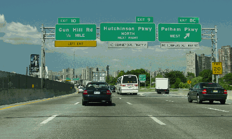
This 2002 photo shows the beginning of the northbound New England Thruway (I-95) in the Co-Op City section of the Bronx. The New England Thruway continues the route of the Bruckner Expressway north into Westchester County. (Photo by Jim K. Georges.) |
||
|
Length: |
||
|
15.3 miles (24.6 kilometers) |
||
|
Passenger car cash toll (northbound only): |
||
|
$1.75 |
||
|
|
||

|
EARLY PLANNING ON THE CORRIDOR: According to Hugh Pomeroy, chief planner for the Westchester County Planning Commission, the New England Thruway was to be a controlled-access route along the Hutchinson River Parkway-US 1 ("New England") corridor. The route of the New England Thruway was to be on the northerly side of the New York and New Haven Railroad (now the Amtrak-Metro North New Haven rail line), along land acquired by Westchester County in the late 1920's for the never-built Pelham-Port Chester Parkway. |
||
|
From The New York Times: |
||
|
The new route is approximately 15 miles long and parallels the New Haven Railroad. It joins the Boston Post Road at the Connecticut state line near the Merritt Parkway to the north, and with Eastern (Bruckner) Boulevard and the new Hutchinson River Parkway Extension, forming corridors to the Triborough, Bronx-Whitestone and other bridges to the south. The express highway for mixed traffic should be built for three lanes in each direction, with grade crossings eliminated by 49 bridges and five viaducts. |
||
|
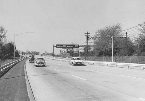
This 1959 photo shows the northbound New England Thruway (I-95) at EXIT 15 (US 1) in New Rochelle. (Photo by New York State Thruway Authority via Todd Berkun. |
||

|
THE THRUWAY AUTHORITY TAKES OVER
In 1950, the New York State Legislature approved construction of the New England Thruway, and placed jurisdiction over the road to the New York State Thruway Authority (NYSTA). The following year, the NYSTA decided to construct a barrier toll plaza in Larchmont to finance the thruway. Much of the right-of-way for the project already had been acquired for the unbuilt Pelham-Port Chester Parkway project, except for a 1½ -mile-long section through Larchmont. |
||
|
BUT STIRS CONTROVERSY: The project required the demolition of the Larchmont railroad station and nearby businesses, raising the ire of Patrick B. McGinnis, the president of the New Haven Railroad. The NYSTA compensated by building a multi-million dollar parking lot and railroad station above the proposed highway, but even this did not please McGinnis, who said, "Why should the people of Larchmont agree to anything that makes them climb steps?" Construction of the elevated station and parking lot required the closure of Chatsworth Avenue for nearly a year. |
||
|
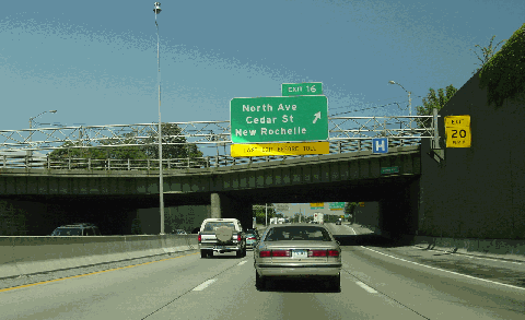
This 2002 photo shows the northbound New England Thruway (I-95) at EXIT 16 (North Avenue) in New Rochelle. (Photo by Jim K. Georges.) |
||
|
THE NEW ENGLAND THRUWAY OPENS: On October 15, 1958, Governor Harriman of New York and Governor Ribicoff of Connecticut opened the entire length of the thruway between the Pelham Parkway in the Bronx and the New York-Connecticut state line. The New England Thruway and the Connecticut Turnpike created a 144-mile-long express road from the Bronx to Rhode Island. |
||
|
Immediately after the dedication ceremony, Harriman traveled several miles south to the Bronx to break ground on the I-95 section of the Bruckner Expressway. The Bruckner Expressway, which connects the New England Thruway with the East River crossings, was completed in 1961. |
||
|
From its opening in 1958 until the 1970s, the New England Thruway had its own unique identification shields. The New England Thruway shield was shaped like an arrowhead, with green lettering on a yellow background. A few of these badly faded signs can be found on side streets in the Bronx and in Westchester County. |
||

|
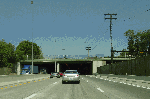
This 2002 photo shows the northbound New England Thruway (I-95) just past EXIT 17 (Chatsworth Avenue) in Larchmont). The thruway tunnels beneath the Larchmont Metro-North railroad station parking lot for several hundred yards. (Photo by Jim K. Georges.) |
||
|
REHABILITATING THE NEW ENGLAND THRUWAY: In 1980, the exits on the New England Thruway were renumbered in sequential order, continuing the exit numbering sequence of I-95 along the Trans-Manhattan, Cross Bronx and Bruckner expressways (which received their exit numbers in the early 1970's). The route was renumbered to comply with a Federal regulation, and to eliminate a conflict of exit numbers in New York City that has caused confusion among police, fire and other emergency services. Before the change, EXIT 1 on the New England Thruway was Pelham Parkway. Today, this is EXIT 8B and EXIT 8C. |
||
|
Beginning in 1982, the New England Thruway underwent extensive rehabilitation, complete with new roadways and bridges, throughout the entire length of the route. Some of the highlights of the project were the conversion of the New Rochelle toll plaza from two-way tolls to northbound-only tolls during the late 1980's, and the replacement of the Hutchinson River drawbridge with a new high-level bridge in 1996. After 17 years of reconstruction, the inconveniences of four narrow lanes, two in each direction, sharing one roadway ended in 1999 with the completion of work near the New York-Connecticut state line. |
||
|
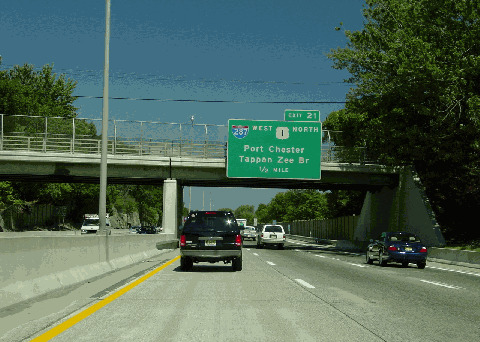
This 2002 photo shows the northbound New England Thruway (I-95) approaching EXIT 20 (US 1 SOUTH) and EXIT 21 (I-287 WEST and US 1 NORTH) in Rye. (Photo by Jim K. Georges.) |
||

|
This 1940 artist's conception shows the New England Thruway (Pelham-Port Chester Express Highway) looking northward through Westchester County. It was to relieve congestion along US 1 (Boston Post Road) and the Hutchinson River Parkway. The four-track New Haven (Amtrak / Metro-North) Railroad lies to the right of the six-lane, grade-separated highway. Note the left entrance and left exit on the northbound roadway. (Photo by Triborough Bridge and Tunnel Authority.) |
||

|
PROPOSED RELIEF FOR THE "HUTCH" AND US 1: In 1925, the Westchester County Parks Commission recommended the construction of a "Pelham-Port Chester Parkway" along the Boston Post Road (US 1) corridor between the Pelham-New Rochelle area and Port Chester. The Hutchinson River Parkway, which was being constructed parallel to the proposed Pelham-Port Chester Parkway, was also designed to relieve traffic on US 1. However, with the population growth of along the Long Island Sound corridor in Westchester County, it was feared that traffic on both US 1 and the Hutchinson River Parkway would increase. The inevitable development along this corridor necessitated construction of another parkway. |
||
|
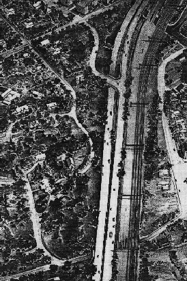
Despite opposition along the proposed route of the parkway, the Commission appropriated $3.5 million for right-of-way acquisition in 1929. The next year, the Commission voted to extend the parkway 1¼ miles south to Pelham Bay Park in the Bronx, where it was to connect to the east-west Pelham Parkway. At that time, a stone-arch, grade separation bridge, which carried Murray Avenue over the still non-existent parkway, was constructed in the area of the Larchmont Metro-North station. |
||
|
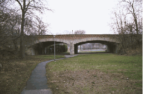
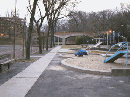
The Murphy Avenue overpass, shown here in these 1999 photos, was to cross the Pelham-Port Chester Parkway. This former right-of-way in Larchmont is now used as a park. (Photos by Douglas A. Willinger.) |
||


|
BRONX SERVICE AREA: A new service area, complete with truck parking facilities, should be constructed in the area of EXIT 13 (Connor Street) in the northeast Bronx. At the present time, there exists a 40-mile stretch along I-95 (from the Vince Lombardi service area in New Jersey to Fairfield County, Connecticut) without highway service areas. |
||


|
MORE REALISTIC SPEED LIMITS: The speed limits on the New England Thruway should be raised to 55 MPH in the Bronx and 60 MPH in Westchester County. |
||

|
SOURCES: Reports of the Westchester County Parks Commission (1926-1935), Westchester County Parks Commission (1935); "Freeways Are Now Urged," The New York Times (12/13/1936); "Vital Gaps in the New York Metropolitan Arterial System," Triborough Bridge Authority (1940); Highway Needs in New York State, New York State Department of Public Works (1949); "Let's Be Realistic About Thruways" by Hugh R. Pomeroy, Westchester County Planning Department (2/21/1950); "O'Dwyer Endorses Plans on Thruway" by Douglas Dales, The New York Times (3/07/1950); "Estimated Traffic, Revenue and Expenses on the New York State Thruway, New York State Thruway Authority (1951); "Plans, Planners and People: Case Reports from Westchester County on Some of the Human Aspects of Planning" by Hugh R. Pomeroy, Westchester County Planning Department (1955); "Dates Set To Open New Route from the Bronx to Rhode Island" by Merrill Folsom, The New York Times (7/18/1958); "Thruway Opening to New England" by Joseph C. Ingraham, The New York Times (10/18/1958); Arterial Progress 1959-1965, Triborough Bridge and Tunnel Authority (1965); "New England Thruway To Get New Exit Numbers" by Edward Hudson, The New York Times (2/17/1980); "Pioneering in Parks and Parkways: Westchester County, New York (1895-1945)" by Marilyn E. Weigold, Public Works Historical Society (February 1980); "Truck Stop and Rest Area Parking Study," Connecticut Department of Transportation (2000); New York Metropolitan Transportation Council; New York State Thruway Authority; Ralph Herman; Jeff Saltzman; Kevin Walsh; Douglas A. Willinger. |
||

|
NEW ENGLAND THRUWAY LINKS: |
||
|
NEW ENGLAND THRUWAY CURRENT TRAFFIC CONDITIONS: |
||
|
NEW ENGLAND THRUWAY VIDEO LINKS: |
||

|
THE EXITS OF METRO NEW YORK: |
||
|
|
||
|
Back to The Roads of Metro New York home page. |
||
|
Site contents © by Eastern Roads. This is not an official site run by a government agency. Recommendations provided on this site are strictly those of the author and contributors, not of any government or corporate entity. |
||