

|
|
||
|
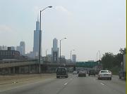
This 2019 photo shows the northbound Dr. Martin L. King, Jr. Expressway at EXIT 10 (I-278 / Staten Island Expressway). One-quarter mile south of this point, the Dr. Martin L. King, Jr. Expressway ends at Victory Boulevard. (Photo by Steve Anderson.) |
||
|
Length: |
||
|
2.6 miles (4.2 kilometers) |
||
|
CONNECTING THE SIE WITH THE BAYONNE BRIDGE: The Dr. Martin Luther King, Jr. Expressway, formerly known as the Willowbrook Expressway, connects Victory Boulevard and the Staten Island Expressway (I-278) with the Bayonne Bridge in the northern part of Staten Island. The four-lane expressway, which carries the NY 440 designation between I-278 and the Bayonne Bridge, was recommended in the 1955 Joint Study of Arterial Facilities as follows: |
||
|
A four-lane section of the Willowbrook Parkway would also be included in the Clove Lakes (Staten Island) Expressway construction. It would be necessary for this section to be designated an expressway in order to make it available to all types of vehicles. |
||
|
CURRENT AND FUTURE IMPROVEMENTS: According to the New York Metropolitan Transportation Council, the NYSDOT is undertaking a $10 million project to resurface the Dr. Martin L. King, Jr. Expressway. In the coming years, the NYSDOT plans to realign the southern terminus of the expressway at Victory Boulevard. The new exit ramps are planned to line up with the main entrance of the College of Staten Island, just east of the original right-of-way of the Willowbrook Parkway. |
||
|
This 2001 photo shows the northbound Dr. Martin L. King, Jr. Expressway (NY 440) at EXIT 13 (Richmond Terrace.) (Photo by Mike Tantillo.) |
||


|
CONTROVERSY THROUGH STATEN ISLAND GREENBELT: Planning for the Willowbrook Parkway began as early as 1930, when Robert Moses presented his master plan for the New York City parkway system before some five hundred civic leaders. The parkway, which was to connect the Bayonne Bridge with the South Shore of Staten Island, was to be part of a network of controlled-access highways serving Staten Island. Right-of-way acquisition, which was to provide the "ribbon parks" for the parkway, was completed in 1947. |
||
|
In 1955, the Joint Study also recommended the construction of a highway network for the rapidly growing borough. One of the recommended routes was an extension of the Willowbrook Parkway, whose use was to be restricted to passenger cars south of the Staten Island Expressway. |
||
|
This 2015 photo shows the Staten Island Rapid Transit (SIRT) railroad bridge over the right-of-way for the Willowbrook Parkway. The overpass was built in the 1950s as part of a borough-wide program to eliminate all SIRT grade crossings. The Willowbrook Parkway right-of-way from Victory Boulevard south to Hylan Boulevard now is under the jurisdiction of the New York City Department of Parks and Recreation. (Photo by Howard Fein.) |
||

|
HIGHER SPEED LIMITS FOR STATEN ISLAND: As with all controlled-access roadways in Staten Island, the speed limit on the Dr. Martin L. King Jr. Expressway should be increased to 55 MPH, from 50 MPH. |
||

|
SOURCES: Joint Study of Arterial Facilities, The Port of New York Authority and the Triborough Bridge and Tunnel Authority (1955); "Shore Front Drive," New York State Council of Parks (1962); "Hour Will Be Cut for Some Trips" by Joseph C. Ingraham, The New York Times (11/21/1964); "A Tour of Staten Island Improvements, and the Next Steps," Triborough Bridge and Tunnel Authority (1965); Arterial Progress 1959-1965, Triborough Bridge and Tunnel Authority (1965); "Richmond Parkway Location Report," New York City Department of Highways (1966); Transportation 1985: A Regional Plan, Tri-State Transportation Commission (1966); Public Works: A Dangerous Trade by Robert Moses, McGraw-Hill (1970); "Greenbelt Fans Want Routes off the Maps" by Jim O'Grady, The New York Times (11/22/1998); "State Weighs Several Fixes To Help Expressway" by Michael Wagner, The Staten Island Advance (8/01/2000); New York Metropolitan Transportation Council; Hank Eisenstein; Ralph Herman; David Zarkewicz. |
||

|
DR. MARTIN L. KING, JR. EXPRESSWAY LINKS: |
||
|
DR. MARTIN L. KING, JR. EXPRESSWAY CURRENT TRAFFIC CONDITIONS: |
||
|
DR. MARTIN L. KING, JR. EXPRESSWAY VIDEO LINKS: |
||

|
THE EXITS OF METRO NEW YORK: |
||

|
|
||

|
Back to The Roads of Metro New York home page. |
||
|
Site contents © by Eastern Roads. This is not an official site run by a government agency. Recommendations provided on this site are strictly those of the author and contributors, not of any government or corporate entity. |
||