 |
|
|
|
|
|
|
|
|
|
|
|
|
|
|
|
|
|
|
|
|
|
|
|
|
|
|
|
|
|
|
|
|
|
|
|
|
|
|
|
|
|
|
|
|
|
|
|
|
|
|
|
|
|
|
|
|
|
|
|
|
|
|
|
|
|
|
|
|
|
|
|
|
|
|
|
|
|
|
|
|
 |
|
|
|
|
 |
|
 |
|
|
|
|
|
|
|
|
|
|
|
|
|
|
|
|
 |
|
|
|
|
|
|
|
|
|
|
|
|
|
|
|
 |
|
|
|
|
|
|
|
|
|
|
|
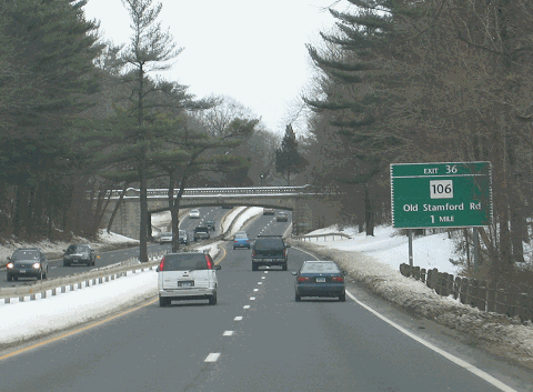
This 2006 photo shows the northbound Merritt Parkway (CT 15) approaching the Ponus Ridge Road overpass in Stamford. (Photo by Steve Anderson.)
|
|
|
|
|
|
|
|
|
 |
|
|
|
|
 |
|
|
|
|
|
|
|
|
|
37.3 miles (60.0 kilometers)
1935-1940
|
|
|
|
|
|
|
|
|
 |
|
 |
|
|
|
|
|
Passenger cars and Connecticut combination-plate vehicles only. Height restrictions apply.
|
|
|
|
|
|
|
|
|
|
|
|
|
|
 |
|
|
|
|
|
|
|
|
THE FIRST VIABLE POST ROAD BYPASS: Since colonial times, the Boston Post Road had served as the primary north-south link between New York City and New England. When the Post Road became US 1 under the Federal highway aid program of the 1920's, it received various improvements such as concrete paving and the addition of a third lane in rural areas. However, the explosive growth of local and inter-city traffic, as well as the Post Road's dual role as a main commercial street and inter-regional road, bred congestion and compromised safety.
In 1923, John MacDonald, the commissioner of the Connecticut State Highway Department, advanced three alternatives to alleviate traffic on Boston Post Road: These alternatives were as follows:
further widening of the Post Road, with new bypasses constructed around major population centers
construction of a new road exclusively for trucks, running parallel to the Post Road and the New York-New Haven Railroad
construction of a new road further inland
The first option was never constructed, while the second option was constructed in the 1950's as the Connecticut Turnpike (I-95). The third option, construction of a new highway inland, was similar to a proposal offered in 1923 by the Westchester County Park Commission. In this proposal, Robert Moses recommended the extension of the Hutchinson River Parkway, which was then under construction in Westchester County, into Fairfield County.
THE PROPOSED PARKWAY POLARIZES: The parkway extension, first envisioned by the Connecticut Automobile Parkway Corporation and later adopted by the New York-based Regional Plan Association (RPA), polarized the citizens of Fairfield County. On the one hand, many of the old Fairfield County landowners, particularly those with long family heritages and Republican Party connections, opposed the parkway. These natives bristled at the thought of New Yorkers invading their property on a parkway that would cut through their estates. In 1924, these residents formed the Fairfield County Planning Association (FCPA) to counter the State Highway Department proposal.
On the other hand, residents and businesses along the Post Road supported plans to siphon traffic from US 1 to an inland bypass. Although they did not have the organization of the landowners, they did receive the support of local newspapers.
To allay fears of the wealthy landowners, one FCPA board member from Stamford, Congressman Schuyler Merritt, recommended construction of a parkway that would not spoil the Fairfield County countryside:
A beautiful parkway is not wholly or primarily a means for quick transit, but it should be constructed so as to add beauty to the landscape, and therefore, help to attract desirable residents
and add a desirable element to the population.
But if the result is to be a highway designed and built like a railroad right-of-way, it will desecrate the beautiful country through which it passes and be a damage rather than a benefit to the county.
The FCPA campaigned for a parkway that would take advantage of the topography of the area, including its rivers, valleys and ridges, while minimizing the cuts and fills that would create a level road. Their objective was not to construct a road for new commuters, but one for the pleasure and recreation of those already living in Fairfield County.
|
|
|
|
|
|
|
|
|
|
|
|
|
|
|
|
|
|
|
 |
|
|
|
|
 |
|
 |
|
|
|
|
|
|
|
|
|
|
|
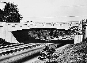
LEFT: Marvin Road spanning the Merritt Parkway in New Canaan. RIGHT: Plattsville Road spanning the Merritt Parkway in Trumbull. (Photos by Library of Congress, Prints and Photographs Division, Historic American Buildings Survey / Historic American Engineering Record / Connecticut Department of Transportation Collection, LC-HAER-CONN-1-NECA-6-2 and LC-HAER-CONN-1-TRUM-10-3.)
|
|
|
|
|
|
|
|
|
|
|
|
|
|
|
|
|
|
ORGANIZING THE MERRITT PARKWAY: In 1925, after two years of impasse between Fairfield County officials and representatives from the rest of Connecticut, the state legislature allocated $15,000 for a State Highway Department survey of highway needs in Fairfield County. Two years later, the legislative gave approval for construction of a trunk highway - not a parkway - between Greenwich and Stratford. However, the legislative approval did not include funds for construction of the highway.
In 1927, the Fairfield County Republican organization recommended that the new highway be called the "Merritt Boulevard" after the congressman who served the county. Merritt, however, suggested that the road be called the "Merritt Parkway" to convey a sense of the natural beauty of the proposed route.
The year 1931 is considered a turning point in the development of the Merritt Parkway. That year, a legislative package had been passed directing the state highway commissioner to map out the parkway. Another act that year appropriated $1 million in state funds for right-of-way acquisition and construction.
|
|
|
|
|
|
|
|
|
|
|
|
|
|
One act also called for Governor Wilbur Cross to establish a locally based Merritt Highway Commission to build and maintain the road, but this legislation was watered down under the influence of state highway commissioner MacDonald, who saw a parallel regional highway commission as a threat to his state highway commission. The state attorney general granted MacDonald full power and authority over the highway's planning and construction, and gave the locally based authority jurisdiction upon the road's completion.
|
|
|
|
|
|
|
|
|
|
|
|
|
|
|
|
|
|
FINANCING THE MERRITT PARKWAY: The original $1 million allocation from Hartford did not last long, going entirely for land acquisition in Greenwich. MacDonald estimated that the entire length of the parkway would cost $20 million to $30 million, and with the onset of the Great Depression, such funds were difficult to obtain. A number of efforts to sustain financing of the parkway died quietly in the state legislature.
On June 13, 1935, Governor Cross signed the bill that insured financing for the Merritt Parkway and extended financial powers to the Merritt Highway Commission. The 1935 legislation, which was advanced by state senator J. Kenneth Bradley, authorized the Commission to sell $15 million in bonds. This money would also insure construction jobs for 2,000 workers and a substantial share of Federal matching funds.
The 1935 legislation also called for two spur routes from the Merritt Parkway. One spur was to lead south to Sherwood Island State Park along the Long Island Sound in Westport, while the second spur was to connect the parkway to Boston Post Road in Stratford. Neither of these parkway spurs was constructed amid fears that hordes of New Yorkers would spoil nearby communities and Sound beaches. However, the state built a "Milford Parkway" spur years later to connect the Merritt and Wilbur Cross parkways to I-95 and US 1.
|
|
|
|
|
|
|
|
|
|
|
|
|
|
 |
|
 |
|
|
|
|
|
|
|
|
|
|
|
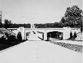
LEFT: South Avenue (CT 124) spanning the Merritt Parkway in New Canaan. RIGHT: Guinea (Rocky Craig) Road spanning the Merritt Parkway in Stamford. (Photos by Library of Congress, Prints and Photographs Division, Historic American Buildings Survey / Historic American Engineering Record / Connecticut Department of Transportation Collection, LC-HAER-CONN-1-NECA-10-4 and LC-HAER-CONN-1-STAMF-12-2.)
|
|
|
|
|
|
|
|
|
|
|
|
|
|
|
|
|
|
THE KEMP LAND SCANDAL: One of MacDonald's responsibilities as state highway commissioner was overseeing the Bureau of Rights-of-Way and Highway Boundaries, the agency that oversaw title searches and land acquisition. MacDonald selected G. Leroy Kemp, a Darien real estate broker and former Republican assemblyman, to the post of independent land procurer in 1932. Kemp, who was given responsibility for acquiring about 2,600 acres for the parkway right-of-way at $15 per day, had connections not only among local real estate agents, but also among Republican Party officials.
Kemp informed his contacts in the real estate business - specifically, Thomas Cooke of Greenwich and Samuel Silberman of Stamford - which parcels of land were needed. These two brokers would then approach their respective owners, offering their services to negotiate a selling price with the state. Since MacDonald kept the exact route of the proposed parkway a secret, the realtors were often the first people to tell the landowners about prospective purchases. This secrecy also kept other competing realtors out of the picture.
For this privileged information, Kemp arranged a fifty-fifty payback scheme in which the contact realtors agreed to split their fees with Kemp. This setup expedited the land acquisition process, since the landowners did not have to deal directly with negotiations and red tape at the state level. However, this came at a cost: the exorbitant prices that the state paid for the land inflated the overall cost of the parkway. In some cases, the state paid more than ten times the fair market value of the assessed properties.
By 1937, Warren M. Creamer, the state engineer in charge of design and construction of the Merritt Parkway, had grown suspicious of the excessive awards. His whistle-blowing drew the attention of state attorney general Edward Daly, who himself uncovered evidence of dubious land schemes. After a two-week trial, Kemp was the only person to be convicted and sentenced for his misdeeds. The two broker contacts, Cooke and Silberman, both got off with only a $500 fine. However, the repercussions of the Kemp land scandal forced the resignation of MacDonald three months later.
|
|
|
|
|
|
|
|
|
|
|
|
|
|
 |
|
 |
|
|
|
|
|
|
|
|
|
|
|
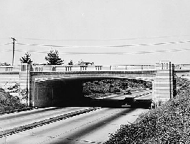
LEFT: Newfield Avenue spanning the Merritt Parkway in Stamford. RIGHT: Madison Avenue spanning the Merritt Parkway in Trumbull. (Photos by Library of Congress, Prints and Photographs Division, Historic American Buildings Survey / Historic American Engineering Record / Connecticut Department of Transportation Collection, LC-HAER-CONN-1-STAMF-8-2 and LC-HAER-CONN-1-TRUM-5-3.)
|
|
|
|
|
|
|
|
|
|
|
|
|
|
|
|
|
|
DESIGN AND LAYOUT: Under the supervision of state highway commissioner MacDonald, the original parkway guidelines established by the FCPA had been ignored. Instead of taking advantage of the topography, the original design would have flattened and straightened the parkway through the use of cuts and fills. While this design would have made the parkway faster and safer, it would have taken away from the parkway's idyllic character. After MacDonald resigned from the State Highway Department, the design of the Merritt Parkway became a more broadly shared responsibility.
Maintaining his responsibilities as chief project engineer, Warren Creamer employed other engineers and architects. Landscape engineer A. Earl Wood was employed in a full-time position in charge of landscaping the parkway to the wishes of the FCPA. Landscape architect Thayer Chase emphasized the use of native trees, plants and shrubs that would provide spring blossoms, summer shade and fall color with minimal maintenance. Rustic guardrails were designed to blend in with the local landscape. The median strip was planted with grass and "a sprinkling of trees here and there to break up the sameness and monotony of the greensward."
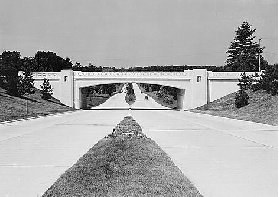
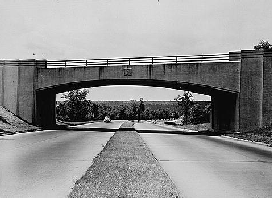
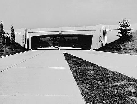
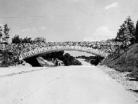
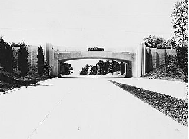
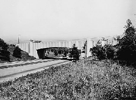
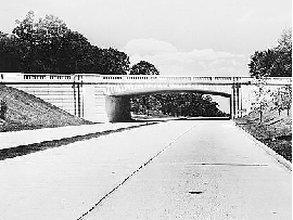
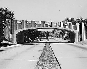
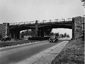
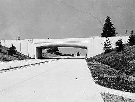
Two design engineers, John Smith and Leslie Sumner, designed the roadway layout and the structural engineering of the bridges. George Dunkelberger created the architectural design of each of the 69 unique bridges, all variations of the Art Deco style popular at the time, on the parkway. Bridges were built primarily of reinforced concrete, although several steel span and stone-faced bridges were constructed. Concrete was the material of choice primarily because of the lean economy of the Great Depression. Although the aesthetic qualities of concrete bridges were not highly thought of at the time, the parkway bridges were designed and crafted to overcome this perception. Rather than allowing flat concrete structures, Dunkelberger used sloping and curved wingwalls to lend visual interest, and to tie bridges into the surrounding landscape.
The effect was a 37.5-mile-long "ribbon park" that took advantage of the layout of the land by incorporating banked hills and curves. Although a 300-foot-wide right-of-way was reserved, the Merritt Parkway was constructed only along the northern 150-foot-wide section of right-of-way. The southern section was to have been used for a future four-lane expansion.
The design of the parkway roadbed, originally planned in the early 1930's as a single 40-foot-wide roadway with no median separation, was revised in 1935 to two 26-foot-wide roadways separated by a 22-foot, 4-inch median. Since the four-lane Merritt Parkway was to be an extension of the Hutchinson River Parkway, there were to be no at-grade intersections or traffic signals. Instead, access to and from local roads was to be through interchanges. To allow for separation of road and rail traffic, as well as for crossing rivers and streams, a total of 69 bridges were to be constructed.
While there was no formal documentation of the specific design standards to which the Merritt Parkway was constructed, it can be deduced from its horizontal and vertical curvature that it had a design speed of 45 MPH. This is supported by the fact that the original speed limit was also 45 MPH. Such a speed gave the traveling motorist the opportunity to view the natural landscape, native plantings and rolling farmlands.
Nevertheless, many characteristics conceived by the cost-cutting Commissioner MacDonald were incorporated into the final design. At overpasses and underpasses, MacDonald narrowed the landscaped median from the standard 22-foot, 4-inch width to a simple 16-inch concrete curb, minimizing the span (and therefore the cost) of the bridges. Moreover, many of the interchanges are "double-loaded," where the entrance and exit ramps share a single two-lane roadway divided only by yellow paint. The use of tight ramps and the lack of acceleration and deceleration lanes were also part of the design. While all of these measures were taken in the name of cost containment, they often compromised safety.
|
|
|
|
|
|
|
|
|
|
|
|
|
|
 |
|
 |
|
|
|
|
|
|
|
|
|
|
|
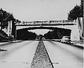
LEFT: North Street spanning the Merritt Parkway in Greenwich. RIGHT: Burr Street spanning the Merritt Parkway in Fairfield. (Photos by Library of Congress, Prints and Photographs Division, Historic American Buildings Survey / Historic American Engineering Record / Connecticut Department of Transportation Collection, LC-HAER-CONN-1-GREWI-8-2 and LC-HAER-CONN-1-FAIRF-19-4.)
|
|
|
|
|
|
|
|
|
|
|
|
|
|
|
|
|
|
|
|
|
|
|
|
|
|
|
|
THE MERRITT PARKWAY OPENS: The first 17.5-mile-long section of the Merritt Parkway between the New York-Connecticut border to Norwalk opened to the public on June 29, 1938. On September 2, 1940, the remaining 20 miles between Norwalk and Milford opened, completing a high-speed, limited-access parkway from the Bronx-Whitestone Bridge to New Haven County. The parkway was completed at a cost of $22.7 million, near the low end of Commissioner MacDonald's 1935 cost estimate.
The opening of the parkway was acclaimed by the local press, as evidenced by this editorial appearing in The Bridgeport Post:
One can build a concrete highway anywhere. But the Merritt Parkway is different. More than any "Futurama" at the World's Fair, more than any dream of the futuristic designers, it shows what the highway of the future should look like: a highway where the eye is filled with beauty and the mind with peace as the car purrs safely along.
The second section included the construction of the 1,824-foot-long Housatonic (Sikorsky) Bridge, a steel-grid deck span crossing the Housatonic River between Stratford and Milford. The use of the steel-grid deck cut one-third off the original $1.5 million price tag of the bridge and accelerated construction, but provided less traction for motorists than a conventional concrete deck.
TOLLS ON THE PARKWAY: In 1939, the State Highway Department implemented tolls on the Merritt Parkway. By legislation, the tolls were not intended to help pay for the Merritt Parkway, but instead to pay for its northward extension: the Wilbur Cross Parkway. The controversial move revived Connecticut's long tradition of tolls, which had been eliminated early in the twentieth century when tolls were removed from Boston Post Road.
The idea was not well received by Fairfield County residents, who were already paying for the road through taxes that were used to pay off its general obligation bonds. An additional "road user tax" was perceived as double taxation. Commuters were even more furious, since tolls had also been implemented on the Hutchinson River Parkway at the time.
The first temporary toll booths were constructed in June 1939. One year later, rustic log-cabin-like toll stations designed by George Dunkelberger were erected at Greenwich and Milford.
PARKWAY SERVICE AREAS: In 1940, three gas stations opened along the parkway at Greenwich, New Canaan and Fairfield. Although Dunkelberger designed the gas station buildings, their colonial design was borrowed from the Socony-Vacuum Oil Company (today's Mobil) stations common in New York and New England.
The contract with the State Highway Department stipulated that each parkway service station offer 24-hour gasoline and minor repair services, provide sales invoices for repairs, have a tow truck, and furnish clean restrooms. The successful bidder paid a nominal rent for the station, plus a royalty on each gallon of gasoline sold. This revenue went toward the State Highway Department's parkway maintenance fund.
|
|
|
|
|
|
|
|
|
|
|
|
|
|
 |
|
 |
|
|
|
|
|
|
|
|
LEFT: The New York, New Haven and Hartford Railroad bridge spanning the Merritt Parkway in New Canaan. RIGHT: Main Street (CT 25) spanning the Merritt Parkway in Trumbull. When CT 25 was rerouted to a new expressway in 1983, the Main Street overpass was redesignated as part of CT 111. (Photos by Library of Congress, Prints and Photographs Division, Historic American Buildings Survey / Historic American Engineering Record / Connecticut Department of Transportation Collection, LC-HAER-CONN-1-NECA-7-3 and LC-HAER-CONN-1-TRUM-6-2.)
|
|
|
|
|
|
|
|
|
|
|
|
|
|
|
|
|
|
LATER DEVELOPMENTS ON THE PARKWAY: The outbreak of World War II and the consequent gasoline rationing brought an 83 percent drop in traffic along the Merritt Parkway from pre-war levels. In January 1943, as part of its contribution to the war effort, the Merritt Parkway Commission dropped the restriction on trucks to allow the rapid movement of troops and materiel along the nearly empty parkway. The restriction was reinstated soon after V-J Day in 1945.
The Merritt Parkway received the CT 15 designation in 1948. (Before 1948, the parkway had the unposted legislative designation 1A.) The CT 15 designation continues north along the Wilbur Cross Parkway and Berlin Turnpike to East Hartford. Exit numbers along the Merritt Parkway also appeared that year, continuing the original exit numbering scheme of the Hutchinson River Parkway. The first exit for the Merritt Parkway at the New York-Connecticut border, EXIT 27 (NY 120A-King Street), originally the last exit number for the Hutchinson River Parkway. (In later years, the exit numbers changed on the Hutchinson River Parkway, giving King Street two noncontiguous exit numbers: EXIT 30 on the Hutchinson River Parkway, EXIT 27 on the Merritt Parkway.)
IMPROVEMENTS MADE, BUT WIDENING THWARTED: During the 1970s and 1980s, as the character of the Merritt Parkway shifted from scenic byway to a commuter alternative for the Connecticut Turnpike (I-95), the Connecticut Department of Transportation made a number of safety improvements, including the addition of acceleration and deceleration lanes and steel guardrails. The improvements were made to accommodate parkway speeds of up to 55 miles per hour.
Not all of the changes have been for the betterment of the parkway. Many of the original plantings had succumbed to pollution and disease, and some of the original bridges were altered beyond recognition. Despite the pleas of preservationists, newer freeway-style overpasses were erected at the intersection of the parkway with the US 7, CT 25, and CT 8 expressways. (However, these interchange designs were more subdued than those originally planned in the 1970s.) The loss of design integrity caused Thayer Chase, who had not been on the parkway in decades, to remark in 1991, "It ain't what it used to be."
Even during the early 1990s, planners considered adding four additional lanes to the Merritt Parkway. The $300 million project, which was to have taken place along a 32-mile-long stretch between Greenwich and Milford, was to relieve the congestion and safety "time bomb" that had developed along the parkway and nearby Connecticut Turnpike. Under public pressure, this plan to develop the southern 150-foot-wide right-of-way for four additional traffic lanes was dropped.
More recently, the Connecticut Transportation Strategy Board revived widening plans in a late 2002 draft report. The report called for widening the parkway to six lanes in order to relieve congestion on the Connecticut Turnpike (I-95). However, the Southwestern Regional Planning Agency did not support the findings of the report.
PRESERVATION EFFORTS: On April 17, 1991, the Merritt Parkway was listed on the National Register of Historic Places. John W. Shanahan, the director of the Connecticut Historical Commission, declared the following:
We need to give the parkway the legitimate recognition it has long deserved
By writing this nomination, we can make the case for the national significance of the parkway. We will be making decisions about the Merritt Parkway with the full knowledge of what we have, and why it is so special.
Two years later, Governor Lowell Weicker dedicated the Merritt Parkway as a "Scenic Road." He proclaimed the following at the dedication ceremony:
Highways preserve natural beauty that can still be constructed. There's no reason why they can't be utilitarian and beautiful.
With this principle in mind, Emil Frankel, the commissioner of the Connecticut Department of Transportation (ConnDOT), created the Merritt Parkway Working Group. The new organization was charged with advising ConnDOT of ways to preserve and enhance the Merritt Parkway while maintaining it as an important transportation artery. To implement the findings of the Working Group, a Merritt Parkway Conservancy has been proposed as a public-private partnership to highlight the parkway's importance as a historic and cultural resource.
|
|
|
|
|
|
|
|
|
|
|
|
|
|
 |
|
 |
|
|
|
|
|
|
|
|
LEFT: East Rocks Road spanning the Merritt Parkway in Norwalk. RIGHT: North Avenue spanning the Merritt Parkway in Westport. (Photos by Library of Congress, Prints and Photographs Division, Historic American Buildings Survey / Historic American Engineering Record / Connecticut Department of Transportation Collection, LC-HAER-CONN-1-NOWA-5-2 and LC-HAER-CONN-1-WESPO-11-3.)
|
|
|
|
|
|
|
|
|
|
|
|
|
|
|
|
|
|
CURRENT AND FUTURE IMPROVEMENTS: Maintaining the structural and historic integrity of the Merritt Parkway while interrupting traffic flow, currently estimated at more than 60,000 vehicles per day (AADT), is a challenge. ConnDOT has responded with the following improvements:
EXIT 31 (North Street) in Greenwich: Interchange reconfiguration, including extension of the parkway acceleration ramps and construction of new "T" intersections with North Street. (Due to right-of-way constraints, no changes will be made to the deceleration ramps.) Construction of the three-year, $12 million project was completed in 2004.
EXIT 34 (CT 104 / Long Ridge Road) in Stamford: The $5.1 million ramp modernization project was completed in 2001.
Just east of EXIT 37 (CT 124 / South Avenue) in New Canaan, ConnDOT rehabilitated the bridge over the Five Mile River. The concrete culverts and headwalls were replaced, and erosion protection was provided at the inlet and outlet of the structure. ConnDOT finished the project in late 2002.
During the late 1990s, ConnDOT rebuilt the Merritt Parkway overpass at EXIT 38 (CT 123 / New Canaan Avenue). The bridge over CT 123 was widened to accommodate new acceleration-deceleration lanes on the parkway. While the original bridge framing was salvaged and repainted, and the original abutments were rehabilitated, the widened lanes covered the original architectural features. Engineers replicated the features of the original design, but replaced the original riveted steel frames with more modern welded steel.
EXIT 39 (US 7 Expressway) and EXIT 40 (Old US 7 / Main Street) in Norwalk: At EXIT 39, ConnDOT plans to construct four new ramps (including two flyover ramps) to allow access to and from points east on the Merritt Parkway, and access to and from points north on the US 7 Expressway, thus completing the interchange. At EXIT 40, ConnDOT plans to convert the present cloverleaf interchange (the oldest in Connecticut) into a four-ramp "diamond" configuration. Work on the $98 million interchange project was scheduled to begin in 2005, but a lawsuit filed by the Merritt Parkway Conservancy and the National Trust for Historic Preservation held up construction amid concerns that the rebuilt interchange would create more congestion and destroy the character of the Merritt Parkway. In 2008, these groups reached an agreement with ConnDOT under which a less disruptive conventional cloverleaf interchange would be built instead. (ConnDOT planned a four-level "stack" interchange between the Merritt Parkway and the then-proposed US 7 Expressway in the 1970s, but backed away from this plan after hearing from preservationists.)
EXIT 44 (CT 58 / Black Rock Turnpike) in Fairfield: Changed the existing cloverleaf into a four-ramp interchange. EXIT 45 was "eliminated" as part of the project. This project was completed in 1999 at a cost of $4.6 million.
EXIT 48 (CT 111 / Main Street) in Trumbull: The existing diamond interchange was rebuilt as a single-point-diamond interchange (SPUI). As part of the project, the original bridge carrying CT 111 over the parkway will be replaced. The design of the new CT 111 overpass replicated the architectural design elements of the existing bridge. The interchange reconstruction project was finished in 2004.
EXIT 53 (CT 110 / River Road) in Stratford: Removed existing ramps (it used to have seven ramps) and converted to "diamond" interchange. This project was completed in 1999.
In 2006, ConnDOT completed a five-year project to replace the old four-lane, steel-grid deck Housatonic (Sikorsky) Bridge. The new $84 million Sikorsky Bridge, a five-span structure consisting of a combination of simple and continuous girders with composite concrete decks, has six 12-foot-wide travel lanes (three in each direction), 12-foot-wide left and right shoulders in each direction, and a multi-use path that may accommodate the proposed Merritt Parkway Trail. The new bridge was built in two stages. The first stage of construction was completed on November 24, 2003, and all traffic was diverted onto four narrow makeshift lanes on the new northbound span. This cleared the way for the demolition of the old Sikorsky Bridge, and the completion of the southbound span in mid-2006.
|
|
|
|
|
|
|
|
|
|
|
|
In 1993, the Regional Plan Association recommended that a pedestrian and cycling trail be constructed along the entire length of the parkway. The Merritt Parkway Trail, which is planned to connect with north-south trails along the US 7 and Housatonic Valley corridors, is intended to become part of the East Coast Greenway from Maine to Florida.
|
|
|
|
|
|
|
 |
|
|
|
|
|
|
|
|
|
|
THE MERRITT PARKWAY AS TESTING GROUND: A drive along the Merritt Parkway through Fairfield County reveals examples of non-standard signs. New exit and destination signs installed recently along the length of the parkway have non-FHWA font lettering on dark green backgrounds, bordered by jagged white edges. The new exit and destination signs are reminiscent of older, non-standard signs on the Merritt Parkway. The older, dark-green signs were made up of several wooden boards, each of which had an inverted triangle cut from each end. White lettering, all in capitals, was affixed to the dark green wooden signboards. Most of these wooden signs were replaced in the 1970's, although a few made it to the 1980s.
In addition, there are also a number of CT 15 reassurance shields along the parkway that have the state outline instead of the usual square.
|
|
|
|
|
|
|
|
|
|
|
|
|
|
 |
|
 |
|
|
|
|
|
|
|
|
|
|
|
LEFT: Lake Avenue spanning the Merritt Parkway in Greenwich. RIGHT: Comstock Hill Road spanning the Merritt Parkway in Norwalk. (Photos by Library of Congress, Prints and Photographs Division, Historical American Buildings Survey / Historical American Engineering Record / Connecticut Department of Transportation Collection, LC-HAER-CONN-1-GREWI-7-4 and LC-HAER-CONN-1-NOWA-4-6.)
|
|
|
|
|
|
|
|
|
|
|
|
|
|
|
|
|
|
|
 |
|
|
|
 |
|
|
|
|
|
SOURCES: "$15 Million for Highway," The New York Times (11/02/1933); "Merritt Road Ready," The New York Times (9/01/1940); "Meskill Scraps Merritt Parkway Plans" by Michael Knight, The New York Times (12/08/1973); "Report Asserts Fairfield Needs No New Expressways for Years" by Michael Knight, The New York Times (2/13/1975); "The Merritt Turns a Graceful 50" by Pete Mobilia, The New York Times (7/01/1984); "Plan Would Double Parkway" by Dennis C. Milewski, United Press International (12/17/1984); Connecticut's Historic Highway Bridges by Bruce Clouette and Matthew Roth, Connecticut Department of Transportation (1991); "US 7 and Merritt Parkway (CT 15) Interchange Reconstruction: Draft Environmental Impact and Section 4(f) Statement," Federal Highway Administration and Connecticut Department of Transportation (1992); The Merritt Parkway by Bruce Radde, Yale University Press (1993); "A Group Pushes To Preserve the Merritt" by Diane Sierpina, The New York Times (10/24/1999); "Innovative Solutions for the Historic Merritt Parkway" by Vincent C. McDermott, Nancy M. Wilks, Nomy Zingher and Peter S. Szabo, National Trust for Historic Preservation (4/07/2000); "Merritt Parkway Over Route 123," Modern Steel Construction (July 2000); "Work Begins on Replacement of Sikorsky Memorial Bridge," The Associated Press (5/07/2001); "Draft Report of the Working Group on the Movement of Goods," Connecticut Transportation Strategy Board (2002); "End of the Road for Route 7 Connector Terminus" by Matt Breslow, The Norwalk Advocate (6/12/2003); "Merritt Parkway Cruises to Its 65th Anniversary" by Marian Gail Brown, The Connecticut Post (6/29/2003); "Crane Collapse Kills Construction Worker at Sirkorsky Bridge in Connecticut" by Stacey Stowe, The New York Times (2/18/2004); "Lawsuit Filed To Block $98 Million Road Project," The Greenwich Time (6/01/2005); "Department of Transportation Plans To Open the Second Side of the Sikorsky Bridge by 2006" by Rob Varnon, The Connecticut Post (6/12/2005); "State Will Unveil Plans for Route 7 Interchange" by Jonathan Lucas, The Norwalk Advocate (2/15/2008); "Route 7 Dispute Settled" by Chris Gosier, The Norwalk Advocate (3/17/2008); Berger, Lehman Associates; Connecticut Department of Transportation; Regional Plan Association; Leo Auray; Erich Bachman; Phil Case; Yuri Dieujuste; Jay Hogan; Ayan R. Kayal; Neil Kelly; Mike Natale; Scott Oglesby; Jon Persky; Len Pundt; Alexander Svirsky.
CT 15 shield by Barry L. Camp.
Merritt Parkway shield by James Lin.
Bike route sign by Richard C. Moeur.
|
|
|
|
|
|
|
|
|
|
|
|
|
|
|
|
 |
|
 |
|
|
|
|
|
|
|
|
|
|
|
|
 |
|
|
|
|
|
|
|
|
 |
|
|
|
|
|
|
|
|
|
 |
|
|
|
|
|
THE EXITS OF METRO NEW YORK
Merritt Parkway exit list by Steve Anderson.
|
|
|
|
|
|
|
|
|
|
|
 |
|
|
|
|
|
|
|
|
|
|
|
|
Site contents © by Eastern Roads. This is not an official site run by a government agency. Recommendations provided on this site are strictly those of the author and contributors, not of any government or corporate entity.
|
|
|
|
|
|
|
|
|
|