 |
|
|
|
|
|
|
|
|
|
|
|
|
|
|
|
|
|
|
|
|
|
|
|
|
|
|
|
|
|
|
|
|
|
|
|
|
|
|
|
|
|
|
|
|
|
|
|
|
|
|
|
|
|
|
|
|
|
|
|
|
|
|
|
|
|
|
|
|
|
|
|
|
|
|
|
|
|
|
|
|
|
|
|
|
|
|
|
|
|
|
|
|
|
|
 |
|
|
|
|
 |
|
 |
|
|
|
|
|
|
|
|
|
|
|
|
|
|
|
|
 |
|
|
|
|
|
|
|
|
|
|
|
|
|
|
|
 |
|
|
|
|
|
|
|
|
|
|
|
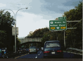
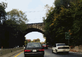
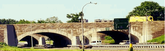
This 1998 photo shows the northbound Hutchinson River Parkway at EXIT 9 (Wolffs Lane) in Pelham, just north of the Bronx-Westchester border. (Photo by Steve Anderson.)
|
|
|
|
|
|
|
|
|
 |
|
|
|
|
 |
|
|
|
|
|
|
|
|
Length:
Constructed:
NYSDOT Reference Route:
|
|
|
|
|
|
|
|
|
18.8 miles (30.2 kilometers)
1924-1941
NY 908A (Bronx); NY 907W (Westchester)
|
|
|
|
|
|
|
|
|
 |
|
 |
|
|
|
|
|
Passenger cars only. Height restrictions apply.
|
|
|
|
|
|
|
|
|
|
|
|
|
|
|
|
|
|
|
 |
|
|
|
|
|
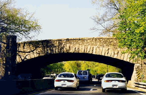
One of the pioneer parkways in the Westchester Parks system, the Hutchinson River Parkway was named after Anne Hutchinson, a Westchester resident and one of the 17th century pioneers of religious freedom in the American colonies. The Hutchinson River Parkway shared rustic characteristics of such as stone-arch bridges, wooden lightposts and gently sloped curves that characterized the New York parkways of the 1920s and 1930s.
|
|
|
|
|
|
|
|
|
|
|
|
|
|
|
|
|
|
|
|
|
THE ORIGINAL PARKWAY: In 1924, the Westchester County Parks Commission recommended construction of a new north-south parkway in the eastern part of the county. At that time, Boston Post Road (which became US 1 in 1926), the primary north-south route along Long Island Sound between New York City and New England, had become clogged with automobile and truck traffic seven days a week. Moreover, the rapid growth of Mount Vernon, Pelham, New Rochelle, Eastchester and Port Chester threatened the water supply of these communities. Preservation of right-of-way for a parkway along the Hutchinson River would offer relief along US 1 by providing a faster, more scenic route for automobiles. It would also furnish parks for local residents and protect water supplies.
From the Westchester County Parks Commission Report written in 1927:
The lands acquired embrace a well-developed park area, forming a valuable local expansion of the Hutchinson River Parkway while providing a scenic location for the parkway.
Construction of the Hutchinson River Parkway began in 1924. In December 1927, workers completed a short two-mile section of the parkway in Pelham. The section included a new multiple-arch stone bridge to carry the New York, New Haven and Hartford Railroad (Metro-North New Haven line) over the Hutchinson River Parkway and the adjacent river. Prior to construction of the parkway, the railroad had been on a solid embankment. The bridge was constructed underneath the embankment.
By October 1928, an 11-mile section of parkway was completed between US 1 in Pelham and Westchester Avenue in White Plains. Upon completion, the new parkway served mostly local traffic within Westchester County. The parkway complied with the design standards of the era, with four 9-foot-wide travel lanes and a 40 MPH design speed. It did not have median separation, shoulders or acceleration-deceleration lanes. The entire 11 miles of parkway, which included bridle paths along the right-of-way, as well as a riding academy where the public could rent horses, cost $12 million to build.
|
|
|
|
|
|
|
|
|
 |
|
|
|
|
|
 |
|
|
|
|
|
|
|
|
|
|
|
|
|
|
|
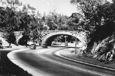
The Hutchinson River Parkway in New Rochelle, not long after it opened in 1928. (Photo by Library of Congress, Prints and Photographs Division, LC-119876.)
|
|
|
|
|
|
|
|
|
|
|
|
|
|
 |
|
|
|
|
|
EXTENDING NORTH TO CONNECTICUT: As early as the 1920's, New York master builder Robert Moses, as well as a number of officials from Connecticut, recommended an extension of the limited-access Hutchinson River Parkway into Fairfield County. These plans came to fruition in 1937, when the Hutchinson River Parkway was extended north from White Plains to King Street (NY 120A) in Rye Brook, on the New York-Connecticut border.
|
|
|
|
|
|
|
|
|
|
|
|
|
|
Connections were constructed for a future extension of the Hutchinson River Parkway into Connecticut, where it was to be known as the Merritt Parkway (CT 15). This parkway opened north to the Housatonic River Bridge in 1940, and was extended further north as the Wilbur Cross Parkway in 1949.
EXTENDING SOUTH TO THE WHITESTONE BRIDGE: In 1936, not long after what had been called the greatest traffic tie-up in the history of the New York metropolitan area, Moses decided to build more parkways in the Bronx and Westchester: "It's time we gave Westchester a break." One of these plans was to connect the completed section of the Hutchinson River Parkway to the proposed Bronx-Whitestone Bridge.
The first stage of this project, a 1.5-mile extension extending south from US 1 in Pelham Manor to Orchard Beach Road in Pelham Bay Park, was completed in December 1937. At the time of its completion, Robert Moses proposed the following in New Parkways in New York City:
This report recommends the extension in a southerly direction of the Hutchinson River Parkway directly to the Bronx-Whitestone Bridge approach at Eastern (Bruckner) Boulevard. A part of this extension has already been constructed in Pelham Bay Park. The plan is to continue south to the bridgehead.
|
|
|
|
|
|
|
|
|
|
|
|
|
|
Most of the modern parkway construction in the metropolitan area has been outside of the limits of New York City, and has been done with county, state and bridge authority funds. Landscaped parkways, with restricted access and frontage, have been proven not only to be the most efficient way of providing for a smooth flow of traffic, but also to be great neighborhood assets from the point of view of desirable residential growth. Unfortunately, most of the new parkways have stopped at the city border. It is now proposed to extend them into the heart of the City, and to offer an effective substitute for the present bottleneck along city streets. When completed, the parkways will comprise one unified system.
|
|
|
|
|
|
|
|
|
|
|
|
|
|
|
|
|
|
The southern extension of the Hutchinson River Parkway into the Bronx was completed in 1941, two years after the bridge was opened to traffic, and four years after the parkway first entered the Bronx. When it opened, the parkway had four lanes, but unlike the Westchester section, it had median separation. The Bronx section was widened to six lanes (three in each direction) in the late 1940's.
According to Robert A. Caro in The Power Broker, Moses would be rewarded for constructing the parkway:
In 1950, Hetty Green, an eccentric millionairess who had long felt grateful to Moses for building the Hutchinson River Parkway, which have her "such pleasure" driving to and from her homes in Manhattan and Greenwich, Connecticut, died, and on the reading of her will, it was discovered that her gratitude had taken practical form: a $10,000 bequest to Robert Moses.
|
|
|
|
|
|
|
|
|
|
|
|
When the southern extension to the Bronx-Whitestone Bridge was completed, the Hutchinson River Parkway between Eastern Boulevard (later Bruckner Expressway) and US 1 in Pelham Manor was designated NY 1X. The parkway was re-designated NY 1A in 1946; this designation was removed in 1972.
|
|
|
|
|
|
|
 |
|
|
|
|
|
|
|
|
|
|
GAS STATIONS ON THE PARKWAY: Two service areas were constructed along the parkway to provide gasoline for motorists. The Westchester service area, which is located just south of EXIT 25 (NY 127 / North Street) in White Plains, consists of a single median gas station built of stone construction in the 1930s. The Bronx service area, which is located just south of EXIT 2 (Westchester Avenue), consists of a pair of gas stations (along the northbound and southbound lanes) built of stone construction in the early 1940s. Both service areas remain in operation.
|
|
|
|
|
|
|
|
|
|
|
|
|
|
 |
|
 |
|
|
|
|
|
|
|
|
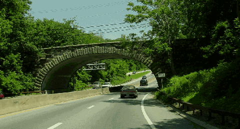
LEFT: This 1998 photo shows the northbound Hutchinson River Parkway approaching EXIT 7 (US 1 / Boston Post Road), near the Bronx-Westchester border. The overpass for the New England Thruway (I-95) lies ahead. RIGHT: This 1998 photo shows the northbound Hutchinson River Parkway at the historic Metro-North New Haven line overpass in Pelham. (Photos by Jeff Saltzman.)
|
|
|
|
|
|
|
|
|
|
|
|
|
|
|
|
|
|
|
|
|
|
INITIAL IMPROVEMENTS: Increased traffic volumes on the extended Hutchinson River Parkway necessitated immediate improvements to the original parkway section from Boston Post Road north to Westchester Avenue. This improvement, which was completed in 1938, widened the roadway to two directional 23-foot-wide pavements (allowing for two 11½-foot-wide lanes in each direction), separated by a four-foot-wide curbed median (where there was no median separation before).
|
|
|
|
|
|
|
|
|
|
|
|
|
|
Nevertheless, the design of the parkway was incompatible with the greater traffic demands and higher speeds of the postwar era. At 30 locations, the horizontal curvature exceeded the maximum desirable 3.5-degree limit, and at 27 locations, the gradient exceeded the maximum desirable four-percent limit. The absence of shoulders and acceleration-deceleration lanes not only created traffic bottlenecks, but was also a cause of accidents.
INITIAL EXPANSION ATTEMPTS (1953-1972): By the early 1950s, the Hutchinson River Parkway carried approximately 30,000 vehicles per day (AADT), twice the number of vehicles that used the parkway in 1945. Traffic studies found that the parkway "reasonably safe for operating speeds of only about 25 MPH," and that traffic was expected to double again by 1958. To address the growing traffic demands and high accident rates on the parkway, the Westchester County Planning Department and the Westchester County Parks Commission devised the following four plans:
PLAN W: This plan raised the possibility of constructing a new parkway on a new right-of-way between the existing Hutchinson River Parkway and the New England Thruway (I-95). Due to the high cost of right-of-way acquisition and attendant possibility of community opposition, this solution was discarded immediately as unwarranted until full use had been made of the existing parkway right-of-way. No cost estimate was provided for this plan.
PLAN X: Under the "parkway reconstruction" alternative, new lanes and bridges would be added to the existing parkway to provide eight 12-foot-wide lanes and ten-foot-wide shoulders from the Bronx-Whitestone Bridge north to Westchester Avenue, and six 12-foot-wide lanes and ten-foot-wide shoulders from Westchester Avenue to the Merritt Parkway. (Provisions would be made to increase the six-lane section to eight lanes when required.) To prevent weaving, a divider strip would be placed on eight-lane sections (in effect creating collector-distributor roads). Alignment and profile changes would be made along the existing right-of-way where horizontal and vertical sight distances were limited. Most existing stone-arch bridges would be preserved; parallel bridges with identical design would be constructed. Pavements on both the new and existing roadways would be constructed to modern standards. To permit a 60 MPH design speed on the main roadway, shoulders and acceleration-deceleration lanes would be added, and entrance-exit ramps would be reconstructed to permit safe operation at 40 MPH. Finally, landscaping, lighting and signing would be revised. This plan was estimated to cost $36 million.
PLAN Y: Under the "fairly extensive adjustment" alternative, a non-traversable barrier, resurfacing and ten-foot-wide shoulders would be added to the parkway. Some profile and alignment changes would be made, and some interchange ramps would be reconstructed, but no increase in the number of traffic lanes would be provided. These design changes would only permit a design speed of 50 MPH. This plan was estimated to cost $11 million.
PLAN Z: The "minimum adjustment" alternative includes resurfacing, construction of shoulders and center barricades, but minimizes adjustment to parkway alignment, profile and interchanges. These design changes would only permit a design speed of 30 MPH. This plan was estimated to cost $8 million.
The 1953 "Report on the Reconstruction and Improvement of the Hutchinson River Parkway" recommended the implementation of the "Plan X" reconstruction alternative by stating the following:
The design of the Hutchinson River Parkway is so inadequate for modern day traffic throughout most of its length that the reconstruction of spot locations of greatest deficiency, such as where sharp curves or limited sight distances are encountered, would prove ineffective in reducing accidents and congestion. The widths of the existing grade separations will not permit widening of the roadway to provide more lanes, adequate shoulders and median widths. The practical capacity of the present four lanes is already exceeded. For these reasons, the minor improvements seem economically impracticable.
The reconstruction was originally scheduled for completion by 1956, but by 1961, when a new state agency - the East Hudson Parkway Authority - took over the parkway, not much had been done through Westchester County except for the addition of a median strip.
In its 1962 report Regional Highways: Status Report, the Tri-State Transportation Commission recommended a modified form "Plan X." Unlike the earlier plan, the Commission advocated upgrading the road to expressway standards from the Cross Westchester Expressway (I-287) south to the Bronx-Whitestone Bridge. The "Hutchinson River Expressway" was to permit use by trucks and buses.
Ultimately, only a short section from the "Bruckner interchange" south to the Bronx-Whitestone Bridge was upgraded to expressway standards as part of I-678. This short upgrade, which widened the road to eight lanes and reconstructed bridges, was completed in 1972. Plans for an extended upgrade were canceled after the Federal Highway Administration (FHWA) denied New York's application to extend I-678 north to I-95 near the Bronx-Westchester border. (This section was referred in 1970 documents as the "Co-Op City Bypass.")
|
|
|
|
|
|
|
|
|
|
|
|
|
|
|
 |
|
|
|
|
|
|
|
|
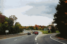
This 2002 photo shows the northbound Hutchinson River Parkway just north of EXIT 17 (North Avenue) in New Rochelle. (Photo by Jim K. Georges.)
|
|
|
|
|
|
|
|
|
|
|
|
|
|
|
|
|
|
|
|
|
|
|
|
 |
|
|
|
|
|
LATER EXPANSION ATTEMPTS (1982-1994): In 1982, two years after the New York State Department of Transportation (NYSDOT) took over jurisdiction of the Hutchinson River Parkway, state and local officials mulled over plans to rehabilitate the parkway, bringing it closer to current safety and design standards.
|
|
|
|
|
|
|
|
|
|
|
|
|
|
The Westchester County Parks Commission, which still maintained the linear park along the road, recommended a $73 million proposal that would widen the parkway to six lanes for 7.4 miles between EXIT 15 (Cross County Parkway) in Bronxville and EXIT 26 (I-287 / I-684 interchange) in Harrison. The NYSDOT offered its own scaled-down $55 million plan, which kept the parkway at four lanes but had wider sections at key interchanges.
During contentious meetings held during the summer of 1982, community leaders along the route of the parkway opposed the six-lane expansion, arguing that the widening would bring increased traffic, noise and pollution. Ultimately, the expansion was limited to the area around the I-287 / I-684 interchange, and the area around the Cross County Parkway.
Douglas A. Willinger of the Takoma Park Highway Design Studio, a misc.transport.road contributor and former Westchester County resident, recalls the debate as follows:
There are only two segments of the Hutchinson River Parkway in Westchester that are more than four lanes. One is at its meeting with the northern spur of the Cross County Parkway in Bronxville. The other is at the intersection of the Hutch with the Cross Westchester Expressway (I-287) and I-684 in White Plains.
There is a third segment, at the interchange with Mamaroneck Avenue, which has six paved lanes. However, only four lanes are in use. This was from the 1984-1985 construction, following the 1982 decision to widen the Hutch to six lanes (three each way) from Mamaroneck Ave to I-287. The NYSDOT proposed this in 1982 to widen the Hutch south of Mamaroneck Avenue. I attended the 1982 public hearing on the project, which was held at New Rochelle High School. Most of the people in attendance were from the New Rochelle-Scarsdale area that would have been affected by the expansion, and they opposed capacity expansion from four to six lanes.
In 1985 a Dr. Liebret moved to Harrison and started a movement to stop the six-lane Hutch north of Mamaroneck Avenue and won (around 1987-1988). However, because his group focused too exclusively upon the number of lanes, NYSDOT successfully put through what was the six-lane road (built 1990-1991), minus the extra pavement, but with the necessary second stone-faced arch bridge.
In one sense the Hutch is six lanes in the vicinity of I-287, specifically at its approach to I-287, opening up with additional lanes to run beneath the I-287 overpass to four lanes each way for the left split for I-684, and the right split for the remaining, unreconstructed Hutch. The latter leads directly to Connecticut's Merritt Parkway.
The Hutchinson River Parkway could be upgraded with extra capacity in a tasteful manner by building duplicate stone-faced concrete arch bridges. This would allow the existing bridges to span one direction of traffic, while the new bridges would span the other direction, as has been done with the 1990-1991 reconstruction of the Hutch in Harrison, just south of the interchange with I-287. However, allowing heavy trucks would be another matter. The existing overpasses are too low (9 feet to 13 feet), to say nothing of the local opposition such a plan would almost certainly bring.
In 1984, the NYSDOT began a decade-long reconstruction of the Hutchinson River Parkway. Horizontal and vertical sight distances were improved, curves were straightened, acceleration and deceleration lanes were lengthened, and other safety improvements were made. To accommodate these improvements, two exits - EXIT 11 (Sparks Avenue) in Pelham and EXIT 24 (West Street) in Harrison - were eliminated. The reconstruction project was completed on October 31, 1994, when the 25-cent Pelham Manor toll plaza between EXIT 7 (US 1 / Boston Post Road) and EXIT 8 (Sanford Boulevard) was removed.
|
|
|
|
|
|
|
|
|
|
|
|
|
|
 |
|
 |
|
|
|
|
|
|
|
|
LEFT: This 1998 photo shows the northbound on the Hutchinson River Parkway at EXIT 14 (Pelhamdale Avenue-Eastchester Road) on the Pelham-New Rochelle border. RIGHT: This 1998 photo shows the northbound Hutchinson River Parkway approaching EXIT 26 (I-287 / Cross Westchester Expressway) in Harrison. (Photos by Jeff Saltzman.)
|
|
|
|
|
|
|
|
|
|
|
|
|
|
 |
|
|
|
|
|
CURRENT AND FUTURE IMPROVEMENTS: In mid-1999, construction crews moved beyond the I-287 / I-684 interchange in Harrison to reconstruct the Hutchinson River Parkway north to the New York-Connecticut border. The project added a parallel roadway to the west of the existing four-lane parkway, and included the reconstruction of parkway bridges. In some places, the existing bridges were kept, while in other places, new stone-arch bridges were erected.
Soon after construction began, Bob Bailin posted the following about the Hutchinson River Parkway project in misc.transport.road:
|
|
|
|
|
|
|
|
|
|
|
|
|
|
They did more than remove a few trees, they cut down hundreds, effectively removing the canopy effect that that section of the parkway used to have. It looks like they're doing the same thing to this section of the pkwy that they did to the section between I-287 and the Cross County over the past ten years. The widening project will kill the aesthetics of the road, but was long overdue because it will eliminate the parkway's dangerous hairpin curves. Nevertheless, I just hope this little project doesn't give ConnDOT any ideas about the Merritt.
Douglas A. Willinger had the following observation about the improvement project:
Having just recently visited my family's home in Westchester County, I took a look at the ongoing reconstruction of the Hutchinson River Parkway from I-287 north to the Connecticut state line. One local road that crosses over the Hutch with a single arch, is being supplemented with a new stoned faced concrete bridge. However, this new bridge features not one but two separate arches, in a style different than the existing single arch that has carried both directions of the Hutch. Additionally, these two new separate "arches" are narrower than the existing arch, each barely wide enough for two lanes apiece.
Why would the NYSDOT be constructing such a bridge in a non-matching architectural style? Do they intend to run each direction of the Hutch via one of the new narrower "arches", or the southbound lanes under one arch, while leaving the northbound lanes under the existing arch? Or do they even intend to maintain the existing larger arch bridge (e.g., tearing it down)?
Jim Mearkle, a civil engineer with the NYSDOT, responded as follows:
(The Ridge Street over the HRP is) not a parallel span; it's a replacement. The new cross section of the Hutch is considerably wider than the old section, and wouldn't fit beneath the old structure. It was decided to demolish the old span, and replace it with a two-span structure with a pier in the median.
Before the $38 million project was completed in March 2002, northbound traffic utilized the existing roadway, while southbound traffic was diverted to the new roadway. The two new carriageways are both built to contemporary design standards, featuring two 12-foot-wide lanes and ten-foot-wide shoulders in each direction, standard acceleration and deceleration lanes, and improved sight lines.
Moving toward the southern terminus of the parkway, the NYSDOT recently completed a $155 million, three-year-long reconstruction of the "Bruckner interchange" with the Cross Bronx Expressway (I-95 / I-295) and the Bruckner Expressway (I-278 / I-95). The work, which involved reconstructing 14 ramps and bridge structures, installing new drainage and electrical systems, and placing new guardrails and signs, was completed in June 2002, nearly one year ahead of schedule. Included in the project was the repaving of the Hutchinson River "expressway" approach (I-678) to the Bronx-Whitestone Bridge.
Through the end of the decade, the NYSDOT and the New York Metropolitan Transportation Council have scheduled the following projects on the Hutchinson River Parkway:
The NYSDOT impletmetned ITS improvements along the length of the parkway in Westchester County. The $7 million project was completed in 2004.
Reconstruction of the Hutchinson River Parkway through the Bronx, completed in 2005. This project, which includes safety and efficiency improvements such as improved guardrails, lighting and signing, cost $70 million. It also includes the reconstruction of the East Tremont Avenue bridge over the parkway. (In the Bronx, the New York City Department of Transportation (NYCDOT) maintains the Hutchinson River Parkway, and the New York City Parks Department maintains surrounding rights-of-way. Major reconstruction work is undertaken by the NYSDOT, which also installs signs and reference markers.)
According to the NYSDOT, the Hutchinson River Parkway handles approximately 110,000 vehicles per day (AADT) through the borough of the Bronx, approximately 95,000 vehicles per day from the Bronx-Westchester border north to the I-287 / I-684 interchange in Harrison, and approximately 50,000 vehicles per day from the I-287 / I-684 interchange north to the Merritt Parkway (CT 15).
|
|
|
|
|
|
|
|
|
|
|
|
|
|
 |
|
|
|
|
|
|
|
|
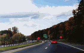
This 1997 photo shows the stone-arch overpass carrying the New England Thruway (I-95) over the Hutchinson River Parkway in Co-Op City. (Photo by Jeff Saltzman.)
|
|
|
|
|
|
|
|
|
|
|
|
|
|
|
|
|
|
|
|
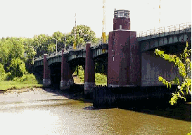
THE HUTCHINSON RIVER PARKWAY BRIDGE: The Hutchinson River Parkway Bridge over the Hutchinson River in the Bronx is a seven span, six-lane structure with a sidewalk on the west side. It consists of a 130½ -foot-long main bascule drawbridge span, flanked on both sides by three side spans. The bascule bridge is a four-leaf deck with steel median barriers between the northbound and southbound lanes. The six fixed side spans are made of steel structure with 8½-inch concrete slab on top and concrete median between the northbound and southbound roadways. In the closed position, the bridge allows a vertical clearance of 35 feet.
|
|
|
|
|
|
|
|
|
|
|
|
|
|
Opened to traffic in 1941 when the Hutchinson River Parkway was extended into the Bronx, the Hutchinson River Parkway drawbridge was reconstructed in 1985. The bridge is operated and maintained by the NYCDOT.
THE HUTCHINSON RIVER-MERRITT GREENWAY: As each section of the Hutchinson River Parkway was completed, bikeways were included in the design. The bikeway still exists from the Bronx-Whitestone Bridge to the Westchester-Fairfield line, but has deteriorated significantly over the years. It has also been interrupted in many locations by the construction of new entrance and exit ramps.
|
|
|
|
|
|
|
|
|
|
|
|
In 1993, the Regional Planning Association (RPA) completed a study supporting the feasibility of a bicycle and pedestrian path along the Hutchinson River and Merritt Parkways. The trail would serve commuters as well as recreational users. The combined Hutchinson River-Merritt Greenway would also provide the missing link in the East Coast Greenway, a planned bicycle and pedestrian path from Maine to Florida. While this plan meets ISTEA requirements to develop alternative means of transportation, the states of New York and Connecticut are still seeking funding.
|
|
|
|
|
|
|
 |
|
|
|
|
|
|
|
|
|
|
More recently, activist Dave Lutz of the Neighborhood Open Space Institute was influential in protecting the status of parkway "buffer" by his discovery of an abandoned macadam trail that ran through the right-of-way. The discovery came in wake of a 2001 decision by the New York State Supreme Court that "parkland acquired for the purpose of creating a parkway is not protected from alienation as dedicated parkland."
|
|
|
|
|
|
|
|
|
|
|
|
|
|
 |
|
 |
|
|
|
|
|
|
|
|
The Hutchinson River Parkway drawbridge, as shown in these 1998 photos, crosses over the Hutchinson River in the Bronx. Opened in 1941, the drawbridge was reconstructed in 1985.(Photos by Jeff Saltzman.)
|
|
|
|
|
|
|
|
|
|
|
|
|
|
 |
|
|
|
|
|
SIX LANES ON THE HUTCH: To help alleviate chronic congestion and improve safety, the Hutchinson River Parkway should be expanded to six lanes between the Bronx-Westchester border and the I-287 / I-684 interchange in Harrison. Acceleration and deceleration lanes should be lengthened. In Pelham, an additional exit-only lane should be constructed from the northbound Hutchinson River Parkway to the westbound Cross County Parkway. Provisions should be made for the East Coast Greenway along the entire length of the Hutchinson River Parkway right-of-way.
|
|
|
|
|
|
|
|
|
|
|
|
|
|
CONTINUOUS EXIT NUMBERS: The exit numbers on the Hutchinson River Parkway should be re-aligned such that the gap at NY 120A-King Street (EXIT 30 in New York, EXIT 27 in Connecticut no longer exists. The new exit numbers should be as follows:
JUNCTION: I-95 / I-278 / I-678
EXIT 1: Bruckner Boulevard (northbound exit only)
EXIT 2: East Tremont Avenue / Westchester Avenue
EXITS 3 E-W: Pelham Parkway
EXIT 4: I-95 / Bruckner Expressway, TO Stillwell Avenue (southbound exit only)
EXIT 5: Orchard Beach Road
EXIT 6: I-95 / New England Thruway (northbound exit only)
EXIT 7: US 1 / Boston Post Road
EXIT 8: Sanford Boulevard (southbound exit only)
EXIT 9: Wolfs Lane (northbound exit only)
EXIT 10: East Third Street (southbound exit only)
EXIT 11: East Lincoln Avenue
EXIT 12: Cross County Parkway (northbound exit only)
EXIT 13: Eastchester Road / Hutchinson Boulevard
EXIT 14: Cross County Parkway (southbound exit only)
EXIT 15: Webster Avenue (northbound exit only)
EXIT 16: North Avenue (northbound exit only)
EXITS 17 W-E: Mill Road (southbound exits only)
EXIT 18: Wilmot Road (southbound exit only)
EXIT 19: NY 125 / Weaver Avenue
EXIT 20: Mamaroneck Road
EXITS 21 S-N: Mamaroneck Avenue
EXIT 22: NY 127 / North Street
EXITS 23 E-W: I-287 / Cross Westchester Expressway, TO Westchester Avenue
EXIT 23A: I-684 (northbound exit only)
EXIT 24: NY 120 / Purchase Street
EXIT 25: Lincoln Avenue
EXIT 26: Ridge Street
EXIT 27: NY 120A / King Street
JUNCTION: CT 15 / Merritt Parkway
|
|
|
|
|
|
|
|
|
 |
|
|
|
|
|
|
|
|
|
 |
|
|
|
 |
|
|
|
|
|
SOURCES: Reports of the Westchester County Parks Commission (1926-1935), Westchester County Parks Commission (1935); New Parkways in New York City, New York City Department of Parks and Recreation (1937); "More Moses Loops Form," The New York Times (6/29/1941); "Report on the Reconstruction and Improvement of the Hutchinson River Parkway" by Hugh R. Pomeroy, Westchester County Planning Department (1953); "To Make the Hutchinson Safe," The Larchmont Times (3/04/1954); "Westchester Gets Parkway Plans" by Merrill Folsom, The New York Times (1/18/1955); Regional Highways: Status Report, Tri-State Transportation Commission (1962); Arterial Progress 1959-1965, Triborough Bridge and Tunnel Authority (1965); "Report on the Status of the Federal-Aid Highway Program," Committee on Public Works, U.S. Senate (1970); The Power Broker by Robert A. Caro, Vintage Books-Random House (1974); "East Hudson Parkway Authority: Annual Report," East Hudson Parkway Authority (1977); "Pioneering in Parks and Parkways: Westchester County, New York (1895-1945)" by Marilyn E. Weigold, Public Works Historical Society (February 1980); "Panel Recommends Six Lanes on the Hutchinson Parkway" by Edward Hudson, The New York Times (12/01/1982); "Rebuilding Plans Offered by State for Hutchinson" by Edward Hudson, The New York Times (12/11/1982); The Merritt Parkway by Bruce Radde, Yale University Press (1993); Henry Hudson Parkway Task Force; New York City Department of Transportation; New York City Planning Department; New York Metropolitan Transportation Council; New York State Department of Transportation; Bob Bailin; Al Brecken; Russ Blau; Phil Case; Nat Kramer; Jim Mearkle; Dan Moraseski; Scott Oglesby; Nathan W. Perry; James Rumbarger; Jeff Saltzman; Tom Scannello; Mike Tantillo; Douglas A. Willinger.
Hutchinson River Parkway, NY 1A, and I-678 shields by Ralph Herman.
Lightposts by Jeff Saltzman.
Bike route sign by Richard C. Moeur.
|
|
|
|
|
|
|
|
|
|
|
|
|
|
|
|
 |
|
|
|
|
|
|
|
|
|
 |
|
|
|
|
|
|
|
|
|
|
|
|
|
 |
|
|
|
|
|
|
|
 |
|
|
|
|
|
THE EXITS OF METRO NEW YORK:
Hutchinson River Parkway exit list by Steve Anderson.
|
|
|
|
|
|
|
|
|
|
|
 |
|
|
|
|
|
|
|
|
 |
|
|
|
|
|
|
|
|
|
|
|
|
Site contents © by Eastern Roads. This is not an official site run by a government agency. Recommendations provided on this site are strictly those of the author and contributors, not of any government or corporate entity.
|
|
|
|
|
|
|
|
|
|