 |
|
|
|
|
|
|
|
|
|
|
|
|
|
|
|
|
|
|
|
|
|
|
|
|
|
|
|
|
|
|
|
|
|
|
|
|
|
|
|
|
|
|
|
|
|
|
|
|
|
|
|
|
|
|
|
|
|
|
|
|
|
|
|
|
|
|
|
|
|
|
|
|
|
|
|
|
|
|
|
|
|
|
|
|
|
|
|
|
|
|
|
|
|
|
|
|
|
|
|
|
 |
|
|
|
|
 |
|
 |
|
|
|
|
|
|
|
|
|
|
|
|
|
|
|
|
 |
|
|
|
|
|
|
|
|
|
|
|
|
|
|
|
 |
|
|
|
|
|
|
|
|
|
|
|
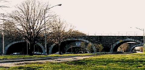
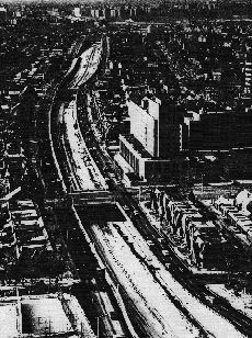
This 1998 photo shows the triple-arch overpass crossing the Grand Central Parkway at EXIT 11 (Jewel Avenue-69th Road) in Forest Hills. (Photo by Jeff Saltzman.)
|
|
|
|
|
|
|
|
|
 |
|
|
|
|
 |
|
|
|
|
|
|
|
|
Length:
Constructed:
NYSDOT Reference Route:
|
|
|
|
|
|
|
|
|
14.6 miles (23.5 kilometers)
1931-1936
NY 907M
|
|
|
|
|
|
|
|
|
 |
|
 |
|
|
|
|
|
Passenger cars only. Height restrictions apply.
Small trucks are permitted west of EXIT 4 (I-278 / Brooklyn-Queens Expressway).
|
|
|
|
|
|
|
|
|
|
|
|
|
|
|
 |
|
|
|
|
 |
|
|
|
|
|
PLANNING A LINK BETWEEN THE CITY AND THE ISLAND: The Grand Central Parkway had been planned as early as 1922, when engineers for the Queens Topographical Society proposed a limited-access parkway that would connect Queens Boulevard in Kew Gardens with Nassau County. Following the topography of Long Island's glacial moraine, the parkway was to provide views of Long Island Sound to the north, and Jamaica Bay to the south.
|
|
|
|
|
|
|
|
|
|
|
|
|
|
In 1924, Governor Al Smith appointed Robert Moses to head the Long Island State Parks Commission (LISPC). Moses turned this position into an opportunity to provide access for New York City residents to the parks and beaches of Long Island. When Jones Beach was dedicated in 1929, then-Governor Franklin D. Roosevelt supported the parkway in the following statement:
I want to see the Northern State Parkway connected with the Triborough Bridge through the Grand Central Parkway so that we who live up on the Hudson will be able to get more easily to Long Island and for us to have more visitors from Long Island.
The following year, Moses unveiled a large map of New York City before a crowd of five hundred civic leaders gathered at the Waldorf-Astoria Hotel. One of the heavy red lines - representing proposed highways - drawn across the map was the route of the Grand Central Parkway.
The route of the parkway was to extend west from the western terminus of the Northern State Parkway (then in its planning stages) to Queens Boulevard, then northern to Flushing Bay, and turning left toward the then-proposed Triborough Bridge. Along the route of the Grand Central Parkway in central and eastern Queens, Moses proposed a series of corridor parks that would preserve the last of the undeveloped portions of the heavily forested hills of the glacial moraine.
The Grand Central Parkway, originally designed as a tree-lined roadway providing "an easy way to reach Jones Beach," marked "the end of isolation for Long Island," as proclaimed by Governor Herbert H. Lehman. Ultimately, it also would provide access to the 1939-1940 World's Fair at the new Flushing Meadows-Corona Park.
|
|
|
|
|
|
|
|
|
|
|
|
|
|
|
|
|
|
|
|
 |
|
|
|
|
|
|
|
|
|
|
|
|
|
|
|
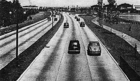
This 1944 photo shows the westbound Grand Central Parkway near LaGuardia Airport. The pedestrian and cycling trail was removed during the early 1960s widening project. (Photo by Triborough Bridge and Tunnel Authority.)
|
|
|
|
|
|
|
|
|
|
|
|
|
|
|
|
|
|
|
|
DESIGN AND CONSTRUCTION: Design specifications reflected state-of-the-art thinking in parkway design. The parkway's design took advantage of the rolling hills that marked the southern end of the glacial moraine. Landscaped areas ("ribbon parks") along the parkway not only shielded the parkway from surrounding neighborhoods, but also provided a scenic ride for motorists. In some areas, a pedestrian path was added through the "ribbon parks."
|
|
|
|
|
|
|
|
|
|
|
|
|
|
The original Grand Central Parkway section between Kew Gardens and Glen Oaks was built without dividers between eastbound and westbound traffic. Later sections were built with a grassed center median to separate opposing traffic. Throughout the length of the parkway, Moses designed bridges so that buses and trucks could not travel under them. Although the parkway allowed for a design speed of 40 MPH, the speed limit was set at 35 MPH.
The city of New York covered the costs of acquiring the right-of-way, while the state agreed to pay for the actual construction. Nearly 500 parcels of land, ranging from one square foot to roughly one million square feet, were acquired by the city for the parkway. When the parkway was finally completed, its cost had doubled from $6 million to $12 million.
|
|
|
|
|
|
|
|
|
|
|
|
Construction of the Grand Central Parkway began in July 1931 at a ceremony held at the Queens-Nassau border, jointly attended by Moses and Governor Franklin D. Roosevelt. The initial section of the parkway, a nine-mile-long, four-lane section between Kew Gardens and Glen Oaks, opened in July 1933. Its opening coincided with that of the initial section of the Northern State Parkway, which extended east to Willis Avenue in Roslyn Heights. When the new parkway opened, Queensborough Magazine described it as follows:
|
|
|
|
|
|
|
|
|
|
|
|
|
|
|
|
|
|
|
|
|
The Grand Central Parkway follows the high ground forming the longitudinal backbone of Long Island. At its eastern end it includes the highest point in Queens Borough, and from some locations along its route, both Long Island Sound to the north and Jamaica Bay to the south may be seen. It extends from Queens Boulevard at Kew Gardens, in the heart of Queens, to the Nassau County line, a distance of over seven miles. It has been paved with reinforced concrete 44 feet wide, to accommodate four lanes of traffic.
Thirteen bridges separate the grades at as many intersecting highways. The four westernmost bridges carry the cross roads over the parkway; eight of the nine in the easterly portion carry the parkway over the intersecting highways. The most interesting crossing is the most complicated. Popularly known as the "Pretzel," this series of crossings involving the Grand Central Parkway, the Interborough Parkway, Union Turnpike and Queens Boulevard is located at the eastern side of Kew Gardens. Complete separation of all express traffic crossings has been accomplished here with the use of only four bridges - three in the "Pretzel" proper and the fourth where Queens Boulevard is carried above the three express highways.
By the mid-1930's, money was running out for the Grand Central Parkway. However, Moses was able to convince Interior Secretary Harold Ickes to use part of the $44 million in Public Works Administration (PWA) funds allocated for the Triborough Bridge and its "approaches" for the parkway extension. Once he secured these funds, he ran into another problem: condemning homes along the northern shoreline of Flushing Bay for the parkway right-of-way was prohibitively expensively. Moses found another solution: he brought in enough sand from Rockaway Beach to support a six-lane parkway and a pedestrian esplanade.
This "missing link," a 7.5-mile-long, six-lane section connecting the new Triborough Bridge with Kew Gardens, opened in July 1936. One year later, a cloverleaf interchange with Horace Harding Boulevard (later Long Island Expressway) designed to serve the 1939 World's Fair opened to traffic.
|
|
|
|
|
|
|
|
|
|
|
|
|
|
|
 |
|
|
|
|
|
|
|
|
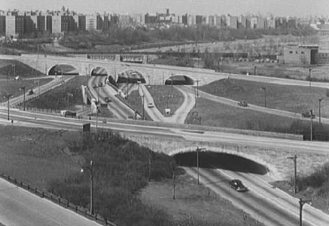
The Kew Gardens interchange in 1955. Three limited-access highways -- the Grand Central Parkway, the Jackie Robinson Parkway and the Van Wyck Expressway -- meet at this interchange. (Photo by Library of Congress, Prints and Photographs Division, Gottscho-Schleisner Collection, LC-G613-66852.)
|
|
|
|
|
|
|
|
|
|
|
|
|
|
 |
|
|
|
|
|
IF YOU BUILD IT, THEY WILL COME: The Grand Central Parkway created a faster, safer route from the New York City and beyond to Long Island. Not only did the parkway lead to the parks of Long Island, but the parkway also served as an extension of the parks. For these reasons, it did not take long for the Grand Central Parkway to garner popularity. Just after its completion in 1936, the parkway experienced the "cross-country traffic jam." From Robert A. Caro's The Power Broker:
|
|
|
|
|
|
|
|
|
|
|
|
|
|
On August 17, 1936, a little more than a month after the Triborough Bridge opened, Long Island's parkways were the scene of what some observers called the greatest traffic tie-up in the history of the metropolitan area.
Referring to it as a "cross-country traffic jam," the New York Herald Tribune was forced to conclude that the bridge had, at least directly, caused it. Apparently, a Monday-morning editorial quarterbacked, the "motoring residents of the Bronx" had all discovered at the same moment that the Triborough "brought them within easy time of Jones Beach and other cool and pleasant resorts on the south shore of Long Island" and had decided "at the same moment to head for the ocean by way of the new bridge and the Grand Central Parkway. And nearly all of them got stuck - as did countless other motorists going to and from Long Island." Public officials responded with alarm. "The Interborough Parkway, barely opened, was already impossible," Brooklyn Borough President Ingersoll noted.
Moses said he knew what to do: build more parkways in the Bronx and Westchester ("It's time we gave Westchester a break"), including the Hutchinson River Parkway Extension (in the Bronx), and on Long Island not only rush the construction of the parkways he had already proposed but also build new roads that would not be restricted, as parkways were, to private automobiles, but would also carry commercial traffic. In particular, he proposed a road down the center of Long Island - the road that would, when finally built, be known as the "Long Island Expressway."
|
|
|
|
|
|
|
|
|
|
|
|
|
|
 |
|
 |
|
|
|
|
|
|
|
|
|
LEFT: This late 1963 photo shows the completed widening project at EXIT 10 (I-495 / Long Island Expressway), near the rising New York World's Fair. RIGHT: Widening of the main roadway and cantilevering of the service roads nearing completion in this late 1963 photo taken at EXIT 16 (Parsons Boulevard-164th Street) in Briarwood. (Photos by Triborough Bridge and Tunnel Authority.)
|
|
|
|
|
|
|
|
|
|
|
|
|
|
|
|
|
|
|
|
|
|
|
|
|
|
|
 |
|
|
|
|
|
THE NEED FOR EXPANSION: In the postwar era, the rapid suburban development of Long Island and the announcement of a second World's Fair at Flushing Meadows forced officials to address chronic congested conditions on area roadways. Even with the completion of the Long Island Expressway (I-495) through Queens in the late 1950s, this congestion continued. In 1959, Moses announced a series of arterial improvements.
|
|
|
|
|
|
|
|
|
|
|
|
|
|
One of the projects, the $40 million reconstruction of the Grand Central Parkway, was to expand the Astoria-to-Kew Gardens section from six to eight lanes, and the Kew Gardens-to-Glen Oaks section from four to six lanes.
The first stage of the expansion project, between the Brooklyn-Queens Expressway (I-278) and the Clearview Expressway (I-295), was completed in 1963. In Briarwood, there was little additional right-of-way, so the Grand Central Parkway service roads were cantilevered over the main parkway. In Jamaica Estates, care was taken to minimize the number of trees that were to be uprooted in this area. The second stage of the project, between the Clearview Expressway and the Queens-Nassau border, was completed in 1971.
When the parkway was reconstructed, design specifications were updated to reflect more stringent safety standards. Median separation and shoulders were improved, while acceleration and deceleration lanes were introduced for the first time. The old wooden lightposts were replaced with metal "crookarm" and "bigloop" lightposts. Many of the bridges between Kew Gardens and Glen Oaks were rebuilt to allow buses to travel on the parkway. However, trucks remain prohibited from using the parkway.
Ralph Herman, frequent contributor to to nycroads.com and misc.transport.road, recalls the reconstruction of the Grand Central Parkway as follows:
When the Northern State Parkway was reconstructed in the late 1960s, a temporary third lane was built westbound from the city line to the Cross Island Parkway. I was away at school in the early 1970s, and remember returning during breaks as the GCP was reconstructed.
During the reconstruction of the Grand Central Parkway, a new viaduct was constructed for mainline traffic at Cross Island Parkway (EXIT 23). The original Grand Central Parkway alignments were used for collector/distributor roadways. Reconstruction of many of the ramps to and from the Cross Island Parkway increased capacity and removed the design deficiencies of the original parkway. Nevertheless, the Grand Central Parkway-Cross Island Parkway interchange, which is located entirely within Alley Pond Park, reused many of the original 1930 CGP structures, and remained within the original right of way.
More from nycroads.com and nyc.transit contributor Thomas Scannello:
What I think is very interesting was that the Grand Central Parkway once had the pedestrian walkways that were subsequently eliminated for the parkway expansion project. Many of the "greenway" advocates today say that it is not right that our parkways and expressways do not have pedestrian and bike paths for non-auto use. What is interesting was that Moses incorporated the pedestrian paths long before the "greenway" movement started, but these paths gradually were removed or fell in to disrepair long after he was gone. I think this is just another example of what a visionary Moses was.
When the Grand Central Parkway was widened in the early 1960s, non-standard exit and gore signs that utilized a black lettering-on-white background scheme (not the MUTCD standard of white-on-green) appeared. The last of these vestigial signs disappeared in the early 2000s.
EXPRESSWAY CONVERSION? After the Astoria Expressway (unbuilt I-678) was canceled in March 1971 along the Astoria Boulevard-Northern Boulevard corridor, Governor Nelson Rockefeller recommended reconstructing the Grand Central Parkway from EXIT 4 (I-278 / Brooklyn-Queens Expressway) east to EXIT 9 (I-678 / Whitestone Expressway). This section was to comprise of six lanes for use by automobiles, flanked by two lanes in each direction for use by trucks and buses.
The reconstructed expressway, which was to have the I-478 (not I-678) designation, was to relieve truck congestion through northern Queens. However, the I-478 designation lasted only two months. Citing fierce opposition, Governor Rockefeller withdrew his support for the Belt "truckway" on May 20, 1971. Subsequently, the I-478 designation shifted to the proposed Westway.
Ultimately, it did not take a costly expressway conversion to permit trucks on the Grand Central Parkway. In November 2003, city and state officials opened up the parkway from the Triborough Bridge east to EXIT 4 (I-278 / Brooklyn-Queens Expressway) to trucks with three axels or less, and ten or fewer tires. These smaller trucks represent approximately 70 percent of the truck traffic that used the Astoria Boulevard truck detour. Low underpasses preclude the use of larger trucks along this westerly section of parkway. To improve safety, officials reduced the speed limit from 50 MPH to 40 MPH west of the Brooklyn-Queens Expressway.
|
|
|
|
|
|
|
|
|
|
|
|
|
|
 |
|
 |
|
|
|
|
|
|
|
|
|
|
|
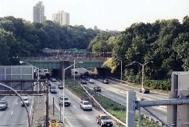
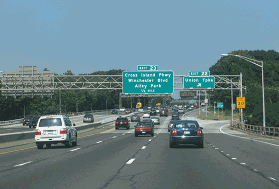
LEFT: This 1998 photo shows the Grand Central Parkway at the Kew Gardens Interchange, looking west from the Union Turnpike overpass. RIGHT: This 1998 photo shows the eastbound Grand Central Parkway at EXIT 11 (Jewel Avenue-69th Road) in Forest Hills, heading toward the Kew Gardens interchange. (Photos by Jeff Saltzman.)
|
|
|
|
|
|
|
|
|
|
|
|
|
|
|
|
|
|
|
|
CURRENT AND FUTURE IMPROVEMENTS: The New York City Department of Transportation (NYCDOT) maintains the Grand Central Parkway, and the New York City Parks Department maintains surrounding rights-of-way. Major reconstruction work is undertaken by the New York State Department of Transportation (NYSDOT), which also installs signs and reference markers.
|
|
|
|
|
|
|
|
|
|
|
|
|
|
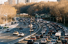
According to the NYSDOT, the Grand Central Parkway handles approximately 180,000 vehicles per day (AADT) through western Queens, and approximately 150,000 vehicles per day through eastern Queens. To handle growing traffic volumes, the NYSDOT and NYCDOT have sought ways to improve safety and efficiency on the parkway. In the mid-1990s, a rehabilitation project on the Grand Central Parkway brought new surfacing, drainage and lighting from Bell Boulevard in Hollis Hill east to the Queens-Nassau border.
The NYSDOT and the New York Metropolitan Transportation Council scheduled the following projects on the Grand Central Parkway:
Beginning in 2000, the NYSDOT performed minor rehabilitation on 59 bridges along the entire length of the parkway. In mid-2001, the agency completed a $6 million project to rehabilitate 39 bridges through central and eastern Queens. A separate $9 million project to rehabilitate 20 bridges in western Queens is scheduled was completed in late 2005.
During the summer of 2001, work at EXIT 21 (I-295 / Clearview Expressway) provided direct access from the Grand Central Parkway to both directions of Hillside Avenue (NY 25) for the first time. The NYSDOT plans to begin design studies for rebuilding the four-level "stack" interchange before the end of this decade.
The NYSDOT is installing new directional and warning signs along the length of the parkway, and new sound barriers along easterly stretches of the parkway near the Queens-Nassau border. The $11 million project was finished in late 2006.
The NYSDOT is rebuilding the Grand Central Parkway from EXIT 9 (NY 25A / Northern Boulevard) east to EXIT 10 (I-495 / Long Island Expressway), and from EXIT 13 (Jackie Robinson Parkway) east to EXIT 21 (I-295 / Clearview Expressway). The $110 million project, which includes reconstruction of the mainline pavement, rehabilitation of the cantilevered service roads, reconstruction of several bridges and erection of sound barriers, is scheduled for completion in 2008.
In Astoria, the NYSDOT is working to replace the concrete-arch Steinway Street bridge over the Grand Central Parkway. The existing span, which carried four lanes of traffic over the parkway, no longer met current weight requirements, and the state thus decided to demolish the span. The $16 million bridge replacement project, which is being carried out over six stages, originally was scheduled for completion in early 2006. However, a July 2004 accident in which a 60-foot by 4-foot concrete slab fell from the bridge onto parkway delayed the completion date to late 2007. This work is being carried out in conjunction with ongoing work to repair retaining walls from the Triborough Bridge east to the eastern leg of the Brooklyn-Queens Expressway (I-278).
The state is studying alternatives for a massive reconstruction of EXIT 10 (Long Island Expressway) at Flushing Meadows-Corona Park. Among the potential alternatives are the extension of acceleration / deceleration lanes, and improvements (such as the construction of a roundabout or jughandles) to the at-grade intersection between the LIE service roads and College Point Boulevard. The final alternative will be announced in 2008, with construction planned for sometime after 2010.
State and city transportation officials began design work on the reconstruction of the Kew Gardens interchange between the Grand Central Parkway, Van Wyck Expressway (I-678) and Jackie Robinson Parkway. The work, which will address 17 merging and weaving problem areas at the interchange, will include realigning the Grand Central Parkway mainline to provide improved visibility at highway speeds, extending acceleration-deceleration lanes (and eliminating the "stop-sign" movements), and rebuilding several bridges (including the IND subway yard overpass). The state also plans to address chronic drainage problems at the interchange, the result of a low water table and a contributing factor to periodic flooding and numerous accidents. Currently estimated at a cost of $345 million, the project is tentatively scheduled to begin in 2010 and end in 2016. In the interim, the NYSDOT reduced the speed limit through the interchange to 40 MPH (from 50 MPH) as a safety precaution.
PARKWAY GAS STATIONS: The original parkway contract included the construction of two service areas. In East Elmhurst, there is a pair of stone-faced gas stations along the eastbound and westbound lanes of the parkway just east of LaGuardia Airport. Further east, there is a median gas station (also with a stone motif) just west of EXIT 20 (Francis Lewis Boulevard). Both service areas remain in operation under contract from the New York City Parks Department.
|
|
|
|
|
|
|
|
|
|
|
|
|
|
 |
|
 |
|
|
|
|
|
|
|
|
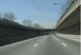
LEFT: This 2001 photo shows the westbound Grand Central Parkway through Briarwood. During the 1960-1963 reconstruction along this section, the service roads were cantilevered over the newly widened six-lane parkway. Currently, this section is undergoing rehabilitation. (Photo by Mike Tantillo.) RIGHT: This 2004 photo shows the eastbound Grand Central Parkway at EXIT 22 (Union Turnpike) in Glen Oaks. This section was rebuilt to modern standards in 1971 and rehabilitated in 1997. (Photo by Steve Anderson.)
|
|
|
|
|
|
|
|
|
|
|
|
|
|
|
|
|
|
|
 |
|
|
|
 |
|
|
|
|
|
SOURCES: "Parkway To Reach Triborough Span," The New York Times (4/01/1934); "Motorists on the Road," The New York Times (9/05/1937); New Parkways in New York City, New York City Department of Parks and Recreation (December 1937); "LI Parkway Link Will Be Widened" by Joseph C. Ingraham, The New York Times (11/29/1965); Arterial Progress 1959-1965, Triborough Bridge and Tunnel Authority (1965); "Rockefeller Agrees To Drop Plan To Construct Truck Lanes," The New York Times (5/21/1971); "Estimate of the Cost of Completing the National System of Defense Highways in New York," Federal Highway Administration and New York State Department of Transportation (1971); The Power Broker by Robert A. Caro, Vintage Books-Random House (1974); "Grand Central Parkway" by Dave Kansas and Tina Morales, Newsday (7/01/1996); "Exit Strategies" by Clara Hemphill, Newsday (10/03/1999); "Plans for New Steinway Street Bridge Over GCP Under Discussion" by John Toscano, The Queens Gazette (11/22/2000); "Problem Areas for Van Wyck-GCP Repair Noted" by Linda J. Wilson, The Queens Gazette (7/24/2003); "State Eyes Traffic Changes at LIE / GCP / Van Wyck Interchange" by Robert Brodsky, The Queens Chronicle (5/13/2004); "Overpass Collapse Closes Parkway" by Rocco Parascandola, Newsday (7/24/2004); "Probe of Fallen Concrete from GCP Overpass, New Detour Announced" by John Toscano, The Queens Gazette (7/29/2004); "End in Sight for Van Wyck Work, but More Still Ahead" by Theresa Juva, The Queens Chronicle (5/24/2007); "Tragic Toll of Queens Roadway" by Angela Montefinese, New York Post (2/24/2008); New York City Department of Transportation; New York Metropolitan Transportation Council; Office of the Queens Borough President; John Anderson; Mitch Cohen; Fred Hadley; Ralph Herman; Nathan W. Perry; Jeff Saltzman; Steve Summers; Tom Scannello.
Grand Central Parkway shields by Ralph Herman.
Lightposts by Jeff Saltzman.
|
|
|
|
|
|
|
|
|
|
|
|
|
|
|
|
 |
|
 |
|
|
|
|
|
GRAND CENTRAL PARKWAY LINKS:
|
|
|
|
|
|
|
|
|
|
|
|
|
|
|
|
|
|
|
|
|
|
GRAND CENTRAL PARKWAY PARKWAY CURRENT TRAFFIC MAPS:
New York City
|
|
|
|
|
|
|
|
|
|
|
|
 |
|
|
|
|
|
|
|
|
 |
|
|
|
|
|
THE EXITS OF METRO NEW YORK:
Grand Central Parkway exit list by Steve Anderson.
|
|
|
|
|
|
|
|
|
|
|
 |
|
|
|
|
|
|
|
|
 |
|
|
|
|
|
|
|
|
|
|
|
|
Site contents © by Eastern Roads. This is not an official site run by a government agency. Recommendations provided on this site are strictly those of the author and contributors, not of any government or corporate entity.
|
|
|
|
|
|
|
|
|
|