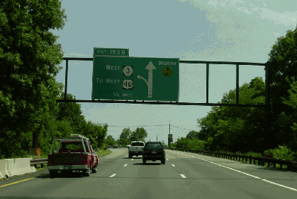
This 2002 photo shows the northbound Garden State Parkway at EXIT 153 (NJ 3) in Clifton. (Photo by Jim K. Georges.)
PLANNING THE PARKWAY: In 1945, the New Jersey State Legislature passed legislation enabling construction of the 164-mile-long NJ 4 Parkway. The parkway, which was to connect northern New Jersey with resort areas on the Atlantic coast, was proposed in response to growing congestion on major north-south routes such as US 1, US 9 and NJ 35.
Early designs for the parkway from the New Jersey State Highway Department were divided into three units: 1) the "metropolitan section," extending from existing NJ 4 in Paramus through Passaic, Essex, Union and Middlesex Counties to the Raritan River; 2) the "shore section," from the Raritan River through Middlesex, Monmouth, Ocean, Burlington, Atlantic and Cape May Counties; and 3) the unbuilt "Cross-State Parkway Extension" that would have been located in Middlesex, Somerset, and Mercer Counties. The NJ 4 Parkway was to have been financed out of annual appropriations for highway building.
With only 18 miles of parkway completed by 1950, financing the remainder of the parkway had become difficult, but officials soon came up with another plan modeled on the successful New Jersey Turnpike. On April 14, 1952, the State Legislature enacted legislation to create the New Jersey Highway Authority, which was to construct, operate and maintain a self-sufficient toll parkway from Paramus to Cape May. Orrie de Nooyer was appointed as the first executive director of the New Jersey Highway Authority. The 1952 legislation also called for the appointment of eight non-salaried commissioners to oversee the project. This legislation also gave the project a new name: the Garden State Parkway.
Following the success established by the New Jersey Turnpike Authority, the New Jersey Highway Authority adopted the power to issue bonds to finance construction of the Garden State Parkway. The payment of interest and principal on the bonds would be covered by tolls, concessions and other income. Swift construction of the parkway would enable the Highway Authority to cover interest expenses, which began accruing the moment that the $305 million in construction bonds were issued in 1952. More than $41 million was allocated for right-of-way acquisition.
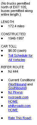
This 1955 postcard shows the Garden State Parkway near Atlantic City. (Postcard supplied by Bryan Katz.)
DESIGN CRITERIA: Gilmore Clarke, the landscape architect and engineer who worked with Robert Moses on the New York-area parkways, designed the Garden State Parkway. Clarke's design for the parkway was a hybrid of the "Pennsylvania Turnpike" model that stressed efficiency and the "Merritt Parkway" model that stressed aesthetic beauty.
Building upon the parkway guidelines outlined in the 1935 "Regulations and Procedures," the following principles governed the design of the Garden State Parkway:
Entrance to and exit from the driving lanes were to be restricted to 64 specific locations; there were to be no cross-traffic along the entire 165-mile route a total of 371 overpasses and underpasses will allow free and uninterrupted flow, eliminating all stop signs and traffic light delays. [The route was subsequently expanded to 172.4 miles.]
Roadside use for either commercial or residential purposes was to be prohibited.
A broad center island (averaging 100 feet in width) to eliminate head-on collisions was to safely separate opposing streams of traffic. The foliage of center island plantings was to form a protective screen to shield drivers from the glare of oncoming headlights.
There were to be two separate one-way roadways. Each roadway was to have two or three 12-foot-wide lanes separated by white lines.
Horizontal curves were to be super-elevated.
Steep grades and vertical curves that contribute to both uneconomical and hazardous driving were to be completely eliminated. Most grades were to be held to a maximum of three percent.
Ample stabilized shoulders were to allow the drivers of disabled vehicles to disengage them from the fast-moving traffic flow easily and safely. The areas immediately beyond the shoulders were to have shallow drainage basins, thereby eliminating dangerous, ditch-like cuts frequently found on other highways.
Interchanges and service area entrances and exits were to be designed in keeping with the high-speed, free-flow character of the driving lanes. Acceleration and deceleration areas were to be provided at these points sufficient in extent to permit vehicles to enter and leave the parkway safely and without confusion.
Elements found in existing expressways and turnpikes that are inclined to have an effect of monotony or hypnosis on a driver have been eliminated in this parkway design.
The roadway was designed for safety, comfort and speed. The surface treatment is paved and regular. Acceleration and deceleration lanes are provided for entrances, exits, and service facilities in order to smooth traffic flow. The unobstructed, sloping, stabilized shoulders allow drivers of disabled cars to pull off the roadway. "Singing" shoulders, better known as "rumble strips," alert motorists straying from the roadway. The earth moving undertaken during construction of the roadway provided an opportunity to plan for safety features.
In northern New Jersey, the "metropolitan section" of the parkway serves as a functional commuter highway and does not appear different from the expressways built in the 1950's. It follows a gradually curving route through densely populated urban and suburban areas. North of Paramus, the dual roadways follow the rolling terrain, and the parkway is separated from the communities by a wooded buffer. Wide grass and wooden medians indigenous to the Northeast separate the two roadways. From Paramus south to Cranford, the dual roadways are mostly located in a cut, with intersecting roadways and pedestrian walkways carried over the parkway cut. Earthen berms and concrete retaining walls form the walls of the cut. The narrow grass medians contain only guardrails. (Through Bloomfield and Cranford, the parkway itself is carried above the towns.) South of Cranford, the rolling terrain and wooded buffers return.
Moving south of the Raritan River, the "shore section" of the parkway takes on a more bucolic nature. Paralleling US 9, the parkway first follows the Raritan Bay shoreline, then the Atlantic Ocean shoreline, as it makes its way south toward Cape May. Along some stretches, the parkway passes through unspoiled pine barrens with forested medians as wide as 600 feet. Where the opposing lanes converge to as little as 30 feet, landscaped berms block the view of opposing traffic, eliminating the blinding effects of opposing headlights.
The curvature and grade of the roadway vary in response to local conditions. Throughout the length of the Parkway, steep grades and vertical curves have been eliminated; most grades have a maximum of three percent. The horizontal alignment consists of gentle curves and straight-aways are minimized. The right-of-way for the parkway ranged from 150 feet to 1,200 feet.
The most common bridge type over the length of the Garden State Parkway is the steel-span bridge, of which there are approximately 320. The streamlined design of these bridges is closer to the simpler, utilitarian designs that would become common in postwar expressways. Less common are the approximately 100 concrete girder-and-beam and 25 concrete elliptical arch bridges, all of which were constructed in the 1940's by the New Jersey State Highway Department for the NJ 4 Parkway.
Buildings for service areas, police barracks and toll plaza administration facilities were a one-story domestic design that was compatible with the "New Jersey Colonial" design. These buildings were of either brick or wood frame construction.
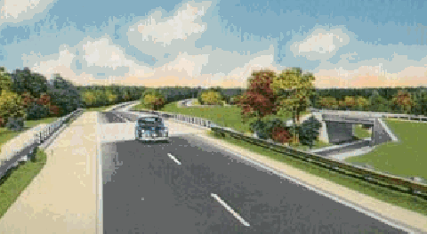
This 1960 photo shows the Garden State Parkway at EXIT 136 (Centennial Avenue) in Cranford. Note how the stone-arch overpass design borrows from the New York parkways designed by Robert Moses. (Photo by New Jersey State Highway Department.)
PARKWAY CONSTRUCTION: Under State Highway Commissioner Spencer Miller, Jr., construction of the original NJ 4 Parkway began in 1946 in Clark Township, Union County. Progress was slow: by 1950, only 18 miles of the toll-free parkway had been completed as follows:
Cape May County, milepost 8 to milepost 12 Ocean County, milepost 80 to milepost 83 Middlesex and Union counties, milepost 129 to milepost 140
With new financing backing from the New Jersey Highway Authority, ground was broken for construction of the Garden State Parkway on July 2, 1952. During 1954, one section after another was opened to traffic in time for the summer tourist season. By August of that year, some 80 miles of parkway were opened, providing uninterrupted travel between Irvington and Manahawkin, including the Raritan River Bridge. By late October, the parkway had been completed all the way south to Cape May.
On July 1, 1955, Governor Robert B. Meyner became the first person to cross the Paramus toll plaza, effectively opening the 165 miles of the parkway from Cape May to Paramus. (For the first year, motorists were detoured around Great Egg Harbor while the 1.2-mile-long parkway bridge awaited completion.) The opening of the parkway soon created demand for a new ocean-going ferry service connecting the southern terminus of the parkway in Cape May with Lewes, Delaware.
The opening of the Garden State Parkway at Paramus created bottlenecks for two years on NJ 17 between the northern terminus of the parkway and the New York State Thruway in Rockland County. On August 25, 1957, a 12-mile-long, $21.3 million extension of the parkway between these two points opened to traffic, ending the bottleneck along NJ 17.
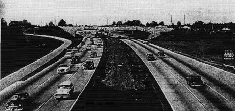
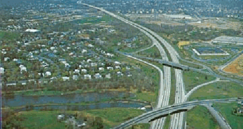
This mid-1960's aerial view shows the Garden State Parkway in northern New Jersey. (Postcard supplied by Bryan Katz.)
THE PARKWAY GROWS OVER THE YEARS: Over the 45 years, additional bonds issued by the New Jersey Highway Authority have helped finance expansion projects on the Garden State Parkway. In central New Jersey, the original four-lane parkway has been widened to as much as 14 lanes. Like the New Jersey Turnpike, the Garden State Parkway makes use of the dual-dual arrangement in the 12-lane and 14-lane sections.
In 1980, the New Jersey Highway Authority constructed the first two high-occupancy vehicle (HOV) lanes in the state along the Garden State Parkway. Two years later, after acknowledging that the lanes did not reduce congestion, but rather caused confusion that created a safety hazard, Governor Thomas Kean and transportation commissioner John Sheridan scrapped the HOV lanes. The former HOV lanes were converted to general-use lanes.
In 1987, the New Jersey Highway Authority purchased the approximately 19 miles of parkway that had been constructed by the New Jersey State Highway Department (now New Jersey Department of Transportation). These three toll-free sections are located in Cape May County (between EXIT 6 and EXIT 12), Ocean County (between EXIT 80 and EXIT 83) and Middlesex and Union counties (between EXIT 129 and EXIT 140). The NJDOT sold the sections for one dollar on the premise that tolls would never be charged on them.
In 1999, officials closed the southbound bridge over Great Egg Harbor after engineers found cracks. The cracks appeared on the original bridge dating from the mid-1950's, which originally carried one lane of traffic in each direction until it was joined by a new two-lane bridge in 1972. The older bridge had less concrete and fewer expansion joints than the new northbound bridge, and this may have contributed to fatigue on the older bridge. Officials shifted traffic onto the northbound bridge while work continued. The emergency construction work was completed within weeks.
In July 2003, the New Jersey Turnpike Authority assumed control of the Garden State Parkway from the New Jersey Highway Authority. The Turnpike Authority maintains all 172.5 miles of the parkway, including the original 32 miles of parkway constructed by the state.
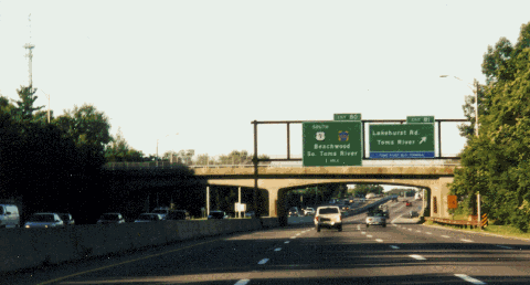
This 2001 photo shows the southbound Garden State Parkway at EXIT 81 (Lakehurst Road) in Toms River. (Photo by Steve Anderson.)
THE PARKWAY TODAY: The Turnpike Authority operates nine full service areas along the parkway at Montvale, Brookdale North, Brookdale South, Vauxhall, Cheesequake, Monmouth, Forked River, Atlantic City and Ocean View. There are also four fuel-only stations and five picnic areas. In addition, there are more than 3,600 parking spaces at 17 commuter park-and-ride locations. The Turnpike Authority also operates the PNC Bank-Garden State Arts Center, a 5,100-seat amphitheater located at EXIT 116 in Holmdel. The Holmdel-based Troop E of the New Jersey State Police patrols the parkway.
Trucks weighing more than 7,000 pounds are prohibited north of EXIT 105 (NJ 18-NJ 35-NJ 36) in Eatontown, although buses are permitted on the entire length of the parkway. Motorcycles have been permitted on the parkway only since the mid-1970's.
The speed limit on the Garden State Parkway is 65 MPH from milepost 27 north to milepost 80 and from milepost 163 north to the New Jersey-New York border. Elsewhere, the maximum posted speed limit is 55 MPH (with the exception of the Driscoll Bridge, where the posted speed limit is 45 MPH). In 2008, the state lowered the speed limit back to 55 MPH from milepost 80 north to milepost 100 following a string of fatal accidents; this section has substandard 11-foot-wide lanes.
TOLLS ON THE PARKWAY: Unlike the New Jersey Turnpike, where interchanges were kept to a minimum, the Garden State Parkway has a total of 305 entrances and exits for convenient access. Unlike the turnpike, which charges tolls only at interchanges, the parkway has eleven barrier tolls at the following locations: Cape May, Great Egg, New Gretna, Barnegat, Toms River, Asbury Park, Raritan, Union, Essex, Bergen and Hillsdale. In addition, the parkway has entrance and exit tolls at 19 locations. The first EZ-Pass tags were accepted at the Hillsdale toll plaza in December 1999, and one year later, the installation of the EZ-Pass system was completed on the parkway.
The frequency of the toll plazas, currently a source of misery for parkway motorists, was extolled in the 1950's by the designers of the parkway as follows:
Parkway engineers have proven that this wicket toll system is for the motorists own good. One criticism of today's expressways is the tedium and hypertension they create within the driver. A short "break" en route, every twenty miles or so, relieves the monotony and removes the cause of many accidents.
All of the cash toll plazas operate on an "honor system" in which motorists who do not have the 25-cent or 35-cent exact change may submit an envelope with the coins and mail it later to the New Jersey Highway Authority. Over the years, this system has proven ineffective: in any given year, only about four percent of all envelopes are returned, translating into a loss of more than $125,000 per year in 25-cent tolls.
In 1999, two separate proposals to radically change the toll structure of the Garden State Parkway were presented. State Assemblyman Alex DeCroce (R-Morris County) proposes cutting the number of mainline toll plazas from eleven to six, and charging $1.00 at each plaza. State Senator Robert Martin (R-Morris County) plans to cut the number of mainline toll plazas down to three, and charge $1.00 at each plaza and parkway entrance.
In 2001, acting Governor Donald DiFrancesco asked NJDOT chairman James Weinstein to develop a long-term plan to remove all the toll barriers on the parkway by 2012. Although it received strong support from state leaders, the plan to eliminate tolls eventually was criticized by bondholders, who considered the move as politically motivated and financially irresponsible, as well as by members of the toll collectors' union, who feared losing their jobs.
In January 2004, the New Jersey Turnpike Authority opened new high-speed EZ-Pass lanes at the Pascack Valley toll plaza as part of a $40 million project to install new EZ-Pass lanes on the parkway. During the following two and one-half years, the authority upgraded all of its toll plazas, completing the project in mid-2006. The rebuilt plazas, which formerly collected tolls in both directions, were reconfigured as follows:
Cape May (mile 19.4; northbound only) Great Egg (mile 28.8; southbound only) New Gretna (mile 53.5; northbound only) Barnegat (mile 68.9; southbound only) Toms River (mile 84.7; both directions) Asbury Park (mile 104.0; northbound only) Raritan (mile 125.8; southbound only) Union (mile 142.7; northbound only) Essex (mile 150.7; southbound only) Bergen (mile 160.4; northbound only) Pascack Valley / Hillsdale (mile 166.1; both directions)
Motorists are now are able to pass through the toll plazas at 45 MPH instead of the previous 15 MPH. The toll is 50 cents at the two remaining two-way toll plazas and $1.00 at the one-way plazas.
GOING PRIVATE? Talk of privatizing the Garden State Parkway began in 2005 when Acting Governor Richard Codey proposed either selling or leasing rights to operate the state's three toll roads to private investors in order to fill in the state's $4 billion budget deficit. In 2006, State Senator Raymond Lesniak (D-Union County) introduced legislation sell a 49 percent stake of the New Jersey Turnpike Authority to investors. Lesniak estimated the $6 billion in proceeds would be used to prop up the state's underfunded pension system. Some analysts believe a full privatization of the Turnpike Authority would raise as much as $30 billion for the state. However, Governor Jon Corzine is opposed to privatization of the parkway.
This 1999 photo shows the Garden State Parkway, looking south from the EXIT 165 (Oradell Avenue) overpass in Paramus. (Photo by Steve Anderson.)
LANE CONFIGURATIONS: Chris Blaney, New Jersey contributor to misc.transport.road, nycroads.com and phillyroads.com, provided the following lane configurations along the Garden State Parkway:
From milepost 0 north to milepost 82, there are four 12-foot-wide lanes (two in each direction), with a wide, landscaped median. Traffic volumes range from 20,000 vehicles per day (AADT) in Cape May County, to 50,000 vehicles per day through Atlantic and Ocean counties.
From milepost 82 north to milepost 94, there are six 11-foot-wide lanes (three in each direction), with a wide landscaped median and grass shoulders. This section formerly had two 12-foot-wide lanes in each direction; the shoulders were converted into additional travel lanes. Approximately 75,000 vehicles travel this section each day.
From milepost 94 north to milepost 98, there are eight 11-foot-wide lanes (four in each direction). This section formerly had three 12-foot-wide lanes in each direction; the shoulders were converted into additional travel lanes. Approximately 100,000 vehicles travel this section each day.
From milepost 98 north to milepost 105, there are ten 11-foot-wide lanes (five in each direction). This section formerly had four 12-foot-wide lanes in each direction; the shoulders were converted into additional travel lanes. Approximately 125,000 vehicles travel this section each day.
From milepost 105 north to milepost 117, there are ten lanes (five in each direction) in a 3-2-2-3 configuration. All lanes are 12 feet wide. Approximately 100,000 vehicles travel this section each day.
From milepost 117 north to milepost 126, there are twelve lanes (six in each direction) in a 3-3-3-3 configuration. The local (outer) lanes are 12 feet wide. Sometime in the mid-1990's, the express (inner) lanes were converted from two in each direction to three by eliminating the shoulders and narrowing the lanes to a width of 11 feet. Approximately 135,000 vehicles travel this section each day.
Continuing north over the Driscoll Bridge, there are eleven 11-foot-wide lanes (five northbound, six southbound). One of the southbound lanes is an acceleration lane for traffic coming from NJ 440 and I-287. (The 4,400-foot-long high fixed span, which originally opened as a four-lane span in 1954, was widened to 11 lanes in 1971.)
From milepost 127 to milepost 129, the Garden State Parkway and US 9 form a dual-dual, 12-to-14 lane configuration along with the massive interchange with the New Jersey Turnpike. The parkway has ten inner roadway lanes (five in each direction). US 9 has four outer roadway lanes (two in each direction). All lanes in this area are 12-feet wide. While the NJDOT regards these as two separate roads and not as a multiplex, this "interchange" is some two miles long and encompasses EXIT 127 and EXIT 129, providing access to the New Jersey Turnpike (I-95), I-287 and the NJ 440 Freeway. Approximately 155,000 vehicles travel this section each day.
From milepost 130 north to milepost 140, there are ten 12-foot-wide lanes (five in each direction), starting out with a landscaped median but going to a Jersey wall near milepost 132. The Jersey wall continues north to approximately milepost 150. Approximately 200,000 vehicles travel this section each day.
From milepost 140 north to milepost 145, there are eight 12-foot-wide lanes (four in each direction), in some places using the shoulders as travel lanes. Approximately 185,000 vehicles travel this section each day.
From milepost 145 north to milepost 152, there are six 11-foot-wide lanes (three in each direction). This section formerly had two 12-foot-wide lanes in each direction; the shoulders were converted into additional travel lanes. Approximately 150,000 vehicles travel this section each day.
From milepost 152 north to milepost 163, there are eight to ten 12-foot-wide lanes (four to five lanes in each direction). Approximately 115,000 vehicles travel this section each day.
From milepost 165 north to the New York State Thruway, there are four 12-foot-wide lanes (two in each direction), returning to the wide, landscaped median of the parkway's southern stretches. Traffic volumes range from 75,000 vehicles per day at milepost 165, to 40,000 vehicles per day at the New Jersey-New York border.
Sean Carolan further describes the parallel Garden State Parkway and US 9 combination between mileposts 127 and 130 in Middlesex County as follows:
US 9 SOUTHBOUND: Once you get off the parkway onto the US 9 section, there is no way to get back on the Parkway before US 9 southbound rejoins US 9 northbound (to go over the Edison Bridge). There is an exit for the parkway after the re-merge on the bridge approach, but it is marked the way all other parkway entrances are marked.
US 9 NORTHBOUND: The only access to the parkway is at the north end: a ramp that serves as much as an entrance to the Turnpike as it does the Parkway. There is also no way to get onto this road from the parkway: one can only enter the parkway from the ramp, or enter the New Jersey Turnpike, or continue on US 9, or connect to NJ 440 or Middlesex CR 501. (Middlesex CR 501, however, is virtually unmarked; it is simply signed as New Brunswick Avenue).
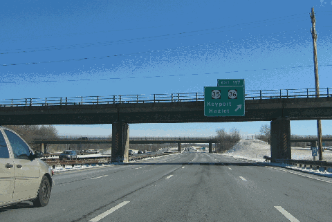
This 2006 photo shows the southbound, quad-carriageway Garden State Parkway at EXIT 117 (NJ 35-NJ 36) in Keyport. (Photo by Laura Siggia Anderson.)
IMPROVEMENTS PLANNED FOR THE PARKWAY: During the early-to-mid 2000's, the New Jersey Highway Authority (and later the New Jersey Turnpike Authority) announced more than $800 million worth of improvements to the Garden State Parkway. Some highlights of the long-term improvement plan, which is scheduled for completion in 2012, are listed as follows:
In Cape May County, new overpasses will be constructed to replace the three existing at-grade intersections. This project, which will be overseen by the NJDOT and funded by Federal legislation (ISTEA), is expected to cost $65 million. Design work began on the first new interchange at EXIT 10 (Cape May CR 657 / Stone Harbor Boulevard) in Middle Township in October 2002. Additional work is planned to create grade-separated interchanges at EXIT 8 (NJ 147 and Cape May CR 618) and EXIT 11 (Cape May CR 609).
A new interchange for EXIT 42 (Atlantic CR 561) is proposed just north of the Absecon service area. Plans have yet to be formalized for the project, which is expected to cost $25 million.
In May 2005, Acting Governor Richard Codey announced that a 17-mile stretch of the parkway - from EXIT 63 (NJ 72) in Manahwakin north to EXIT 80 (Ocean CR 530) in South Toms River - would be widened from four lanes (two in each direction) to six lanes (three in each direction). The $135 million is scheduled for completion in May 2009. Longer-range plans call for additional widening of the parkway south to EXIT 30 (NJ 52) in Somers Point. No definitive plans have been made for project, which is estimated to cost an additional $115 million.
New bridges are planned over the Bass River and Mullica River. Design work on the $50 million project began in 2005. No dates have been set for construction.
Along a 26-mile stretch of the parkway from EXIT 67 (Ocean CR 554) in Barnegat Township north to EXIT 89 (Ocean CR 528) in Lakewood, the New Jersey Turnpike Authority is adding new interchanges and upgrading existing ones. New ramps for missing movements will supplement the existing ramps at EXIT 67 (Ocean CR 554), EXIT 69 (Ocean CR 532) in Waretown-Ocean Township and EXIT 83 (US 9). New full-diamond interchanges will be constructed for EXIT 77 (Pinewald-Keswick Road) in Berkeley Township and EXIT 89 (Ocean CR 528) in Lakewood. Tollbooths will be constructed at the new ramps. The $40 million project was completed in 2006.
At EXIT 98 (NJ 138 and I-195) in Wall Township, the New Jersey Turnpike Authority is replacing the bridges carrying NJ 138 over the Garden State Parkway. The $20 million project also was completed in 2006.
At milepost 127, construction began in mid-2002 on a new parallel span for the Driscoll Bridge over the Raritan River. The new bridge, which was built just west of the existing span, carries seven southbound lanes and flanking shoulders. Construction of the new $175 million bridge was completed in April 2006, six months ahead of schedule. Work began shortly thereafter on a $75 million project to rebuild the existing Driscoll Bridge. (This part of the project took on added urgency when an eight-foot by ten-foot concrete section fell from the bridge during the summer of 2001.) The rebuilding of the bridge was completed in 2009; the rebuilt span, which accommodates eight northbound lanes and flanking shoulders, has improved sight lines. Because the new and rebuilt spans had lower clearances over the Raritan River than the existing spans, the project had to await approval from the Army Corps of Engineers.
New ramps will be built at EXIT 131A (Amtrak-NJ Transit Metropark railroad station) in Iselin at an expected cost of $4 million.
The New Jersey Turnpike Authority and the NJDOT plan to rebuild EXIT 142 (I-78) in Union Township. The $65 million project will supply the movements between the Garden State Parkway and I-78 that were left out when the westernmost section of I-278 (Union Freeway), which was to stretch from US 1-US 9 in Linden to the I-78 / NJ 24 interchange in Springfield, was canceled. At the present time, motorists leaving the northbound Garden State Parkway at EXIT 142 to go west on I-78 must first travel east on I-78 and make a U-turn at EXIT 54 (Essex CR 604 / Winans Avenue) in Hillside. Similarly, motorists leaving the southbound parkway at EXIT 142 to go east on I-78 must first travel west on I-78 and make a U-turn at EXIT 50 (Essex CR 630 / Vauxhall Road) in Vauxhall. Design work and land acquisition began in late 2000, but construction will not begin until at least 2010.
At EXIT 145 (I-280) in East Orange, the ramps between the parkway and I-280 were extended and widened from one lane to two lanes, and new EZ-Pass lanes were built at the interchange toll plaza. The $11 million project was completed in 2007, three years earlier than originally forecast.
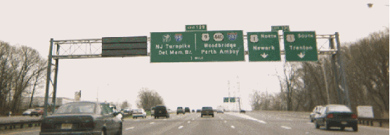
This 2001 photo shows the southbound Garden State Parkway at EXIT 130 (US 1) in Woodbridge. (Photo by Chris Mason.)
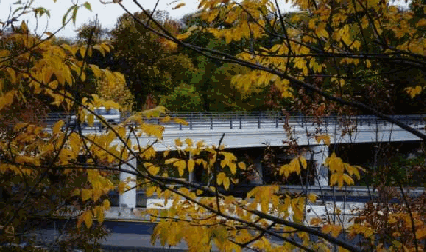
This 1998 photo shows the Scotland Hill Road overpass spanning the Garden State Parkway Extension in Spring Valley, Rockland County. (Photo by Steve Anderson.)
CONNECTING TO THE THRUWAY: The Garden State Parkway Extension extends 2.4 miles from the New Jersey-New York border north to the New York State Thruway (I-87 / I-287) in Rockland County. Operated by the New York State Thruway Authority, the "extension" has a southbound exit and a northbound entrance at Schoolhouse Road in Chestnut Ridge, and ends with a "trumpet" interchange at the Thruway in Spring Valley. The New York State section of the Garden State Parkway, which is open only to passenger cars, has no toll.
The Rockland County portion was part of a 12-mile northern extension of the Garden State Parkway through northern Bergen County. The entire length of the extension between NJ 17 in Paramus and the New York State Thruway was $21.3 million, $17.0 million of which was borne by the New Jersey Highway Authority and the remainder by the New York State Thruway Authority. After months of delay caused by labor disputes and material shortages, the 12-mile-long extension through Bergen and Rockland counties opened on August 25, 1957.
EXTENDING NORTH TO THE PALISADES: The Garden State Parkway Extension was to have been part of a "recreation corridor" stretching from the Hudson Valley south to Cape May, New Jersey. In 1946, Robert Moses pitched such a corridor by recommending that an extension of the Garden State Parkway be constructed north to the Palisades Interstate Parkway. This proposal remained on planning maps for many years.
In the late 1960's, the Tri-State Transportation Commission recommended the construction of an extension from the New York State Thruway (EXIT 14A) in Spring Valley north to the Palisades Interstate Parkway (near EXIT 11) in New Square. The extension, which was listed by the Commission as the "NY 45 Expressway," was recommended as a priority project for completion by 1975.
By 1975, the Commission recommended a shift in transportation priorities away from new limited-access highways, and toward more amenable solutions:
Although a limited-access bypass connecting the Garden State and Palisades Interstate parkways no longer seems warranted, studies of smaller-scale improvements should proceed.
Chris Blaney, contributor to nycroads.com and phillyroads.com, provided the following comments on the Garden State Parkway:
My view is the New Jersey Turnpike Authority should be disbanded and the road run by the NJDOT, but the tolls should remain so that the road is self-sustaining, not supported by tax money. Any surpluses that the road generates (especially all the shore traffic that out-of-state motorists, who would normally not contribute to the state's road-building) should go into the NJDOT budget for other needed roadwork in the state. A toll increase can eliminate the need for a gas tax hike, or vice versa.
I would eliminate tolls south of EXIT 38 (Atlantic City Expressway) and north of EXIT 163 (NJ 17), meaning that I would get rid of three out of the 11 mainline toll plazas. In addition, I would eliminate all the ramp tolls that are in place on those areas. Making the eight remaining plazas one-way (either north or south) is a good idea. I would alternate the eight plazas so they'd be south-north-south-north-south-north-south-north. To pay for the cost of eliminating of the three barrier toll plazas, I would make the cash toll $1.00 at each of the remaining plazas, the EZ-Pass peak toll 75 cents and the off-peak EZ-Pass toll 65 cents.
The GSP should be widened to an eight-lane, dual-dual (2-2-2-2) configuration from EXIT 38 (Atlantic City Expressway) north to EXIT 80 (US 9); a ten-lane, dual-dual (3-2-2-3) configuration from EXIT 80 north to EXIT 98 (I-195 / NJ 138); a 12-lane, dual-dual (3-3-3-3) configuration from EXIT 98 north to EXIT 105 (NJ 18 / NJ 35 / NJ 36); and a 14-lane, dual-dual (4-3-3-4) configuration from EXIT 105 to the Driscoll Bridge. The reconstructed Driscoll Bridge should have 16 lanes in a 2-3-3-3-2 configuration, where the outermost lanes would serve EXIT 127 (NJ 440 / I-287) and EXIT 129 (I-95 / New Jersey Turnpike). From EXIT 38 to EXIT 129, the express roadways would have interchanges only at the major locations, with crossovers every 10 to 20 miles.
SOURCES: "New Jersey's First Parkway: Route 4," New Jersey State Highway Department (1947); "Jersey Is Building $300,000,000 Road" by Joseph D. Haff, The New York Times (2/26/1953); "Final 4-Mile Link of Jersey Parkway Is Opened" by George Cable Wright, The New York Times (7/02/1955); "Manhattan Bypass Opening" by Joseph C. Ingraham, The New York Times (8/25/1957); "Autobiography of a Parkway," The New York Times (8/02/1964); Transportation 1985: A Regional Plan, Tri-State Transportation Commission (1966); Maintaining Mobility, Tri-State Regional Planning Commission (1975); "HOV Lanes Reach the End of the Road," The Star-Ledger (6/04/1982); The Merritt Parkway by Bruce Radde, Yale University Press (1993); "Palisades Interstate Parkway: National Register of Historic Places Continuation Sheet" by Susan E. Smith and Kathleen LaFrank, Palisades Interstate Park Commission (February 1998); "Plan for Two Increases Over Four Years Includes Big EZ-Pass Discounts" by P.L. Wyckoff, The Star-Ledger (11/19/1999); "Bridge To Reopen Shortly" by Donald Wittkowski, The Atlantic City Press (12/08/1999); "Defeating the Parkway Fines" by Sandra Earley, News 12-New Jersey (1/07/2000); "Authority OK's Fix for Route 78, GSP Interchange" by Doug Most, The Bergen Record (1/21/2000); "Traffic Buildup Slows EZ-Pass Progress at Shore Tolls" by Dore Carroll, The Asbury Park Press (4/07/2000); "The Garden State Parkway: A Case Study in Evaluating the Significance and Integrity of Mid-Twentieth Century Parkways" by Stacy E. Spies, National Trust for Historic Preservation (4/08/2000); "Some SUV's Are Illegal on the GSP" by Paul Mulshine, The Star-Ledger (6/18/2000); "Mixed Review of Parkway Work" by Nick Clunn, The Asbury Park Press (6/21/2000); "Toll-Free Day on Parkway?" by David M. Halbfinger, The New York Times (6/01/2001); "Plan May End Parkway Tolls" by Deborah Yaffe, The Asbury Park Press (8/10/2001); "DiFrancesco Backs Plan To Expand 65 MPH Speed Limit," The Associated Press (8/15/2001); "Driscoll Bridge To Get Second Span" by Lilo H. Stainton, The Courier News (4/09/2002); "Much Faster EZ-Pass Lanes Are Planned at Seven Toll Plazas" by Ronald Smothers, The New York Times (10/31/2002); "Big Changes Down the Road on the Garden State Parkway" by Kemberly Richardson, WABC-TV (5/06/2004); "Parkway Upgrades Traveling in Fast Lane" by Daniel Sforza, The Bergen Record (12/19/2004); "N.J. Looking into Selling Toll Roads To Get Cash" by Jennifer Moroz, The Philadelphia Inquirer (1/25/2005); "One-Way Tolls To Be Added to Parkway" by Jennifer Moroz, The Philadelphia Inquirer (3/30/2005); "Widening of Parkway Is Planned on Jersey Shore" by Iver Peterson, The New York Times (5/12/2005); "In Toll-Road Talk, Visions of Easy Cash" by Jennifer Moroz, The Philadelphia Inquirer (4/05/2006); "For Some, New Driscoll Span Opens Today," The Star-Ledger (4/10/2006); "Speeds Drop on Garden State Parkway," WABC-TV (2/29/2008); "Driscoll Bridge Work Is On Pace for 2009 Finish" by Sue Epstein, The Star-Ledger (7/26/2008); New Jersey Highway Authority; North Jersey Transportation Planning Authority; Tri-State Transportation Campaign; Chris Blaney; Anita Bonita; Sean Carolan; Phil Case; J.P. Cloninger; Rich Dean; Jay Delgado; Patrick Donnelly; David Jackino; Bryan Katz; Ayan R. Kayal; Raymond C. Martin; Christopher G. Mason; Earle Meyer; Dan Moraseski; Guy Olsen; Jim Padykula; Nathan W. Perry; Brian Polidoro; Sandy Smith; Jeff Taylor; William F. Yurasko.
Garden State Parkway shield by James Lin. Lightposts by Millerbernd Manufacturing Company. HOV lane sign by C.C. Slater.