 |
|
|
|
|
|
|
|
|
|
|
|
|
|
|
|
|
|
|
|
|
|
|
|
|
|
|
|
|
|
|
|
|
|
|
|
|
|
|
|
|
|
|
|
|
|
|
|
|
|
|
|
|
|
|
|
|
|
|
|
|
|
|
|
|
|
|
|
|
|
|
|
|
|
|
|
|
|
|
|
|
|
|
|
|
|
|
 |
|
|
|
|
 |
|
 |
|
|
|
|
|
|
|
|
|
|
|
|
|
|
|
|
 |
|
|
|
|
|
|
|
|
|
|
|
|
|
|
|
 |
|
|
|
|
|
|
|
|
|
|
|
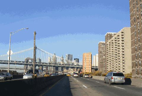
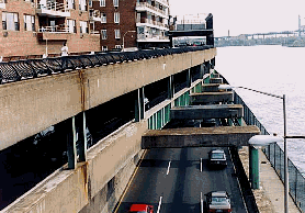
This 2004 photo shows the southbound FDR Drive approaching the Manhattan Bridge and Lower Manhattan. This elevated section of the FDR Drive was rebuilt during the 1980s. (Photo by Jason Rodriguez.)
|
|
|
|
|
|
|
|
|
 |
|
|
|
|
 |
|
|
|
|
|
|
|
|
Length:
Constructed:
NYSDOT Reference Route:
|
|
|
|
|
|
|
|
|
9.4 miles (15.2 kilometers)
1934-1955 (original construction)
1955-1966 (reconstruction of non-limited-access sections)
NY 907P
|
|
|
|
|
|
|
|
|
 |
|
 |
|
|
|
|
|
Passenger cars only. Height restrictions apply.
|
|
|
|
|
|
|
|
|
|
|
|
|
|
|
|
|
|
|
 |
|
|
|
|
|
A SCENIC HIGHWAY ALONG THE EAST RIVER: Running nine and one-half miles along the eastern edge of Manhattan from the Battery to the Triborough Bridge, the Franklin D. Roosevelt East River Drive - commonly known as the FDR Drive - forms the line of demarcation between the interior of the East Side and the East River. Like all New York City parkways, the six-lane FDR Drive is not designed to current Interstate standards and is therefore closed to commercial traffic. However, buses can use the highway in certain locations. Owing to its high traffic volumes and antiquated design, the FDR Drive has a maximum 40 MPH speed limit.
|
|
|
|
|
|
|
|
|
|
|
|
|
|
|
|
|
|
|
|
|
PLANNING AND CONSTRUCTION IN THE PRE-WAR ERA: In the 1920s, public officials and business leaders in New York City proposed waterfront highways along both the Hudson River and East River. The Regional Plan of New York and Its Environs, which was released in 1929 by the Regional Plan Association (RPA), called for a depressed express highway - called the "Chrystie-Forsyth Parkway," the precursor to the FDR Drive - along the East Side. The tenement districts along the East Side were to be replaced by high-rise buildings housing offices, stores and apartments. To maximize light and air, the widely spaced skyscrapers were to be separated by low-rise buildings and parks.
Robert Moses, arterial coordinator and parks commissioner for New York City, established his vision for the East River Drive: it was to feature six 12-foot-wide lanes, long viaducts for grade separation, and landscaping and parks between the parkway and the river. While the parkway did not have shoulders, it did have emergency pull-off ramps for disabled vehicles. Moses' riverfront parkway was to connect lower Manhattan with the proposed Triborough Bridge.
Construction of the East River Drive, which began in 1934, progressed as follows:
PARKWAY SECTION: The northernmost section, from East 92nd Street north to East 125th Street, was conceived as a controlled-access approach to the Triborough Bridge. However, the parkway faced obstacles before it could be constructed. In the end, Moses found ingenious ways to construct the highway, which opened in time of the opening of the Triborough Bridge in 1936. Within a right-of-way of 100 feet, Moses constructed a six-lane parkway and tree-lined waterfront park in a park-starved section of the city. Instead of condemning the Washburn Wire Works and Con Edison properties, he redesigned both existing facilities to accommodate the parkway. (This solution not only saved $1 million in construction costs, but also saved 1,200 jobs.)
|
|
|
|
|
|
|
|
|
|
|
|
BOULEVARD SECTIONS: Further south, from Battery Park north to East 42nd Street, and again from East 49th Street north to East 92nd Street, the East River Drive was constructed as a surface-arterial boulevard under the direction of Manhattan Borough President Stanley Issacs. Like Moses, Issacs come onto the New York City political scene from the "good government" philosophy of the 1910s and 1920s. (In his Moses biography The Power Broker, author Robert A. Caro said that Issacs provided an alternative to "getting things done:" he constructed this section without antagonizing East Side neighborhoods.) These boulevard sections were opened to traffic by 1942.
|
|
|
|
|
|
|
|
|
|
|
|
|
|
|
|
|
|
|
|
|
|
|
|
|
Much of the East River Drive was built on fill or on pile-supported relieving platforms. The section near Bellevue Hospital (between East 23rd Street and East 30th Street) was filled with rubble from bombed British cities carried as ballast in wartime ships, and was dubbed "Bristol Basin" at the time.
|
|
|
|
|
|
|
|
|
|
|
|
|
|
 |
|
 |
|
|
|
|
|
|
|
|
|
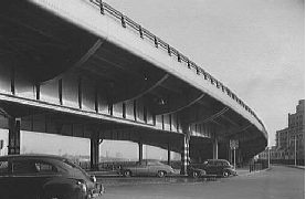
LEFT: View of the elevated FDR (East River) Drive in 1949. (Photo by Library of Congress, Prints and Photographs Division, Gottscho-Schleisner Collection, LC-G612-56274.) RIGHT: The same stretch of the elevated FDR Drive more than 50 years later. (Photo by Jim K. Georges.)
|
|
|
|
|
|
|
|
|
|
|
|
|
|
 |
|
|
|
|
|
NEW CONSTRUCTION IN THE POST-WAR ERA: In the 1940s, the New York City Planning Department recommended the completion of the East River Drive, with the proviso that the highway be open to all vehicles. It was proposed as follows:
|
|
|
|
|
|
|
|
|
|
|
|
|
|
Recently completed sections of this highway serve as a fine example of accomplishment in modern highway construction, in spite of extreme engineering difficulties and legal complications of acquiring land in diverse and confused ownership. It forms an essential link in the highway pattern connecting, at its southerly end, with the Brooklyn-Battery Tunnel and at its northerly end, with several proposed express highways: the Harlem River Drive, the Putnam Express Highway (Major Deegan Expressway), the Grand Concourse Express Highway and the Eastern Boulevard Express Highway (Bruckner Expressway).
When completed as an express highway in its entirety, it will divert large volumes of traffic from congested Manhattan streets and provide fast, convenient travel for great numbers of motorists.
However, completion of the FDR Drive did not come until well after World War II. As part of the 1945 arterial development program, Moses called for the completion of unbuilt parkway sections, and for the conversion of the existing boulevard into a controlled-access parkway from the Battery north to the Triborough Bridge.
Construction of the FDR Drive progressed as follows:
1948: The FDR Drive from East 49th Street north to East 92nd Street was converted from a boulevard to a controlled-access parkway. Between 80th and 90th Streets, Carl Schurz Park is cantilevered over the highway in the area of Gracie Mansion, the residence of the Mayor of New York.
1950: The Battery Park Underpass connecting the FDR Drive with the Brooklyn-Battery Tunnel and the West Side Highway was completed.
1952: The FDR Drive between East 42nd Street and East 49th Street was converted into a controlled-access parkway. In this section, the FDR Drive is cantilevered over the East River on two different levels. The United Nations complex forms the top layer of the cantilever over the FDR Drive.
1954: The South Street Viaduct between the Battery Park Underpass and Jackson Street (on the Lower East Side) was completed over the existing boulevard.
1960: The FDR Drive between Jackson Street and East 14th Street was converted from a boulevard to a controlled-access parkway.
1966: The FDR Drive between East 14th Street and East 42nd Street was converted from a boulevard to a controlled-access parkway. New viaducts were constructed in the areas of East 23rd Street, East 34th Street and East 42nd Street.
Throughout the length of the parkway, existing boulevard intersections with dangerous left-turn lanes were replaced with exit ramps, overpasses and viaducts.
BURYING THE SOUTH STREET VIADUCT? In 1971, shortly after the Lower Manhattan Expressway (I-78) was canceled, the New York City Department of Highways proposed an eight-lane tunnel to replace the existing South Street Viaduct section of the FDR Drive. The tunnel, which was first planned in the 1966 study by the New York City Planning Commission, "The Lower Manhattan Plan," was to run from the Battery Park Underpass north to the Brooklyn Bridge. It may have been proposed in conjunction with the "Wateredge" replacement for the West Side Highway.
The tunnel was to feature eight 12-foot-wide lanes (with no shoulders), a 14½-foot-high clearance, and a 50 MPH design speed. In addition, there was to be a diamond interchange at Wall Street, with ramps emerging from the tunnel at the service roads.
Once the tunnel opened, the elevated structure would have been torn down, and subsequently, the South Street Seaport area would have been integrated with the local street network. However, this plan never came to fruition.
|
|
|
|
|
|
|
|
|
|
|
|
|
|
 |
|
 |
|
|
|
|
|
|
|
|
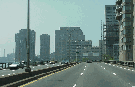
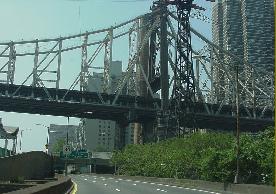
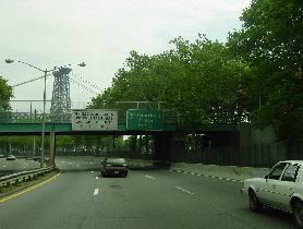
LEFT: This 2000 photo shows the southbound FDR Drive at the Queensboro (59th Street) Bridge. (Photo by Jim K. Georges.) RIGHT: This 1998 photo shows the northbound FDR Drive at East 81st Street, facing the Triborough Bridge (seen in background). This photo shows a cantilevered layout, with Carl Schurz Park on the top layer, the northbound FDR lanes on the middle layer, and the southbound FDR lanes on the bottom layer. (Photo by Jeff Saltzman.)
|
|
|
|
|
|
|
|
|
|
|
|
|
|
|
|
|
|
|
|
|
|
|
|
 |
|
|
|
|
|
A TERMITE PROBLEM: With the improvement of ecological conditions along the East River, a new menace has emerged. Millions of tiny marine borers, or "sea termites," are feeding on the wooden pilings that support parts of the FDR Drive, threatening its stability. The engineering firm Parsons Brinckeroff has been commissioned to determine the extent of the damage caused by the marine borers.
According to state and city transportation officials, most pilings will likely require installation of a plastic shrink wrap to suffocate the pests. More seriously damaged pilings will require the construction of concrete sleeves to cover them. Nevertheless, officials believe that the FDR Drive is safe and not in imminent danger of collapse.
|
|
|
|
|
|
|
|
|
|
|
|
|
|
RECENT RECONSTRUCTION EFFORTS: Reconstruction of the FDR Drive continued into the 1980s and 1990s. The New York State Department of Transportation (NYSDOT) undertook the following projects on the parkway:
During the 1980s, the NYSDOT rebuilt the viaduct from the Battery to just south of the Williamsburg Bridge. Prior to reconstruction, the "South Street Viaduct" section of the FDR Drive had been in danger of repeating the fate of the old West Side Highway.
During the mid-to-late 1990s, crews from the NYSDOT reconstructed the elevated section of the FDR Drive between 14th and 34th Streets.
The NYSDOT rebuilt the ramp from East 48th Street to the northbound FDR Drive. The old ramp was closed in 1987 after officials found it to be structurally unsound. In the ensuing years, nearby York and First avenues grew more congested, prompting officials to rebuild the ramp. The new 435-foot-ramp elevated ramp, a four-span box-girder bridge, was the first composite box girder bridge to be used in the New York metropolitan area. It was built north of the existing ramp to allow space for a future pedestrian and bicycle ramp to a proposed esplanade. The ramp reopened to traffic in October 1998 after only seven months of construction.
The NYSDOT added safety improvements from East 63rd Street north to the Triborough Bridge. The project, which included the reconstruction of the FDR Drive at East 116th Street, was completed in 2002.
A $19 million project to rehabilitate the roof structure at the Gracie Mansion tunnel was completed in 2004.
Work began in December 2002 on a four-year, $139 million project to rehabilitate both directions of the FDR Drive from East 54th Street north to East 63rd Street. The three-level tiered section of the FDR Drive through this area carries northbound traffic on the lower level and southbound traffic on the middle level, and has parks and private gardens on the top deck. The project included the rehabilitation of the East 60th Street overpass, and the rehabilitation of concrete fill and drainage system in the area of East 57th Street. Other safety improvements included extending acceleration-deceleration lanes, correcting roadway geometry, and improving bulkhead, drainage, and electrical systems. The NYSDOT also built a $40 million, 25-foot-wide "outbound detour roadway" over the East River to carry two lanes of northbound FDR Drive traffic while construction closed one carriageway at a time. This temporary viaduct was secured to the bottom of the river by a system of heavy guardrails, anchors, and 150-pound chain links, and was protected from nearby vessels by a floating fender system. The project was completed in late 2006.
CURRENT AND FUTURE IMPROVEMENTS: The New York City Department of Transportation (NYCDOT) maintains the FDR Drive, and the New York City Parks Department maintains surrounding rights-of-way. Major reconstruction work is undertaken by the New York State Department of Transportation (NYSDOT), which also installs signs and reference markers.
The NYSDOT plans to rebuild the FDR Drive viaduct from East 25th Street north to East 42nd Street. In addition to replacing the viaduct and entrance-exit ramps, the project will provide new grade-separated pedestrian access to the riverfront, a riverfront esplanade and a two-way bicycle lane. Several alternatives are currently being studied, including the construction of a vehicular tunnel along the current FDR Drive right-of-way.
According to the NYSDOT, the six-lane parkway carries approximately 175,000 vehicles per day (AADT) through Lower Manhattan, and approximately 150,000 vehicles per day through Midtown Manhattan.
|
|
|
|
|
|
|
|
|
|
|
|
|
|
 |
|
 |
|
|
|
|
|
|
|
|
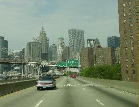
LEFT: This 2002 photo shows the southbound FDR Drive approaching the Brooklyn Bridge and the Financial District. RIGHT: This 2002 photo shows the northbound FDR Drive approaching East River Park and the Williamsburg Bridge. (Photos by Jim K. Georges.)
|
|
|
|
|
|
|
|
|
|
|
|
|
|
 |
|
|
|
|
|
THE EAST RIVER ESPLANADE: Over the years, walkways and bikeways have been constructed along the length of the FDR Drive. They were part of the original Moses design (between East 92nd Street and East 125th Street), and were extended south as Moses converted the FDR Drive into a controlled-access artery. Most of the East River Esplanade between East 63rd Street and East 125th Street was rebuilt in the 1980s; this was funded by new East Side development projects.
|
|
|
|
|
|
|
|
|
|
|
|
|
|
In 2006, Mayor Michael Bloomberg announced plans to extend the esplanade at least as far south as East 54th Street using part of the "temporary outboard viaduct" used during a recently completed construction project. The $50 million plan, which would demolish the easternmost supports jutting out over the river, would create a 20-foot-wide greenway and multi-use path. However, the Coast Guard and Army Corps of Engineers raised concerns that the esplanade - even with its reduced width - would pose a navigation hazard in the East River, while the New York State Department of Environmental Conservation (DEC) feared it would interfere with fish habitats.
According to the New York Metropolitan Transportation Council, approximately $9.5 million in additional city, state and Federal funds have been allocated for the construction of a pedestrian walkway and bike path further south to the Battery. Future plans call for the inclusion of the East River Esplanade as an eastern leg of the East Coast Greenway through Manhattan.
A NEW VISION FOR THE SOUTH STREET WATERFRONT: Some plans devised on behalf of the Downtown Alliance garnered some attention during the summer of 2002. In one plan expected to cost $35 million, designers envisioned converting the northbound lanes of the FDR Drive from the Battery Park Underpass to the Brooklyn Bridge (or the South Street Viaduct section) into a pedestrian esplanade; the southbound lanes of the highway would then be converted into two-way use (one lane in each direction). A more expensive $70 million plan calls for a 350-foot-long extension of the Battery Park Underpass beyond Broad Street (near Vietnam Veterans Plaza).
In 2005, Mayor Michael Bloomberg and the City Planning Commission announced a more aggressive $150 million plan that would rehabilitate the existing viaduct over South Street and create a two-mile-long landscaped esplanade for pedestrians and cyclists. This plan also would include a northerly extension of the Battery Park Underpass. The underside of the FDR Drive viaduct would receive new lighting and soundproofing. In addition, four piers (15, 17, 35, and 42) would be rebuilt and used as public space. The plan awaits approval from the state-run Lower Manhattan Development Corporation (LMDC).
|
|
|
|
|
|
|
|
|
|
|
|
|
|
 |
|
|
|
|
|
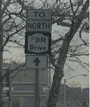
This sign just south of East 96th Street directs motorists to the northbound FDR Drive. North of New York City, state parkways have adopted the white-on-green shield, and a few parkways within the city have adopted that convention. However, this rare FDR Drive sign uses the traditional black-on-white shield used on most state highways. (Photo by Mike Tantillo.)
|
|
|
|
|
|
|
|
|
|
|
 |
|
|
|
|
|
|
|
|
|
 |
|
|
|
 |
|
|
|
|
|
SOURCES: "Master Plan: Express Highways, Parkways and Major Streets," New York City Planning Commission (1941); "Traffic Speed-Up Set for East Side" by Joseph C. Ingraham, The New York Times (3/25/1950); "South Street Viaduct Completed," The New York Times (5/29/1954); "Hour Will Be Cut for Some Trips" by Joseph C. Ingraham, The New York Times (11/21/1964); Arterial Progress 1959-1965, Triborough Bridge and Tunnel Authority (1965); The Freeway in the City, US Government Printing Office (1968); "Feasibility Study for Depressing for South Street Elevated Highway," New York City Department of Highways (1971); The Power Broker by Robert A. Caro, Vintage Books-Random House (1974); "A Guide to Civil Engineering Projects in and Around New York City," American Society of Civil Engineers (1997); "Retail Center Proposed for East Harlem" by Thomas J. Lueck, The New York Times (3/29/1998); "48th Street Ramp Reopening After 11 Years" by Carl Campanile, New York Post (10/22/1998); "Termites Gnaw FDR Drive Pilings" by James Rutenberg, New York Daily News (1/28/1999); New York: An Illustrated History by Ric Burns, James Sanders and Lisa Ades, Alfred A. Knopf Publishing-Random House (1999); "48th Street Entrance Ramp to FDR Drive," Modern Steel Construction (July 2000); "Plans for the Neglected East River Shoreline" by David W. Dunlap, The New York Times (8/01/2002); "Along the East River, Everything Old Is To Be Made New Again" by David W. Dunlap, The New York Times (3/02/2005); "Temporary Roadway for Cars May Be Transferred Into Permanent Refuge from Them" by Timothy Williams, The New York Times (12/26/2006); New York City Planning Department; New York Metropolitan Transportation Council; New York State Department of Transportation; Ralph Herman; Scott Oglesby; Nathan W. Perry; Len Pundt; Jeff Saltzman.
FDR Drive shield by Ralph Herman.
Lightposts by Jeff Saltzman.
Bike route sign by Richard C. Moeur.
|
|
|
|
|
|
|
|
|
|
|
|
|
|
|
|
 |
|
|
|
|
|
|
|
|
|
 |
|
|
|
|
|
|
|
|
 |
|
|
|
|
|
|
|
|
|
 |
|
|
|
|
|
THE EXITS OF METRO NEW YORK:
FDR Drive exit list by Steve Anderson.
|
|
|
|
|
|
|
|
|
|
|
 |
|
|
|
|
|
|
|
|
 |
|
|
|
|
|
|
|
|
|
|
|
|
Site contents © by Eastern Roads. This is not an official site run by a government agency. Recommendations provided on this site are strictly those of the author and contributors, not of any government or corporate entity.
|
|
|
|
|
|
|
|
|
|