HISTORY OF WOODHAVEN AND CROSS BAY BOULEVARDS: Woodhaven Boulevard dates back to at least the late nineteenth century, when it was called "Trotting Course Lane." The original route served the old Union Course, an important racecourse for trotting races, which was located just north of Atlantic Avenue in Woodhaven.

In the early years of the twentieth century, the city continued "Trotting Course Lane" south through Ozone Park and Howard Beach. The new "Cross Bay Boulevard" was extended south along a narrow two-lane, reinforced concrete causeway to the Rockaways.

During the 1930's, the city realigned and widened Trotting Course Lane, and renamed the route "Woodhaven Boulevard." (However, part of the original Trotting Course Lane remains in Rego Park.) The city also widened Cross Bay Boulevard leading to newly reconstructed bridges to the Rockaways.

EXPRESSWAY PLANS: In 1941, the New York City Planning Department recommended that an expressway be constructed along 11 miles of the existing Cross Bay Boulevard and Woodhaven Boulevard. The City's plan for the express highway, which was to run from the Cross Bay Veterans Memorial Bridge in the Rockaways north to Queens Boulevard (NY 25) in Elmhurst, was as follows:

This recently widened boulevard is the major artery between Queens Boulevard and the Rockaways. By its improvement as an express highway, through treatment similar to that recommended for Queens Boulevard, together with the recently improved Jamaica Bay Bridges, it would form a desirable through express route for traffic to and from the important recreation areas on the Rockaway Peninsula.

The proposed Cross Bay-Woodhaven Express Highway did not have a known numerical route designation.

Prior to the announcement of the project, some improvements had already been made to the route. Bridges were constructed to carry the boulevard over the LIRR Long Island City and Brooklyn branches, and in some locations, separated carriageways were constructed for local and express traffic.

However, the plan to upgrade Cross Bay and Woodhaven boulevards to an expressway was delayed by the onset of World War II, and ultimately, was never implemented. In the postwar era, Robert Moses, the arterial coordinator for New York City, shifted attention to creating a new north-south express route just two miles to the east of the Cross Bay-Woodhaven route. The Van Wyck Expressway (I-678) was built to connect the new Idlewild (Kennedy) International Airport to the Grand Central Parkway, and eventually, was extended north to connect with the Bronx-Whitestone Bridge.

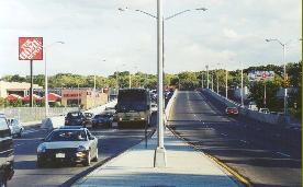
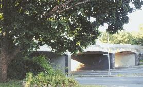
LEFT: This 2001 photo shows Woodhaven Boulevard looking south at Metropolitan Avenue on the Rego Park-Glendale border, approaching the LIRR Long Island City freight line overpass. RIGHT: This 2001 photo shows the Jackie Robinson Parkway crossing Woodhaven Boulevard on a triple-arch stone overpass. The separation of local and express roadways at select locations reveal aborted plans to upgrade the facility to the Cross Bay-Woodhaven Express Highway. (Photos by Jeff Saltzman.)

SOURCES: "Master Plan: Express Highways, Parkways and Major Streets," New York City Planning Commission (1941); Joe Brennan; Jeff Saltzman; Kevin Walsh.

  • Lightpost by Jeff Saltzman.

CROSS BAY-WOODHAVEN EXPRESS HIGHWAY LINKS:

Back to The Roads of Metro New York home page.

Site contents © by Eastern Roads. This is not an official site run by a government agency. Recommendations provided on this site are strictly those of the author and contributors, not of any government or corporate entity.

Google
 
Web nycroads.com