
|
|
||
|
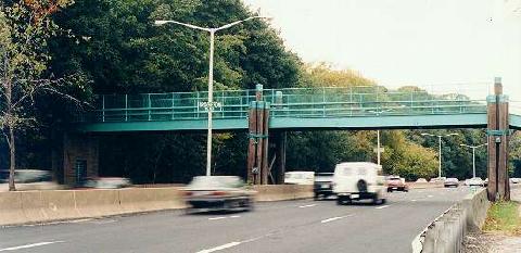
This 1997 photo shows the northbound Cross Island Parkway at the Crocheron Park pedestrian overpass in Bayside, Queens. Note the wooden-pile piers of the overpass, which was designed to blend in with the rustic setting. (Photo by Jeff Saltzman.) |
||
|
Length: |
||
|
10.6 miles (17.1 kilometers) |
||
|
Passenger cars only. Height restrictions apply. |
||

|
PLANNING THE CROSS ISLAND PARKWAY: On February 25, 1930, Robert Moses announced plans for the Cross Island Parkway before a packed audience of civic leaders at the Hotel Commodore in Manhattan. Originally planned as the "Creedmoor Parkway," the Cross Island Parkway was intended was an extension of the planned "Marginal Boulevard" (now known as the Belt Parkway) that was to run along the eastern boundary of Queens, connecting the Southern State Parkway to the Bronx-Whitestone Bridge. |
||
|
With the combined Cross Island Parkway and Belt Parkway, motorists would be able to travel from Manhattan, Brooklyn, Queens and Long Island to the eastern Bronx, Westchester and Connecticut (via the Bronx-Whitestone Bridge). Similarly, motorists from points north would be able to connect to the Northern and Southern State parkways and Long Island beaches via the Cross Island Parkway. |
||
|
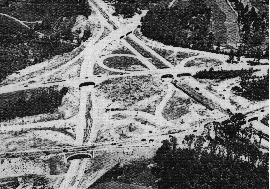
The interchange between the Cross Island Parkway and the Whitestone Parkway, as shown under construction in 1939. (Photo by Triborough Bridge and Tunnel Authority.) |
||

|
DESIGN AND CONSTRUCTION: Construction of the 36-mile-long Belt Parkway, which included the 11½-mile-long Cross Island Parkway, began in 1934. The northern end of the Cross Island Parkway was constructed on the right-of-way of the long-abandoned LIRR Whitestone branch. During construction, highway design advances that had been tested on the Long Island parkways - most notably the dark-colored main roadways and light-colored entrance and exit ramps - were applied on the Cross Island Parkway. New sodium vapor light fixtures were installed atop the traditional timber lightposts. |
||
|
On the entire Cross Island-Belt route, a total of 47 road bridges, six pedestrian overpasses, five railroad bridges and six over-water crossings were constructed. The parkway skirts 26 park areas totaling more than 3,500 acres, including Alley Pond Park, Crocheron Park, and Clearview Park and Golf Course. |
||
|
When it was dedicated on June 29, 1940, The New York Times called the $30 million Cross Island Parkway-Belt Parkway route "the greatest municipal highway venture ever attempted in an urban setting." It connected the Long Island parkways to the recently opened Bronx-Whitestone Bridge, providing easier access from upstate New York and New England to Jones Beach. A small portion of the parkway crosses into Nassau County just north of Belmont Park. |
||
|
WIDENING THE BELT PARKWAY: Initially constructed during the late 1930s with four 12-foot-wide lanes and a wide grassy median, the Cross Island Parkway allowed for later expansion to six lanes. Owing to sharp increases in postwar traffic volumes, the parkway was widened to six lanes during the late 1940s. |
||
|
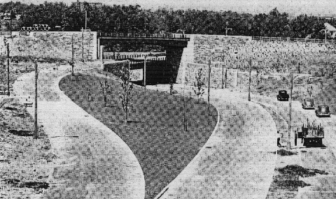
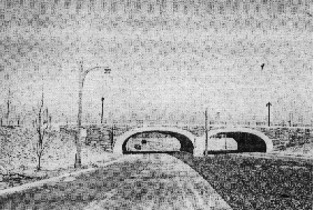
LEFT: The interchange between the Cross Island Parkway and the Grand Central Parkway, as shown under construction in the late 1930s. RIGHT: The Cross Island Parkway at the Hillside Avenue overpass, awaiting its completion in 1940. Note the four-lane design and the wide grassy median. (Photos by Triborough Bridge and Tunnel Authority.) |
||

|
DESIGN CHANGES: The New York City Department of Transportation (NYCDOT) maintains the Cross Island Parkway, and the New York City Parks Department maintains surrounding rights-of-way. Major reconstruction work is undertaken by the New York State Department of Transportation (NYSDOT), which also installs signs and reference markers. The parkway has benefited from safety improvements and renovation projects, including the reconstruction of the main roadway and ramps, and the installation of new signs and lighting, over the past 40 years. |
||
|
The NYSDOT and the New York Metropolitan Transportation Council have scheduled the following projects on the Cross Island Parkway: |
||
|
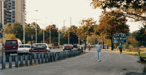
This 1997 photo shows the northbound Cross Island Parkway approaching EXIT 32 (Bell Boulevard) in Bayside, Queens. A multi-use trail for pedestrians and bicyclists was part of the original parkway design. Since this photo was taken, new decorative lighting was installed along the trail. The Throgs Neck Bridge (I-295) is in the background. (Photo by Jeff Saltzman.) |
||

|
SOURCES: "Freeways Are Now Urged," The New York Times (12/13/1936); New Parkways in New York City, New York City Department of Parks and Recreation (1937); "Belt Road To Open to Traffic Today," The New York Times (6/29/1940); "Battery Tube Loan Approved by RFC," The New York Times (6/30/1940); The Belt Parkway, New York City Department of Parks and Recreation (1940); "More Moses Loops Form," The New York Times (6/29/1941); The Power Broker by Robert A. Caro, Vintage Books-Random House (1974); "Construction Ahead: Some Good News" by Hugo Kugiya, Newsday (10/03/1999); "Governor Pataki and Mayor Giuliani Announce Long Island Expressway Plan," New York City Office of the Mayor (2/07/2000); New York City Department of Planning; New York Metropolitan Transportation Council; James J. Earl; Ralph Herman; Nathan W. Perry; Jeff Saltzman; Jim Wade. |
||

|
CROSS ISLAND PARKWAY LINKS: |
||
|
CROSS ISLAND PARKWAY CURRENT TRAFFIC MAPS: |
||
|
CROSS ISLAND PARKWAY VIDEOS: |
||

|
THE EXITS OF METRO NEW YORK: |
||
|
|
||

|
Back to The Roads of Metro New York home page. |
||
|
Site contents © by Eastern Roads. This is not an official site run by a government agency. Recommendations provided on this site are strictly those of the author and contributors, not of any government or corporate entity. |
||