
|
|
||
|
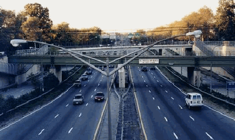
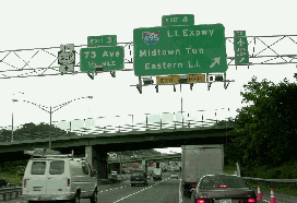
This 1998 photo shows the Clearview Expressway (I-295) facing north from EXIT 5 (NY 25A / Northern Boulevard). (Photo by Jeff Saltzman.) |
||
|
Length: |
||
|
5.3 miles (8.5 kilometers) |
||
|
FROM EFFIGY TO EXPRESSWAY: Designed to connect the Throgs Neck Bridge with the major east-west arteries of Queens and Long Island, the Clearview Expressway was one of the arterial routes recommended in the 1955 Joint Study of Arterial Facilities developed by the Triborough Bridge and Tunnel Authority (TBTA) and the Port of New York Authority. That year, the Federal Bureau of Public Roads (BPR) included the expressway as part of the preliminary Interstate highway network. |
||
|
Controversy was spurred by the planning of this north-south route through eastern Queens, as described in the following excerpt from Robert A. Caro's The Power Broker: |
||
|
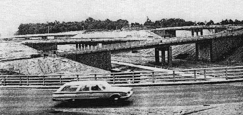
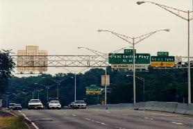
The Clearview Expressway (I-295), as shown prior to its 1960 completion, at the interchange with the Long Island Expressway (I-495) in Bayside. In the foreground is the north service road of the LIE, known locally as the Horace Harding Expressway. (Photo by Triborough Bridge and Tunnel Authority.) |
||
|
PLANNING, DESIGN AND CONSTRUCTION: As originally proposed in the Joint Study, the six-lane Clearview Expressway was to extend south from the Throgs Neck Bridge to the Long Island Expressway (I-495), utilizing the alignments of Utopia Parkway and Francis Lewis Boulevard through the communities of Auburndale and Bayside. |
||
|
According to the original design plans, the LIE-Clearview interchange allowed direct access only from the southbound Clearview to the eastbound LIE, or from the westbound LIE to the northbound Clearview. South of the LIE, the Clearview Expressway was to have become the north-south arterial Francis Lewis Boulevard. After often-rancorous community hearings, the route of the Clearview was changed to its current alignment (slightly east of the original alignment) in 1956. |
||
|
Right-of-way acquisition and construction for the Clearview Expressway began in 1957. Originally scheduled for completion in 1965, the highway was expedited as part of the 1964-1965 World's Fair arterial improvement project. The initial section of highway, from the Throgs Neck Bridge approach south to EXIT 3 (73rd Avenue) in Fresh Meadows, including the interchange with the LIE, was completed in late 1960. In the summer of 1963, the segment from 73rd Avenue to its southern terminus at Hillside Avenue (NY 25), including the "stack" interchange with the Grand Central Parkway, was opened to traffic. The 5.3-mile-long expressway was completed at a cost of $50 million. |
||
|
DIFFERENT INTERSTATE DESIGNATIONS OVER THE YEARS: In the years since it was included in the Federal-aid highway program, the Clearview Expressway had a number of different Interstate designations. These designations were as follows: |
||
|
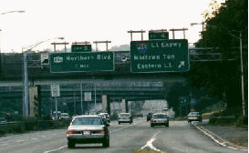
LEFT: This 1997 photo shows the northbound Clearview Expressway (I-295) at EXIT 4 (I-495 / Long Island Expressway). RIGHT: This 2000 photo shows the southbound Clearview Expressway near Clearview Golf Course, just south of the Throgs Neck Bridge. (Photo by Jim K. Georges.) |
||
|
DESIGN FLAWS AT A CRITICAL INTERCHANGE: Like other pre- and early-Interstate era expressways in New York City, the Clearview Expressway is not without its design flaws. One specific example is the interchange between the Clearview Expressway and the Long Island Expressway, which features tightly curved, single-lane ramps between the two roads. |
||
|
Ralph Herman, frequent contributor to nycroads.com, posted the following in misc.transport.road: |
||
|
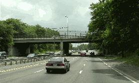
LEFT: This 2000 photo shows the southbound Clearview Expressway (I-295) at EXIT 4 (I-495 / Long Island Expressway). (Photo by Jim K. Georges.) RIGHT: This 1997 photo shows the Clearview Expressway making its way south through Cunningham Park toward the Grand Central Parkway. (Photo by Jeff Saltzman.) |
||


|
THE CLEARVIEW EXTENSION (1955-1971): Proposed as part of the original "I-78 through NYC" project, the Clearview Expressway extension was to have extended south from Hillside Avenue (NY 25). The proposed extension first appeared on a map of planned Interstate routes published by the BPR in 1955, but did not appear on TBTA and NYSDPW plans until at least 1957. |
||
|
At the southern terminus of the Clearview Expressway, I-78 was to continue west along the Nassau Expressway and Bushwick Expressway into Brooklyn. The 6.3-mile-long, $194 million Clearview Expressway extension was to have alleviated congestion on the Van Wyck Expressway (I-678) and the Belt Parkway by creating another north-south, controlled-access route to Kennedy Airport that was to be open to all traffic. However, by the late 1960's, concerns over the lack of available funds and community opposition delayed this segment. On March 24, 1971, Governor Nelson Rockefeller officially killed the southern extension of the Clearview Expressway, along with several other Interstate highway projects in New York City. SHOULD ANOTHER ROAD LINK BE PROVIDED TO JFK? Over the years, a number of different road and rail proposals have been suggested to relieve congestion on the Van Wyck Expressway and the Cross Island Parkway. In 1997, Daniel T. Dey, frequent contributor to nycroads.com, suggested reviving the Clearview Expressway Extension from Hillside Avenue south to Kennedy Airport, with connections to the Belt Parkway and the Nassau Expressway, as a viable Interstate highway project. His letter was met with the following response from Peter G. King, a planning official at the District 11 (New York City) office of the NYSDOT: The problem of congestion on arterials serving Kennedy Airport is being addressed in several ways. The New York State Department of Transportation is in the process of initiating a study to define operational problems along the Whitestone, Van Wyck and Clearview expressways, as well as on the Belt Parkway. These studies will lead to the development of a range of alternative proposals to address the movement of people and goods. Airport access will also be addressed as part of overall mobility issues. Your suggestion that the Clearview Expressway be completed to Kennedy Airport as a relief to the Van Wyck Expressway has many problems. Such a project would have devastating impacts on well-established residential Queens communities. Moreover, building the Clearview all the way to Kennedy Airport would probably result in an increase of vehicle-miles of travel. Vehicle-miles of travel are the primary means of ascertaining and measuring the contribution to air pollution made by motor vehicles. Building more high-speed highways tends to generate additional motor vehicle use. This phenomenon is well documented across the country. You are correct in noting that the Clearview Expressway is I-295. However, this designation ends at Hillside Avenue. The portion of the Clearview south of Hillside Avenue would no longer be eligible for Federal Interstate funding, since that segment was formally de-designated as an Interstate route. Re-designation would be an extremely difficult, if not impossible process and of very questionable desirability. Finally, given the problems that the New York City area has in meeting Federal clean air standards, it would not be prudent to attempt more new highway construction. Environmental considerations would probably make such a project almost impossible to move forward. Instead, the emphasis should be on making more efficient use of the existing highway system and on encouraging mass transit. In his response to the NYSDOT letter above, Dey reiterated his support for the Clearview Expressway Extension in an editorial letter appearing in Newsday: One alternative to light rail links to Kennedy Airport has been overlooked: the formerly proposed extension of the Clearview Expressway. It does not take a genius to figure out that this policy (of maximizing use of the existing highway and mass transit systems) is not working. The roads and rails are equally overcrowded, and the air quality in the New York area is almost as bad as it is in the Los Angeles basin. If Federal clean air standards discourage highway construction, then they are woefully counterproductive in the tri-state area. This does not mean that we should completely scuttle mass transit, but in regions as heavily populated and traveled as New York City and Long Island, we must not forgo roads for rails, or vice versa. We must be willing to work equally on both. AND HOW WOULD IT BE DONE? From both political and geological standpoints, any southward extension of the Clearview Expressway would be difficult to construct. To mitigate concerns that would inevitably arise from the expressway, misc.transport.road and nycroads.com contributor Douglas A. Willinger suggested the following: Has anyone taken a look at the feasibility of a southern extension of the Clearview Expressway, perhaps combining the use of Francis Lewis Boulevard cantilevered over a depressed freeway (similar to that found on a section of the Grand Central Parkway), cut-and-cover, and bored tunnel segments? In response, Yuri Dieujuste, another contributor to nycroads.com, said that the right-of-way along Francis Lewis Boulevard that would be considered is a narrow, four-lane divided street that lacks the left-turn lanes found on other area roads such as Hillside Avenue (NY 25) and Union Turnpike. According to Dieujuste, any depressed or cut-and-cover expressway proposal would still require widespread condemnation. A deep-bored tunnel would be a solution, albeit an expensive one. Finally, Ralph Herman also expressed concerns about the depressed expressway and tunnel suggestions, citing the high water table and attendant flooding problems in southeast Queens. THE JFK EXPRESSWAY: PART OF THE CLEARVIEW EXTENSION? One section of what was to have been the Clearview Expressway Extension was constructed (albeit somewhat west of the original southern terminus of Farmers Boulevard) between 1988 and 1992. The JFK Expressway, which was constructed along 150th Street in the eastern half of the airport grounds, links to the Belt Parkway, Conduit Avenue (NY 27) and the Nassau Expressway (NY 878). |
||
|
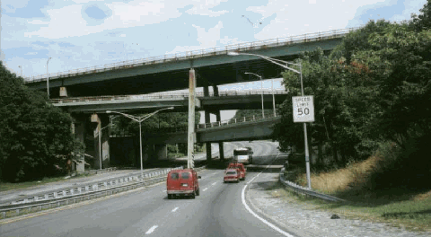
This 2000 photo shows the four-level "stack" interchange at EXIT 1 (Grand Central Parkway) in Hollis Hill, Queens. Completed in 1963, this "stack" interchange, the only interchange of its type in New York City, is slated for long-term reconstruction. The Clearview Expressway was to continue south of this point to Kennedy Airport. (Photo by Doug Kerr, www.gribblenation.com.) |
||

|
SOURCES: Joint Study of Arterial Facilities; The Port of New York Authority-Triborough Bridge and Tunnel Authority (1955); "Queens Approach Agreed On for New Throgs Neck Bridge," The New York Times (9/26/1956); "Throgs Neck Bridge Is Opening Today" by Robert Conley, The New York Times (1/11/1961); "LI Parkway Link Will Be Widened" by Joseph C. Ingraham, The New York Times (11/29/1965); Arterial Progress 1959-1965, Triborough Bridge and Tunnel Authority (1965); Transportation 1985: A Regional Plan, Tri-State Transportation Commission (1966); "Lower Manhattan Road Killed Under State Plan" by Francis X. Clines, The New York Times (3/25/1971); The Power Broker by Robert A. Caro, Vintage Books-Random House (1974); "Highway Hopes That Faded by Sidney C. Schaer, Newsday (11/05/1999); Six Bridges: The Legacy of Othmar H. Ammann by Darl Rastorfer, Yale University Press (2000); New York Metropolitan Transportation Council; New York State Department of Transportation; Daniel T. Dey; Yuri Dieujuste; Ralph Herman; Douglas Kerr; Raymond C. Martin; Scott Oglesby; Jeff Saltzman; Tom Scannello; Stephen Summers; Douglas A. Willinger. |
||

|
CLEARVIEW EXPRESSWAY LINKS: |
||
|
CLEARVIEW EXPRESSWAY CURRENT TRAFFIC MAPS: |
||
|
CLEARVIEW EXPRESSWAY VIDEOS: |
||

|
THE EXITS OF METRO NEW YORK: |
||
|
|
||

|
Back to The Roads of Metro New York home page. |
||
|
Site contents © by Eastern Roads. This is not an official site run by a government agency. Recommendations provided on this site are strictly those of the author and contributors, not of any government or corporate entity. |
||