 |
|
|
|
|
|
|
|
|
|
|
|
|
|
|
|
|
|
|
|
|
|
|
|
|
|
|
|
|
|
|
|
|
|
|
|
|
|
|
|
|
|
|
|
|
|
|
|
|
|
|
|
|
|
|
 |
|
|
|
|
 |
|
|
|
|
 |
|
|
|
|
|
|
|
|
|
|
|
|
|
|
|
|
 |
|
|
|
|
|
|
|
|
|
|
|
|
|
|
|
 |
|
|
|
|
|
|
|
|
|
|
|
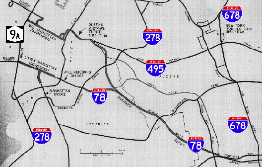
This 1963 map from Future Arterial Program for New York City shows the revised route of the unbuilt Bushwick Expressway in relation to the arterial network in northern Brooklyn, western Queens and lower Manhattan. There was to be an additional north-south connection between I-78 and the Queens-Midtown Tunnel (I-495), part of the proposed third tube project, as shown on the map. In addition, the "north route" alternative is shown, but the "south route" is not. The map also does not show the route of the Cross Brooklyn Expressway. (Map by Triborough Bridge and Tunnel Authority.)
|
|
|
|
|
|
|
|
|
 |
|
|
|
|
 |
|
|
|
|
|
AN EAST-WEST EXPRESSWAY FOR NORTHERN BROOKLYN: Planning for the Bushwick Expressway began as early as 1936, when the Regional Plan Association (RPA) recommended construction of a controlled-access expressway that would be open to all traffic.
Two years later, under a joint grade crossing elimination project with the New York State Transit Commission, the Triborough Bridge Authority made funds available for a spur of the Belt Parkway from the mainline route northwest to Atlantic Avenue. The parkway spur was to run in the median of Conduit Boulevard between Howard Beach, Queens and East New York, Brooklyn. Although the parkway spur was never built, some of the original bridges remain.
|
|
|
|
|
|
|
|
|
|
|
|
|
|
|
|
|
|
|
|
|
In 1955, the Bushwick Expressway appeared in a report drafted by Robert Moses, the Joint Study of Arterial Facilities, which would dictate expressway and bridge construction over the next decade. As outlined in the report, the Bushwick Expressway was to connect the Williamsburg Bridge and lower Manhattan with Kennedy Airport. In addition to providing an east-west express route open to all vehicles through Brooklyn, the expressway was to provide access to the south shore of Long Island.
Later that year, the Federal Bureau of Public Roads (BPR) added the Bushwick Expressway as part of the preliminary Interstate highway network. Three years later, the route was designated I-78, making it eligible for 90 percent Federal financing (The state and city governments were to pay the remaining ten percent of the construction and right-of-way costs.)
THE BUSHWICK ALIGNMENT ALTERNATIVES: In his 1963 report Future Arterial Program for New York City, Moses consulted the Blauvelt Engineering Company to develop alternative routes for the Bushwick Expressway. The three selected routes were as follows:
SOUTH ROUTE: The originally proposed route for the Bushwick Expressway, I-78 would have paralleled Bushwick Avenue and Broadway from the Williamsburg Bridge east through the Brooklyn communities of Williamsburg and Bushwick. In the vicinity of Broadway Junction, the Bushwick Expressway would have intersected with the proposed Cross Brooklyn and Queens-Interboro expressways (the early incarnation of New York's I-695), as well as with the Jackie Robinson Parkway. For approximately a 20-block distance eastward through East New York, the Bushwick Expressway would have been constructed either on top of or parallel to Atlantic Avenue. Heading southeast onto Conduit Boulevard (NY 27), the expressway lanes would have been constructed in the large grassy median between the eastbound and westbound lanes of the boulevard. The setup was to continue east to the Belt Parkway-Nassau Expressway interchange.
MIDDLE ROUTE: Beginning at the Williamsburg Bridge, I-78 would have veered from the Broadway (southern) alignment at Flushing Avenue, and continued east along Flushing Avenue. At Wyckoff Avenue, after the spur to the Queens-Midtown Tunnel (which would have been routed roughly along Newton Creek) joins the mainline expressway, the route would have veered southeast. The Bushwick Expressway would have straddled the Brooklyn-Queens border, cutting through the Cemetery of the Evergreens and Highland Park. South of Highland Park, the expressway would have gone roughly along Force Tube Avenue to the western terminus of Conduit Boulevard (at Atlantic Avenue), and continued along the wide Conduit Boulevard median to the Belt Parkway-Nassau Expressway interchange.
NORTH ROUTE: The northern alternative for the Bushwick Expressway was to begin by utilizing the middle alignment, but was to continue along Flushing Avenue into Queens. The expressway was to veer east onto the right-of-way for the LIRR Long Island City freight spur (joining the Queens-Midtown Tunnel spur at this location) to a point just east of Woodhaven Boulevard, then turn south at the (partially abandoned) LIRR Rockaway branch. It was to continue along the railroad right-of-way to the Belt Parkway-Nassau Expressway interchange.
THE ROUTE IS SELECTED: The engineers recommended construction of the middle route to not only fulfill the original objective of the Bushwick Expressway - to provide an expressway route from lower Manhattan to the south shore of Long Island - but also to provide a connection to the Queens-Midtown Tunnel. The middle alternative, which was estimated to cost $240 million, would have required the relocation of 3,850 families, 350 businesses and 14 community buildings. It was scheduled for completion by 1974.
The other alternatives were removed from consideration for the following reasons:
SOUTH ROUTE: Although this was the route originally proposed, the potential disruption to surrounding communities would have been greater. The expressway would have displaced an estimated 4,850 families and more than 400 businesses. Moreover, no connection to the Queens-Midtown Tunnel would have been provided.
NORTH ROUTE: While community opposition would have been mitigated somewhat along the railroad rights-of-way (some 3,100 families and 275 businesses would have been displaced), the rights-of-way would not have been wide enough to permit construction of the expressway, and additional land would had to have been acquired. Furthermore, with the New York City Transit Authority seeking to operate over the complete length of the former LIRR Rockaway Branch, constructing the expressway over active railroad lines would have been difficult.
|
|
|
|
|
|
|
|
|
|
|
|
|
|
|
|
|
ENMESHED IN CONTROVERSY: Like most post-war highway projects in New York City, the Bushwick Expressway was not without its controversy. In 1966, Mayor John V. Lindsay advocated the construction of the Cross Brooklyn Expressway, a more southerly route in the direction of the Verrazano Bridge, as a substitute for the Bushwick Expressway. Lindsay argued that the Bushwick would lead peak rush-hour traffic into lower Manhattan, and that the Cross Brooklyn alternative would make traffic pass Manhattan via the Verrazano Bridge. His opinion was buttressed by that of the Regional Plan Association (RPA), which that year argued against the construction of new radial expressways into Manhattan.
|
|
|
|
|
|
|
|
|
|
|
|
|
|
|
|
|
|
|
|
|
Moses, who until the late 1960s was the arterial coordinator for New York City, argued that both the Bushwick and Cross Brooklyn expressways were necessary for an integrated highway solution in the borough of Brooklyn. The Tri-State Transportation Commission sided with Moses, recommending that both expressways be completed by 1975. It stated the purpose and benefits of the Bushwick Expressway as follows:
The Bushwick Expressway, an east-west route through northern Brooklyn, will provide a relief route for the Long Island Expressway, as well as a replacement for congested arterial streets. Its construction will offer an opportunity to revitalize a declining area, and to improve mass transit.
Lindsay succeeded in removing the route from the city master plan in 1969. On March 24, 1971, Governor Nelson Rockefeller killed the Bushwick Expressway, along with the other unbuilt sections of the controversial route of I-78 through New York City.
Over the years, directional signs along the Brooklyn-Queens Expressway hinted at the arrival (and demise) of the Bushwick Expressway through Brooklyn. According to nycroads.com contributor Ralph Herman, directional signs for the Williamsburg Bridge had I-78 marker shields in the 1960s and early 1970s. When the New York State Department of Transportation (NYSDOT) replaced the directional signs along I-278 in the mid-1970s, the new signs did not have shields for I-78.
|
|
|
|
|
|
|
|
|
|
|
|
|
|
 |
|
 |
|
|
|
|
|
|
|
|
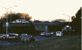
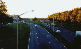
Two 1998 photos of the westbound Conduit Boulevard in Howard Beach, Queens. The overpass on the left, which carries Cross Bay Boulevard, was built in the late 1940s for a Belt Parkway spur, the precursor of the Bushwick Expressway. The overpass was rebuilt during 2003 and 2004. (Photos by Jeff Saltzman.)
|
|
|
|
|
|
|
|
|
|
|
|
|
|
|
|
|
|
|
|
SHOULD THE BUSHWICK EXPRESSWAY BE REVIVED? In 1998, there was a discussion in the misc.transport.road newsgroup on reviving plans for Interstate 78 through New York City. Douglas A. Willinger of the Takoma Park Highway Design Studio outlined his plan to resurrect the Bushwick Expressway through Brooklyn as follows:
NEW INTERSTATE 78: Bushwick route to the Williamsburg Bridge, and/or Atlantic Avenue, the former with full, deep-bore tunneling for segments to preserve existing neighborhoods as now done in Europe, the latter an innovative cut and cover rebuild of the Atlantic Avenue LIRR tunnel, consolidated with new underground expressway to the Manhattan Bridge beneath a new linear park, also encased.
|
|
|
|
|
|
|
|
|
|
|
|
|
|
Two years later, nycroads.com contributor Tom Scannello posted the following ideas on the engineering challenges that would have been faced along the Bushwick Expressway:
If the Bushwick Expressway project were ever approved, this would have been an incredibly difficult engineering undertaking:
The Long Island Rail Road (LIRR) tracks from Jamaica station to Flatbush Avenue tunnel under Atlantic Avenue at some locations. The LIRR right-of-way is also elevated along a portion of the route. The engineers would probably have had to tunnel the currently elevated portion of the LIRR (at the Nostrand Avenue station) in order to make room for the expressway.
The Bushwick Expressway would probably have been constructed as an elevated expressway along Atlantic Avenue, since there is not much right-of-way next to the present Atlantic Avenue roadway for a surface expressway. The highway engineers may have had some luck in developing this route: the present surface arterial has (for the most part) three lanes in each direction.
Because the LIRR tunnels are beneath Atlantic Avenue, engineers would not have been able to design the highway like other elevated highway designs in the New York metropolitan area. For example, there is the elevated highway design of the Gowanus Expressway, which is comprised of large supports that line the median of Third Avenue through Sunset Park, Brooklyn. If the Bushwick Expressway had utilized this design, it is possible that the supports may have collapsed into the LIRR tunnel.
My guess is that the engineers would have elevated the Bushwick Expressway in a similar fashion to that of the elevated Long Island Expressway just east of the Brooklyn-Queens Expressway. Along this section of the LIE, the supports are located on either side of the expressway. The engineers would have had to make sure that the stanchions did not interfere with the LIRR tunnel. Depending on the width of the LIRR tunnel, additional land acquisition along the affected section of Atlantic Avenue in East New York may have had to occur. The elevated Bushwick may have been able to "squeeze" above the existing road right of-way with few eminent domain issues (only if the LIRR tunnel did not pose problems).
Would the elevated Bushwick Expressway have suffered the same critical fate as the Gowanus Expressway, to such extent as it was an eyesore that destroyed neighborhoods? Probably. Would it have been a critical link in the expressway infrastructure and transportation network of the New York metropolitan area? Most definitely. The Bushwick Expressway would have provided traffic relief for the Long Island and the Van Wyck Expressways.
The Bushwick Expressway may not have been the great engineering challenge that the Cross Bronx Expressway was, but it would have ranked very high on the list. Since we will probably never see the Bushwick Expressway in our lifetimes, it is interesting to think about "what could have been" when traveling along its proposed route today.
REBUILDING PART OF AN "UNBUILT" EXPRESSWAY: The NYSDOT recently rebuilt the overpass that carries Cross Bay Boulevard over Conduit Boulevard. Built in 1949, the overpass was intended to cross the Bushwick Expressway. During reconstruction, two of the eight lanes on the overpass were closed at a time. The two-year-long, $9.7 million reconstruction project was finished in late 2004.
|
|
|
|
|
|
|
|
|
|
|
|
|
|
 |
|
|
|
|
|
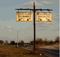
ROAD TO NOWHERE: One of the old directional signs (pre-MUTCD, 1950s-era) along Conduit Boulevard near the Brooklyn-Queens border. The barren space in the median of Conduit Boulevard was reserved for the Bushwick Expressway, just before I-78 was to become the Nassau Expressway. Traffic for "Long Island-Rockaways" was to go on a entrance ramp leading to the unbuilt expressway. It appears that sign crews jumped the gun on this one. (Photo by Jeff Saltzman.)
|
|
|
|
|
|
|
|
|
|
|
 |
|
|
|
|
|
|
|
|
|
 |
|
|
|
 |
|
|
|
|
|
SOURCES: "Freeways Are Now Urged," The New York Times (12/13/1936); The Belt Parkway, New York City Department of Parks and Recreation (1940); Joint Study of Arterial Facilities, The Port of New York Authority and the Triborough Bridge and Tunnel Authority (1955); "Future Arterial Program for New York City," Triborough Bridge and Tunnel Authority (1963); Arterial Progress 1959-1965, Triborough Bridge and Tunnel Authority (1965); "Lindsay Asks State To Accept a Cross-Brooklyn Expressway" by Charles G. Bennett, The New York Times (9/14/1966); "Cross Brooklyn Expressway Route Selection Study," Triborough Bridge and Tunnel Authority (1966); Transportation 1985: A Regional Plan, Tri-State Transportation Commission (1966); "Lower Manhattan Road Killed Under State Plan" by Francis X. Clines, The New York Times (3/25/1971); How To Save Urban America by William A. Caldwell, Regional Plan Association-Signet Books (1973); "Queens Interborough Expressway: Planning Report," Vollmer Associates (1973); "Highway Hopes That Faded by Sidney C. Schaer, Newsday (11/05/1999); "The Expressway That Couldn't," The Ridgewood Times (6/22/2000); "Cross Bay Boulevard Bridge To Get $9.7 Million Rebuild" by Alex Harrison, The Times-Ledger (4/10/2003); Ralph Herman; Jeff Saltzman; Tom Scannello; Douglas A. Willinger.
I-78 shield by Ralph Herman.
Lightposts by Jeff Saltzman.
|
|
|
|
|
|
|
|
|
|
|
|
|
|
|
|
|
|
|
 |
|
|
|
|
|
|
|
|
|
 |
|
|
|
|
|
|
|
|
 |
|
|
|
|
|
|
|
|
|
|
|
|
Site contents © by Eastern Roads. This is not an official site run by a government agency. Recommendations provided on this site are strictly those of the author and contributors, not of any government or corporate entity.
|
|
|
|
|
|
|
|
|
|